Headlines
- A tropical wave is moving near Hispaniola, and likely to cross Cuba over the next couple of days
- We have a lot more questions than answers about the strength and intensity of the tropical system after this
- However, it poses a distinct threat to Florida and the northern Gulf of Mexico coast
- Rainfall is a particular concern due to a lack of steering currents next week
Tropical wave getting better organized
The tropical wave we’ve been discussing for much of this week has a better satellite appearance today as it is bringing a large area of showers and thunderstorms to the Caribbean. As of Thursday morning, the center of this activity appears to be situated near Hispaniola, and the system should continue to move steadily to the west-northwest.
Our forecast models have really struggled to get a handle on the evolution and track of this tropical system over the last couple of days, and there has been a decided westward shift in the guidance. Whereas it once appeared that the tropical system—which if it were to develop would be named Debby—would travel to the east of Florida, it now appears as though it will remain south of Florida and move into the eastern Gulf of Mexico.
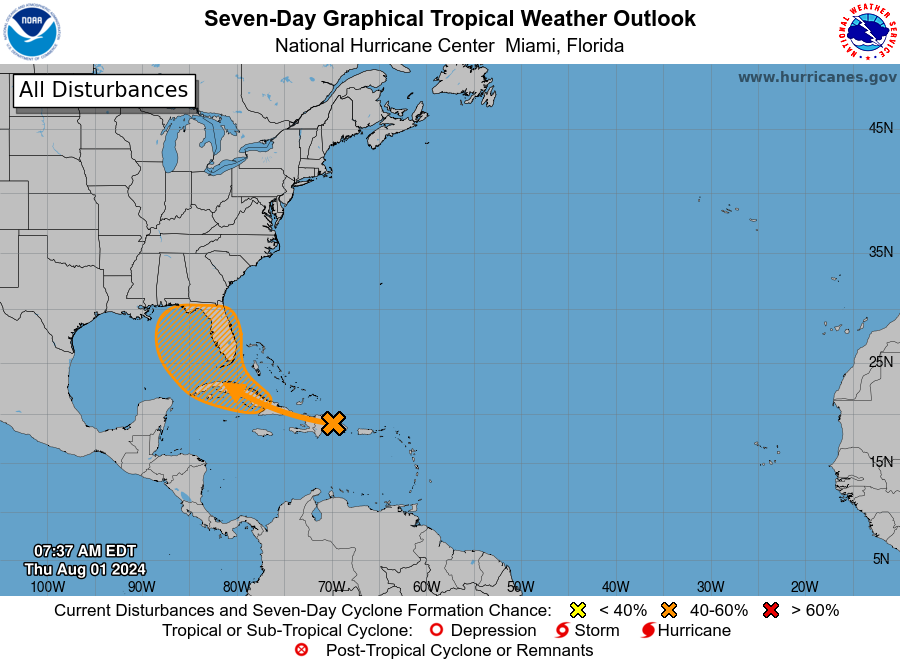
One reason for this is that it no longer appears as though the tropical wave will become Debby any time soon. A more rapidly strengthening system favored a poleward turn more quickly into the Atlantic. However, most of the model guidance now keeps the system below tropical depression strength for the next several days as it moves over Cuba and into the southeastern Gulf of Mexico this weekend.
What happens in the Gulf of Mexico?
If only what happened in the Gulf stayed in the Gulf. As the outlook from the National Hurricane Center outlook above makes clear, there is broad uncertainty about what happens to the system as it moves off of Cuba. It could conceivably move into Florida, or over any part of the eastern Gulf of Mexico. As of this morning most of the guidance favors a blob moving into the Eastern Gulf.
If the storm remains offshore, it would find more favorable conditions for development this weekend, or early next week. So it’s possible, and perhaps even likely, that we’ll see a tropical storm off the west coast of Florida in three to five days time. At a minimum, this will be a rainmaker. And depending on how strong it gets, there could be wind and storm surge threats as well. However, it is a fool’s errand to try and make such predictions now as there is a ton of uncertainty about a storm that a) has not yet formed, b) must still traverse the spine of Cuba, and c) may then interact with parts of Florida’s landmass. The bottom line is that residents of Cuba, Florida, and southern Mississippi and Alabama (and maybe even Louisiana) should be tracking the storm’s progress over the coming days.
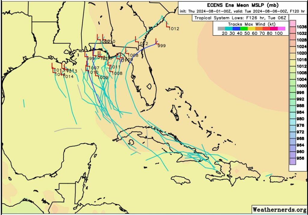
A lack of steering currents
The party doesn’t end early next week, unfortunately. Let’s assume the system moves near the Florida Panhandle by Sunday or Monday. At that point it will run into an atmospheric pattern known as a “col,” not to be confused with the state or military rank. A col, in meteorology, means a place where a trough and ridge intersect. Essentially, due to weak steering currents, this tropical system could spin around and make some wild turns in such an upper air pattern.
For example, the European model brings the center of a very weak tropical system to the Florida Panhandle late next Monday, and then retrogrades the system back over the northern Gulf of Mexico for much of next week. The GFS model brings a strong tropical storm to the coastal bend region of Florida on Sunday, moves it all the way into the Atlantic Ocean off the Carolinas, before bringing it westward all the way back to Destin Florida and then Biloxi, Mississippi, before it finally lifts north on Tuesday, August 13. That’s 12 days from now!
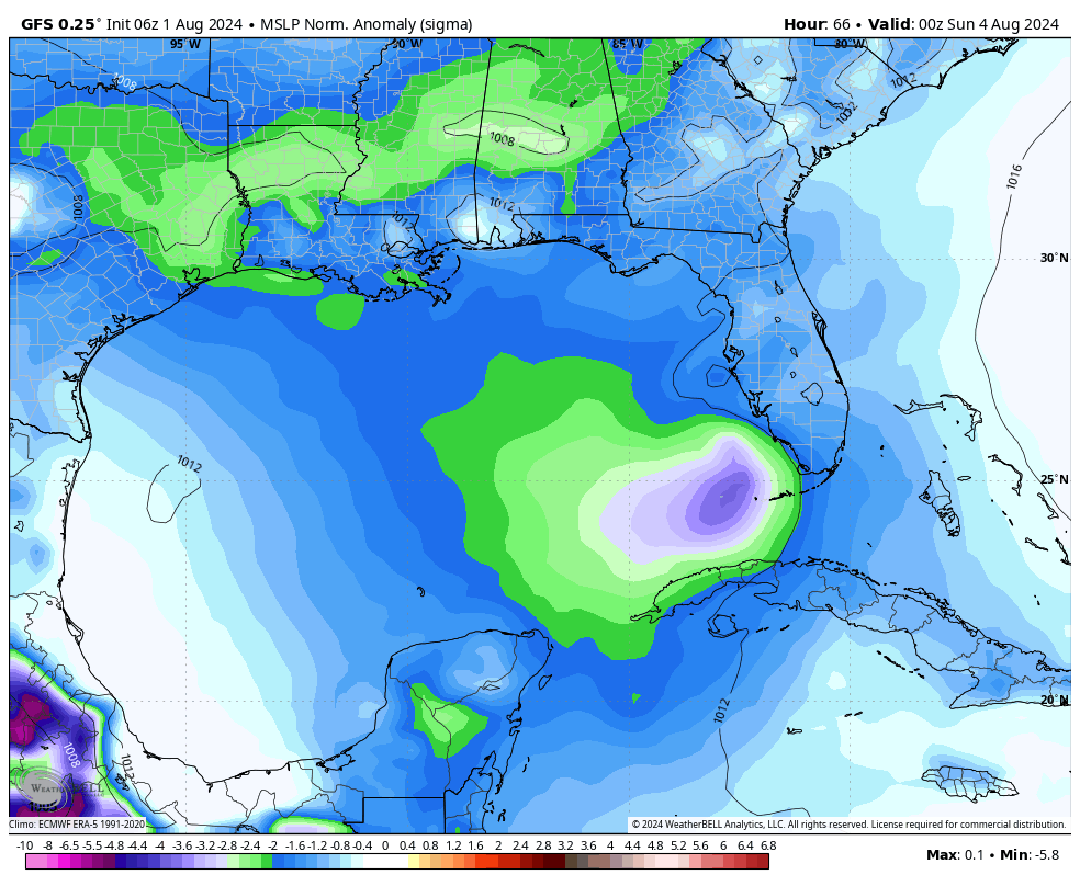
The bottom line is that Florida and the northern Gulf of Mexico coast need to buckle up and be ready for anything over the next week or 10 days. We just don’t know what is going to happen. My biggest concern, for the time being, is the potential for very heavy rainfall along the Florida Panhandle or the west coast of the state. However, as the storm evolves, so will the threats it presents to us.
Good information, Eric. I really enjoy your writing style ⚘
I was hoping we would be told or explained why Texas /Houston / Beaumont is not a threat ?
After Beryl, I’m guessing they don’t want to risk *that* particular egg-on-face unless they’re 100% sure.
High pressure is over Texas
Thank you for the update.
Any thoughts about flight from Houston to Florida, then on to Turks & Caicos on Sunday?
I know it’s too early for exact details, but any thoughts?
You’re seriously thinking of traveling to islands that are six inches above sea level when a tropical system is moving through them?
Yes, but Turks & Caicos will be fine. Its getting there that poses an issue.
Well, if the flights are able to get around the storm, they will.
Hello
Any chance it could drift west and be in our backyard ?
Thanks
Monty
I’m curious whether there’s anything behind it. Some folks scheduled for a trip to the Dominican Republic the week of August 11.
Sitting here watching “Fox 24 Hour Weather” channel.
NHC now designates Invest 97L for the disturbance now at Puerto Rico.
(you won’t see it as such on their Outlook page, because it’s updated every 6 hours (so it’ll be at 2pm EDT).
They spoke with Sr. Hydrologist at NWS Florida (Kelly Godsey) for about 10 minutes about the future potential.
Fox Weather Channel tends to dramatize things. They showed Hurricane Elena’s (Sep 1985) path … how it began with the same track that 97L is on now, then tracking into the eastern Gulf, towards east FL, then did a u-turn and went into MS.
Why are your comments always about what other weather channels your watching?
There’s an old expression: don’t put all your eggs in one basket.
Same thing with investing – diversify!
I do the same with weather predicting. I refer to about six different weather sources, such as SCW, NHC, ECMWF, AWC, NOAA, etc.
Been in the Houston area for almost 67 years (lost a home to Harvey) – I’d rather be over-informed about the weather. It’s good to know if there’s consensus.
What is the AI prediction? It was almost spot on for Beryl.
“what | which” AI prediction?
What is “it”?
Sidenote: when Beryl was predicted to hit Mexico/ Texas border by most , Ventusky site showed Beryl going straight up thru Houston.
.
And it was commented that the model used is traditionally rwong [sic].