It’s a very quiet week nationally, weather-wise, so let’s discuss hurricane season. It’s the time of year where some outlets in the infantile battle of “who called it first” begin releasing seasonal hurricane outlooks. I say that somewhat derisively, but sometimes it does seem like a never-ending battle we fight in this field: First and loudest vs. most prudent.
Did the sizzle fizzle?
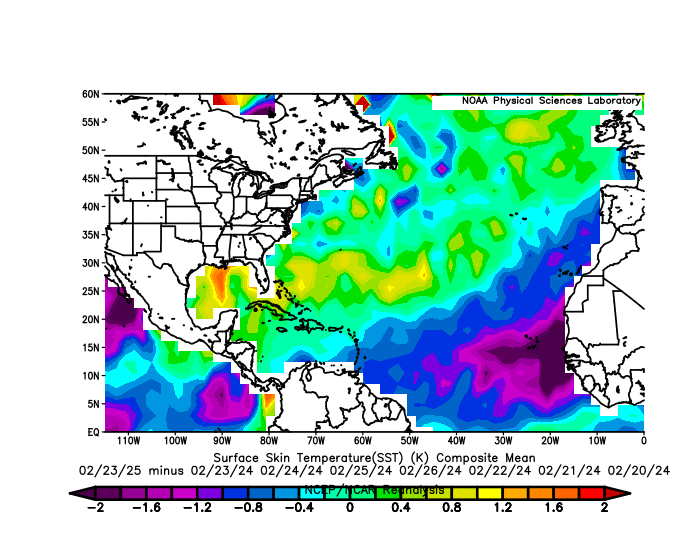
Anyway, the pre-hurricane season season is here now. WeatherBELL, the outlet that said last season would be a “season from hell” is back for 2025, though striking a less foreboding tone. They call for about 15 to 19 named storms, 7 to 9 hurricanes, and 2 to 3 majors. Their idea of a less hostile season is rooted in the cooling of sea surface temperatures in the Atlantic. And indeed, if you compare the most recent available data from February 23rd to the same time in 2024 (with a few additional days added on either side), you can see things have cooled rather considerably between Africa and the islands, or the Main Development Region (MDR).
While we may say “Oh, that’s good, 2025 is way cooler in the MDR!” the reality is that those water temperatures would still be at record levels had we not had 2024 and 2023 happen.
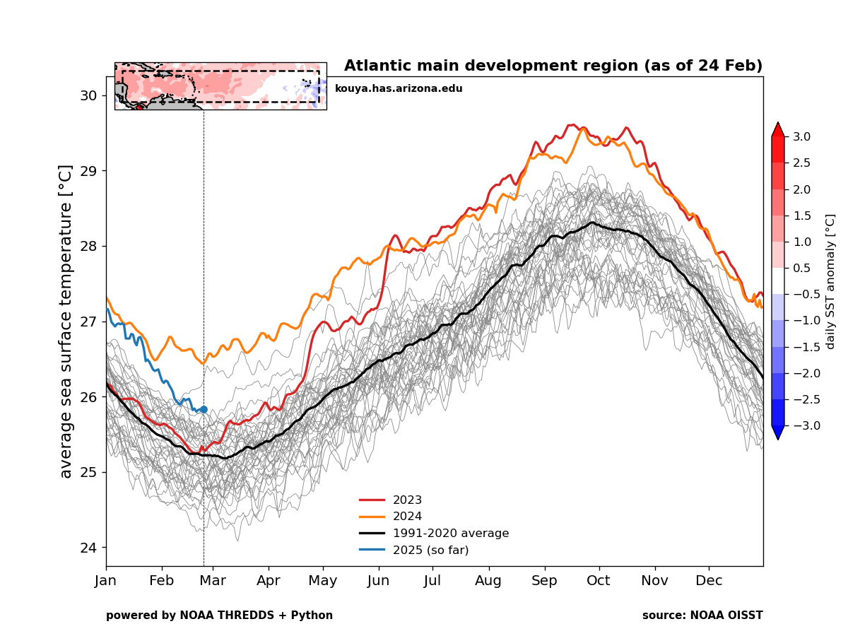
Has the Atlantic’s fever broken? It’s probably too early to speculate a whole lot on that, as what caused it to happen in the first place is still a little bit debatable. So I would refrain from making any grand proclamations about what’s happening out there. Those of us that follow sea-surface temperatures in the tropics closely in the run up to hurricane season know how quickly things can change.
The Gulf and Caribbean are still at or near records, however, which gives anyone living on the Gulf Coast or in the Southeast a little bit of pause. I certainly don’t want to undersell what’s happening there, but it’s only February 26th. A warm Gulf in spring has not been uncommon in recent years. In fact, if you compare the March through May sea-surface temperatures in the Gulf of Mexico over the last 10 years (2015-2024) versus the 10 years prior (2005-2014) to that, you can see a notable warming.
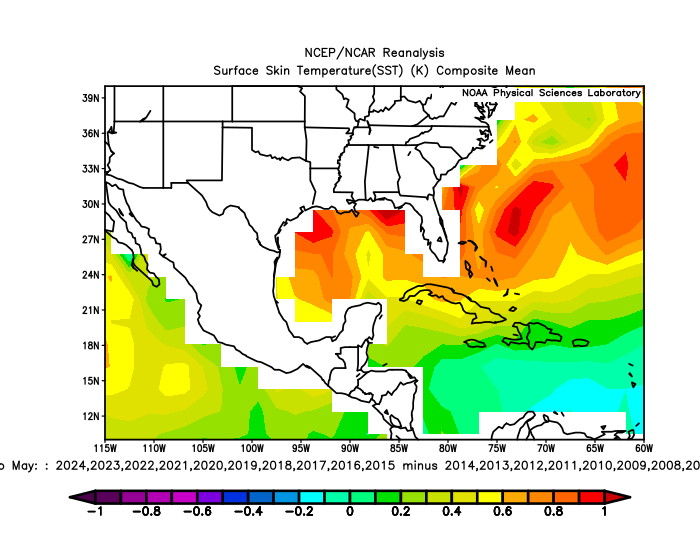
Some of this is likely related to climate change, some of it related to whatever is happening presently with respect to warm global water temperatures, and some of it could be internal variability. The Gulf is slowly warming overall, but no season sees this trend happening more substantially than spring. Most other seasons are averaging about 0.25 to 0.5°C warmer, whereas spring is clearly 0.75° or warmer. My point here: While this is troubling, it’s also not guaranteed to continue at this record amplitude into the meat and potatoes of hurricane season.
So, our Atlantic SSTs are cooler in the MDR, warmer in the Gulf and Caribbean, and much warmer in the northern Atlantic versus 2024.
What of La Niña?
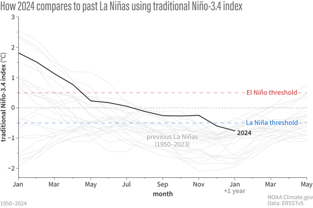
We are currently in a low-end weak La Niña event. Historically, this will end up near the bottom (or “least cold”) of the list of La Niña events since 1950.
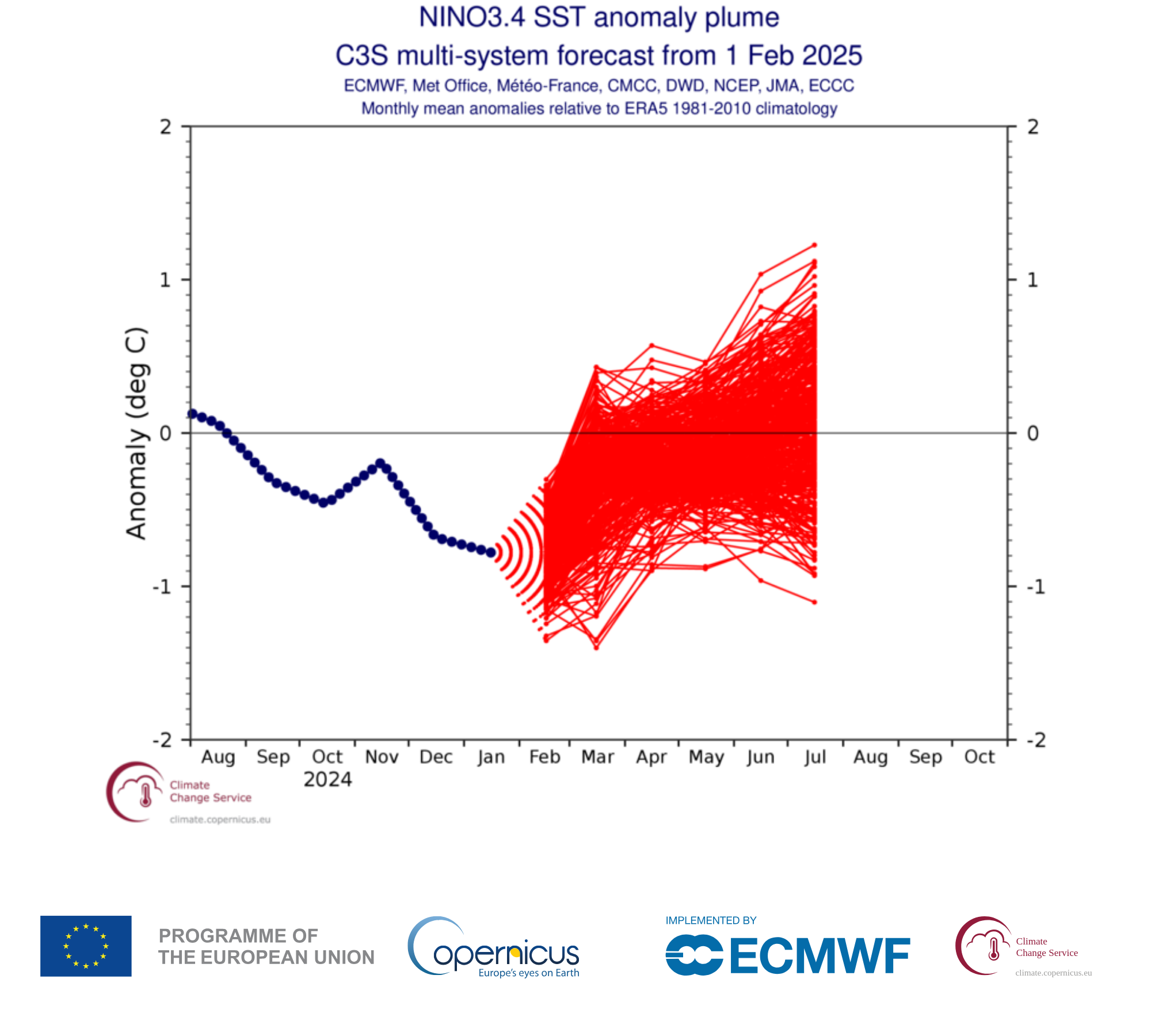
Will we end up seeing a flip to El Niño this summer? Well, your guess is as good as mine. When we look at the EU’s Copernicus program chart of multi-ensemble forecasts for El Niño, we see the several hundred members skew toward an average near zero, which would keep us generally close to ENSO neutral (La Nada) conditions heading into spring. If you want to squint, you may be able to see a 55/45 split toward El Niño over La Niña but that may be presumptive.
Remember, La Niña was expected last summer, and those cooling events in the tropical Pacific are extremely highly correlated to active Atlantic hurricane seasons. That, combined with the raging warm water temperatures led to the catastrophic forecasts last season. This year we are unlikely to have La Niña during hurricane season, though we may end up with limited signal from the tropical Pacific overall. We will still have very warm water temperatures, but they won’t be as doomsday looking as last year.
So putting those points together: Cooler Atlantic SSTs, a weakening already weak La Niña trending to neutral, and I think you have a recipe for what should be above average hurricane season outlooks from anyone issuing them in the coming weeks. However, they will not be anywhere near last year’s numbers. Is that good? Bad? I don’t know; this meteorologist tends to think seasonal hurricane outlooks are not particularly valuable. But the appetite for them is insatiable. Last year’s hurricane forecasts mostly just snuck into the lower end of the verified ranges and the worst-case seasonal forecast outcomes were not even close to being realized. But it ended up being the third costliest hurricane season on record in the Atlantic. So were the forecasts wrong? Or were they right because it did end up being such a bad year even though the numbers weren’t realized? Does it even matter?
Whatever the seasonal forecasters say in the weeks ahead, our messaging here remains consistent: You should prepare for every hurricane season the same way, as if that will be the year the storm comes to you. And as we’ve learned on more than one occasion in recent years, even “weaker” storms can cause dramatic damage. Prepare for the worst, and hope for the best. Much more to come in the weeks ahead on the upcoming season.
Thanks for a well thought out assessment of the situation. It can be difficult to understand how to react when naysayers and climate panicked sources provide information. I appreciate your honesty evaluation and level headed advice. I take it to be “here is our evidence” and “always be reasonably prepared”.
Most of our storms last year seemed to have come from the CAG, not the MDR. I don’t expect a break.
So, those Gulf waters are concerning me. A lot.
Can you help explain that cursed CAG thing? And why it was such an issue last year?
I too find the seasonal forcasts worthless. Weather has so many variables. Just prepare like any other season.
Temperatures both in the air and the oceans can be traced to the Tonga Volcano in 2022. The amounts of water vapor in the air are still elevated from this event. Ignoring it is just plain misinformation. Long live CO2 for the health of the planet…
That’s actually untrue. There is significant debate about why the oceans are so much warmer, and some of it may actually be related more to sulfur pollution rules than Tonga. Tonga certainly has played a role in things to a point. But no one can make an unequivocal statement as you have here. To be clear, CO2 is a greenhouse gas that is primarily responsible for the warming we’ve seen in the last several decades. Ignoring that is just plain misinformation.
Thanks, Matt, for the reasoned early assessment of 2025’s hurricane season.
So thankful to see you referencing Weather Bell. Long before internet, my Mom always listened to Joe Bastardi as he had the most accurate predictions o. The radio. The knowledge he gained from his Dad to study weather patterns to see the cyclic recurrence was spot on. I have shared your website with many friends, keep the facts coming! God bless yall!