In brief: Tropical Storm Jerry has formed and while it isn’t expected to hit land, it may make a close pass to the northeast Caribbean later this week. A coastal storm is becoming more likely off the Southeast or Mid-Atlantic which will likely cause significant marine issues and potentially heavy rain. The remnants of Hurricane Priscilla in the Pacific will deliver copious moisture to the Southwest, potentially leading to heavy rain later this week as well.
Southeast/Mid-Atlantic coastal storm
I want to start today off the Southeast because I feel like this upcoming coastal storm is going to sneak under the radar. Over the next couple of days, a cool front is going to slide south and east,
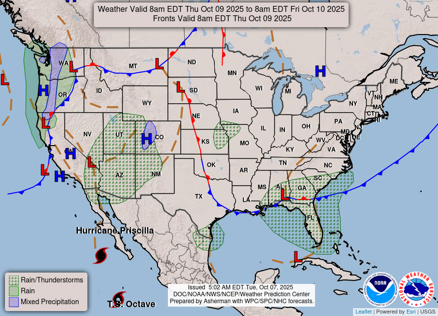
Eventually, all that will congeal off the Southeast coast by the weekend. We should see a coastal storm (non-tropical) develop off the Carolinas. The problem is that there won’t be a whole lot to shove this out to sea. So, for perhaps 2 or 3 days, this modestly strong area of low pressure is going to sit, meander, and spin somewhere off the coast of the Carolinas. Or so it appears sitting here today.
Assuming that happens, there will be issues with high surf, rip currents, tidal flooding (exacerbated perhaps by astronomically higher tides), and gusty winds. The combination could yield further beach erosion for a coastline that has seen quite a bit of hostile marine weather this summer. Interests on the coast from Georgia through New Jersey should monitor the forecast.
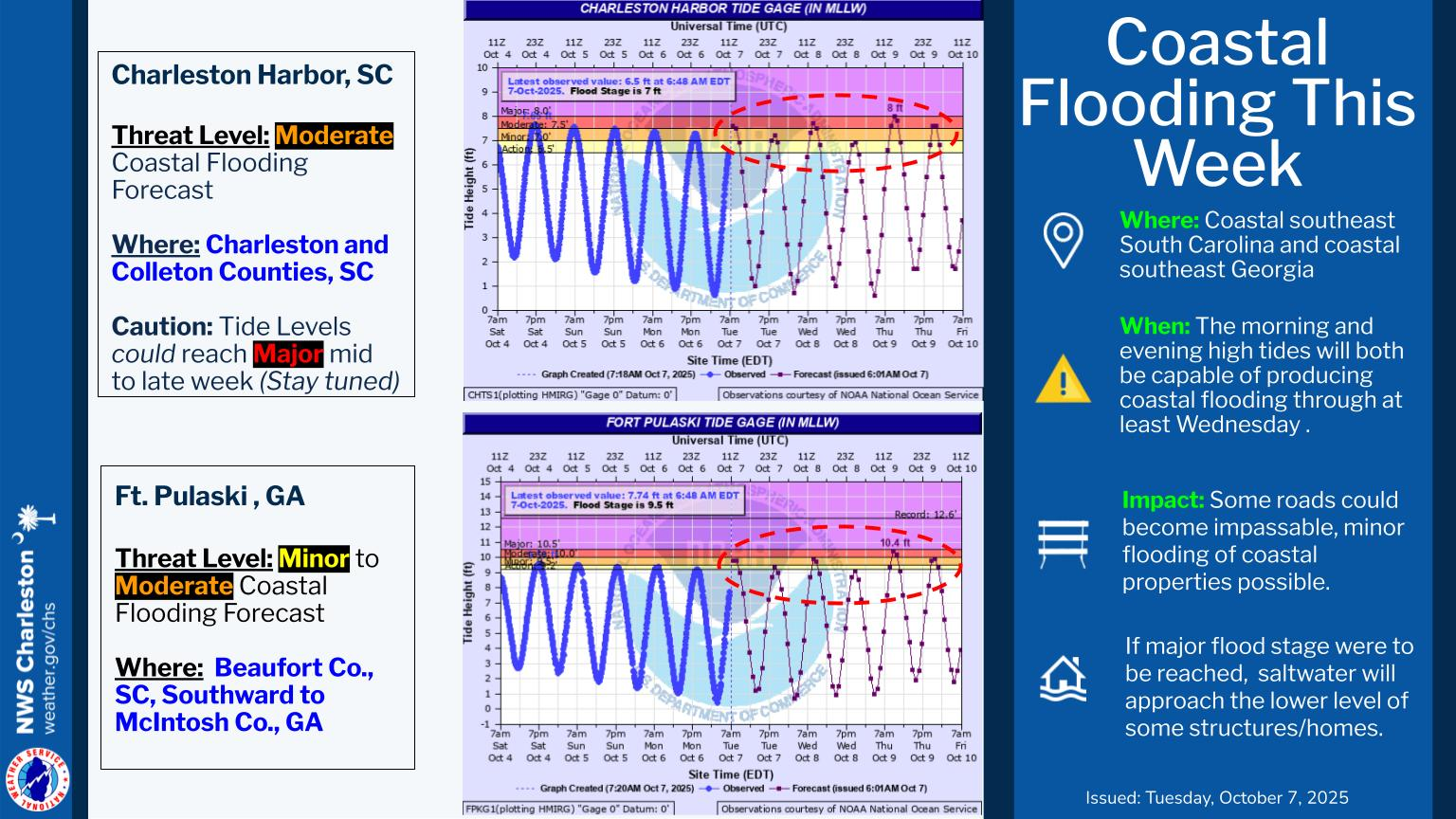
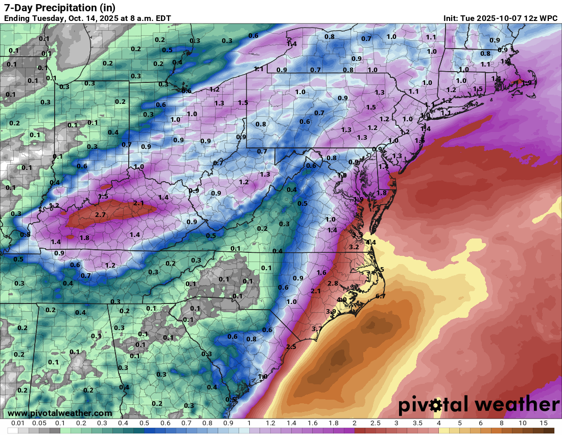
Additionally, heavy rain is possible on the coast from Virginia through the Carolinas. The current rainfall forecast is calling for anywhere from 3 to 6 inches of rain near the immediate coast.
We will keep you posted.
Tropical Storm Jerry
Off to the Atlantic to check in on Invest 95L. Welp, it’s been upgraded to Tropical Storm Jerry, again, bypassing the depression phase and just jumping right in with both feet.
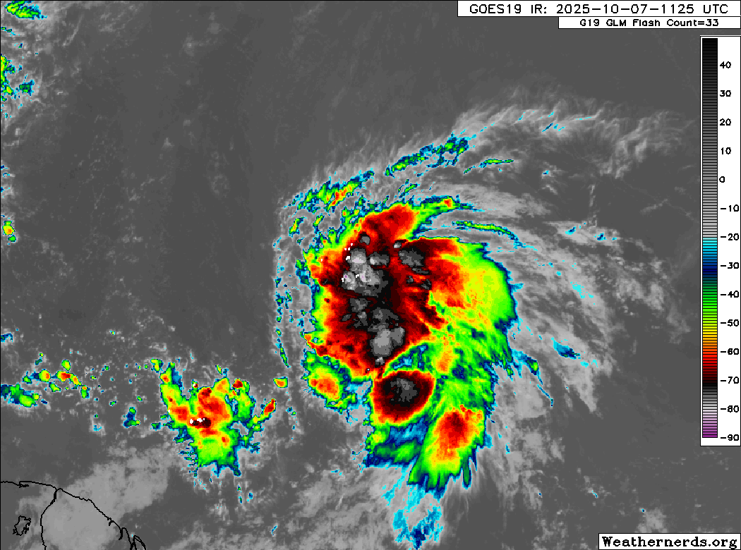
In all honesty, Jerry looks quite healthy, all things considered. This is clearly a tropical storm, and intensification is likely over the next few days. The biggest question is whether Jerry will impact the northeast Caribbean. Since it is intensifying rather quickly, this may help it to gain more latitude a bit faster.
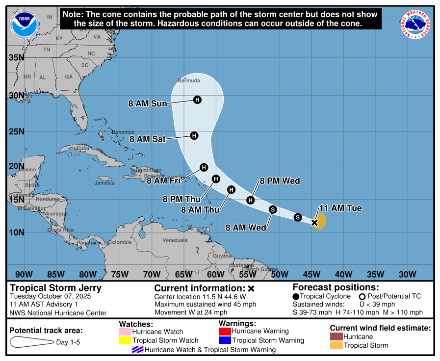
You can see, however, that the NHC’s opening bid on Jerry does keep the cone near or in the far northeastern islands. There are a number of ensemble members from various models that also keep the track of Jerry close to the islands. The majority do curve it north before it arrives, but it will be a fairly close call between the Virgin Islands and Antigua and Barbuda or so. Interests in those areas should monitor Jerry’s progress closely as it approaches by Thursday. I would anticipate that tropical storm conditions would be possible in some of those northeast islands on Thursday or Friday. From there, Jerry should turn north and eventually northeast. The vast majority of guidance keeps Jerry east of Bermuda for the time being.
We’ll continue to watch Jerry’s progress over the next 48 hours as it relates to the islands.

Southwest rain risks increasing
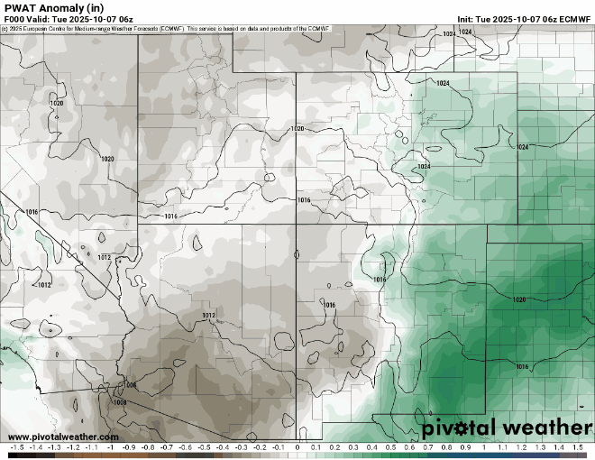
Meanwhile, as the moisture from Hurricane Priscilla in the Pacific gets funneled northward into the Desert Southwest, we will begin to see the potential for some pretty healthy rainfall in the Desert. Places like Arizona into the Four Corners will likely see locally heavy rain. You can see Priscilla’s moisture lunging northward into the Southwest over the next 3 to 5 days.
Flash flooding will be an issue in spots almost certainly as long as this comes to fruition. One notable difference between this setup and the one we saw earlier this season with Lorena that failed to materialize as forecast is that there is a bit less forecast uncertainty with Priscilla. In other words, the option of a hard left turn out to sea is unlikely right now, whereas the system just sitting near Baja as a remnant is more likely. This should increase confidence somewhat in the potential for heavy rainfall in the region later this week. Rain totals continue to trend up a bit, with the latest WPC outlook calling for a healthy 1 to 3 inches across much of the region.
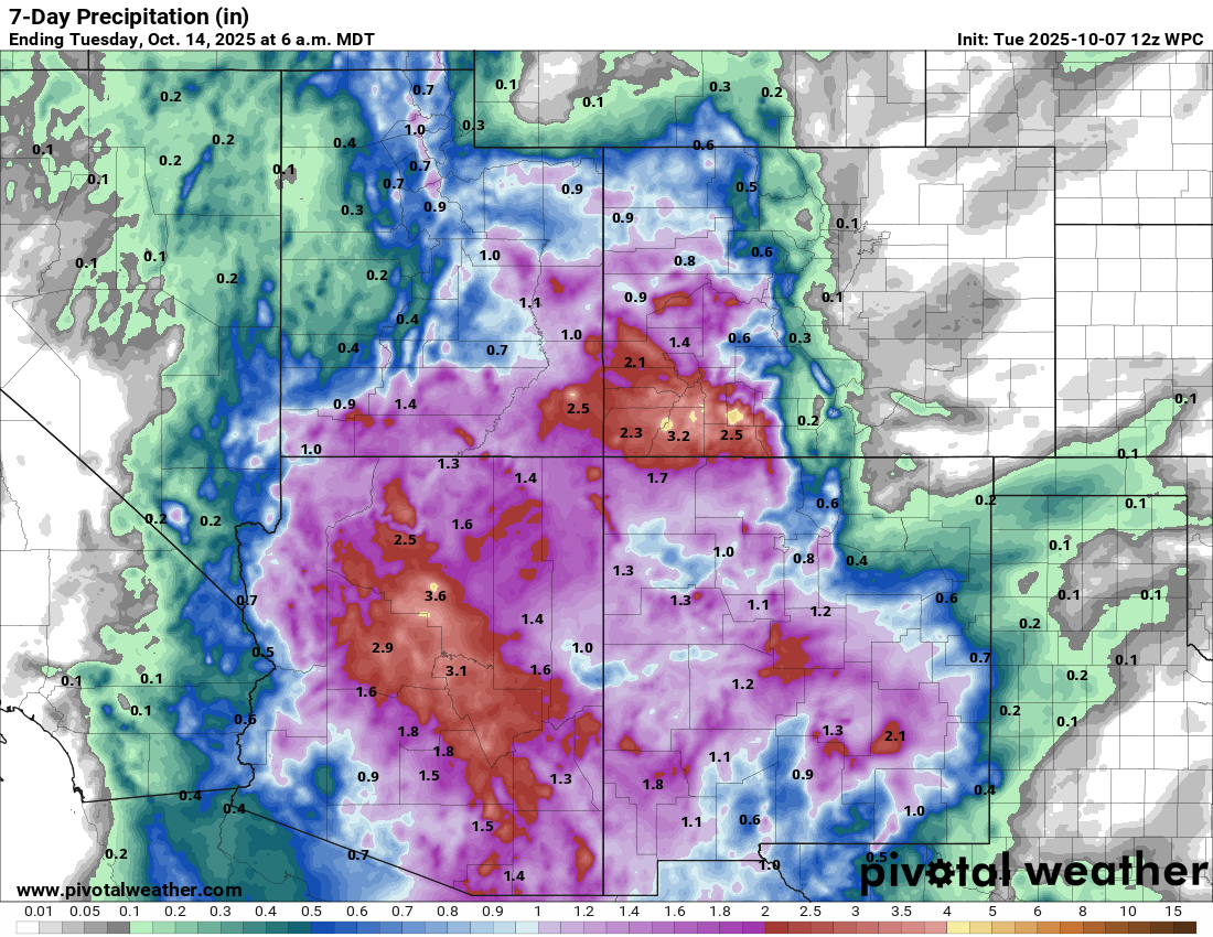
Exactly where the heaviest rain sets up shop and who sees the most will be determined later, but for now, if you have plans to visit the Southwest or you live there, be prepared for some potential disruption due to heavy rains.