Headlines
- Low pressure off the coast of the Carolinas will focus heavy rainfall this week, particularly in eastern North Carolina, along with some coastal flooding and rough seas.
- Tropical Storm Gordon remains well out at sea, of no concern to anyone.
- We continue to see hints that a system may make an effort to develop in the Caribbean after this week, but details remain elusive.
Carolina soaker
Low pressure and an associated trough off the coast of the Carolinas today is flinging rain back into southeastern North Carolina and the Myrtle Beach areas in South Carolina.
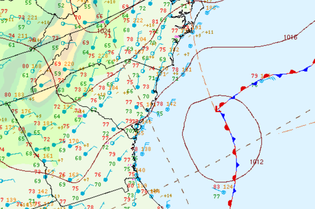
This area of low pressure has an outside chance to form into a tropical entity before coming ashore in North or South Carolina tonight or tomorrow. Whether it does or does not, the impacts should be fairly well baked in right now, which is to say heavy rain, rough seas, some minor coastal flooding and erosion, and breezy conditions are likely in the Carolinas. Depending on the exact track of the storm, we’ll see where the heaviest rainfall sets up.
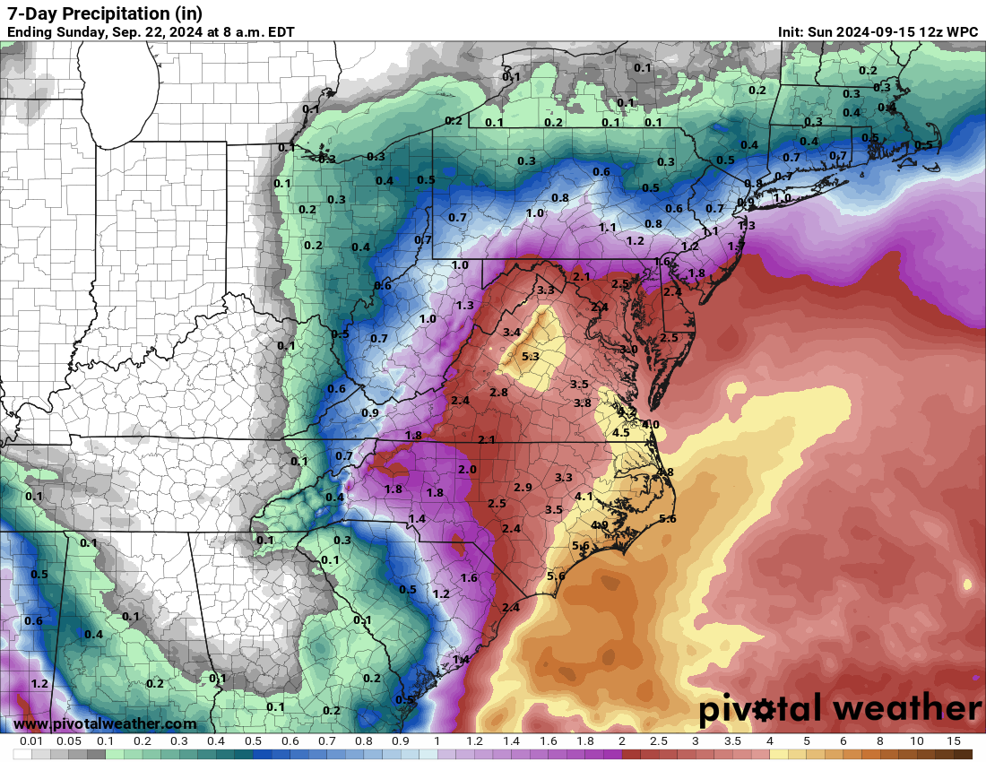
Total rainfall should be highest in eastern North Carolina, where 3 to 7 inches is possible. There will also probably be a localized maximum of rainfall in the northern Blue Ridge in Virginia as well. A large area of moderate rain this week will surround all this from South Jersey into the Triad in North Carolina.
This system will linger onshore for a few days, so it only has about 18 to 24 hours left to formally develop if it does at all.
Deep tropics
Tropical Storm Gordon is likely to get downgraded to a depression soon. It may linger in the open Atlantic for a few days before it perhaps finds a more hospitable environment to reorganize later this week.
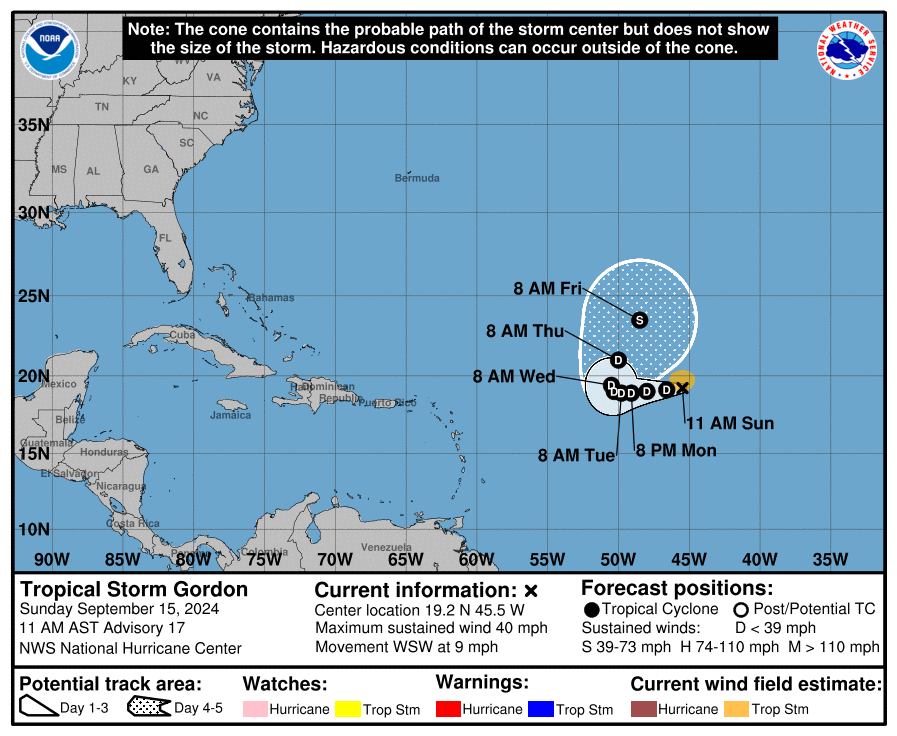
Either way, it will remain out at sea, no threat to land.
Behind Gordon, we have no concerns over the next week or so in the eastern Atlantic.
Caribbean watch
This week will be quiet in the Caribbean as well. However, there continue to be signs and signals that something may get going there after this week. It’s all conjecture at this point, but there’s enough there there to keep us at least paying attention in that region after this week. Not much else to say on this right now. More to come on this through the week though I am sure.
You know, it’s a bit sad to read statements like “Tropical Storm Gordon remains well out at sea, of no concern to anyone” when you can look at AIS data (for example vesselfinder.com) and see quite a few anyones who may well be concerned about a tropical storm. I know that discussions like this are mainly for people who live on land, of course, but the notion of separating the oceans as not being anywhere of interest to anyone is damaging to them in a time of seeking approaches to climate change.
Unless the Captain’s of any nearby ships are completely clueless they can avoid any potential storms. Us landlubbers don’t always have the capability to steam elsewhere.
SCW says high pressure in control around Houston for a week to 10 days. Is it correct that the potential Caribbean development will be just in time for lower pressure to be around Houston?