In brief: A snowstorm is on the way for parts of the Northeast, along with some ice in the interior too. This comes on the heels of a tremendous warm stretch this week across much of the country which led to the warmest Christmas on record in the U.S. However, the warmth will soon fade away as more typical winter resumes.
Northeast snow
En route to the Northeast? A bonafide winter storm. For some of the bigger cities, you’ve been in a bit of a snow drought in recent years.
| City | Last winter with above normal snowfall | Typical average snowfall |
| Boston | 2021-22 | 49.2″ |
| Providence | 2021-22 | 36.6″ |
| Hartford | 2017-18 | 51.7″ |
| New York City (Central Park) | 2020-21 | 29.8″ |
| Philadelphia | 2020-21 | 23.1″ |
| Baltimore | 2015-16 | 19.3″ |
| Washington, DC (National) | 2024-25 | 13.7″ |
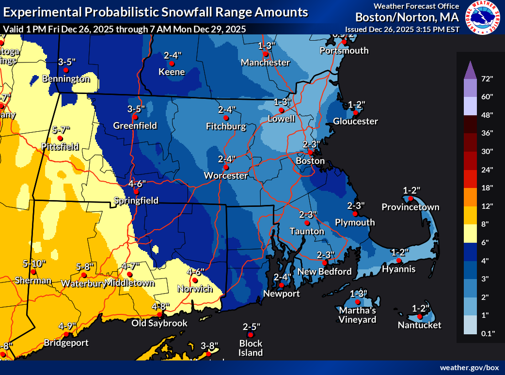
While DC had a (barely) above normal snowfall year last year, prior to that it had been 2018-19. So if you like snow and you live in the I-95 corridor, it’s been a rough stretch since the bounty of the early and mid-2010s. New York City is off to a fairly average start this season with just under 3 inches so far. Philly is the leader so far at 4.2 inches of snow. New England has seen a bit less but not too far off. Enter: tonight.
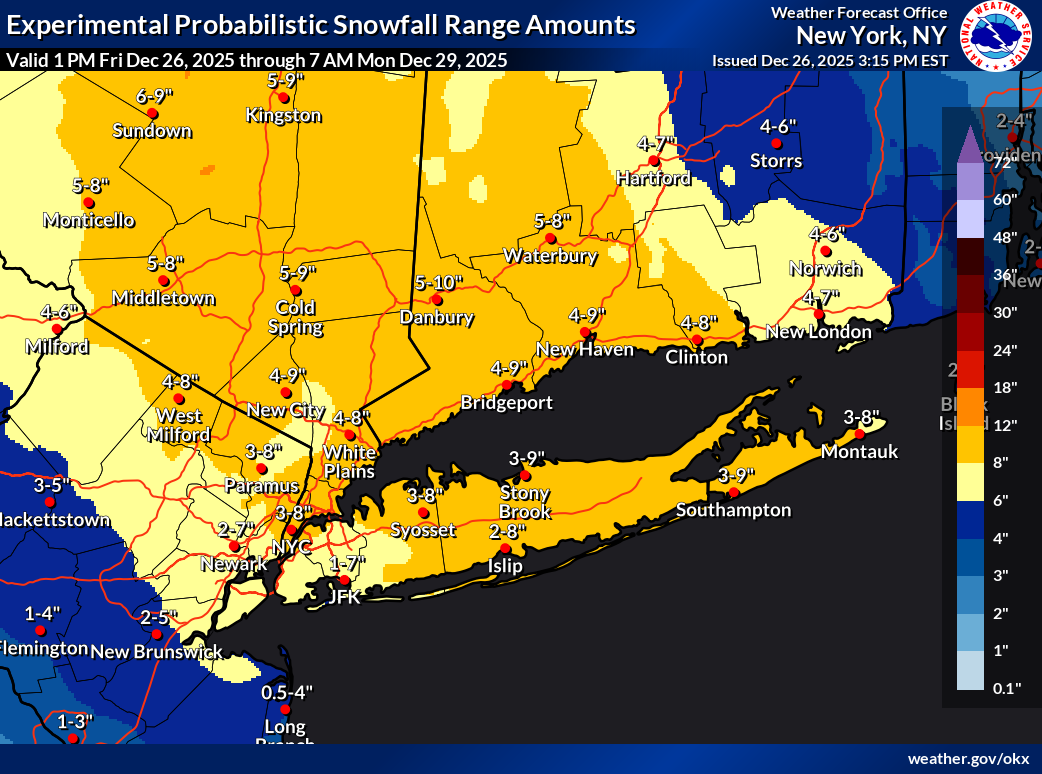
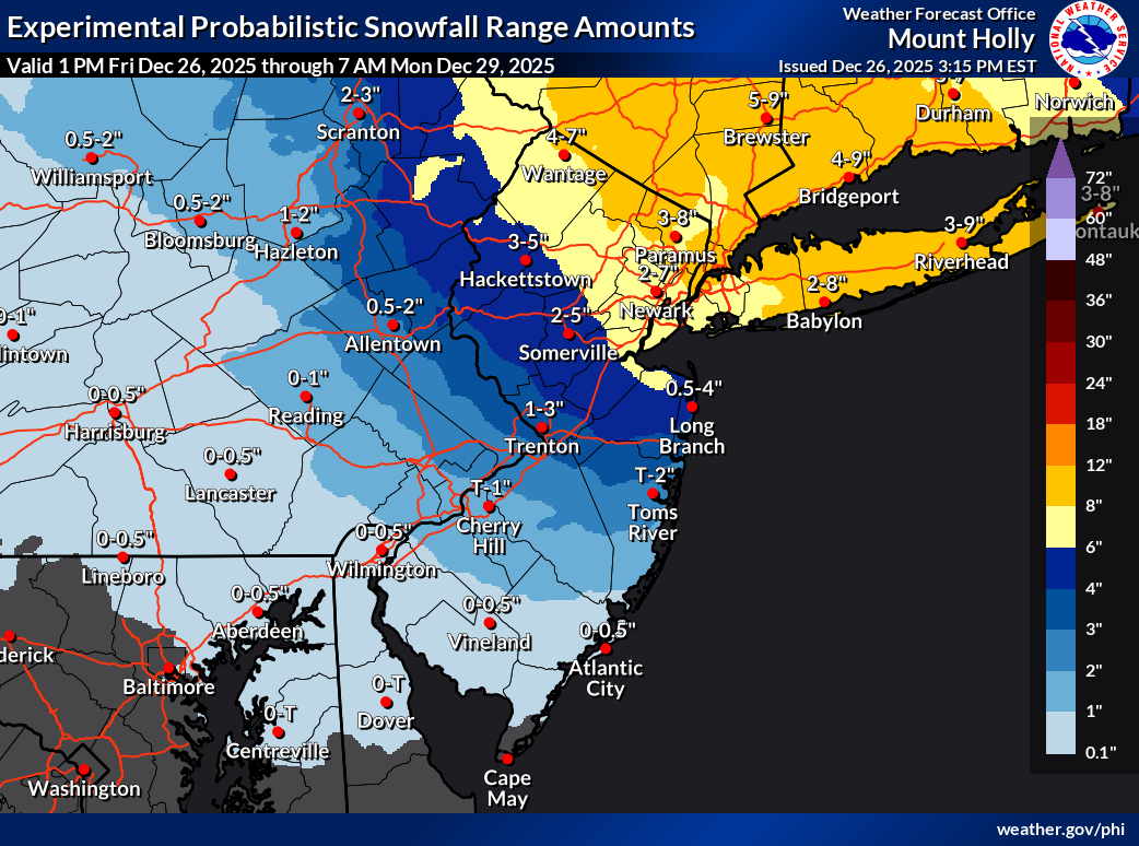
Snow totals should range from about 1 to 3 inches in southern parts of North Jersey to 4 to 8 inches up in Westchester and Fairfield Counties outside of NYC. Not to be outdone, some heavier totals are possible in the Catskills and southern valleys of Central New York.
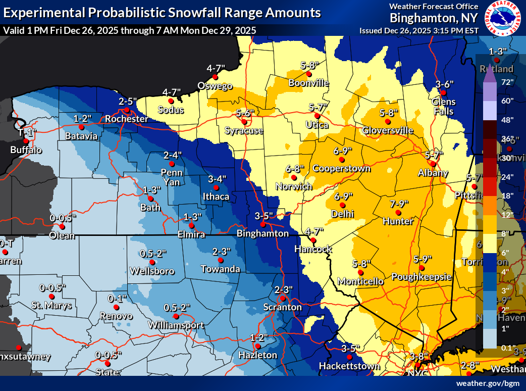
Total snowfall for Syracuse, Utica, and Albany should be around 4 to 7 inches with higher amounts south and southeast and lessening amounts north.
Meanwhile, this will be a bit of a sloppy overall storm as warmer air remains an issue in spots, particularly Pennsylvania where up to 0.3″ of ice accretion is possible in parts of the Allegheny Plateau.
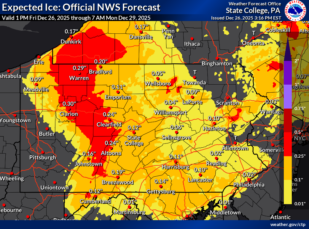
All in all, it looks like a moderately impactful winter storm in most cases, but definitely use caution when traveling, particularly across western Pennsylvania and in the Poconos and Catskills.
Record warmth to subside
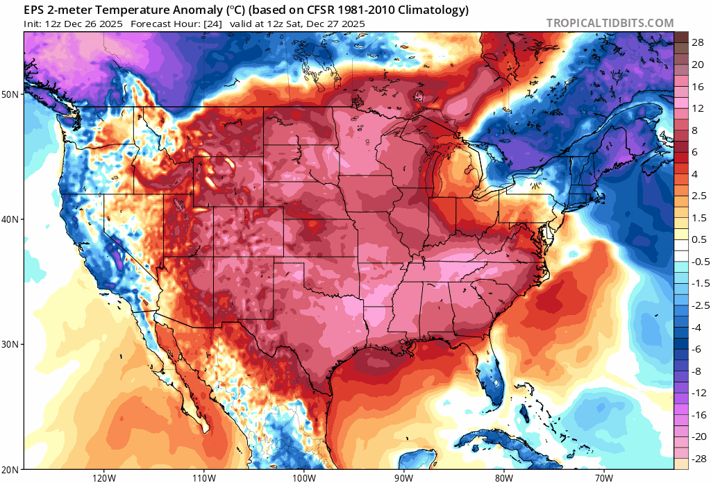
Meanwhile, dozens and dozens of record warm temperatures were broken this week, including many this afternoon.
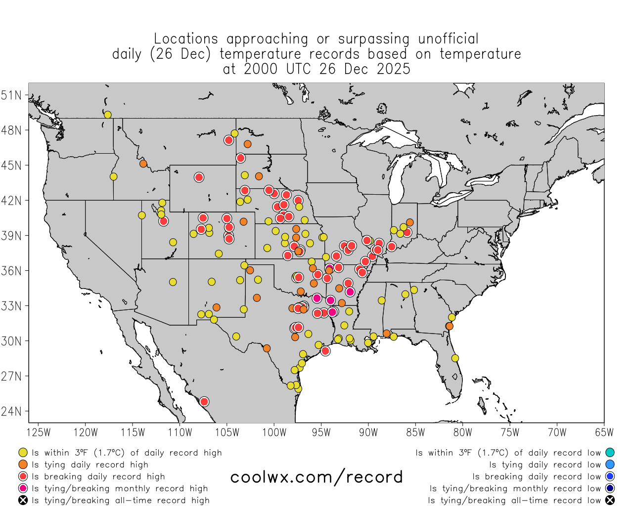
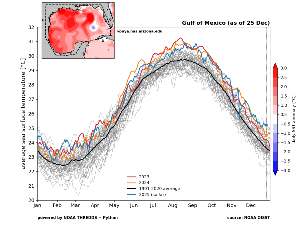
Statistically, Christmas Day was the warmest Christmas on record nationally, and it was not particularly close. Spin it however you want, but this was a historic warm stretch this week across the country. The odds of these kinds of events will continue to increase as time goes on, thanks in part to extremely warm ocean waters, climate change, and urbanization. In fact, take note of the Gulf of Mexico water temperatures. They are, well, the warmest they’ve been on record this late in the calendar year.
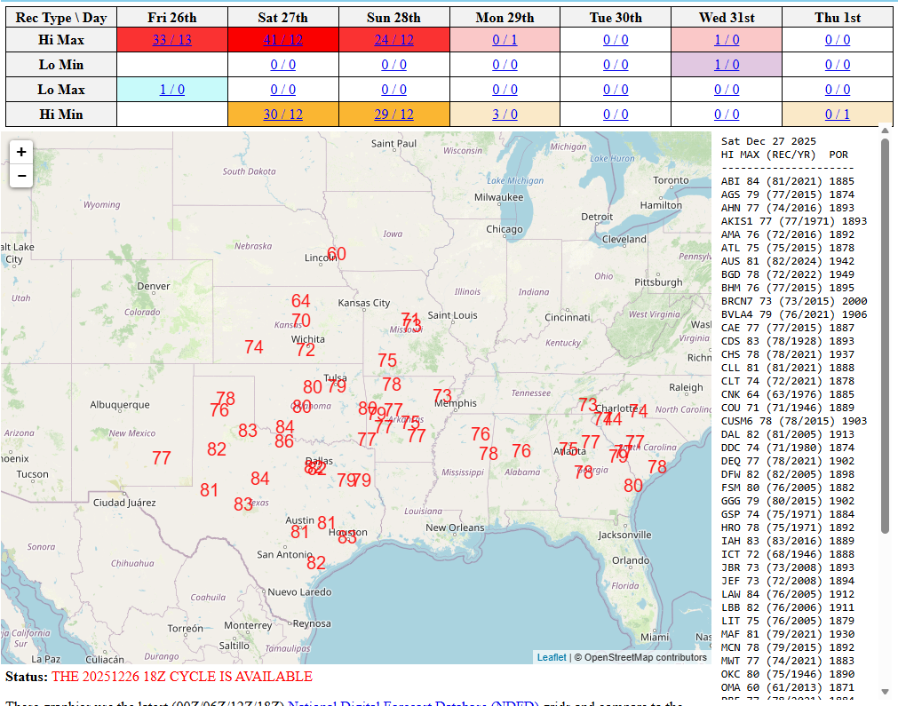
Today isn’t much better temperature-wise. Texarkana is sitting at 84 degrees, a new all-time December record this afternoon. The previous record was 83° in 1955. Shreveport has done the same. Numerous record highs are expected to fall tomorrow as well.
But this warmth will be eradicated by the end of the weekend in most of the country. Note how the extreme warmth gets pushed out to sea by Monday. While there will continue to be some warmer temps in the West and eventually back in Texas, the East Coast and northern tier from the Dakotas through New England look chilly to start 2026.
So, New Year’s week should not be incredibly warm like Christmas week has been. And so it goes.
Newsy bits
Hurricane risks: A paper published by scientists from the University of Georgia and UConn determined that any disaster relief workers responding to the Houston area in the wake of Hurricane Beryl in 2024 were exposed to unsafe heat conditions, particularly for those not acclimated to weather of this sort, 74 to 100 percent of the time in the first 72 hours post-storm. It highlights a crucial need to protect first-responding disaster relief workers in the aftermath of storms. (AGU)
Western Washington: In the wake of recent flooding, the region is going to face a long-term recovery project. Thankfully, disaster aid was approved at the federal level for the state, but for individuals, that aid has not yet been approved. The process will be arduous and challenging at times, and as we’ve noted here, it will require some conversations about how to manage some of these waterways. (High Country News)
Illinois: Another place, another increase in homeowner’s insurance premiums. Allstate announced a premium hike heading into 2026. State Farm did so earlier this summer. All the insurers are citing severe weather events and higher costs for repair and replacement as reasons for the hike. Like most of these problems. it’s complex. (Chicago Sun Times)
Atlantic Ocean: There has been a lot in the news in the last several years about the potential collapse of the AMOC, or Atlantic Meridional Ocean Current, which could drastically shift climate colder across the globe, as has been documented in the past. Ironically, an accelerated pace of global warming could trigger an accelerated cooling via that collapse. To be clear: A lot of unknowns exist. A lot. But it’s enough that Iceland at least has elevated this to a potential national security risk. (Reuters)