Next update will be after the 10 AM CT advisory on PTC 6 Monday. Changes overnight were minimal with a track toward the Louisiana coast, minimal impacts to Houston, and more significant impacts in central Louisiana. PTC 6 is expected to become a hurricane before landfall.
Headlines
- Invest 91L is expected to develop into a tropical storm or hurricane in the western Gulf of Mexico by midweek.
- The track forecast is generally pointed toward the extreme upper coast of Texas or Louisiana.
- Coastal impacts are likely between Matagorda Bay and New Orleans.
- Inland impacts will depend on exact track and intensity, but at this point we do not believe Houston is the primary target of this storm.
- Heavy rain and flooding on the coast is a good possibility.
- Invest 92L in the deep Atlantic is not a land concern at this time.
Invest 91L to likely become a tropical storm or more in the western Gulf
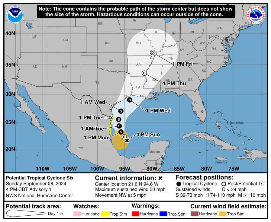
UPDATE (4:20 PM Sunday): The NHC is issuing advisories on Potential Tropical Cyclone 6. Their first map is shown below, which we telegraphed a bit in the post below from earlier.
We continue to watch Invest 91L, which is likely to be upgraded to a potential tropical cyclone this evening by the National Hurricane Center. This will probably mean the issuance of tropical storm watches on the Texas and Mexico coasts.
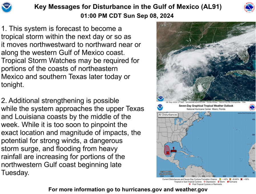
The disturbance continues to produce ample thunderstorms in the Bay of Campeche, but it remains a day or so away from actually organizing into a formal tropical entity.
Look for things to start trying to get in gear later tomorrow.
Track
So where will Invest 91L go once it develops? Some of this will depend on exactly *where* Invest 91L formally organizes. The final track will ultimately be dependent on the intensity which will be somewhat dependent on where it forms, so everything is connected. In general, however, Invest 91L is going to follow the periphery of high pressure centered near Florida.
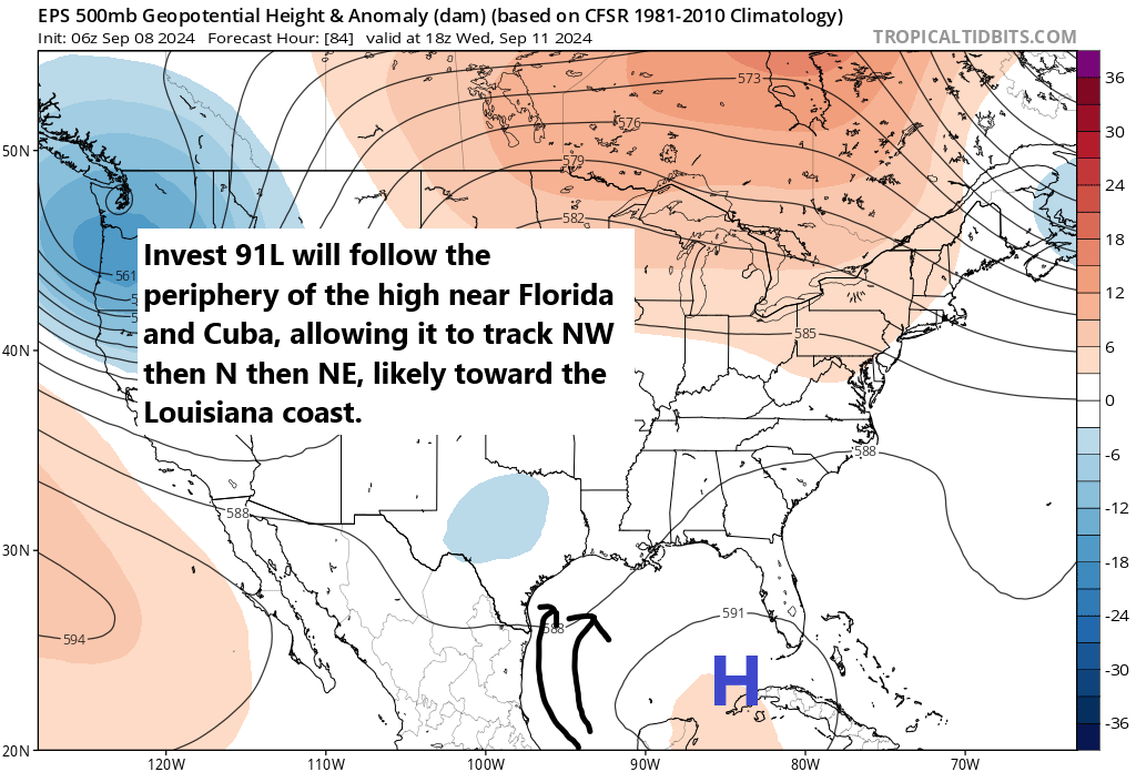
From a forecast perspective, this setup is certainly not without nuance, but it does make the track forecast a little more simple. Initially, 91L will track northwest in the Bay of Campeche. From there, as it organizes, it will begin to turn toward the north. Eventually, it should turn northeast, which, depending on where it forms, puts it on a track likely between Galveston and central Louisiana. Again, there is nuance here in that a weaker outcome would lean left, closer to the Galveston-High Island corridor, whereas a stronger outcome would track a bit closer to Vermilion Bay in Louisiana. But for the most part, I think the track forecast is relatively well understood at a high level today.
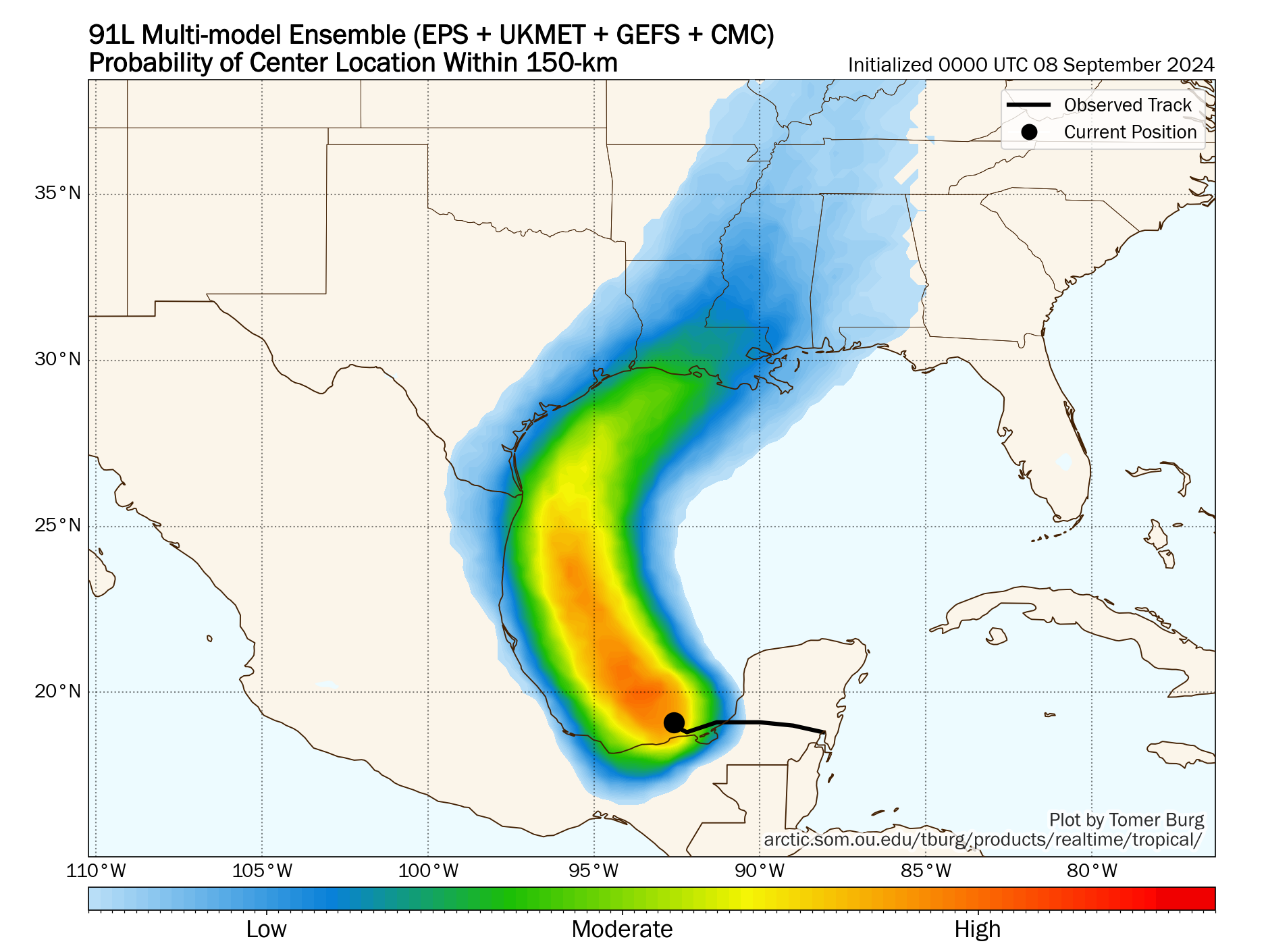
Trends in the last 24 hours have been toward a slightly stronger storm closer to central Louisiana. But there remains a relatively wide berth of possible outcomes. So don’t write it off in Galveston yet, but it is likely that if it hit Galveston directly, it would be a weaker storm.
Intensity
So let’s talk about intensity. Operational modeling has come around to the idea of a more well developed, stronger storm now. Earlier this morning, most tropical modeling was spread between high end tropical storm and low end tropical storm intensity. This afternoon’s runs have tended to bump this up a little, ranging from weak tropical storm to hurricane intensity. SHIPS guidance, which forecasts the odds of rapid intensification suggests about a 6 to 8 times greater than normal potential of this rapidly intensifying in the next 72 hours. Wind shear looks low, and while sea-surface temperatures are not ballistically warm in the western Gulf, they are at or above normal away from the immediate coastline and more than supportive of intensification. It appears the environment will be favorable for intensification.
Based on all this, we are likely heading for at least a moderate to strong tropical storm and a reasonable chance at a hurricane assuming this tracks as shown above toward Louisiana
Impacts
Obviously, we’re going to be concerned with tropical storm or hurricane impacts near and especially east of where this comes ashore, which I won’t try to pinpoint exactly right now, but they’re primarily on the Louisiana coast at this time. We will cover that in more detail tomorrow as more becomes known with respect to track and intensity. We should expect waves of 10 to 20 feet offshore with this as it comes north. Gusty winds will occur on the coast between Matagorda Bay and Sabine Pass in Texas, possibly up to tropical storm intensity (35 to 45 mph). Inland locations like Houston should see much less of that. And again, Louisiana will likely see stronger winds. If the storm comes in at Galveston or High Island, there will be stronger winds in the Beaumont-Port Arthur area.
One of the bigger impacts with this storm will likely be rainfall. Somewhere will likely see 10 to 15 inches of rain from this storm with widespread amounts a little under this elsewhere. For Texas, with a track more to the east, this has generally lowered rain totals there. However, that has led to higher totals in parts of Louisiana. The map below shows the European operational model’s forecast of rainfall. Normally, I don’t care to show operational model guidance rain maps, but I think this is a decent representation of risk. The highest totals will be along track and to the east, but the entire coast, even west of the landfall point should see at least some heavy rainfall.
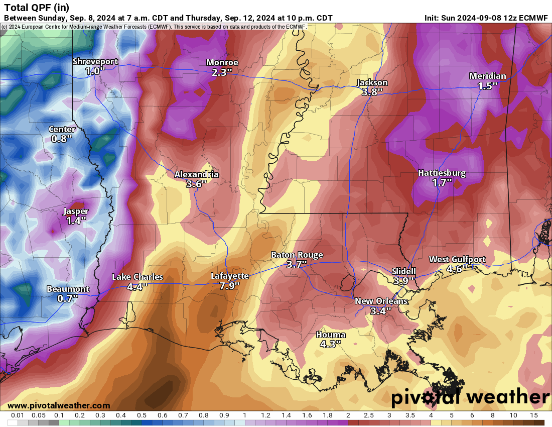
I expect flash flooding to be a concern in Louisiana, which has seen a good bit of rain lately, as well as in southern Mississippi and Alabama. Coastal Texas will be dependent on exact track, but flooding risk doesn’t look overly concerning right now. Still, check in on this again to see if anything’s changed.
Storm surge will also be an issue, but we will await guidance from the National Hurricane Center on that before speculating. And as always, tropical systems can and do produce isolated tornadoes.
At this point, interests on the Texas and Louisiana coasts should continue paying close attention to the forecast updates on Invest 91L or the potential tropical cyclone. The biggest concerns right now are for Louisiana, but continued monitoring is advised in Texas too. More either tonight or tomorrow morning.
Invest 92L
Meanwhile, way out in the middle of the Atlantic, we have Invest 92L, which has 70 percent odds of developing in the next several days.
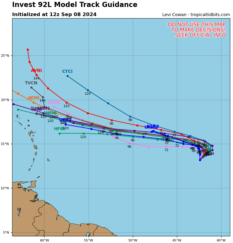
This one will take a day or two to start organizing, but once it does it should track west-northwest, likely strengthening slowly before turning more northwest later this week, probably staying out at sea. For now, interests in the Caribbean islands should keep tabs on this, but it is not currently expected to deliver significant impacts there.
Beyond 92L, we have another wave likely to emerge off Africa later in the week that could develop out at sea in the eastern Atlantic. But there are no other land concerns besides Invest 91L at this time.
Great as always. Anything on the timing of possible impacts from 91?
Tuesday rain possible south to north. Wednesday primarily for storm impacts, maybe the first half of Thursday in Louisiana too.
Appreciate the Sunday update !
It seems like the Atlantic is trying to catch up on lost statistics – let’s hope not.
I just checked the NHC website. The system (to quote), “we have another wave likely to emerge off Africa later in the week that could develop out at sea in the eastern Atlantic” (the one trailing AL92, which is at 60 percent | 70 percent) …
That system is now (already) “0 percent in 48 hours, 50 percent in 7 days”. Seems the potential for that one is probable, but thankfully shows a northerly path.
Fingers crossed 91L continues the projected ‘east of Houston area’ path.
Two questions. First, scheduled to fly into IAH at noon Tuesday…. Is this ahead of the worst rain in Houston? Second, on the 10 to 15” of rain: are there credible scenarios where Houston gets this?
Thank you for the updates…Grrrr, this year is weird.. It seems like whenever we have a storm that seems like it may landfall close to us, we don’t get high confidence info to swing into gear or draw a sigh of relief until 24 hours or less before these storms actually hit..But I know, we should always be prepared..
But it’s hard for many people (financially)to stay extremely well prepared to the extent that they feel safe riding out a high end storm in their homes…
The NHC has now labeled it “Potential Tropical Cyclone Six”.
And when you click on its “X” on the 7 Day Gulf map, a new page is displayed with the ten typical graphs they show for cyclones and hurricanes.
The Fox 24 Hour Weather channel (26.3 and on the web) have increased their discussions about it.
Got a girl, her name’s Francine
Finest thing you ever seen
And I love her, she’s all that I want
And I need her, she’s all that I need
Well, Francine, oh Francis, why
Do you love me and make me cry?
How I love her, she’s all that I want
How I need her, she’s all that I need
What are the likely impacts on the 91L storm from the cool front and dry air?
I don’t get why the GFS is showing essentially nothing there on the 10/11/12th, yet does show something in the Gulf a week from now.
Is there some other trouble area that wants to develop in the BOC next week?
Seems like you’re looking at bad data. It’s definitely there on the model this week. Quiet next week.
Whew – thanks
Just checked NHC website … we NOW have Francine in the Gulf !? 👍