Headlines
- Beryl’s track forecast narrows a bit on the Texas coast; still expected to make land as a hurricane Monday.
- Beryl trying to put itself back together, but has a ton of dry air to battle over the next 12 hours.
- Flash flooding and isolated tornadoes likely across east Texas on Monday.
- Hurricane preps should be in full swing between Corpus Christi and Galveston.
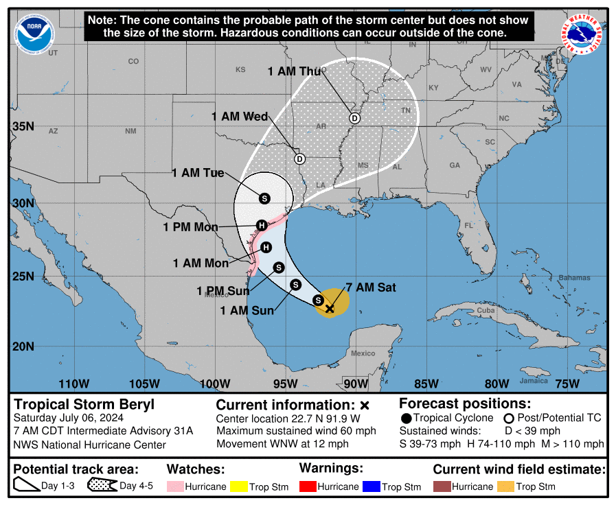
Tropical Storm Beryl (60 mph, WNW 12 mph)
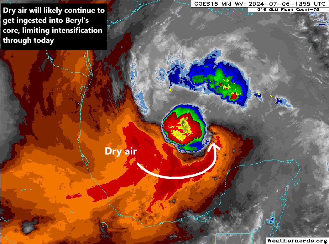
After trekking a chunk of the Yucatan, Beryl devolved into a mess overnight with dry air wrapping into the storm on the south side. As of the last 2 to 3 hours, however, Beryl is beginning to effort reintensification over the Gulf of Mexico.
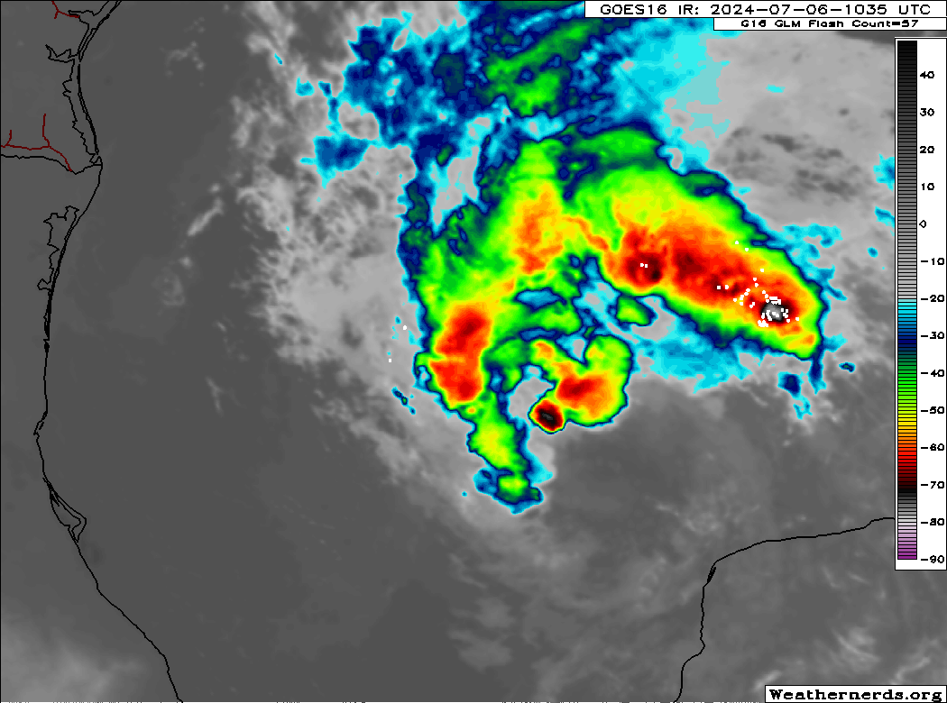
Although the rebuilding process is now underway, looks can be deceiving. If you look at water vapor imagery, just to check in on what type of air surrounds Beryl, it’s kind of ugly, indicating a lot more dry air for Beryl to have to shrug off. Intensification should be slow through today.
Since yesterday evening, modeling has tended to stop the rightward progress of the track adjustments, reassuring for Houston in a way, but we’re now sort of narrowing into a window between about Baffin Bay and just east of Matagorda Bay in Texas for ultimate landfall. Keep in mind that while the landfall point is important for elements of the storm, like surge and the strongest of the wind, the storms impacts will extend well out from the center, particularly as Beryl grows into a slightly larger storm spatially in the Gulf.
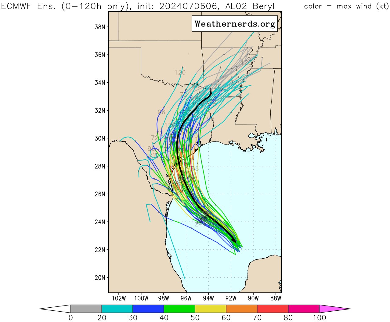
You can see the 51 member European ensemble above with a few members into Houston and the rest spread out south toward Matagorda and Corpus Christi. We are about 36 hours from landfall and because of the turn and angle of approach to the Texas coast, there is still a healthy spread here that will have impacts on who sees the worst of the surge, wind, etc. Basically, folks from Corpus Christi through Galveston should be preparing still for a hurricane impact.
Speaking of impacts, I will direct folks interested in the Houston area to our Space City Weather site where Eric has a good bit of detail on exactly that this morning.
For folks farther down the Texas coast, in Corpus Christi, it will be a close call. We still expect that despite slow intensification today, Beryl will try to make a last second run at it in the 6 hours or so leading up to landfall. This should push it over the edge to become a hurricane. If Beryl struggles more today, it may begin to deviate a little more to the left, putting a hit on Corpus back in play. Beryl’s intensity at landfall will almost be entirely contingent on how much it is able to accomplish in the final 6 to 10 hours or so leading up to that point. For now, expect a category 1 type storm, with risk of a category 2, though I will say some of this dry air may really help us here. But if you are preparing, do so for the worst possibility, which would be a cat 2 in this case.
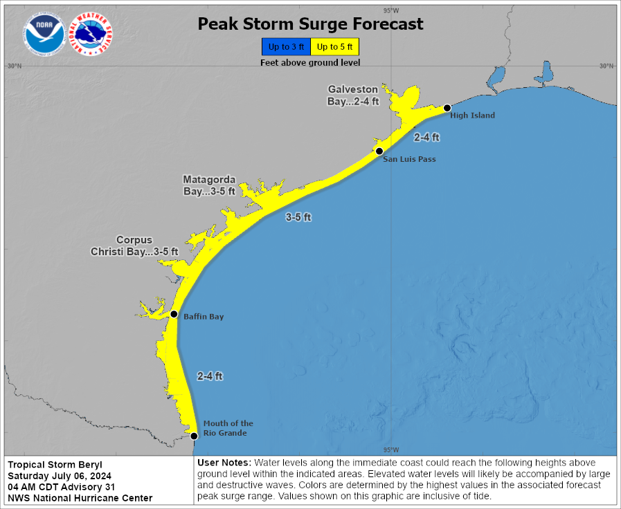
Surge values of 2 to 5 feet are expected on the Texas coast. For many folks this will be about what we saw in Alberto last month. Nearer to the landfall point, this will be worse than Alberto. Again, it’s important to recognize that the impacts of the storm spread far from the center, but there are elements of the storm that do really depend on the exact landfall point.
The best news since yesterday in my opinion is that Beryl’s track through Texas, while slow is faster than it looked 48 hours ago. This places a bit of a ceiling on rain totals. However, there will likely be flash flooding concerns from Corpus Christi through College Station and over to Houston. The flash flood threat may extend all the way up into North Texas, mainly east of I-35 and east of Dallas. It may also extend farther west, closer to the eastern fringe of Hill County, Austin, and San Antonio as well. Folks inland across Texas will want to monitor this closely, particularly those in flood vulnerable areas.
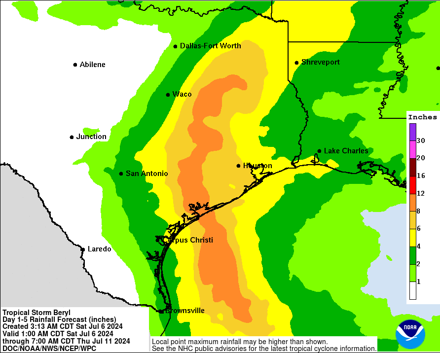
For Texas, the worst of the weather will be later Sunday night into much of Monday, with a gradual improvement from southwest to northeast across the state on Tuesday. In addition to the rainfall, isolated tornadoes are likely Monday near and east of where the center of Beryl tracks.
We will have another update for you later this afternoon or evening with the latest track changes and impact updates on Beryl.
We will post a bit on Twitter/X today and look for a 90 second video update on Beryl on Instagram and TikTok in a bit.
Thank you!
Spicy beginnings to this hurricane season
Thank you for all you’re doing! Hard predications for sure. Super appreciate you guys!
Suppose to head to Branson Monday morning. Should I consider leaving Sunday afternoon to avoid rain? Not sure if rain will impact US 59 North. Good news is I’m leaving town. Thanks.
When you say tornados, I get you mean near the eye, but what about the outer rain bands?
I specifically asking about Spring/S Montgomery county. We lost parts our roof twice in those May winds.
Can you please clarify about where the tornados have the highest probabilities of being up North?
The satellite loop currently shows a lot of thunderstorm activity well to the northwest of the storm’s center. Will that continue as Beryl gets closer to land? Assuming landfall on the central Texas coast, is it likely that Galveston and Houston will see heavy rain from these bands?
Thanks for the great analysis, Matt and Eric.
I’m interested in y’alls opinions or thoughts on Beryl making landfall as a CAT1 or even TS and turning SE TX and Houston area into a Harvey situation as far as the rainfall totals? What conditions would cause this storm to create training bands of rain?
I’m in Corpus. Has there been any change in path since this morning?
I’m in Houston I been telling my daughter we r due for one well here it is u all be careful and stay safe blessings.