In brief: Today we have some commentary on a developing story, where the Trump Administration is planning to dismantle one of the premiere atmospheric research centers in the world. Also, we focus back in the West, where more atmospheric river problems lie ahead.
National Center for Atmospheric Research
I want to start today’s post with a quick note on a story that broke yesterday evening. USA Today reported (and OMB head Russ Vought confirmed) that the Trump Administration would direct the National Science Foundation to dismantle the National Center for Atmospheric Research, or NCAR. The plan is to fully close the historic Mesa Lab in Boulder, CO.
I cannot begin to tell you what a bad, bad, bad decision this is. Objectively so. This will absolutely cripple and devastate weather research in the U.S. While the administration claims that NCAR is “one of the largest sources of climate alarmism in the country,” (it isn’t) almost any climate and weather research done in this country is underpinned in some way, shape or form by NCAR. The administration also claims that vital weather research activities will be “moved to another entity or location,” which seems a bit sus to me given many examples of them causing chaos by dismantling things without adequate replacements or contingency plans. But it also completely misses the forest for the trees. The reason the work done by NCAR has been so critical and important to the science and to industry (and thus the American people) is because of NCAR acting as a (very effective) cog in the weather enterprise wheel. This needlessly breaks up an organization at taxpayer expense for no other reason than they don’t like it. NCAR is not an inefficient organization, nor do they do anything but advance atmospheric science research. In other words, there’s no real value derived by anyone in dismantling the organization.
Just as a slight relevant example from my recent past, and this is something that happens a lot all around the country. At a previous job, we sent another meteorologist to NCAR to take part in a discussion forum with leaders from both there and in the field at large to learn and discuss ways we could incorporate machine learning techniques to potentially improve seasonal or sub-seasonal forecasting (S2S). It would be important to note here that both seasonal and sub-seasonal forecasting is very much a climate-related research topic. Grant proposals, 16-to-45-day models, etc. will use the word “climate” to describe the research here. Nothing about that work is involved in climate change. Since the Trump administration gets uncomfortable about particular words and phrases, they probably see “climate” and assume the worst, when in reality a lot of the “climate research” is actually working to help improve forecasts for the economic and societal benefit of the country — not for pedaling alarmism. Go figure. Meetings like these happen a lot, and it ultimately leads to economic and human benefit, as well as uncovers new avenues of research to travel down.
Anyway, suffice to say, this is a terrible decision that will have significant negative consequences for the country and the economy over the long-term, long after these people leave office. That’s why I am writing about it here. Two organizations within government atmospheric research would be devastating to lose, not that others would not but these two are particularly critical: NOAA’s OAR (Office of Atmospheric Research) and NCAR. The Administration has now tried to gut or is in the process of gutting both of them at zero meaningful taxpayer savings and plenty of meaningful negative consequences for the American public and economy. I must question how that fits a so-called America first agenda.
On to the weather
The big story over the next several days into next week will be another atmospheric river event on the West Coast. Note that NCAR does work to support atmospheric river reconnaissance research that helps improve forecasts of these events. This event is taking aim at the Pacific Northwest right now, where we have numerous watches and warnings posted for flooding (thankfully not as bad as last week), heavy snow, blizzard conditions, and strong winds. In fact, the footprint of wind advisories and high wind warnings is tremendous, extending from the Northwest into the Northern Rockies and Northern Plains.
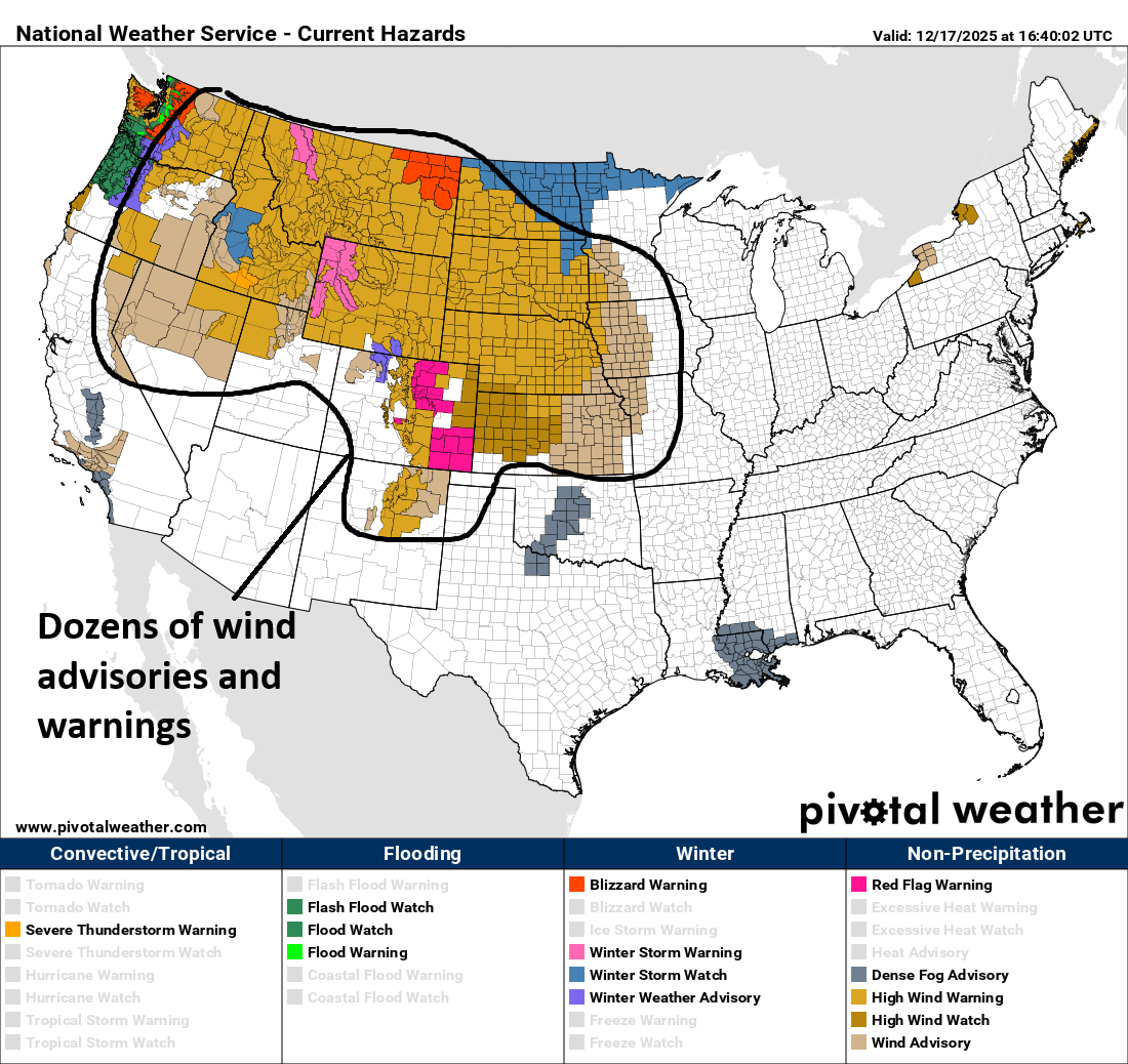
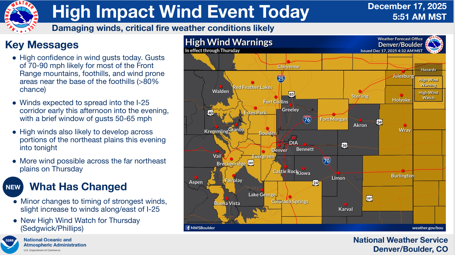
One specific area to watch closely today will be the Front Range in Colorado where gusts of 70 to 90 mph will be possible in the higher terrain and wind-prone bases of the foothills. Winds could gust as high as 50 to 60 mph in the Denver area as well later today.
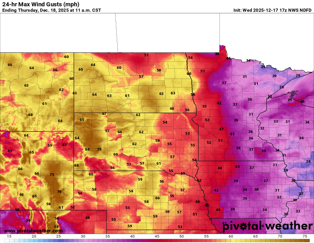
Wind gusts on the Plains will be nothing to sneeze at either, with widespread 50 to 70 mph gusts in the Dakotas, Montana, and Wyoming, along with stronger winds at higher elevations.
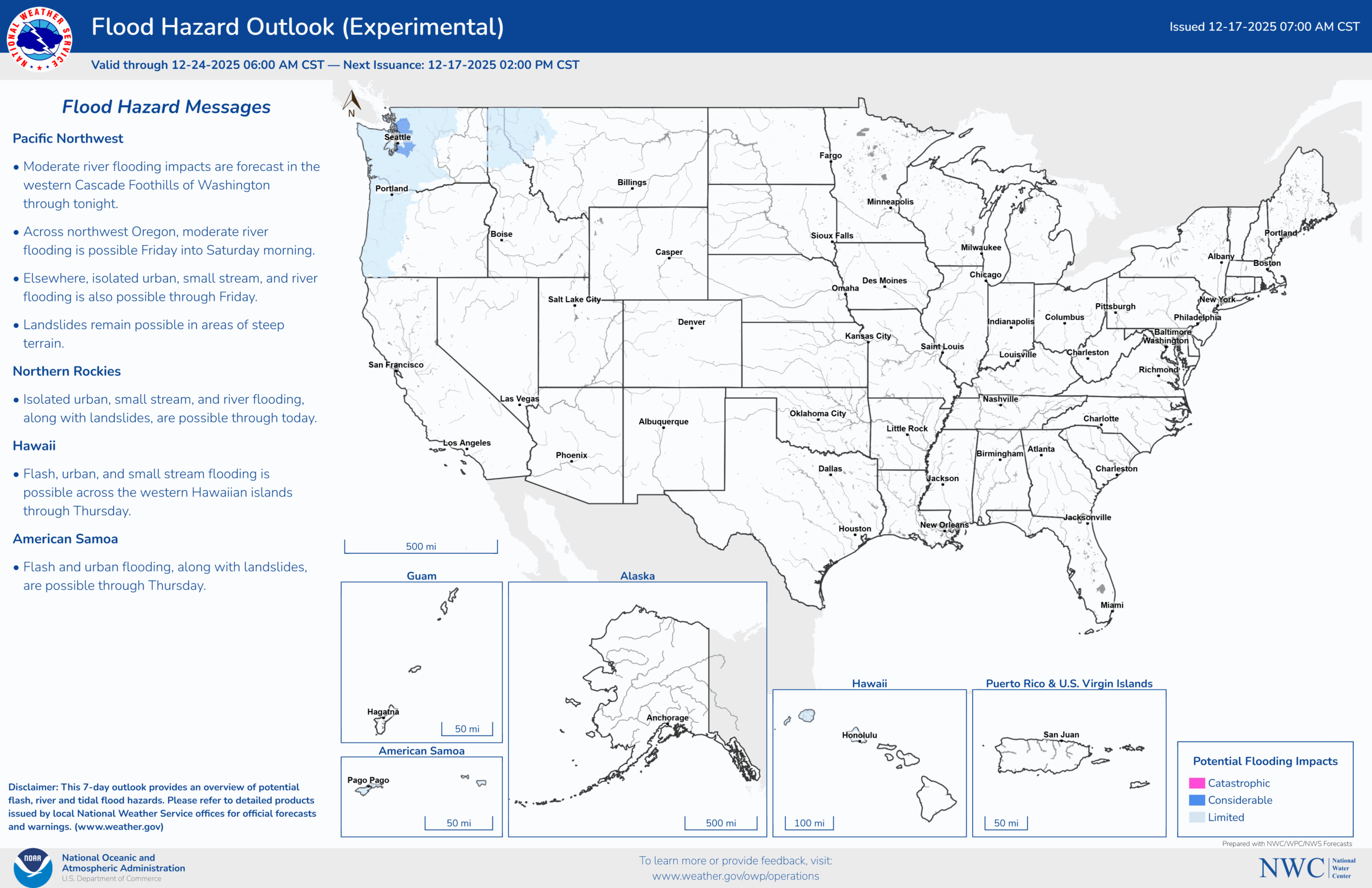
Meanwhile, back on the West Coast, thankfully snow levels are lower with this event than we saw last week. So for Washington that means less rain running off into the swollen river basins. Currently, no rivers in Washington are forecast to hit major flooding levels over the next few days, with several back into moderate flooding. Better news for sure.
In case you missed it, there was a story that dropped about the Skagit River, and this is a great example of the economic and societal value of weather forecasts. The Army Corps took over dam operations from area utilities that use dams for hydropower. By taking over operations and impounding the water rather than releasing it, about 4 to 5 feet (!) of water was kept out of the river, which prevented an already bad situation from turning into an absolute catastrophe. None of this would have been possible without good coordination, good forecasts, and quick action. This is an example of the value and benefit of weather forecasts and when government agencies and partners perform at their best.
Moving southward, the next target of the atmospheric river will be Oregon. Heavy rain and mountain snows will move in tomorrow through Saturday.
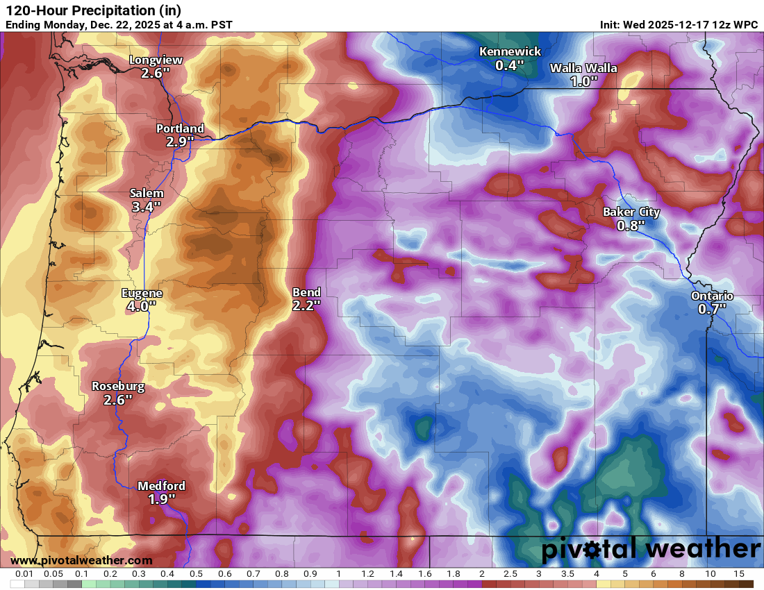
Snow levels will be low today, rise tomorrow, and lower again on Friday. While there may be snow down to pass levels, a lot of water is going to be pushed through the river systems here that are already fairly elevated. So there is some legitimately localized serious flooding risk in these areas.
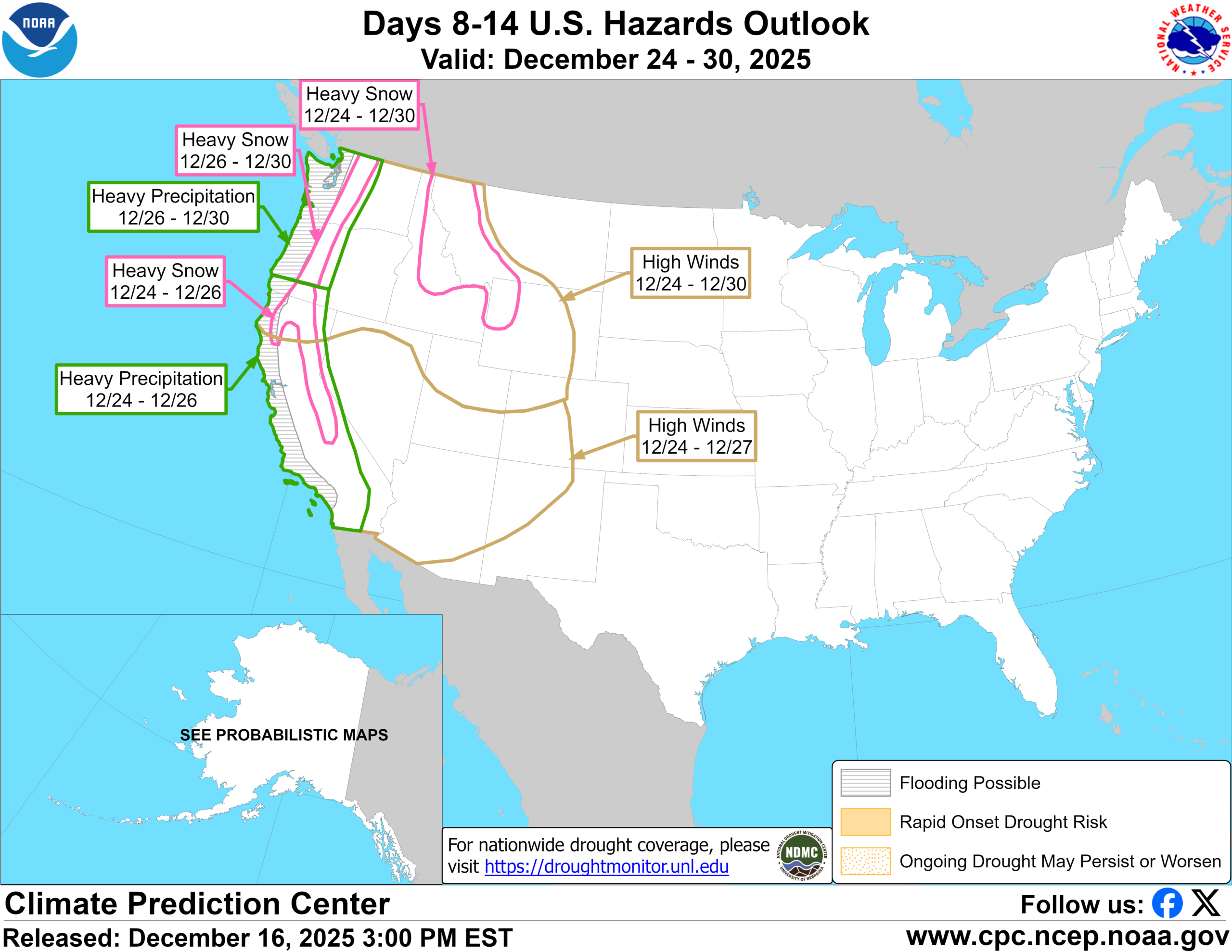
For California, the next few days will see varying levels of moisture move in, heaviest in far northern California on Friday and for parts of northern and central California on Sunday. The bigger story may be what’s coming next week, where a major storm could overtake all of California, including SoCal. This is highlighted on the 8-to-14-day hazards outlook from Tuesday, showing Christmas Eve, Christmas Day, and Friday in play for a potentially significant rainstorm and Sierra snowstorm.
So, things are busy! Folks in Cali will want to pay attention to next week’s storm, as it does have the potential to be a serious one.
Elsewhere, record warmth is a story. We’re expecting multiple days of records threatened here in Houston, with highs in the 80s next week. The interior West and even parts of the Northeast (Friday) will see record warmth tomorrow into next week. More to come.