In brief: Invest 93L is unlikely to develop much at all, but it remains a flooding risk for Louisiana heading toward Friday. We also take a closer look at flooding that has occurred in the Southside of Virginia, specifically near Petersburg.
Invest 93L
Before we begin on this disturbance, I am going to shout out a post at our Houston-focused site, Space City Weather. The amount of bad information on the northeast Gulf system that is coming from one specific source, TikTok, is almost incomprehensible. One of the main reasons our sites exist for Houston at SCW and here for others is to provide an honest forecast and information about weather from experts that are aligned with a mission of informing without being patronizing or condescending. When it’s boring, we’re boring. When things get interesting, we get interesting. We also want to make sure folks keep their eye on the ball. When it appears a storm is going to threaten southwest Florida and the media hasn’t left Tampa, we want to highlight that. When a storm is a flooding threat and has no realistic chance of becoming a hurricane, we want to focus on that. So, thanks for reading and please keep spreading the word!
Invest 93L did a good thing yesterday, coming off the Florida Peninsula farther north than expected. This will keep it closer to land and probably keep it from developing much, if at all.
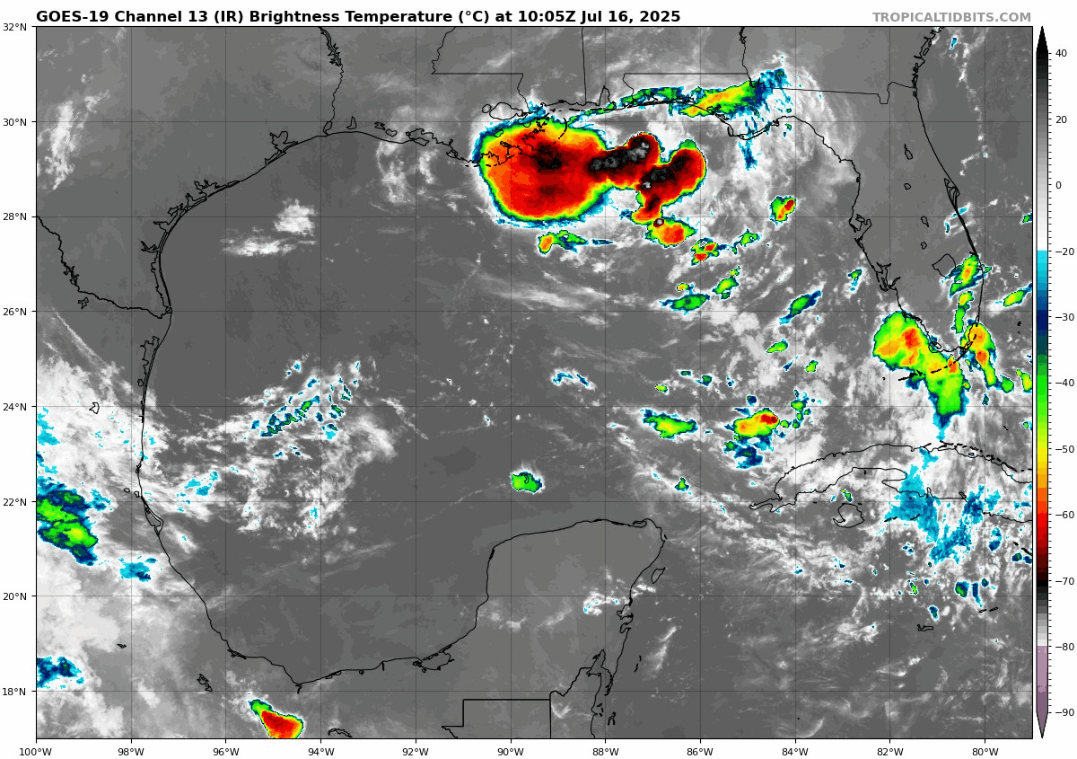
It’s not really possible to pick out a true “center” on the satellite image, but it’s somewhere near or south of Panama City. Intensity-wise, the forecast for 93L is pretty straightforward. The majority of modeling including the “corrected consensus approach” product that has had significant success in recent years keep this barely a tropical depression. Very few models bring 93L to tropical storm intensity. The NHC odds have held steady at 40%.
Let’s talk rainfall, because that will continue to be the primary story here.
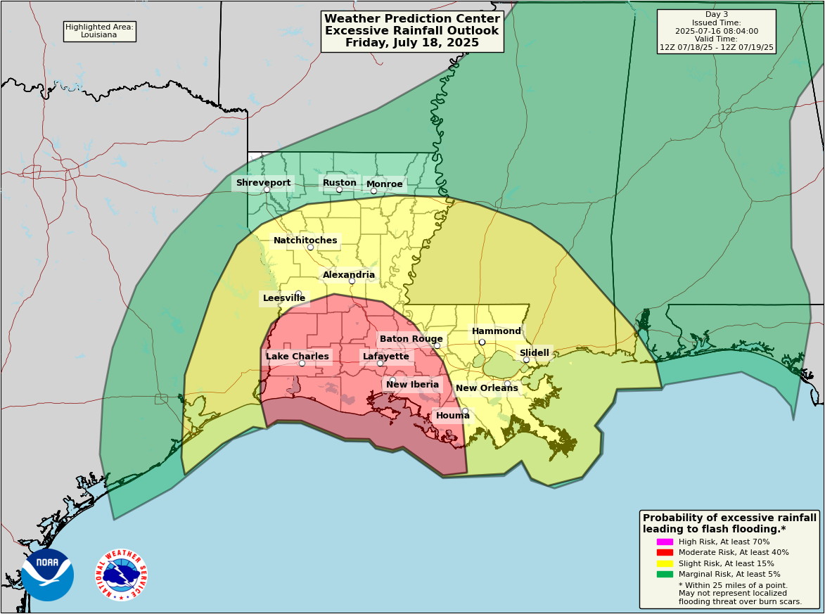
A moderate risk of excessive rainfall exists by Friday in Louisiana. The flash flood risk here seems a little less scary today, but it’s nevertheless serious.
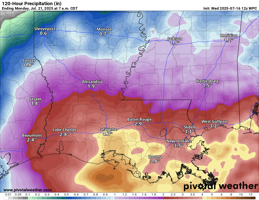
The total rainfall forecasts seem to have backed off a little, now down to 3 to 6 inches across much of southern Louisiana for this event. Still, that may cause flooding and with locally higher amounts, locally more significant flooding remains a concern, primarily between tomorrow evening and Saturday. 93L should basically dissipate and get absorbed into the broader weather pattern over the Southeast once again by next week.
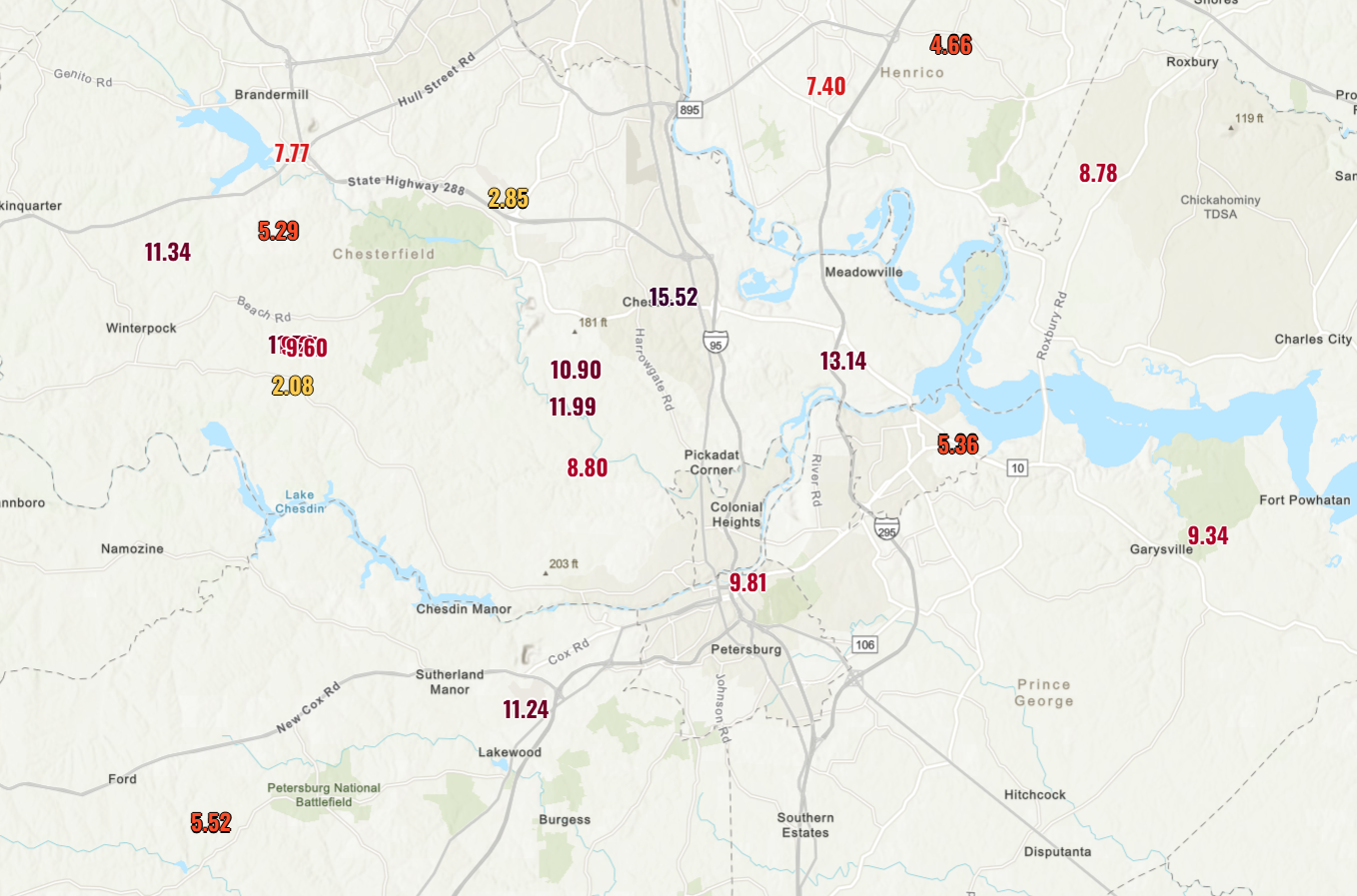
The Virginia Southside flooded multiple times
It’s been a rough week just outside of Richmond, Virginia. Petersburg has been under 13 flash flood warnings this month. It finally broke yesterday with flash flood emergencies, significant flooding, a state of emergency, and a lot of frustration about systemic neglect of mitigation measures.
Some parts of the Southside of Virginia have seen north of 10 to 12 inches of rain this month, and it’s taken a toll.
For more reading on the problems in Petersburg, I’d suggest this from the Virginia Mercury.
More on this event from WRIC in Richmond as well.
And some food for thought here: The problems in Petersburg are a microcosm of the problems facing hundreds of cities in this country. Many are plagued by poor drainage during heavy rain and backlogs of projects that would help ease the problems. The cost to get these projects across the finish line would be astronomical, and with a moving target (heavier rainfall rates as the climate warms), there’s no guarantee that even funding the wish lists of every community would lead to a successful outcome.
Thoughts on needing to travel from Houston to Baton Rouge on Friday evening? (And plans in Baton Rouge on Saturday AM.) Does that seem plausible, or is the flooding risk too severe?
Best to look at local forecast for any potential delays in travel this weekend to LA. rainfall rates can vary and change than what’s predicted.
I wouldn’t say the flooding risk is “too” severe, but it’s a bit more than usual. That said, it’s also backed off some from a couple days ago. I wouldn’t cancel plans, but I would be ready to plan around some rain or localized street flooding at least.
I read that remnants of the potential Dexter could spin around a high pressure system (like a merry-go-round) and land back in the eastern Gulf next week.
Does that sound like a reasonable possibility or is that just hype?
It’s a remote possibility, but it’s also a good 8-10 days out, so I wouldn’t be worrying about it. I even thought about mentioning the possibility this morning but decided not to because no models were particularly excited about any development from it. It’s also not necessarily uncommon for some disturbances to do things like that. Odds are still low that anything would come of it.
Thanks
Is a lesson from this that tropical clarity only exists at t-minus 48 hrs?