Headlines
- Milton is nearing hurricane strength as it begins to move eastward toward Florida
- The storm is forecast to rapidly intensify today and Monday as it encounters very warm seas
- The intensity forecast becomes more complicated as Milton nears Florida, and faces more hostile atmospheric conditions
- Residents along the western coast of Florida should make preparations today and Monday in advance of the storm’s arrival
Milton on Sunday morning
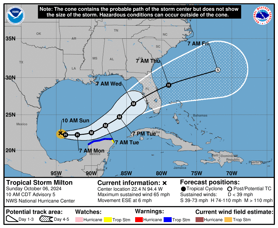
As of 11 am ET on Sunday morning, Milton has strengthened to a 65-mph tropical storm, which is just 10 mph below hurricane strength. Given that an eyewall has formed, it is likely that Milton will become a hurricane later today, and possibly strengthen into a major hurricane by Monday. The storm has started to move a little bit more, toward the east-southeast, at about 6 mph. Its motion will continue to accelerate over the next couple of days as steering currents become more pronounced.
Major sources of uncertainty
In this section I want to talk about what is known, and what is not, in regard to Milton. Let’s start with the track of the storm. Overnight, there has been a modest southern shift in several of the most important models we look at. Although there remains some uncertainty, at this time the most likely outcome for a Florida landfall on Wednesday is somewhere just north of Tampa Bay to just south of Fort Myers. I would anticipate that the track forecast will really tighten up during the next 24 hours. However, time is running out for preparations, with tropical storm-force winds possibly reaching the west coast of Florida by as early as Tuesday evening.
Next, we’ll move to intensity. This is really where there is the largest amount of uncertainty. We expect Milton to intensify rapidly over the next couple of days because it will be traversing very warm waters and face only modest levels of wind shear. The National Hurricane Center predicts that Milton will peak as a strong Category 3 hurricane on Tuesday evening, with 125 mph sustained winds, as it nears Florida. It might be even stronger.
Around that time, however, Milton will be encountering increasing levels of wind shear, which disrupts the circulation of a hurricane much like trying to skate on uneven ice. Another potentially significant factor is the intrusion of dry air from the north and west of Milton, which will be wrapped into the circulation of the hurricane. This dry air results from the front the northern Gulf of Mexico that is helping to steer Milton toward Florida. The image below shows how dry air might become entrained into Milton by Tuesday evening and Wednesday.
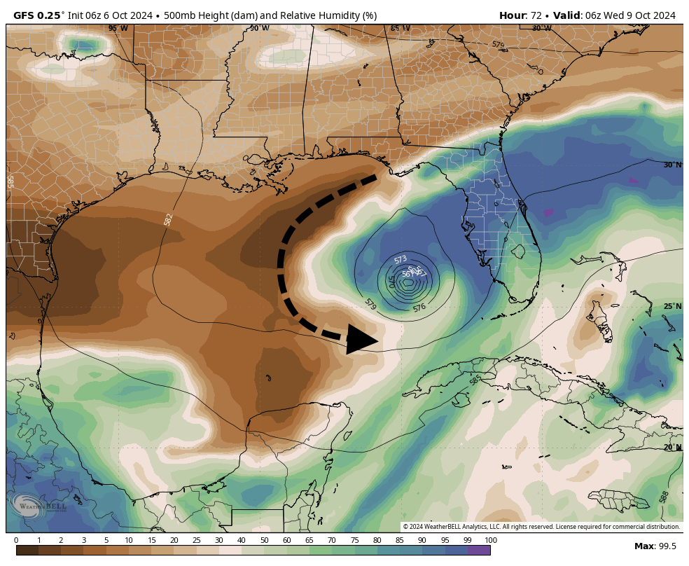
How all of this plays out is difficult to predict, even though we are only about four days from Milton making landfall. A weaker storm is unquestionably better in terms of wind damage. However, a weakening storm could also become larger (Milton is fairly small right now), and a larger storm often produces a more powerful storm surge, and has more far-reaching effects. This is why we cannot say too much about impacts from Milton for specific areas of Florida yet. Too much depends on track, size, and intensity of the hurricane, which all remain a bit fuzzy.
The bottom line remains pretty simple, however. A powerful and potentially destructive hurricane is headed toward the west coast of Florida, and will strike the state in the middle of the week. Milton will bring strong winds, heavy rains, and a significant surge to parts of the state. People who live along the west coast, especially from Fort Myers to the Tampa Bay metro area, should prepare for the worst in terms of wind, surge, and rainfall now. Much of the rest of Florida, aside from the Panhandle, should prepare for the possibility of heavy rainfall.
Tampa hurricane history
The Tampa Bay metro area, with a population of more than 3 million people, is the most developed region on the west coast of Florida. Among hurricane forecasters, the region is famous for dodging major hurricanes. A major hurricane, defined as Category 3 or larger, has not made a direct impact on Tampa Bay since 1921, more than a century ago. This was the Tampa Bay Hurricane, and was so-called because back then there was no formal naming convention for tropical storms and hurricanes.
A century ago the region had less than one-twentieth the population is does now, about 125,000 people. The Tampa Bay area has had some close calls of late, including Hurricane Charley, in 2004; Hurricane Irma, 2017; Hurricane Ian, 2022; and of course Hurricane Helene this year. Will the region’s luck hold out with Milton? It’s way too early to make any kind of prediction.
Elsewhere in the tropics
There is plenty of other activity in the Atlantic tropics. Hurricane Kirk is rampaging across the mid-Atlantic Ocean, and although it is thousands of miles distant, producing some modest swells along the US East Coast. Eventually, as an extra-tropical storm Kirk could bring some disturbed weather to northern Spain or France. Hurricane Leslie has also formed in the open Atlantic, but this storm is not going to bother anyone, anywhere. For now, the focus is going to be all about Milton.
Matt will have an update by or before 6 pm ET today discussing the latest on Milton, and our thinking on its most severe impacts.
Thanks for the Sunday morning update!
.
I’m currently watching the Fox 24 Hour Weather channel, and they mention current models [also] show a Tampa landfall about Wed AM timeframe. Obviously, they are analyzing Milton to the extreme. They mentioned the NOAA Hurricane Hunters have been dispatched this morning to fly into and investigate Milton more thoroughly.
Ugh … the NHC has now assigned Milton as a hurricane. Hopefully, it will not cause too much havoc to FL folks.
“Hopefully, it will not cause too much havoc to FL folks.”
Um, Aggie, it is a hurricane!
Has a hurricane ever killed itself by sucking in too much dry air? Are the models good at predicting how dry air affects a storm?
I forgot the name, but I believe in 2021, one heading up the Texas coast did dissipate after sucking in a bunch of dry air. It was a beautiful sight to see on the radar loop.
Don was a classic. 2011 Texas drought. It approached the coast, ingested a ton of dry air and essentially killed itself off. https://weather.com/storms/hurricane/news/tropical-storm-don-2011-drought
This is a very bad scenario – I don’t see what’s to stop it from becoming a strong 4 or more. All I can do is pray and watch and that feels horribly inadequate.
A few days ago I hoped for stapler jokes if Milton formed. I assumed it would be out in the Atlantic frolicking with Kirk and Leslie. Instead, Milton’s turned out to be no joking matter. I hope for the best for the people of Florida.
Me too 🍂🧡🍂