In brief: While it’s too early to say anything with a lot of confidence regarding the disturbance in the Atlantic, we think it will slowly crawl west this week and perhaps approach the islands by early next week. We explain what we know. Plus, the Desert Southwest may get some beneficial rain courtesy of the latest Pacific tropical depression!
Tropical Atlantic disturbance
The odds continue to increase that the wave off Africa will develop over the coming days. The National Hurricane Center is up to 70 percent odds today for the next 7 days.
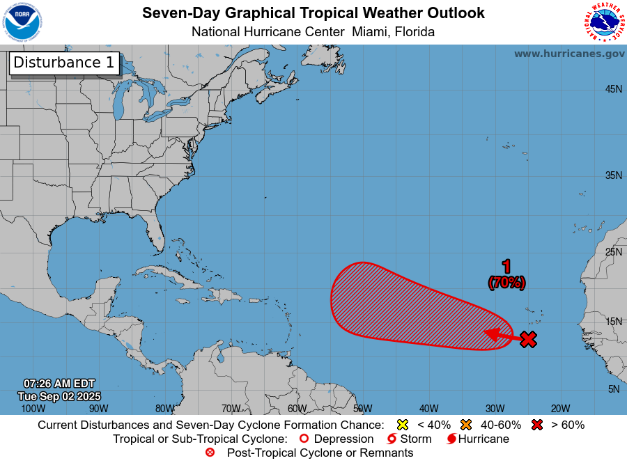
This system is still about 7 to 8 days away from making it to the islands if the models are to be believed. This one seems to be getting its act together at a much slower pace than feels usual. Whatever the case, thunderstorms are ongoing west of the tropical wave itself. Over the next 36 hours or so, expect the whole broad area to gradually consolidate into something a little more focused southwest of the Cabo Verde Islands.
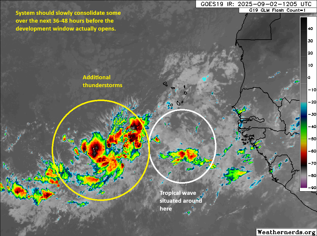
Given the current situation with thunderstorms well to the west of the wave itself, you can see that beyond “there may be a good chance of development,” much is uncertain right now. What we can say is that by Thursday morning, we should have some nascent organization ongoing, probably something like an Invest to the west-southwest of the Cabo Verde Islands.
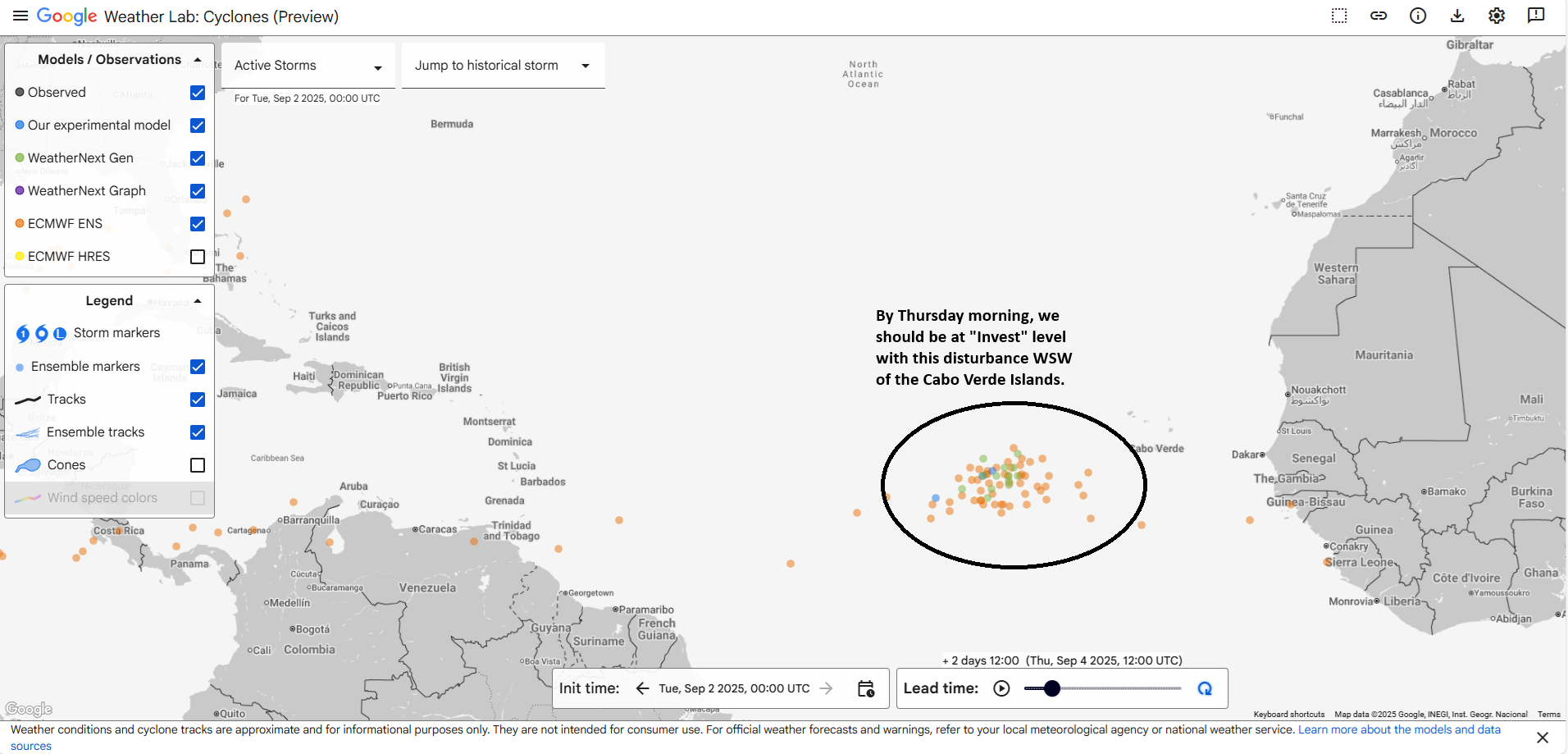
Where models can’t quite agree is at what longitude exactly this occurs. There’s a solid 6 to 7 degree spread in longitude for where this is as close as Thursday morning. This will obviously have ripple effects on whatever comes next. But rather than just throw up our hands, let’s talk about what should be happening as this comes west. Let’s assume by Saturday we have an organizing disturbance around 40 degrees longitude.
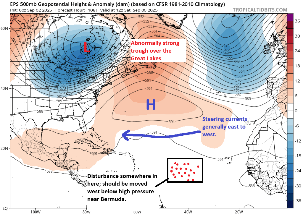
This seems to suggest that the islands should probably keep an eye on this disturbance. Any organization is probably going to be sluggish here, as there are other hurdles this still has to encounter and overcome. But I think what we can say through the weekend is that a westward moving tropical disturbance may begin to slowly develop as it approaches the Caribbean islands.
Beyond that? There I will shrug. In theory, the high near Bermuda is expected to strengthen and shift just a tiny bit east. With a lingering trough over the East Coast, this should allow it to begin gaining latitude at some point early next week. But going out from there, I don’t want to speculate on what may or may not happen. At this point in time, it’s not a realistic threat to land, but it is worth monitoring through the week for the Caribbean islands. For the U.S., you can revisit this again in a couple days. We are a long, long way out still.
After this wave, I’m sure we’ll get another, but admittedly, the next 7 to 10 days look pretty mild across the Atlantic basin other than this one disturbance.
TD 12-E in the Pacific a rainfall maker for the Southwest?
Shifting into the Pacific basin for a moment, Tropical Depression 12-E has formed, and it would appear that this will make it toward Baja by Friday, probably as a tropical storm.
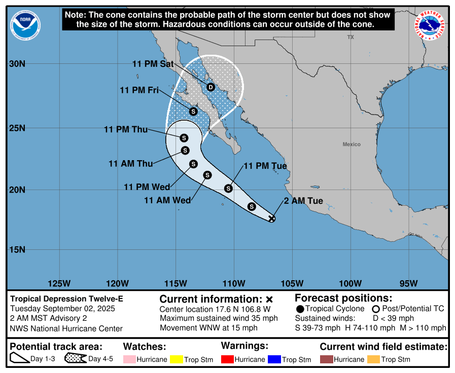
There is a chance that this system will push hurricane intensity. But 12-E (or what should be named Lorena) will probably be notable for its moisture. Additional moisture should pivot into the Southwest this week. This will allow for an uptick of (mostly) beneficial rains in the Southwest.
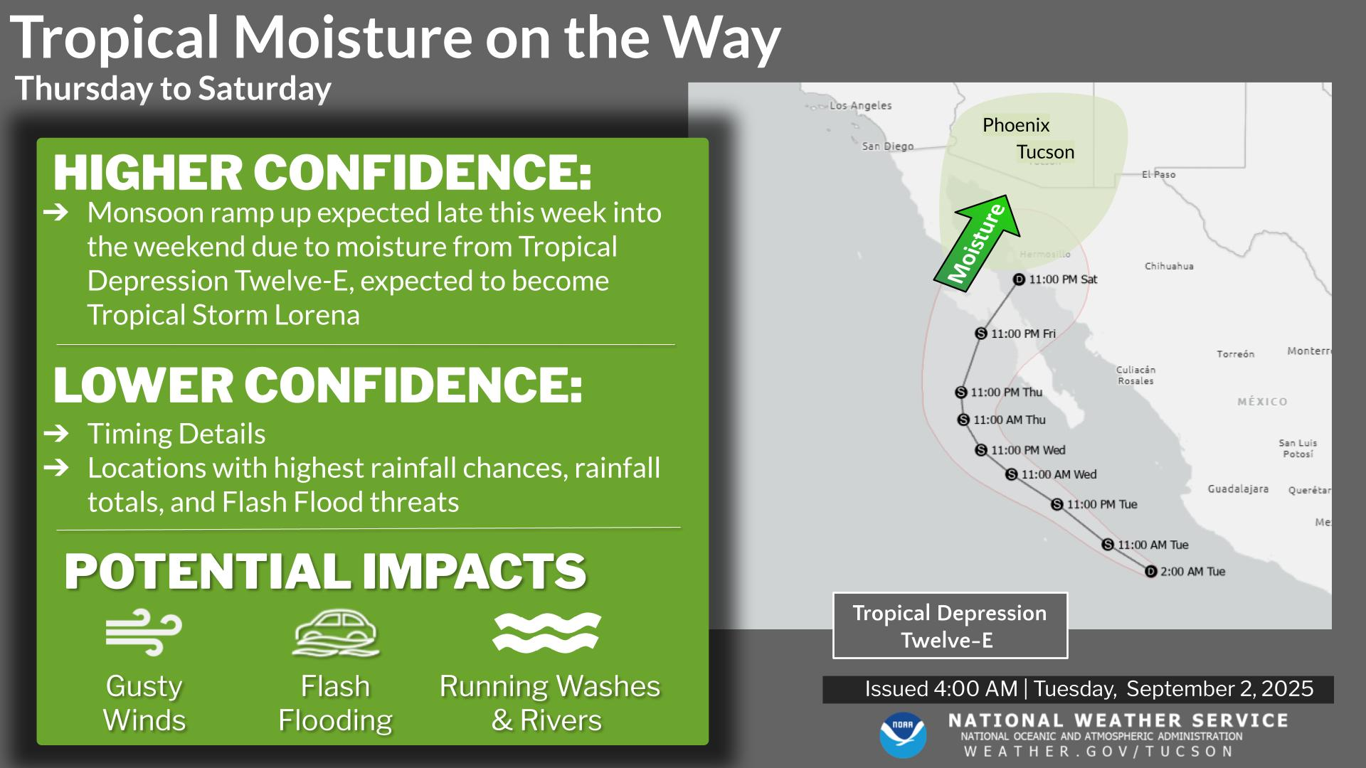
Details will still need to be sorted out, but this seems like a good setup for a tropical moisture plume to be stretched north toward Arizona and New Mexico. I would anticipate heavy rain chances, at least in scattered locations by the weekend. Indeed, the rainfall forecast for southern Arizona and even northern parts of the state is pretty lucrative over the next 7 days.
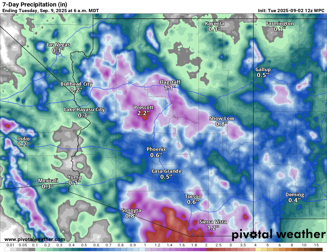
Some of the rain near the border with Mexico does fall over the next few days. Anticipate some further adjustments in the overall rain forecast for Arizona and New Mexico as we get closer to the weekend.