Headlines
- The Atlantic remains quiet for the foreseeable future.
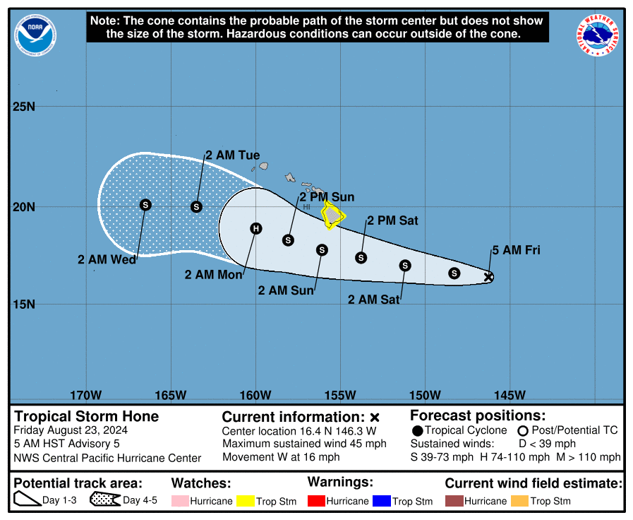
- Tropical Storm Hone will bring heavy rain and strong winds to parts of Hawaii later this week.
- A Tropical Storm Watch is in effect for the Big Island.
- Thank you to our Friday featured sponsor: EnhanceCo!
Searching for signs of life in the Atlantic
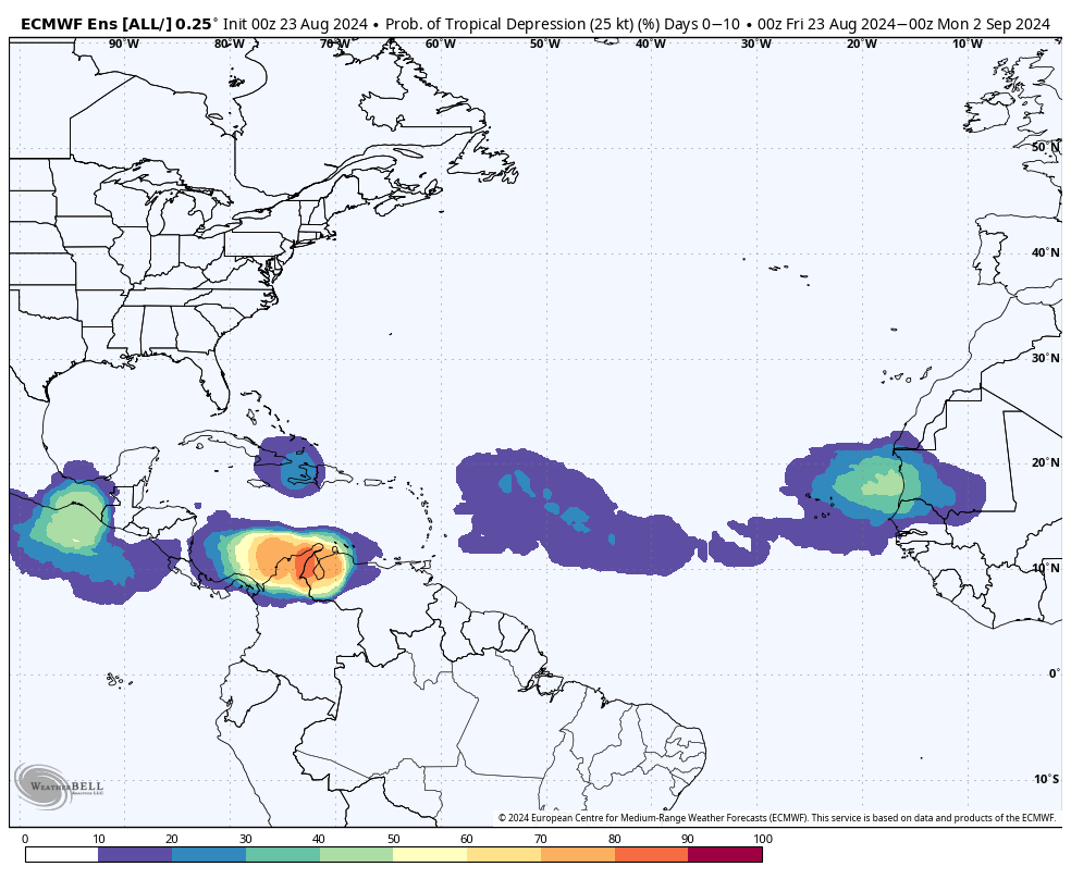
All remains quiet in the Atlantic basin with no signs of any real meaningful activity expected over the next week or two. Odds of any activity on the Euro ensemble for the next 10 days look muted as well.

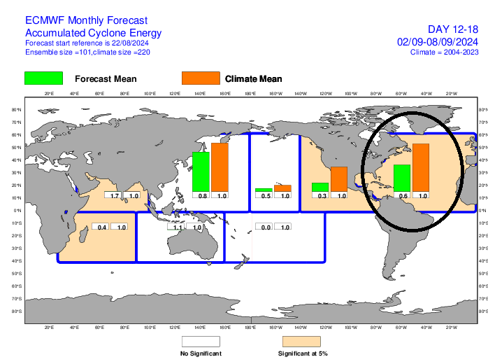
You can ignore what you see off the coast of South America. The only real candidate over the next couple weeks is probably a tropical wave that emerges off Africa around days 9 to 10. But even that seems like a low possibility. Yesterday’s extended range forecast from the European model into the first full week of September shows about half as much ACE as normal, meaning it predicts below average activity through about September 10th, the historical peak date of hurricane season.

Does this change in weeks 4 and 5? Yes, however it never gets above normal. This argues that conditions will become more favorable for tropical development as September progresses. But it may argue that conditions end up less favorable than were feared coming into the season. At the risk of jinxing things, I’ll stop there. From an accumulated cyclone energy standpoint, we are now 18 percent of the way through hurricane season. If we get to September 2nd (10 days) with nothing, we’ll be 34 percent of the way there. Historically, we ramp up quickly now. That we’re quiet through the next 7 days or more is great news.
Honing in on Hawaii
Meanwhile, the Pacific continues to pick up the slack (though you can see from the chart above that this may not continue). Hurricane Gilma continues on a road to nowhere, though its remnants could impact Hawaii next week. Behind Gilma, a new storm should form this weekend or early next week. But of more consequence is Tropical Storm Hone (Pronounce HOH-neh). A Tropical Storm Watch has been issued for the Big Island of Hawaii.

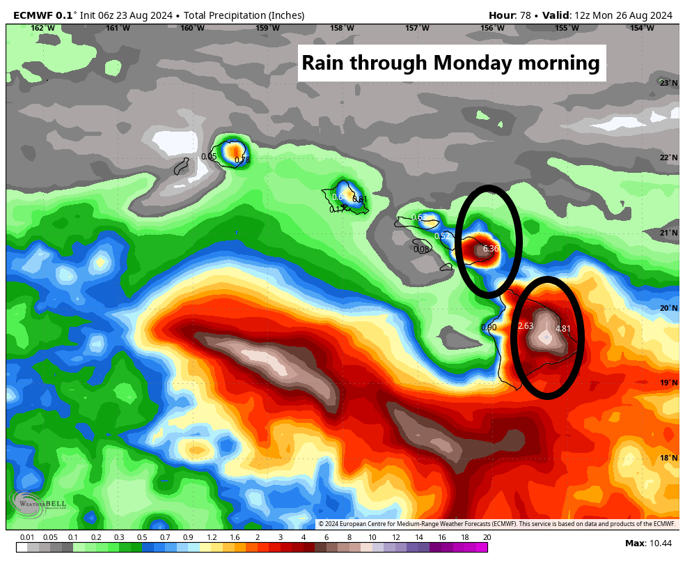
Impacts to Hawaii will be mixed. Storms aren’t as straightforward in Hawaii as they can be at times in the Mainland of the U.S. Terrain plays a huge role in who sees what. For example, with Hone passing south of Hawaii, there will be substantial upslope rain with winds out of the southeast that occurs on the southeast facing slopes of Mauna Loa and Mauna Kea. Rain will likely expand into other islands as well, but that will also be locally influenced by terrain. The strongest winds from Hone will occur on the downslope or western facing slopes and through passes. Winds could gust as high as 40 to 60 mph for folks.

Hone will continue off to the west, and then we’ll see what happens with Gilma’s remnants next week.
Friday featured sponsor: EnhanceCo
Thank you to EnhanceCo and all our sponsors for their support of The Eyewall this season!
EnhanceCo is a small family-owned company which operates both domestically and internationally to provide internal corrosion-related consulting and field services, along with customized monitoring equipment for the energy , chemical and industrial/commercial water and data center industries EnhanceCo has 40 years of field experience and recognized expertise. EnhanceCo can recognize problem areas and to assist you in developing cost-effective solutions. Their services include system surveys, troubleshooting, vendor oversight, enhancement and construction of new or legacy internal corrosion programs, training, and many other methods of assisting you in your quest for the most efficient, sustainable and proactive programs for your assets. You can visit their website at www.enhanceco.net or contact Eric Smith at 281-499-4426.
Thank you again for your support!
Very interesting to learn about EnhanceCo.
Still seeing what appears to be a lot of Saharan dust coming off of Africa, plus there’s an Atlantic Nina in place or in the process of developing.