We are days away from the beginning of the 2025 Atlantic hurricane season. If you have ever read our site before, or one of our newsletters, you know what to expect from The Eyewall: sensible, no-hype coverage about storms that you can rely on. There is an ever-increasing amount of noise online about all manner of topics, including weather. Certainly, there is some amazing data and information about weather online. But there is a lot of hyperbole. Our aim is to to provide signal amid the noise.
This will be our third year of publishing The Eyewall, and it takes a lot of time. We update at least a few days a week during the season, and when there are active storms that threaten land anywhere in the Atlantic, Caribbean, or Gulf of Mexico, we often post multiple times per day. We tell readers what we know, what we don’t, and when we should have more confidence in the forecast. We seek to provide actionable information for people and businesses to make critical decisions about their lives and property.
To cover our server and operational costs this year we are seeking some help. Our preference is to find a single sponsor for the upcoming hurricane season. The extent of your sponsorship, and nature of involvement in the site is up to you, but the bottom line is that we would credit a sponsor for being responsible for all of our coverage this year, and ensuring that it is freely available to everyone. Our readers will certainly appreciate that.
What kind of audience would a sponsor be reaching?
The Eyewall visitors in 2024: 1.1 million
Page views in 2024: 2.8 million
Majority of audience is in Texas, but have a significant following in Florida, the Carolinas, California, Atlantic Canada, and the Caribbean.
Social media reach includes 18,600 followers on Facebook, 12,400 on Instagram, 16,300 on X, 4,000 on Threads, 3,700 followers on Blue Sky
Traffic grew about 50 percent from 2023, and most of our social media accounts doubled or tripled in size.
We’re not asking for Fort Knox to sponsor the site in 2025, just a reasonable level of support. If you are interested in discussing more, please contact us here.
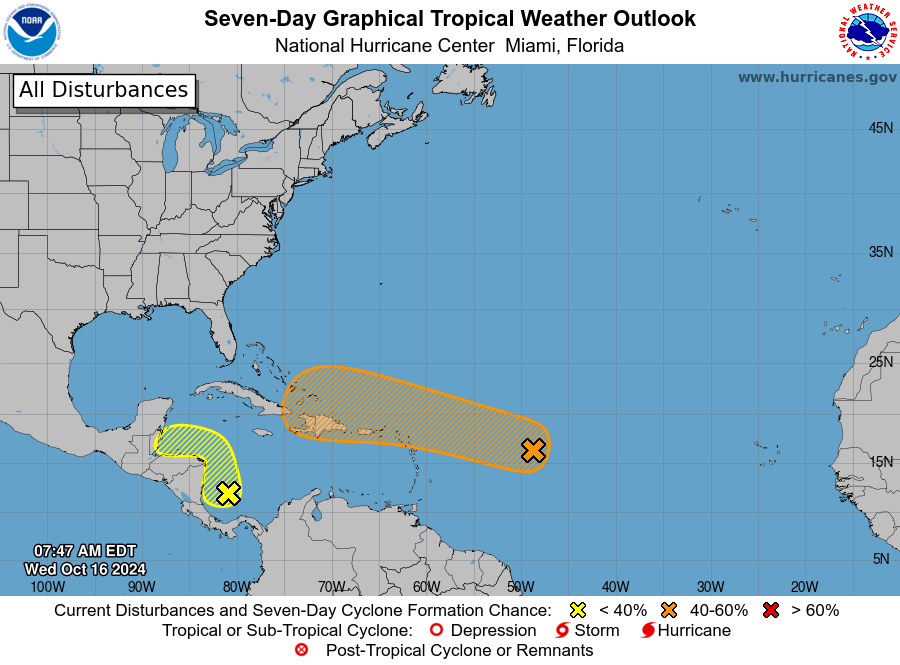
94L in the Central Atlantic Ocean continues to putter along
Significant development is less likely as the system nears the Caribbean Sea
Parts of Central America could see heavy rainfall over the next week from tropicalmoisture
Overall there appear to be no threats to the United States over the forecast period
Seven-day tropical outlook as of Wednesday morning. (National Hurricane Center)
Invest 94L
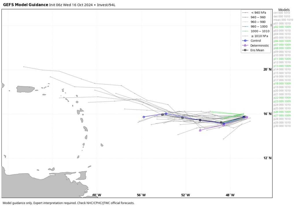
We’re continuing to track an area of low pressure that is moving across the central Atlantic Ocean. Overall, this system is expected to continue moving more or less westward, or just north of due west, this week. This would put it in the vicinity of Puerto Rico or Hispaniola by this weekend. We can be fairly confident in this general track. What I’m less certain of this morning is whether anything actually develops.
Most of the ensemble members of the GFS model indicate there’s not much to see here. (Weather Bell)
The National Hurricane Center gives Invest 94L a 40 percent chance of becoming a tropical depression or storm during the next seven days, and frankly this feels a little generous. Most of the major models that we look at no longer develop 94L into a tropical system (a few still do). In any case, this is something for the Caribbean islands and possibly the Bahamas to continue to watch, but our overall concerns for significant impacts from 94L remain fairly low. If our thinking on this changes, we’ll of course provide a timely update.
Caribbean Sea blob
The National Hurricane Center has also begun highlighting an area that Matt has been talking about for awhile in the western Caribbean Sea. This mass of showers and thunderstorms is not particularly organized, nor do I think it probably will become a depression or named storm. However, this part of the Caribbean Sea remains very warm, so there is at least the potential for something.
10-day rainfall forecast for Central America from the European model. (Weather Bell)
Regardless of development, however, this system could prove a rainmaker for southern Belize, Guatemala, and Honduras over the next week or 10 days. Depending on whether the heaviest rains remain offshore or push further inland, rainfall from this tropical blob could potentially lead to some mudslides in the region.
Elsewhere
As we get deeper into October, the tropics are starting to wind down. The Atlantic season doesn’t officially end until November 30, of course, but at this point we don’t see any near-term threats to the United States. That’s a good thing as areas hard hit by hurricanes Helene and Milton continue to recover, and start to rebuild.
Milton is nearing hurricane strength as it begins to move eastward toward Florida
The storm is forecast to rapidly intensify today and Monday as it encounters very warm seas
The intensity forecast becomes more complicated as Milton nears Florida, and faces more hostile atmospheric conditions
Residents along the western coast of Florida should make preparations today and Monday in advance of the storm’s arrival
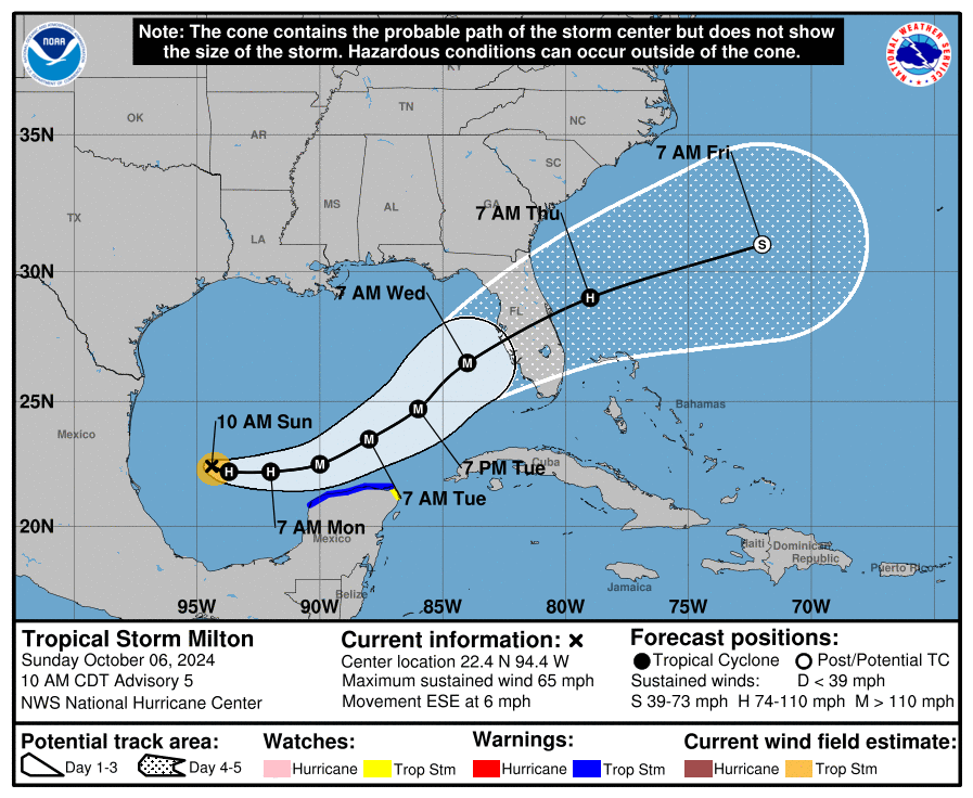
11 am ET Sunday track forecast for Tropical Storm Milton. (National Hurricane Center)
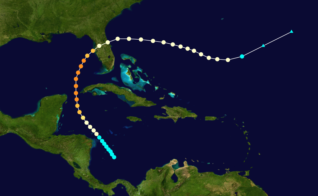
Milton on Sunday morning
As of 11 am ET on Sunday morning, Milton has strengthened to a 65-mph tropical storm, which is just 10 mph below hurricane strength. Given that an eyewall has formed, it is likely that Milton will become a hurricane later today, and possibly strengthen into a major hurricane by Monday. The storm has started to move a little bit more, toward the east-southeast, at about 6 mph. Its motion will continue to accelerate over the next couple of days as steering currents become more pronounced.
Major sources of uncertainty
In this section I want to talk about what is known, and what is not, in regard to Milton. Let’s start with the track of the storm. Overnight, there has been a modest southern shift in several of the most important models we look at. Although there remains some uncertainty, at this time the most likely outcome for a Florida landfall on Wednesday is somewhere just north of Tampa Bay to just south of Fort Myers. I would anticipate that the track forecast will really tighten up during the next 24 hours. However, time is running out for preparations, with tropical storm-force winds possibly reaching the west coast of Florida by as early as Tuesday evening.
Next, we’ll move to intensity. This is really where there is the largest amount of uncertainty. We expect Milton to intensify rapidly over the next couple of days because it will be traversing very warm waters and face only modest levels of wind shear. The National Hurricane Center predicts that Milton will peak as a strong Category 3 hurricane on Tuesday evening, with 125 mph sustained winds, as it nears Florida. It might be even stronger.
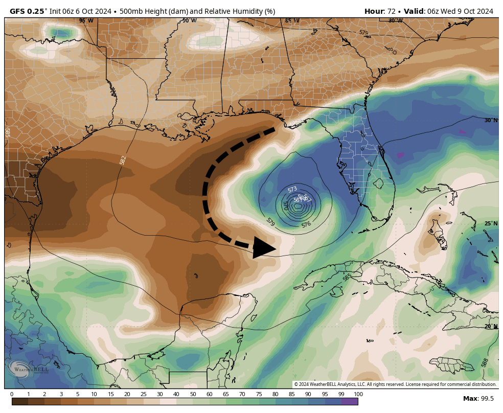
Around that time, however, Milton will be encountering increasing levels of wind shear, which disrupts the circulation of a hurricane much like trying to skate on uneven ice. Another potentially significant factor is the intrusion of dry air from the north and west of Milton, which will be wrapped into the circulation of the hurricane. This dry air results from the front the northern Gulf of Mexico that is helping to steer Milton toward Florida. The image below shows how dry air might become entrained into Milton by Tuesday evening and Wednesday.
How dry air will get pulled into the circulation of Milton by mid-week. (Weather Bell/The Eyewall)
How all of this plays out is difficult to predict, even though we are only about four days from Milton making landfall. A weaker storm is unquestionably better in terms of wind damage. However, a weakening storm could also become larger (Milton is fairly small right now), and a larger storm often produces a more powerful storm surge, and has more far-reaching effects. This is why we cannot say too much about impacts from Milton for specific areas of Florida yet. Too much depends on track, size, and intensity of the hurricane, which all remain a bit fuzzy.
The bottom line remains pretty simple, however. A powerful and potentially destructive hurricane is headed toward the west coast of Florida, and will strike the state in the middle of the week. Milton will bring strong winds, heavy rains, and a significant surge to parts of the state. People who live along the west coast, especially from Fort Myers to the Tampa Bay metro area, should prepare for the worst in terms of wind, surge, and rainfall now. Much of the rest of Florida, aside from the Panhandle, should prepare for the possibility of heavy rainfall.
Tampa hurricane history
The Tampa Bay metro area, with a population of more than 3 million people, is the most developed region on the west coast of Florida. Among hurricane forecasters, the region is famous for dodging major hurricanes. A major hurricane, defined as Category 3 or larger, has not made a direct impact on Tampa Bay since 1921, more than a century ago. This was the Tampa Bay Hurricane, and was so-called because back then there was no formal naming convention for tropical storms and hurricanes.
A century ago the region had less than one-twentieth the population is does now, about 125,000 people. The Tampa Bay area has had some close calls of late, including Hurricane Charley, in 2004; Hurricane Irma, 2017; Hurricane Ian, 2022; and of course Hurricane Helene this year. Will the region’s luck hold out with Milton? It’s way too early to make any kind of prediction.
Track of the Tampa Bay Hurricane in 1921. (Wikipedia)
Elsewhere in the tropics
There is plenty of other activity in the Atlantic tropics. Hurricane Kirk is rampaging across the mid-Atlantic Ocean, and although it is thousands of miles distant, producing some modest swells along the US East Coast. Eventually, as an extra-tropical storm Kirk could bring some disturbed weather to northern Spain or France. Hurricane Leslie has also formed in the open Atlantic, but this storm is not going to bother anyone, anywhere. For now, the focus is going to be all about Milton.
Matt will have an update by or before 6 pm ET today discussing the latest on Milton, and our thinking on its most severe impacts.
Milton has become a tropical storm in the southwestern Gulf of Mexico
The storm is likely to undergo significant intensification over favorable waters during the coming days
In all probability, a major hurricane will approach the western coast of Florida by mid-week
Some locations in western Florida have not experienced a powerful hurricane like this in several decades
Meet Milton
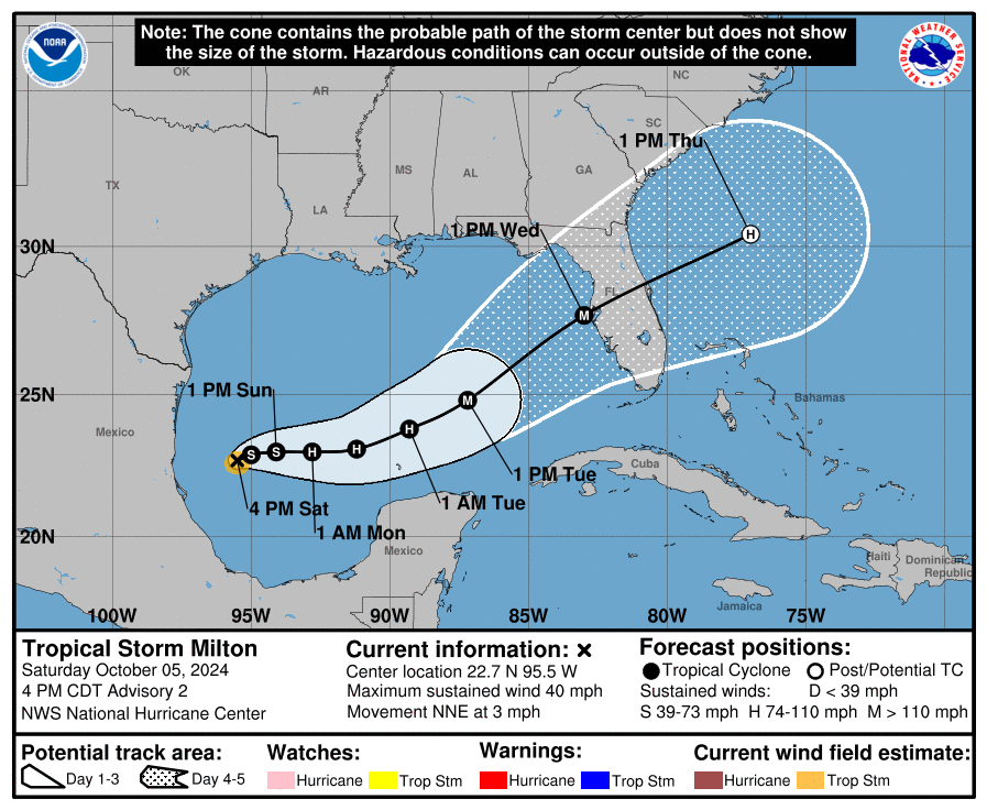
At 5 pm ET on Saturday, the National Hurricane Center upgraded a tropical depression in the extreme southwestern Gulf of Mexico into Tropical Storm Milton. The center of the storm is nearly stationary this evening, but it should start to move slowly to the east over the next day or so before accelerating. Although it is unusual for a tropical system this far west in the Gulf of Mexico to move toward Florida, that’s exactly what we expect to happen over the next four days in response to blocking in the mid- and upper-levels of the atmosphere.
5 pm ET track for Tropical Storm Milton. (National Hurricane Center)
Although we remain about four days—give or take—from a landfall along the west coast of Florida, it is important for residents of the state to take Milton very seriously. We realize that some areas of the state remain dazed by Hurricane Helene, but this is a similarly threatening storm. Although we don’t have full confidence in precisely where the storm will track, it does seem very possible that it will directly impact the greater Tampa-St. Petersburg-Clearwater metro area, which has a population in excess of 3 million people.
Please remember that the forecast can and will change in the coming days. However, we have seen a fair amount of tightening in the model solutions over the last 24 hours, and increasingly they are pointing to a powerful hurricane approaching the western Florida coast, possibly near or north of Tampa Bay, by around Wednesday of next week. This post will discuss our preliminary assessment of some of the impacts from this storm.
Track and intensity
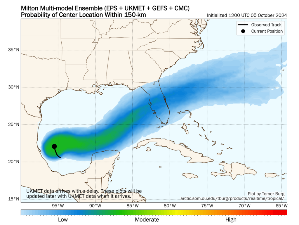
There remains a broad cone of uncertainty in regard to where Milton will go, but we can expect this to narrow somewhat during the next day or so. After Milton wobbles around the southwestern Gulf of Mexico for the next day or so, it will get picked up by a front moving down into the northern Gulf of Mexico. This will help steer the storm the east, and then the northeast over the next few days.
A view of the ensemble uncertainty in regard to Milton’s track this week. (Tomer Burg)
Most of our best modeling guidance, including hurricane specific models such as the HWRF and HAFS, brings the storm to the western coast of Florida, near the Tampa Bay region, very late on Tuesday night or Wednesday. Now that a fairly well defined center of circulation has formed, I expect modeling agreement to increase over the next day or so.
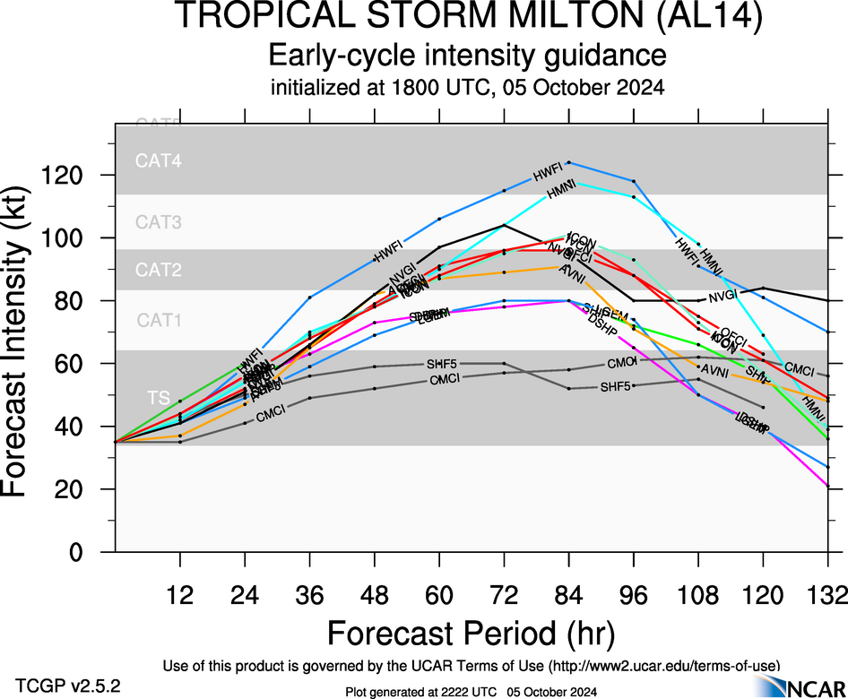
In terms of intensity, there is a broad range of outcomes. The National Hurricane Center predicts a major, Category 3 hurricane at landfall on Wednesday. However, an even more powerful storm is possible given that the Gulf of Mexico is very warm, with deep oceanic heat content, and wind shear levels unlikely to disrupt Milton’s organization. Unfortunately, this is a setup for the development of a large and powerful hurricane.
A sampling of Milton intensity forecasts from global and hurricane models. (NCAR)
Winds
Milton’s track will determine where the storms strongest winds occur; they will be along the path of the center and generally just to its right. The majority of our guidance continues to point to a hurricane somewhere between Category 2 and Category 4 intensity, which means that there is the potential for a large stretch of the Florida peninsula to experience hurricane-force winds. This level of winds will cause significant damage and likely lead to power outages.
Storm surge
With four days to develop, Milton is ultimately going to push a large and powerful storm surge toward Florida. This storm will almost certainly impact areas south of where Hurricane Helene struck in September, but at this point anywhere from the coastal bend of Florida, south to the Tampa Bay area, and further south to Fort Myers, is at risk. It is too early to talk about absolute risks, but for wherever Milton makes landfall, the storm is likely to bring a historically damaging storm surge. These impacts will be most pronounced just to the right of where the hurricane makes landfall—which again, is a location that we cannot say with any certainty yet.
Inland rainfall
Heavy rainfall is another threat from Milton. Although the storm should be moving at a fairly good clip once it reaches Florida by the middle of this week, Milton could nonetheless drench a swath of the state, from west to east as it crosses the state. Whether this occurs in the central part of the state, such as the vicinity of Orlando and the Space Coast, or further north in the coastal bend and Jacksonville, is just not clear yet. However, the risk is there for 10 or more inches of rainfall in a short period of time, which will lead to flash flooding.
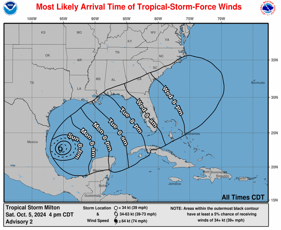
Most likely arrival time of tropical storm force winds. (National Hurricane Center)
Conclusions
If you’ve read this post up until now, you’ll realize that we cannot say much more at this time beyond stating that a serious hurricane threat is coming to the state of Florida this week. Sunday and Monday will be a time for preparations, as impacts such as wind and heavy rain are likely to reach the state as early as Tuesday evening.
We will have continuing coverage on The Eyewall as this very serious threat develops.