A tropical wave in the Atlantic is moving due west, but its future is unclear

Headlines

  • All eyes are on a system in the tropical Atlantic
  • It is not clear whether this system will ultimately develop as it tracks toward the Caribbean Sea
  • Elsewhere the tropics are quiet, but there are hints this could change in a week or so

Focusing today on the Central Atlantic

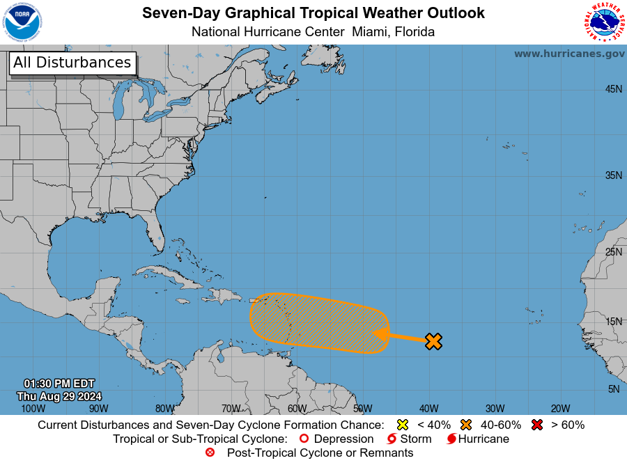
The most likely candidate for the Atlantic basin’s next named storm—it would be Francine—remains a tropical wave over the Central Atlantic Ocean. As of Thursday afternoon, the National Hurricane Center continues to pin a 40 percent chance on this system becoming a tropical depression or storm in the next seven days.

National Hurricane Center tropical outlook for Thursday afternoon.

Honestly, we have a lot more questions about this system than answers. And if you’re wondering what impacts this will have after it gets into the Caribbean Sea, or downrange to the United States or Mexico, the short answer is stay tuned. It could never get off the ground, or it could eventually become a tropical system that moves into the Gulf of Mexico. We don’t know, and that’s the bottom line.

So the rest of this update will focus on what we do know. As it presently exists the system is a disorganized mass of showers and thunderstorms. However, over the next several days, it should find supportive atmospheric conditions as it approaches the Caribbean Sea. Once it passes the Leeward Islands, some development is possible. It probably would be slow.

Will it develop?

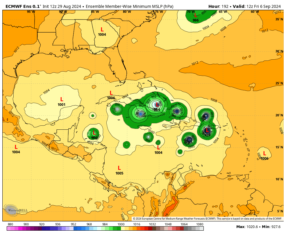
So will it? I like the National Hurricane Center odds of about 40 percent. Not all of our operational models bring the system to depression or tropical storm strength over the next week, and although there is some support in the ensembles, it is not super robust. For example, here is what the 12z ensemble forecast of the European model looks like from today. Some of the members show development, but this is far from a consensus.

Euro ensemble forecast for just after midnight on Friday, September 6. (Weather Bell)

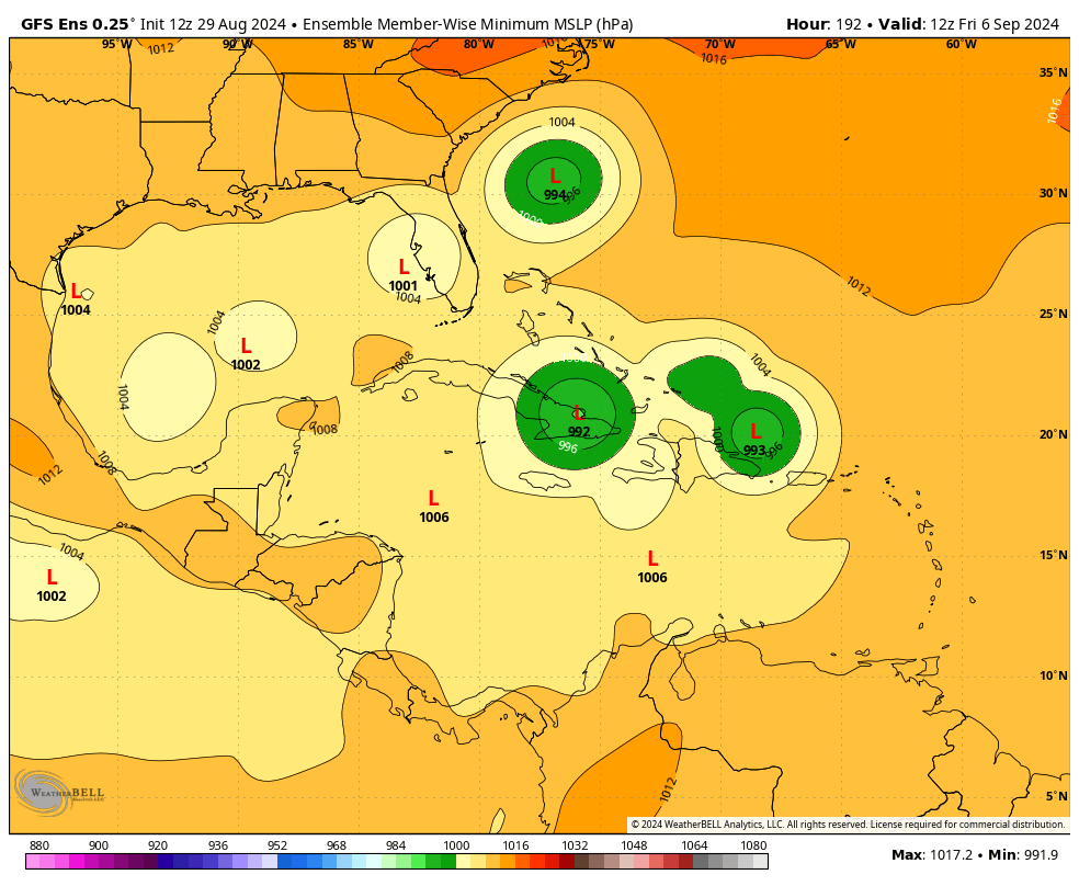
If we look at the GFS ensemble forecast for the same time period, there is even less support for anything beyond a very weak tropical storm.

GFS ensemble forecast for just after midnight on Friday, September 6. (Weather Bell)

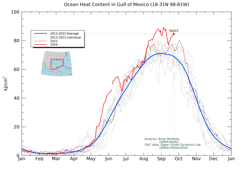
So why are we paying so much attention to this system? It is because we’re now at the end of August, with September on the horizon; and the Atlantic seas are blazing hot. If a storm like this gets going, it will be difficult to stop, in terms of intensification. So yes, any tropical system moving toward the Caribbean Sea is going to catch our eye at this time of year. Especially when there’s not much else happening in the tropics unless we really squint.

In this case, we just need to watch and see what happens over the next couple of days. This system could develop and become Francine, or it could fizzle out. If it does form, it might eventually move toward the Gulf of Mexico, or turn northward before hand. We just don’t know, and won’t know, for awhile now.
There continues to be hints in the models that, regardless of what happens with this system, the tropics are going to start lighting up quite a bit in about a week or so. For now, we’re going to have to sit back and see what happens.

Debby strengthening as it bears down on Florida, bringing serious surge and winds, with significant flooding into next week

Headlines

  • Tropical Storm Debby is intensifying, and will soon reach hurricane strength
  • A landfall will occur on Monday, in the coastal bend area of Florida, with a strong surge only slightly less than that of Hurricane Idalia
  • Significant rains and winds will spread over much of the northern half of Florida on Monday
  • From Tuesday onward the focus turns to the Atlantic coastal regions, from Jacksonville north through South Carolina, with the threat of very heavy rainfall

Debby status at 8 pm ET Sunday

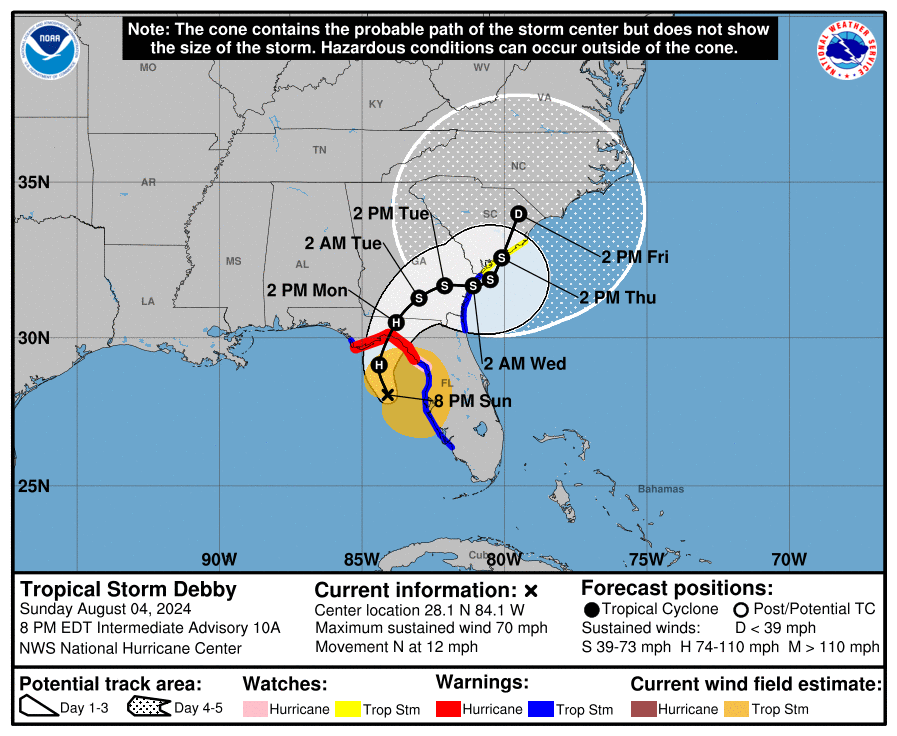
As of this evening, Tropical Storm Debby is nearing hurricane strength with 70-mph sustained winds. It likely will reach hurricane strength tonight, and then continue to intensify before making a landfall somewhere in the parklands along the coastal bend of Florida on Monday. A hurricane warning is now in effect for the Florida coast from the Suwannee River to Indian Pass.

After Monday night, the track of Debby becomes highly uncertain. (National Hurricane Center)

Immediate threats to Florida

Debby has lashed the west coast of Florida for much of the weekend, bringing heavy rains, tropical storm-force winds, and bands of rainfall to the Sunshine State. The storm has more or less been moving north for much of Sunday, and that will not change a whole lot overnight before the storm makes a slight northeastern turn towards the coastal bend of Florida on Monday. The storm will bring three major hurricane threats to the Florida coast tonight and on Monday.

Storm surge

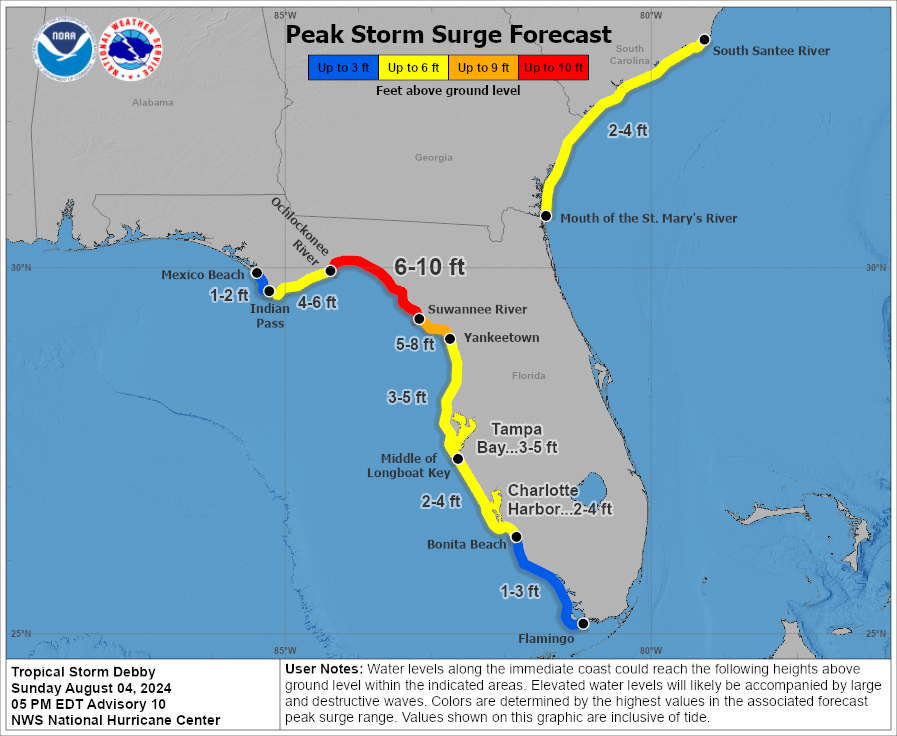
As Debby has strengthened and grown larger today, it is likely to produce a more potent storm surge. Nearby residents will well remember the surge of Hurricane Idalia, a more powerful hurricane that made landfall a little more than 11 months ago in a similar location. Although Debby’s storm surge will not be as potent as that of Idalia, it will nonetheless be significant. Forecasters from the National Hurricane Center now anticipate a surge as great as 6 to 10 feet from the Suwannee River northward to the Ochlockonee River at high tide.

Peak storm surge forecast. (National Hurricane Center)

Winds

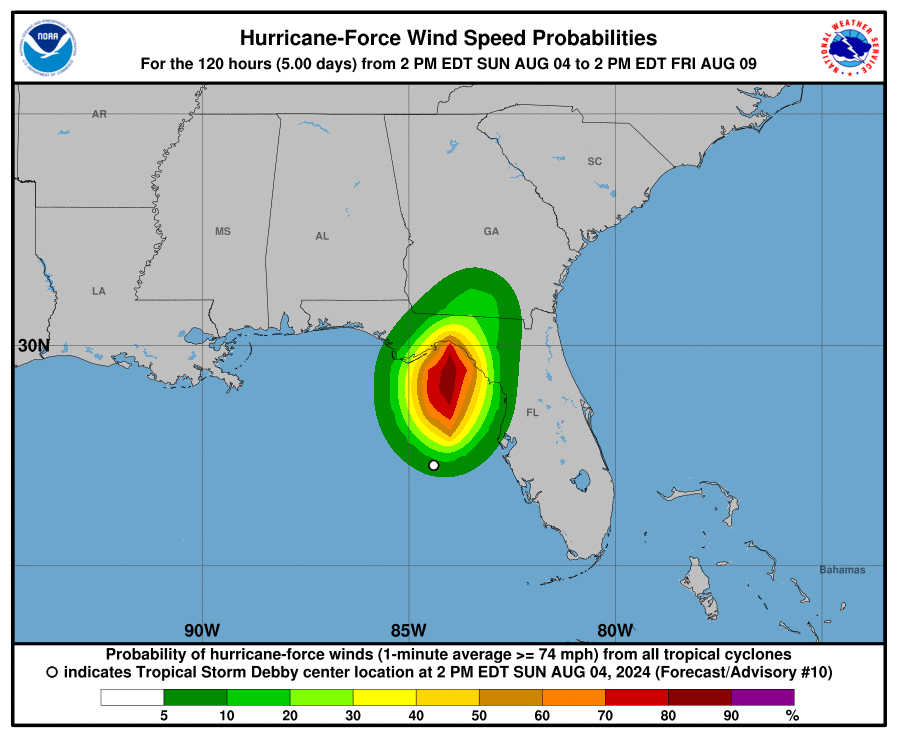
Hurricane force winds could arrive at these coastal areas of Florida as early as Monday morning, with tropical-storm force winds likely for much of the northern half of Florida, and into southern Georgia. The area of hurricane-force winds (shown in the map below) will be smaller. Such winds can knock down power poles and do considerable tree damage. The landfall of Debby is also likely to spawn several tornadoes across the northern half of Florida.

Map showing areas most likely to be impacted by hurricane-force winds. (National Hurricane Center)

Inland rainfall

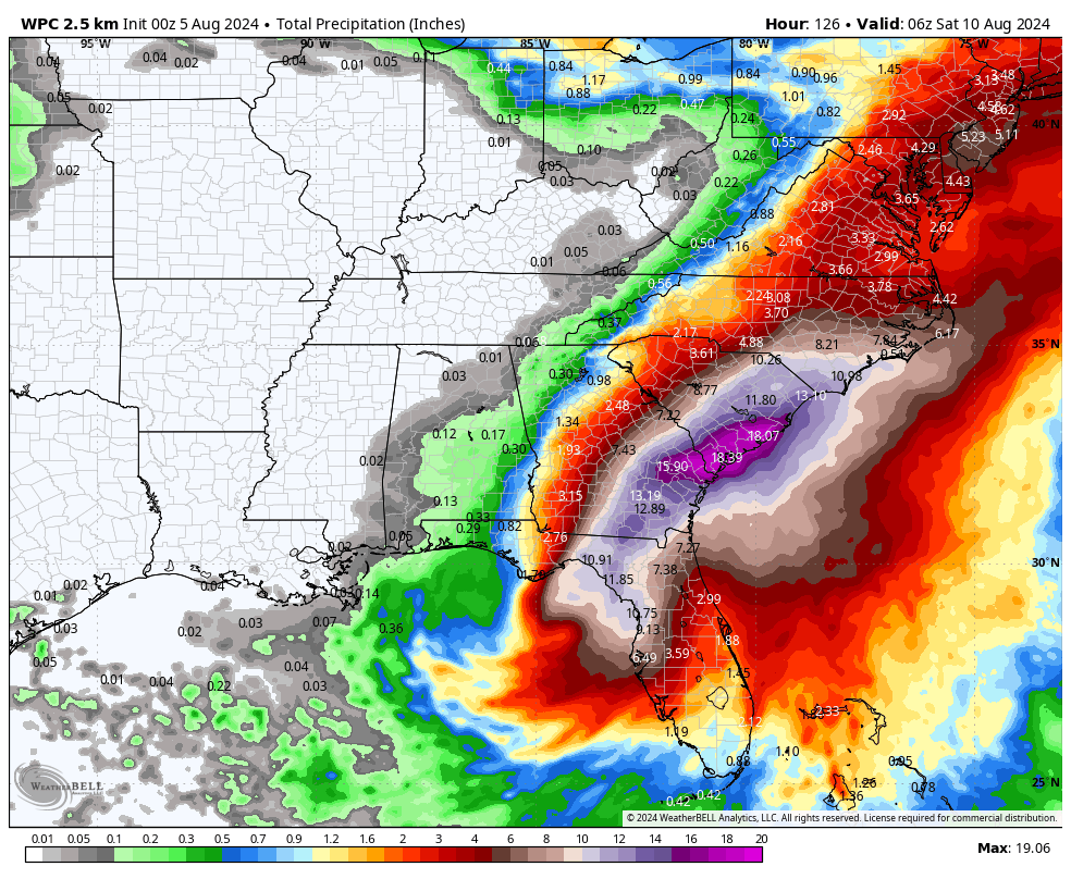
The third major threat from this storm will be heavy rainfall, which leads to flooding away from the coast. As much as 8 to 16 inches of rainfall will be possible along and north of a line from Tampa Bay to Orlando, with the heaviest showers likely along and to the immediate right of Debby’s track. Where training bands set up, there will be considerable street flooding and the potential for flooding of homes and businesses. This will compound the effects of damaging winds.

Longer-term impacts

By late Monday or Tuesday the center of Debby should be crossing through Southern Georgia, and then emerge into the Atlantic Ocean somewhere between Jacksonville, Florida, and Hilton Head Island, South Carolina. And then, it’s going to sit and spin awhile. Our latest modeling (18Z) is not helping much, but there’s a general trend toward Debby being forced back toward the Atlantic coast of Georgia by Wednesday or Thursday in response to a high pressure system building over the central Atlantic Ocean.

Extreme rainfall accumulations are likely this week from Tropical Storm Debby. (Weather Bell)

All of this is likely to bring some pretty serious winds and surge to coastal areas from northern Florida to Georgia and through at least South Carolina. We can be highly confident in a significant rain event for these areas, but winds and seas will depend on the ultimate track of Debby. The bottom line is that these areas should be prepared for impactful weather from Tuesday through Thursday. Hopefully, in the next day or so, we can better define the timing and the extent of these threats.

A tropical storm, or possibly a hurricane, is likely to reach Florida late late Sunday or early Monday

Headlines

  • Tropical Depression Four is crossing Cuba and will enter the Gulf of Mexico later today
  • This storm will menace the west coast of Florida with winds and surge this weekend, with heavy rainfall also likely
  • The system may reach tropical storm status, or possibly even become a hurricane before landfall along Florida’s coastal bend
  • Downstream there is a significant threat of flooding in Georgia and the Carolinas

Tropical Depression status

The tropical disturbance we’ve been tracking for much of this week has become Tropical Depression Four, with sustained winds of 30 mph. The center of the storm is in the vicinity of western Cuba as of Saturday morning, and moving to the west-northwest. As it moves into the southeastern Gulf of Mexico later today the depression should find favorable conditions for some strengthening, and forecasters believe it will become a strong tropical storm or possibly a hurricane before landfall somewhere along the coastal Bend of Florida on Sunday night or Monday.

Official track from the National Hurricane Center at 8 am ET on Saturday.

This will basically be a tale of two storms. There is the first part, the storm’s path across the Gulf of Mexico and impacts on Florida. Then, it now appears more likely than not the storm will cross the Florida peninsula and move into the Atlantic Ocean off the coast of Georgia and the Carolinas. There, the storm’s track is far less uncertain. So this post will discuss the first half impacts to Florida, and the second-half impacts to the southeastern United States.

Confidence in the track prior to landfall in Florida is high. There is considerable uncertainty thereafter. (Weather Bell)

Florida impacts

Tropical Storm Warnings are in effect for most of the western coast of Florida, with Hurricane Watch in effect for the coastal bend portion of the state. Because the models are increasingly confident in a track between now and a landfall in about 48 hours, or less, the larger question is how strong the storm will get. The majority of model guidance this morning still indicates the storm will remain at tropical storm strength prior to landfall. However, the eastern Gulf of Mexico is rather warm, and could support further strengthening. The bottom line is that some areas of Florida north of Tampa Bay and to the east of Indian Pass, may see hurricane-force wind gusts. Surge impacts look fairly modest, 3 to 5 feet in areas near and to the right of the storm’s landfall.

Where tropical-storm force winds are most likely from this system. (National Hurricane Center)

Probably the largest impact to Florida will be rainfall totals, as the entire west coast of the state, from Key West north to Tallahassee, could see between 4 to 10 inches of rainfall over the next two days as the storm’s center moves north in the Gulf of Mexico, remaining just offshore the state. This puts Florida to the right of the center, where heavy rains are most likely.

NOAA rain accumulation forecast for now through Monday. (Weather Bell)

For much of Florida, as the storm moves away by Monday afternoon or evening, these impacts will lessen. The bottom line is that state residents need to be vigilant for heavy rainfall beginning as soon as this morning.

Southeastern US impacts

The storm should cross over northern Florida and perhaps southern Georgia on Monday before reemerging into the Atlantic Ocean late on Monday night or some time on Tuesday. At this point our uncertainty ratchets up. This is because, increasingly, it looks like the storm may stall offshore, near the Georgia or South Carolina coast. If it does, it could re-strengthen some, battering the coast with winds and waves. Given the model uncertainty, I don’t feel confident in making a forecast for wind strength yet, but the southeastern United States, including Georgia and the Carolinas, should be prepared for impacts from this storm from Monday night through at least Wednesday. Again, the timing and intensity of the storm will depend on the extent to which its center moves offshore, and how long it lingers in the absence of steering currents.

The potential for flooding is high in the Southeast next week. (Weather Bell)

The other significant impact of a stalling storm, of course, would be the potential for heavy rainfall over a longer period of time. Forecast models are indicating some pretty high rainfall totals for coastal areas of Georgia and South Carolina, especially. There is the threat that these areas may see 10 inches or more, with significant flooding possible should the storm linger offshore, or just inland for a couple of days.

We will have an additional post on this tropical cyclone later today.

Forecast for tropical disturbance becomes clearer: A threat to Florida, and then the US East Coast

Headlines

  • Invest 97L has reached Cuba, and will near the Florida Keys by Saturday
  • Our confidence in its track is increasing, raising the risks to Florida, and lowering them for the northern Gulf of Mexico coast
  • All tropical threats are in play, but we’re most concerned about heavy rainfall at this time
  • Risks are also rising for the southeastern United States, particularly coastal regions of Georgia and the Carolinas

Status of Invest 97L

The tropical wave we’ve been tracking continues to get better organized, and it now has the designation Invest 97L. The approximate center of the system is now near or over the eastern end of Cuba, and it should move along the island today bringing showers and thunderstorms to Cuba and other Caribbean islands. Interaction with land may limit any attempts to organize today, but by Saturday it should emerge near the Florida Keys and move into the southeastern Gulf of Mexico. At this point the National Hurricane Center gives the system a 90 percent chance of eventually becoming a tropical depression or storm. In this case it would be named Debby.

Tropical outlook from the National Hurricane Center as of Friday morning.

Forecast clarifies some

If you read our update on Thursday, you’ll recall we were in “watch-and-see” mode with this tropical system. Well, we’ve watched. And now, we’ve seen. All of our major model guidance now predicts that 97L will move into the southeastern Gulf of Mexico, and likely remain near—perhaps just offshore—the coast of Florida on Saturday and Sunday. During this time it could well strengthen into Tropical Storm Debby, but this is not sure thing as I don’t know how disorganized 97L will be when it moves off of Cuba.

At some point this weekend, perhaps on Sunday, or Sunday night, 97L is likely to turn toward the northwest. This could bring the system into Florida anywhere from south of Tampa Bay to the coastal bend of Florida. A stronger storm would likely turn more quickly. In any case, residents of the Florida Keys and the West Coast of Florida should be preparing for tropical weather as early as Saturday.

There are questions about where the tropical system will move inland into Florida, and how long it may spend over the Atlantic Ocean. (NCAR)

After 97L crosses the Florida peninsula it may reemerge into the Atlantic Ocean somewhere near Jacksonville, Florida. At that point its center should remain just inland, or perhaps move offshore before moving into South Carolina or North Carolina as a stronger storm. East Coast regions from Jacksonville north to coastal Carolina and possibly even Virginia should be prepared for tropical impacts from Monday through Wednesday of next week.

We mentioned that residents of the northern Gulf of Mexico coast should remain vigilant in yesterday’s post, but at this point all of our guidance suggests the storm’s impacts will occur from the Florida Panhandle and to the east.

97L impacts

So far we’ve mentioned that coastal residents in Florida and up the East Coast should prepare for tropical weather, because all of the impacts associated with a tropical system are in place: strong winds, storm surge, and inland rainfall. The extent of these impacts will depend on how much 97L strengthens before moving into the west coast of Florida, and then whether it has time to restrengthen over the Atlantic Ocean if it spends time offshore of Georgia and the Carolinas. That is impossible to forecast at this time, and probably won’t be until 97L develops a better defined center of circulation.

NOAA rain accumulation forecast for now through next Thursday. (Weather Bell)

The one bit of good news is that it now appears that this tropical system will probably miss an area of low steering currents over the northern Gulf of Mexico. This means that its track should be more conventional, first turning north, and then to the northeast as it moves poleward. This should help to limit rainfall totals, but some of our models are still showing very high amounts in coastal areas of Western Florida and coastal Carolina. Again, these totals will depend on the location and forward speed of the storm this weekend and during the first half of next week. Regardless, flooding is a concern.

Elsewhere in the tropics

Beyond 97L, as we get deeper into August, there is likely to be some activity over the next week or 10 days. At this point the area of greatest interest may be the southern Caribbean Sea, where something may spin out of the gyre in that region next week. We shall watch and see what happens.