In brief: Flooding swamped parts of northern California yesterday, as attention focuses to a potential serious and significant flooding risk in the LA Basin in SoCal on Wednesday. Meanwhile, snow levels will drop enough to get some good snows in the Sierra. Elsewhere, it will be the warmest Christmas on record in many parts of the country with a pretty crazy warm weather pattern anchored over the Central U.S.
NorCal flooding
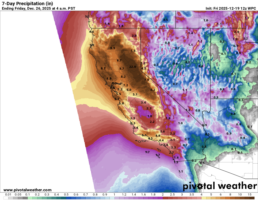
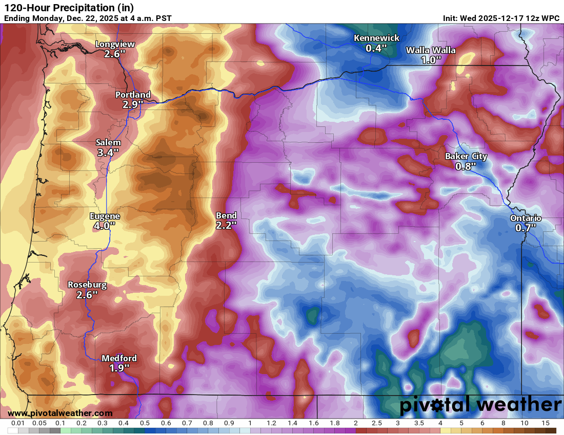
Atmospheric river moisture pounded parts of California over the weekend, delivering widespread rains generally north of I-80. 13 inches of rain was reported in the Sierra near Serene Lake, just west of Sugar Bowl Ski Resort (which is temporarily closed but expecting snow tomorrow night). Over 11 inches fell just south of Storrie, CA as well, north of I-80 in Plumas County. Same story for Strawberry Valley in northeast Yuba County.
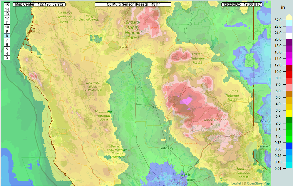
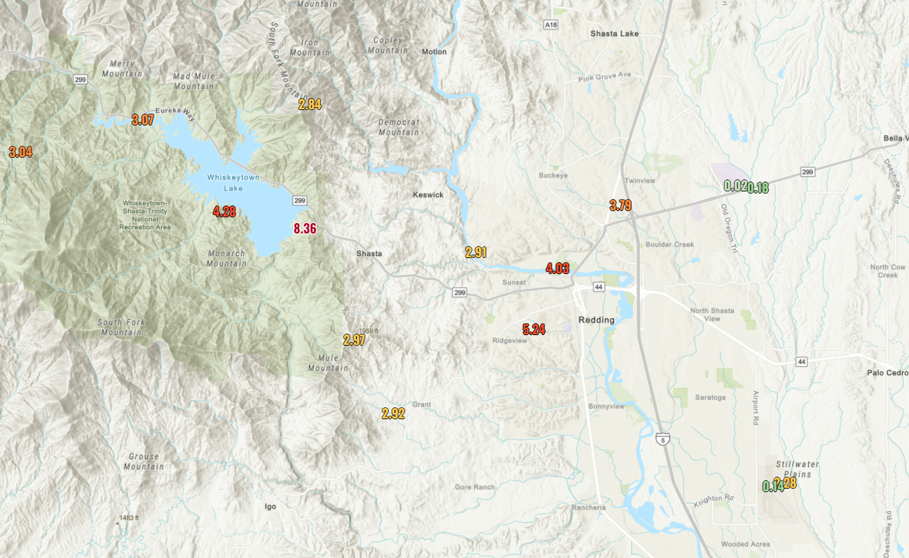
In the Redding area, flooding was particularly bad. A fairly common feature (the Shasta County convergence zone) set up near or just north of the city last night. If you track the radar loop below, you’ll be able to see a pencil thin area of heavy rain that setup for several hours near “KRDD,” or Redding.

This led to significant flooding in the Redding area, where only 1.44 inches officially fell yesterday. But the airport is just south of the city, so it missed the heaviest precip, which was probably closer to 3 to 6 inches with isolated higher amounts.
Unfortunately, one fatality was reported from the flooding.
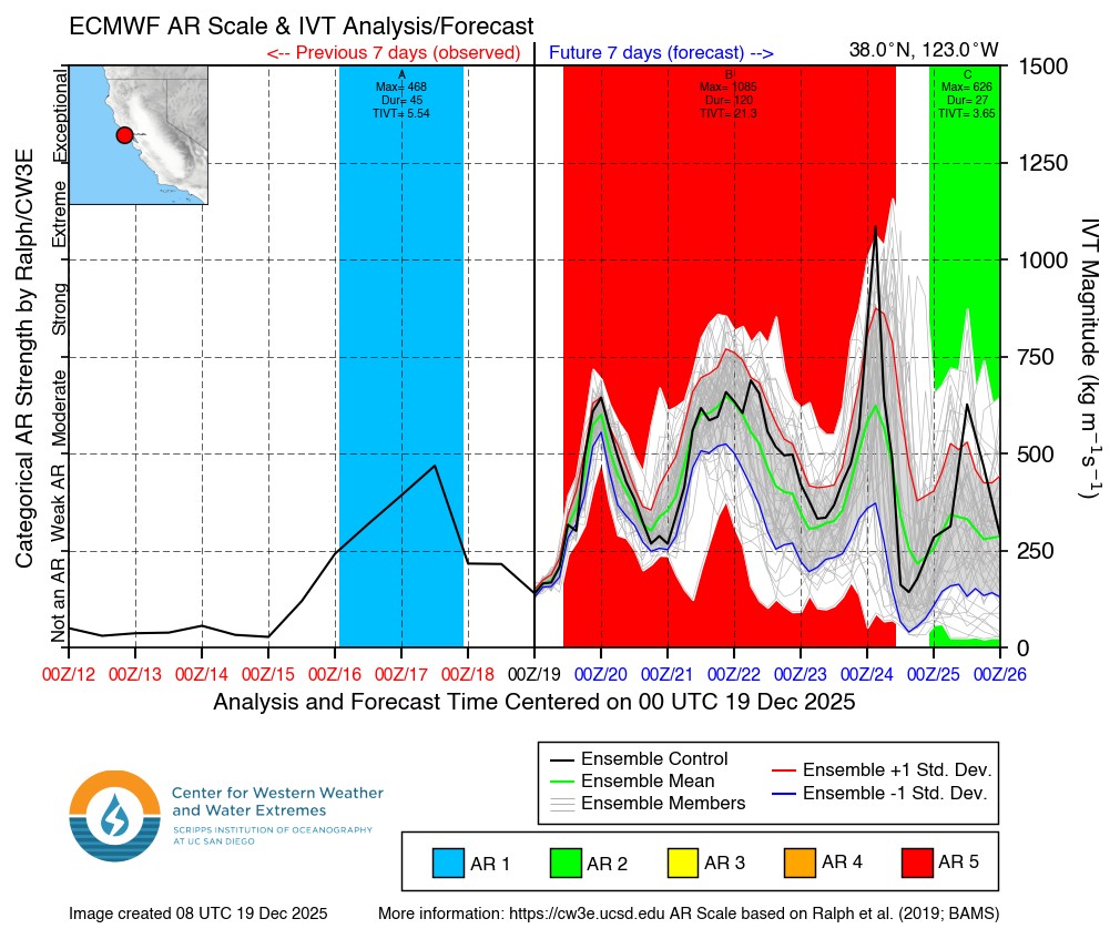
“High risk” for damaging SoCal flooding
Today, showery weather dominates parts of central and northern California. The next firehose of moisture will increase tomorrow, aimed at northwestern California to start, but dropping south into the Bay Area tomorrow evening and into SoCal tomorrow night and Christmas Eve morning. A second wave of storminess will follow Wednesday night and Christmas morning. These systems are going to cause some serious flood concerns in parts of California. Given the trajectory of moisture perpendicular to the west-east mountains in the LA Basin, this is going to dump a lot of rain. And it looks like minimal to no snow for the San Gabriels or San Bernardino Mountains during the peak of the precipitation.

A high risk was issued this afternoon for Southern California for flash flooding for Wednesday. High risks are well correlated to flood damage, and the fact that they’re confident enough to update the day 3 outlook to high is slightly concerning. There are three main elements of flooding concerns: Urban flooding in the LA Metro, debris flow issues from burn scars, particularly the Eaton and Palisades fire footprints, and flooding due to torrential rain in the mountains and hills. Overall, this looks like a serious flooding setup in SoCal, and it should be taken very seriously.
In addition to the heavy rain in Southern California, wind gusts over 40 mph are possible in some of the valleys and higher gusts up to 80 mph or so in the mountains.
And then there’s the snow. While the SoCal mountains will be dusted only at the end of the event, the Sierra will see snow levels down to 4,500 feet or so, which will allow for several feet of snow to accumulate, including perhaps as much as 4 to 8 feet above 5,500 feet.
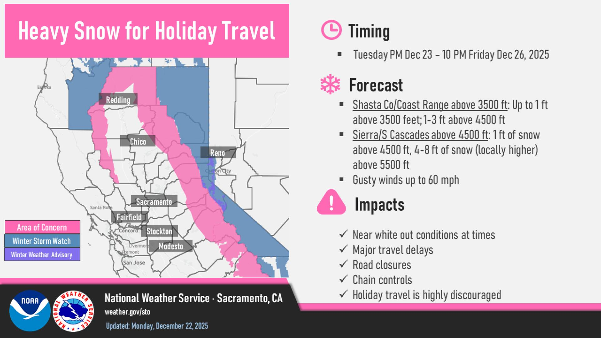
Precip will continue into Friday across the state with colder air. Overall, this will be the highest impact storm of the season so far in much of California.
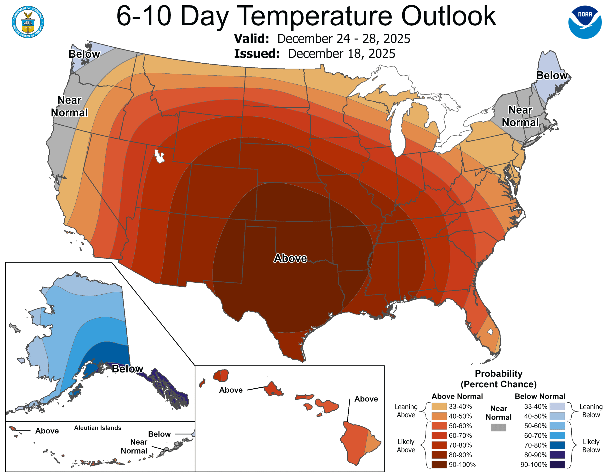
Warmest Christmas ever for many
Well, the good news is that a little bit quieter weather is on the way after the system flushes out of Cali this weekend. Atmospheric river events may pick back up again toward New Years, starting up in the Northwest or British Columbia, then tracking southward with time again.
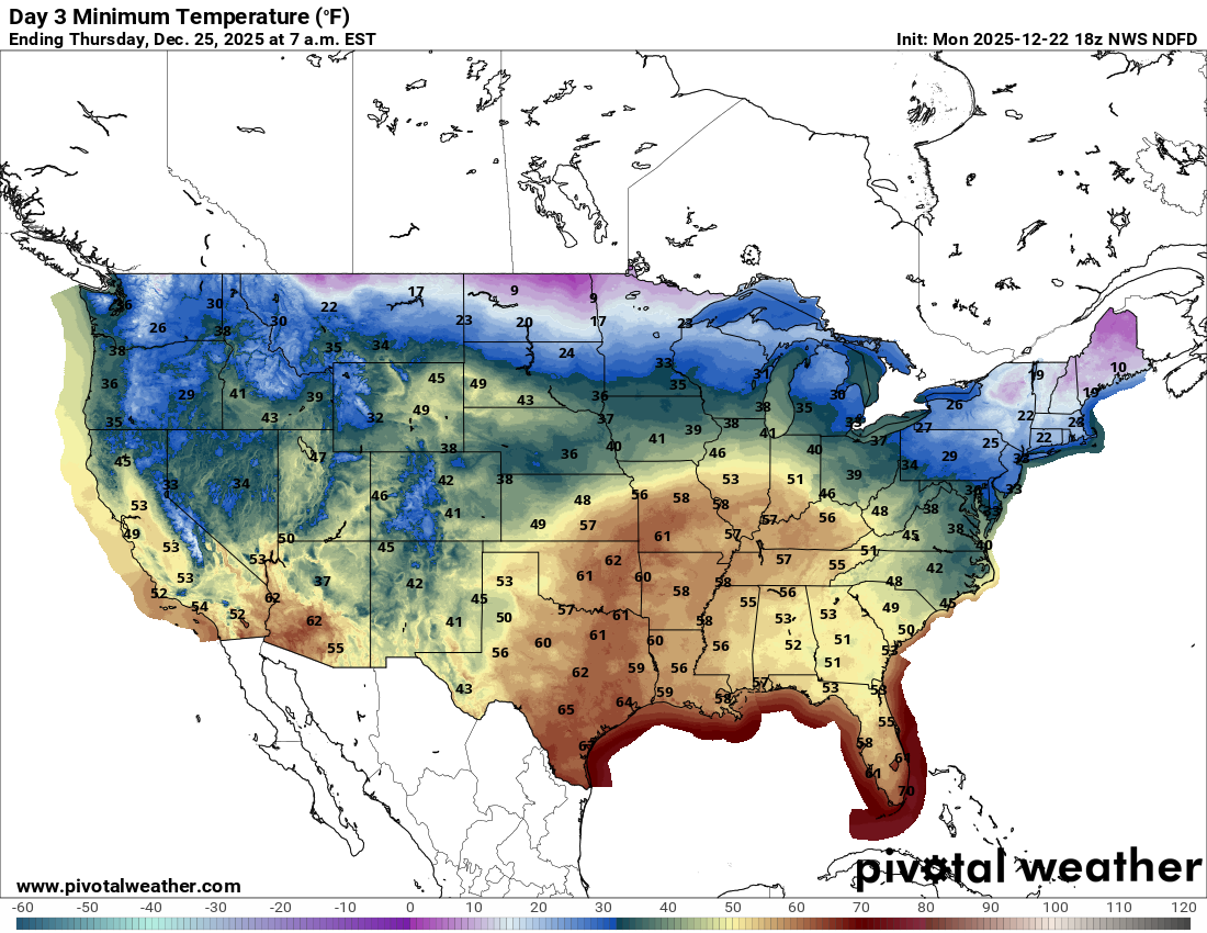
Meanwhile, the focus is on warm weather, record warm weather. Dozens of record highs will fall this week, with Christmas Day clocking in as one of the warmest on record in many parts of the country.
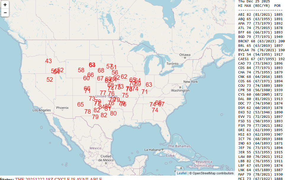
Some of these records will be obliterated, including Wichita (record: 68° in 2019, forecast 76°), Childress, TX (record 77° in 1971, forecast 84°), and Kansas City (record: 67° in 1922, forecast 73°). In addition to record highs, nearly 70 locations are forecast to have their warmest low temperatures on Christmas morning on record. My favorite? Harrison, Arkansas, which is forecast to be 61° on Christmas morning, 12 degrees warmer than the previous record set in 2019 (records going back to 1892). Oklahoma City isn’t far off, expecting to break their warmest record minimum temperature by 10 degrees on Christmas morning. If you like your Christmas’s feeling like Christmas, try again next year. Or go to the Dakotas or New England.
Newsy bits
Indonesia: A weird situation in southeast Asia, which has been battered this autumn by floods. A lot of humanitarian aid being sent to parts of Indonesia has either had to be returned or diverted elsewhere because of government issues. Suffice to say, people are not happy. (Asia News Network)
Washington State: Much like we saw in Alaska after the remnants of Halong earlier this autumn, federal money earmarked for disaster has been held up by the Trump Administration, including $182 million in Washington State for flood mitigation. This has been a bit of a theme of late. To be clear, this probably would not have helped with the recent flooding, but it serves as a reminder that vital work for mitigation around the country is being held up for ambiguous reasons. (NBC News)
Colorado River: We aren’t getting any closer to a deal on cuts to water in the differing, sometimes warring basins on the Colorado River. It seems like this is either headed for litigation, a federal directive, or some sort of temporary stopgap measure to buy a little more time. Either way, this does not bode well for anyone. (Inside Climate News)
Florida: A new paper published in AGU’s Geophysical Research Letters by a group of heavy hitting tropical meteorologists discusses the recent increase in Florida Gulf Coast landfalling hurricanes, while there has been a void of much action on the East Coast of Florida. The authors believe that the combination of climate mode variability from teleconnection patterns via El Niño/La Niña, the North Atlantic Oscillation, and the Atlantic Multidecadal Oscillation can explain a significant amount of the Gulf variance but not the Atlantic Coast variance. Basically, a combination of bad seasonal and annual scale factors likely increased the odds of Gulf Coast impacts from tropical systems in Florida. (AGU)
U.S.: A preprint from scientists at Villanova examines geospatial risk of tropical systems in the U.S. As it turns out Harris County, TX (Houston) and Cameron County, TX (Brownsville) have the highest disaster risk from hurricanes in the country. Several counties in Florida, as well as much of New York City ranks high on this list, much due to socioeconomic factors, vulnerability, and resilience. (Research Square)