Debby’s downpours to deluge portions of Georgia and South Carolina after making landfall in Florida as a hurricane

Headlines

  • Tropical Storm Debby is slowly intensifying off the west coast of Florida, with about 18 to 24 hours to go before making landfall in the Panhandle or Big Bend area, likely as a strengthening category 1 hurricane.
  • Debby will slam on the brakes as it comes inland leading to widespread, potentially historic flooding in coastal Georgia and South Carolina.
  • Storm surge with Debby is expected to be serious and fall just under Idalia’s levels in the Big Bend of Florida.
  • There are two additional tropical waves we are monitoring for development next week.
Debby’s forecast track over the next 5 days. (Tomer Burg)

Tropical Storm Debby: 60 mph, NNW 13 mph

Tropical Storm Debby continues to gradually organize off the west coast of Florida this morning, now a more formidable tropical storm.

Debby is slowly organizing off the west coast of Florida. The storm has about 18 to 24 hours left over water to intensify. (Tropical Tidbits)

The bad news is that Debby continues to organize, but I suppose the good news is that it does continue to have some inhibiting factors, chief among it, dry air on the west side of the storm. This will likely be a subtle player in keeping Debby from totally maxing out its intensity potential. That said, Debby is still expected to make landfall in Florida near or just west of the Big Bend as a strengthening category 1 hurricane (similar in some ways to Beryl in Texas last month). This is important for much of that area, and specifically for the Tallahassee metro area in terms of potential widespread power outages. Debby’s exact track will help determine that.

Debby’s storm surge

Starting first with surge, the expectation is that 6 to 10 feet of water could come in along the coast of the Big Bend with Debby’s current track.

Debby’s peak surge forecast on the Florida coast and beyond. Values look to be a bit under Idalia last year, but still capable of producing life-threatening conditions and significant damage. (NOAA NHC)

These values are less than were forecast during Hurricane Idalia last summer, but still extremely dangerous. Again, keep in mind that Debby is likely to be strengthening on approach whereas Idalia was weakening on approach. There may be more similarities between the two storms than expected and just because this one is “only” a category 1 storm should not factor into your preparations. Conditions will deteriorate today, so please heed the advice of local officials.

Debby’s track and wind

Debby is expected to come ashore just west of the Big Bend as a strengthening Cat 1 storm. While I noted some dry air above helping to limit Debby’s maximum potential, the biggest limiting factor for Debby may be time. Debby should come ashore in Florida late tonight or early Monday morning, so it has about 18-24 hours left to do whatever it will do.

Debby’s strongest winds will impact the coast of Florida from about Apalachicola through Cedar Key, with potential for significant wind into Tallahassee depending on the exact track. (NWS)

Squalls and bands from Debby will impact Florida’s west coast today, including Tampa with some gusty wind and heavy rain. The worst wind and rain will likely occur from Tallahassee eastward.

Beyond the Big Bend, Debby’s forecast track becomes extremely uncertain. In general, we expect Debby to slam on the brakes and drift northeast, then east-northeast, then, well your guess is as good as ours right now. There are questions as to whether Debby emerges off the East Coast, meanders around so erratically that it ends up back in the Gulf, or perhaps it even just drifts north into eventual oblivion. This leads us to our next issue.

Debby’s potentially historic flooding

Debby is a hurricane first and foremost, and we’re obviously concerned for Florida. That said, the most obvious threat from Debby continues to be flooding rainfall.

As much as 20 to 30 inches of rain is expected from Debby on the coast of South Carolina and Georgia through the upcoming week, likely leading to widespread, potentially catastrophic flooding. (NOAA WPC)

We are now entering some historic territory with Debby’s rainfall forecast. 20 to 30 inches of rain is now expected between Savannah and Charleston, SC, including Hilton Head. This will cause widespread, possibly catastrophic flash flooding, urban flooding, and river flooding in coastal Georgia and South Carolina. The worst will likely be south and east of I-95, but significant flooding concerns will also exist back toward Columbia, SC, Augusta, GA, possibly up toward Myrtle Beach and into southeastern North Carolina as well.

The standing record for rainfall from a tropical system in South Carolina is 23.63″ from Florence in 2018. Joaquin in 2015 aided in over 26″ as well, so we are currently forecasting that rain totals may approach these record levels. For Georgia, the standing record is almost 28″ during 1994’s Tropical Storm Alberto. Whether it’s a record or not, there are unique aspects to this event, including the potential for coastal flooding to exacerbate flooding conditions in places like Savannah, Charleston, Hilton Head, and Myrtle Beach.

I cannot emphasize enough how serious of a flooding threat this is for southeast Georgia and coastal and Lowcountry portions of South Carolina. Please ensure folks in these areas are prepared for this potential.

As always, isolated tornadoes are a possibility as Debby comes ashore.

So, in summary:

  • Debby is a historic, potentially catastrophic flooding threat for coastal Georgia and South Carolina.
  • Debby will make landfall as a hurricane late tonight or Monday morning near or just west of Florida’s Big Bend.
  • Debby will meander for several days, with uncertainty higher than usual on where exactly it ends up.
  • Debby will cause damaging storm surge in the Big Bend of Florida, just under Idalia’s levels from last year.

Elsewhere in the tropics

A quick note on the rest of the tropics this morning. We currently have two tropical waves worth watching. One is entering the Caribbean today, while the other sits just off Africa.

We are monitoring two additional tropical waves in the Atlantic that may try to develop over the next week or so. Little clarity exists on exactly how that may unfold, however. (College of DuPage)

The National Hurricane Center has 20 percent odds for the Caribbean wave to develop as it meanders west. Some modeling does try to allow it to gain some latitude eventually, so I would say we should keep an eye on this one. Same with the one behind it that will be moving into an Atlantic that should be modestly more hospitable for tropical development. We’ll continue to watch. For now, no specific area should be worrying, but it’s now time to check in on the tropics every day or two from now through September or October.

Tropical Storm Debby forms, poised to track into Florida and then unleash copious amounts of rain on Georgia & South Carolina

Headlines

  • Tropical Depression 4 is now Tropical Storm Debby.
  • Debby is expected to track toward the Panhandle or Big Bend of Florida as a strong tropical storm or intensifying Category 1 hurricane Monday.
  • Copious amounts of rain will follow Debby into Georgia and South Carolina where significant flooding may unfold.
  • Debby’s exact track beyond Monday or Tuesday is highly uncertain.
  • There is another wave beyond Debby worth monitoring next week.
Debby’s latest forecast at 5 PM ET shows a broad northward move, followed by a shift to the east and a sharp slowdown in forward speed. (NOAA NHC)

Tropical Storm Debby: 40 mph, NW 15 mph

Well, here we go again on the west coast of Florida, with another system that will generate some headaches in terms of track. This afternoon, newly minted Tropical Storm Debby looks reasonable. The center shows up nicely on visible satellite, and there is plentiful thunderstorm activity surrounding all sides of the system. As this lifts northward into the Gulf and gets out of the way of Cuba, I suspect we’ll begin to see some consolidation and steady intensification of this one.

Tropical Storm Debby late on Saturday afternoon shows lots of thunderstorm activity and a pretty well defined circulation. (Tropical Tidbits)

The current intensity has it sitting around 40 mph maximum sustained winds, hence the upgrade to a tropical storm. Debby is large in size, (not quite a “Little Debby”) which means it may take a little effort to strengthen. Debby should become a formidable tropical storm, if not a category 1 hurricane before coming ashore. Hurricane warnings are now posted from the Suwannee River to the Ochlockonee River on the Florida Gulf Coast. Tropical Storm Warnings are posted for the west coast of Florida into the Keys. Storm Surge Warnings are in effect between Aripeka north to Indian Pass.

Debby’s track

Debby will be steered north and northeast in between two ridges and in the direction of a trough over the East Coast. Arguably, the track forecast for Debby has the least uncertainty over the next 48 hours or so, and most modeling is in good agreement on that.

European ensemble members show strong agreement on Debby’s general track north and northeast-ward over the next 48+ hours, coming ashore in the Big Bend or Panhandle of Florida. (Weathernerds.org)

After Debby comes ashore somewhere in the Big Bend or Panhandle, that’s when forecast confidence begins to nosedive a bit. A generally slow east or northeast drift to Debby’s motion should set in. But exactly whether or not that gets Debby back offshore and with an ability to try and restrengthen off the Georgia or South Carolina coasts remains to be seen. Expect a very erratic motion to Debby after Monday.

Debby’s intensity

As noted above, there is some chance that Debby can become a hurricane before it comes ashore in the Big Bend or Panhandle Monday morning or so. The obvious comparison for this storm will be Idalia from last year. Idalia made landfall as a weakening category 3 hurricane with 125 mph maximum sustained winds. Debby is likely to make landfall not far from where Idalia did but as a strengthening tropical storm or category 1 hurricane. Much like we witnessed in Houston and coastal Texas last month with Beryl, there are elements about strengthening category 1 storms that are often underplayed ahead of time. Folks in the Panhandle and Big Bend should be taking Debby seriously and listen to local officials in terms of evacuation orders or preparedness recommendations.

After landfall, Debby will lose some of its intensity, though some locally strong winds are possible across south Georgia or North Florida as it turns east. Again, the big wild card right now is what Debby does when it approaches the Georgia coast and makes an effort to get offshore.

Debby’s rainfall

While folks on the Florida coast need to be preparing for a strengthening category 1 hurricane, people across North Florida, Georgia, and the Carolinas need to be preparing for a potentially major rain and flooding event.

Debby is likely to bring copious amounts of rain, flooding, and flood damage to Georgia and South Carolina heading into next week. (NOAA WPC)

The very latest rainfall forecasts is suggesting anywhere up to 12 to 20 inches of total rain from Debby on the coast of Georgia and South Carolina, including Savannah, Hilton Head, and Charleston. This has the potential to also produce a wide swath of 8 to 12 inch rains in the Lowcountry of South Carolina and much of southeast Georgia (as well as parts of North Florida) also. Combine this with rough seas and high tides, and we could be looking at an especially dangerous, damaging flooding scenario in coastal spots and a significant, locally damaging flooding event away from the coast. Heavy rain will extend up to North Carolina at times as well, but we are really concerned with South Carolina and Georgia first in this scenario. Slow moving tropical systems loaded with abnormally high amounts of atmospheric moisture are never a good combination. Please take this threat extremely seriously in those areas.

How long the rain lasts and how far north it gets remain questions to monitor over the next few days.

So, in summary:

  • A strong tropical storm or intensifying category 1 hurricane is likely to turn into the Big Bend or eastern Panhandle of Florida by Monday.
  • Debby will slow down as it tracks across Georgia and North Florida, delivering copious amounts of rain to Georgia and South Carolina.
  • A major flooding threat exists, particularly along the coast, including Savannah, Hilton Head, and Charleston.
  • Debby’s future remains a bit uncertain beyond that, and folks in North Carolina should continue to monitor the system’s progress in the days ahead as well.

Some quick miscellany

First, we have people wondering why we are on Debby and not Chris. Well, if you blinked, you missed Tropical Storm Chris. It formed for about 8 hours before coming ashore in Mexico in early July. This occurred while Beryl was hammering the Caribbean, so it obviously got lost in the shuffle.

Second, we are monitoring another tropical wave behind Debby. This system has shown up on various deterministic/operational model guidance at times as a formidable Gulf storm. Remember, we try not to use deterministic guidance 10 days or so out, as it is prone to wild and extreme variability run to run. Looking at ensemble guidance is more useful, and in this case, we have decent European ensemble agreement on something in the western Caribbean or near Cuba again in about 6 days.

Behind Debby, another tropical wave is beginning to generate buzz, but it’s too soon to say much of anything coherent about this one’s future. (Weathernerds.org)

For now, we’ll wait for Debby to get out of the way and then focus on that as well.

Tropical wave with decent chance of development this weekend continues plodding toward the southwest Atlantic

Headlines

  • Slow development of the Atlantic tropical wave is likely this weekend near the Bahamas.
  • The track of the system is highly uncertain with some plausible outcomes ranging between the eastern Gulf and offshore of the East Coast.
  • Interests from Louisiana to Florida to the Carolinas should continue to monitor the progress of this system, even though current expectations are not for a major storm.

It’s a slow go from the Atlantic wave

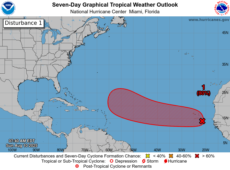
We continue to track a tropical wave in the open Atlantic this afternoon that the National Hurricane Center continues to gradually beef up development odds on. This afternoon they stand at 60 percent over the next 7 days (near zero the next 2 days).

Development odds in the Atlantic have increased to 60 percent over the next week. (NOAA NHC)

This is a larger, lumbering wave with slowly increasing thunderstorm activity. Larger waves are generally slower to develop, and given how much dry air this thing still has to shed, we likely won’t see any real movement toward organization until this weekend. But compared to Monday it certainly looks better I guess.

The thunderstorms (blue/green) are still few and the dry air (red/orange) still plentiful in and around the tropical wave in the Atlantic. (Weathernerds.org)

We should see a touch more in the way of storminess around this wave tomorrow and again on Thursday. Once we get to Friday or Saturday and this approaches the Bahamas, that’s when we could finally begin to see organization.

From that point, this wave’s future is cloudy. If you dig into the European ensemble’s 51 members, you can actually get a good picture of the possible outcomes. No ensemble spread is perfect, but this gives you a very high level understanding of the generic possibilities that exist with this wave. I’ve broken them into 3 camps below.

Three general possibilities with the upcoming tropical wave as it approaches the Bahamas and Florida. (Weathernerds.org)

On the right, we have the more aggressive solutions, which include the Euro operational and ICON models at present. These quickly strengthen the wave in the Bahamas such that it gets pulled north by a trough, generally remaining offshore, away from land and probably not a huge deal for anyone. This solution seems a bit overaggressive to me, so I’d say odds of this are relatively low. But it’s a possibility.

In the middle, you get the general consensus view of the Euro ensemble which is a storm that only slowly strengthens and organizes, still enough to turn it north, but not before it gets closer to Florida and the Bahamas and potentially close enough to eventually threaten the Carolinas. In this case, you still probably wouldn’t have a particularly strong storm, but you’d have something a little better organized than just a wave or depression. European A.I. modeling also supports a hybrid of this outcome and the previous one, closer to the coast but still offshore.

Then, on the left, you have a small cluster of a couple ensemble members that do not develop the wave at all and allow it to continue west or west-northwest into the eastern Gulf of Mexico. Eventually it would probably still turn north, but because the upper air pattern steering this thing would be fairly convoluted next week, any confidence in where that happens would be quite low. Still, this would likely only gradually organize in this scenario. The GFS operational model supports this outcome at present. Notably, that model also places a little mid-level system ahead of the tropical wave which would probably boost wind shear a bit and could help direct it north a little faster. Maybe. It’s complicated.

What does it all mean? They’re scenarios for a reason. Is one more likely than the other? Well, the middle one seems to have more support among modeling. The GFS is sometimes a bit wonky with these things, so I’m not sure I entirely buy the Gulf scenario. And it’s noteworthy that despite the expected slow organization of this system, between warm water and extremely low wind shear, conditions look pretty good for some strengthening near the Bahamas this weekend.

Wind shear is expected to be minimal over the tropical wave this weekend in the Bahamas, with most meaningful shear well east of it on Saturday. (Tropical Tidbits)

The meteorologist in me favors some combination of the Euro op’s quicker strengthening and the middle majority cluster right now. This would yield minimal direct impacts. But the public communicator in me must tell you that interests from Louisiana through the Carolinas should continue to monitor the progress of this tropical wave. Even if it’s not currently expected to be a significant storm, it will have a few things going for it as it organizes.

In summary:

  • Slow organization is expected this weekend near the Bahamas.
  • The track is uncertain, with some modeling quickly strengthening the wave and turning it out to sea, while other modeling brings it closer to Florida or the Carolinas and even a few not forming it at all, bringing it into the Gulf.
  • At the least, a tropical system should form, but where and when exactly remains to be seen.
  • Interests from Louisiana and the Carolinas should continue monitoring the progress of the wave in the coming days.
I will be out of pocket the next few days for some medical stuff, but Eric has you covered going into the weekend!

As we await the Atlantic’s awakening, a tropical wave without thunderstorms is what we’re watching

Headlines

  • The tropical wave in the Atlantic is unlikely to develop before at least Friday.
  • Development after Friday should be slow as it moves toward the Bahamas.
  • From there, numerous questions about which will determine if this system can up in the eastern Gulf or turn north off the Florida coast and where it goes from there.
  • Interests between eastern Louisiana and the Carolinas should check in on this again in a day or two.

A dry tropical wave for now

You hear the term “tropical wave” tossed around by meteorologists and others all hurricane season long. But what is it, exactly? By definition, a tropical wave is “an inverted trough (an elongated area of relatively low pressure) or cyclonic curvature maximum moving east to west across the tropics.” Nothing in that definition says thunderstorms or rain or anything like that. So, yes, in theory some tropical waves can be dry.

When we look at the central Atlantic today on the traditional satellite imagery, we don’t see a whole lot that’s perceptible. There’s a wave there, sure; you can see some cyclonic curvature. When you look at water vapor satellite imagery, you can see it even a bit better, but where you see browns, reds, and oranges, that indicates the presence of a lot of dry air. Use the slider below to toggle between a visible and water vapor image of the central Atlantic wave this afternoon.

Visible satellite imagery in black and white, and water vapor imagery with lots of red, orange, and brown indicating the presence of dry air in the central Atlantic. (weathernerds.org)

What does this tell us? It says that the tropical wave in the Atlantic is not going to develop anytime soon into a formal tropical entity. However, the presence of a tropical wave indicates that once it can shed some of this dry air, perhaps then we could see slow development. That may not be til Friday or the weekend.

Modeling continues to indicate the potential that the slow development noted above could occur as the wave comes west northwest toward the Bahamas or Turks and Caicos late this week or weekend. Clearly, it’s dealing with dry air and Saharan dust right now, but once it gets to the west, north of Puerto Rico by Thursday morning it will begin to likely increase moisture presence.

The overnight run of the European model shows this tropical wave adding moisture by the time we get to Thursday morning when its north of Puerto Rico. (Tropical Tidbits)

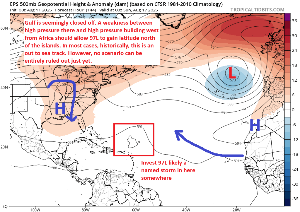
For the Lesser Antilles, Virgin Islands, and Puerto Rico, this system is unlikely to cause much heartburn. After Thursday, the system will continue to the west-northwest into the Bahamas. The overall atmospheric setup by Saturday as forecast by the European model is fairly complex, and as usual the ultimate path of this wave, depression, storm, whatever it is will be contingent on its strength as well as the exact location of these features. But at this point, I can count three big players: High pressure in the Atlantic, high pressure over Texas and the Plains, and a sharp trough of low pressure digging into the Ohio Valley and Appalachia.

Tropical wave over the Bahamas on Saturday will be steered west and northwest around high pressure in the Atlantic, tugged north by a sharp trough in the Eastern U.S., and likely slowed a bit by high pressure over Texas and the Plains. (Pivotal Weather)

The interplay that the Euro is “seeing” here right now appears to be that the wave slows on approach to Florida. It is being steered by the high to the east, but it slows as it runs into the influence of high pressure over Texas (the arrow pointing down) and also as it “feels” the trough over the Eastern U.S. trying to pull it north. It’s tough to speculate much on exactly what happens here. A weaker system would probably keep drifting west into the Gulf, whereas a stronger one would be more apt to turn northward in the Bahamas and possibly stay off the Florida coast. Most European ensemble members have supported this stronger idea, and you can see today’s 12z probabilities of a tropical depression from the ensemble favoring the “off the East Coast of Florida” idea.

The bulk of the European ensemble model guidance seems to favor a track of the tropical wave east of Florida, but sketchy beyond that as it comes north. (Weather Bell)

Beyond Florida, even in a faster turn scenario, all bets are off because the upper pattern may get a bit convoluted next week. An out to sea turn is not inevitable by any means in that scenario. Likewise, if a weaker storm sneaks under the trough and ends up in the eastern Gulf of Mexico, interests between Louisiana and the Florida Big Bend may be on notice too.

So, to summarize:

  • Tropical development is not expected before Thursday or Friday at the earliest.
  • Development is likely to be slow, though with exceptionally warm waters, any risk of development should be treated with respect.
  • The best guidance we use favors a slowing in the Bahamas, followed by a turn north near or off the coast of Florida.
  • However, given the very high uncertainty with regard to the speed of development and the precise location of steering features, any track forecast is low confidence and interests between Louisiana and the Carolinas should continue to monitor this system’s progress.

Elsewhere, no further tropical development is expected before mid to late next week, but we continue to look toward mid-August as the Atlantic inflection point, and activity may begin apace by then.