In brief: Invest 91L in the Bay of Campeche may develop into a depression, but it probably won’t get much farther than that. Invest 95E in the Pacific is likely to become the next tropical storm or hurricane there tracking up and off the coast of Mexico. Both will bring heavy rain to either coast of Mexico. Plus, we have the latest on the loss of microwave satellite imagery.
Invest 91L
We have our second “invest” of the season. Just to refresh people’s memories, “invests” are just when meteorologists at the National Hurricane Center tag areas of investigation. It’s mostly meant so we can start running some tropical models on a particular area. It doesn’t mean a storm will or won’t develop. It’s just a nice way to classify these things in the pre-storm phase.
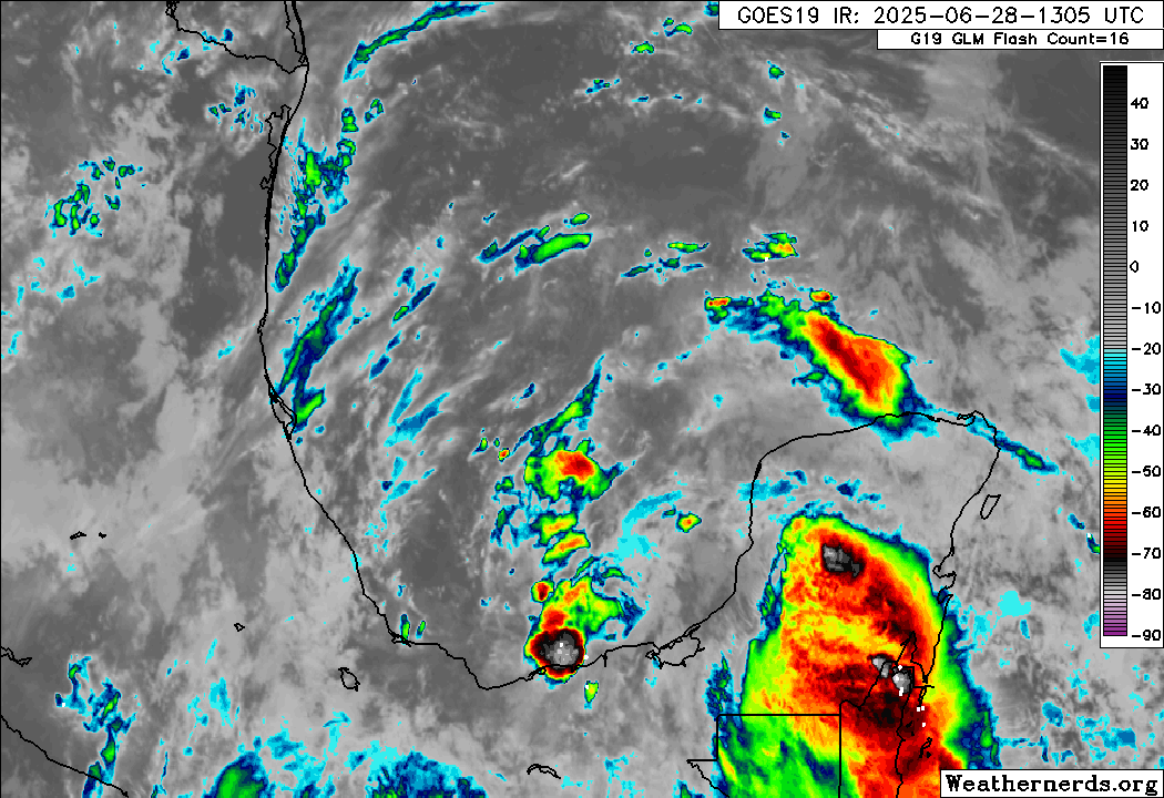
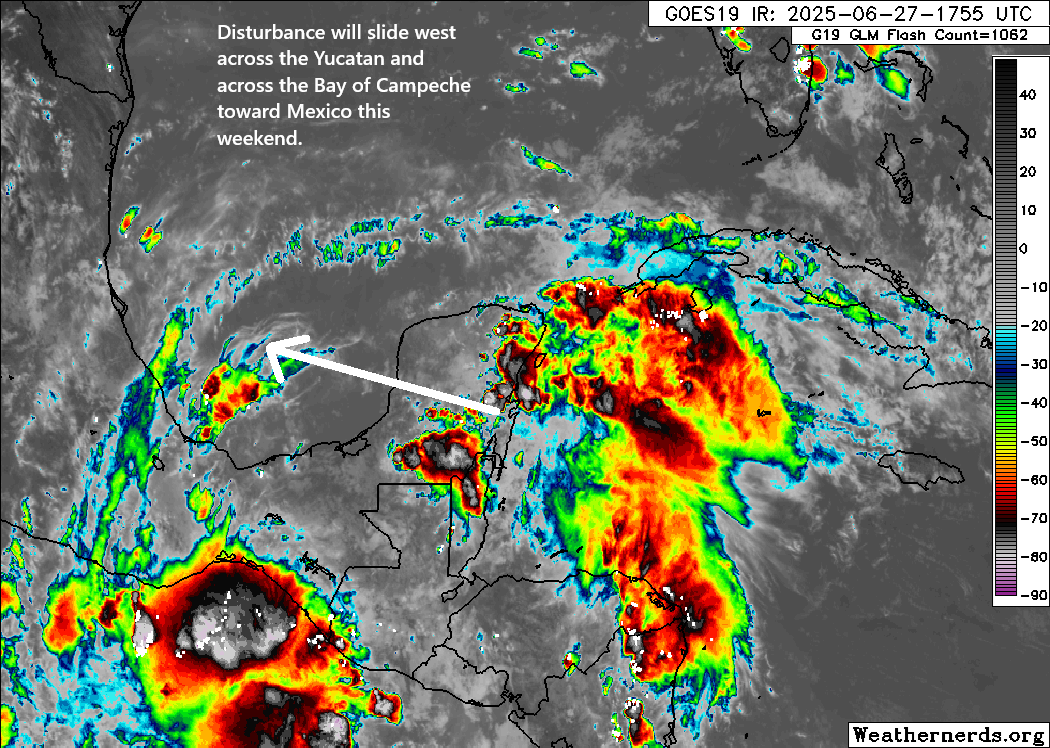
Anyway, Invest 91L got tagged late yesterday, and today it’s emerging as expected into the Bay of Campeche.
Invest 91L is dealing with some issues with thunderstorm development today. (Weathernerds.org)
Truthfully, it looked better yesterday, but after traversing the Yucatan, it should not be too surprising to see it struggling a bit. It’s also not as if wind shear is zero here either. There’s a fair bit of it still, which could limit its chances of becoming a depression or named storm. This is a case where the impacts are a lot clearer than the technical definition of the thing.
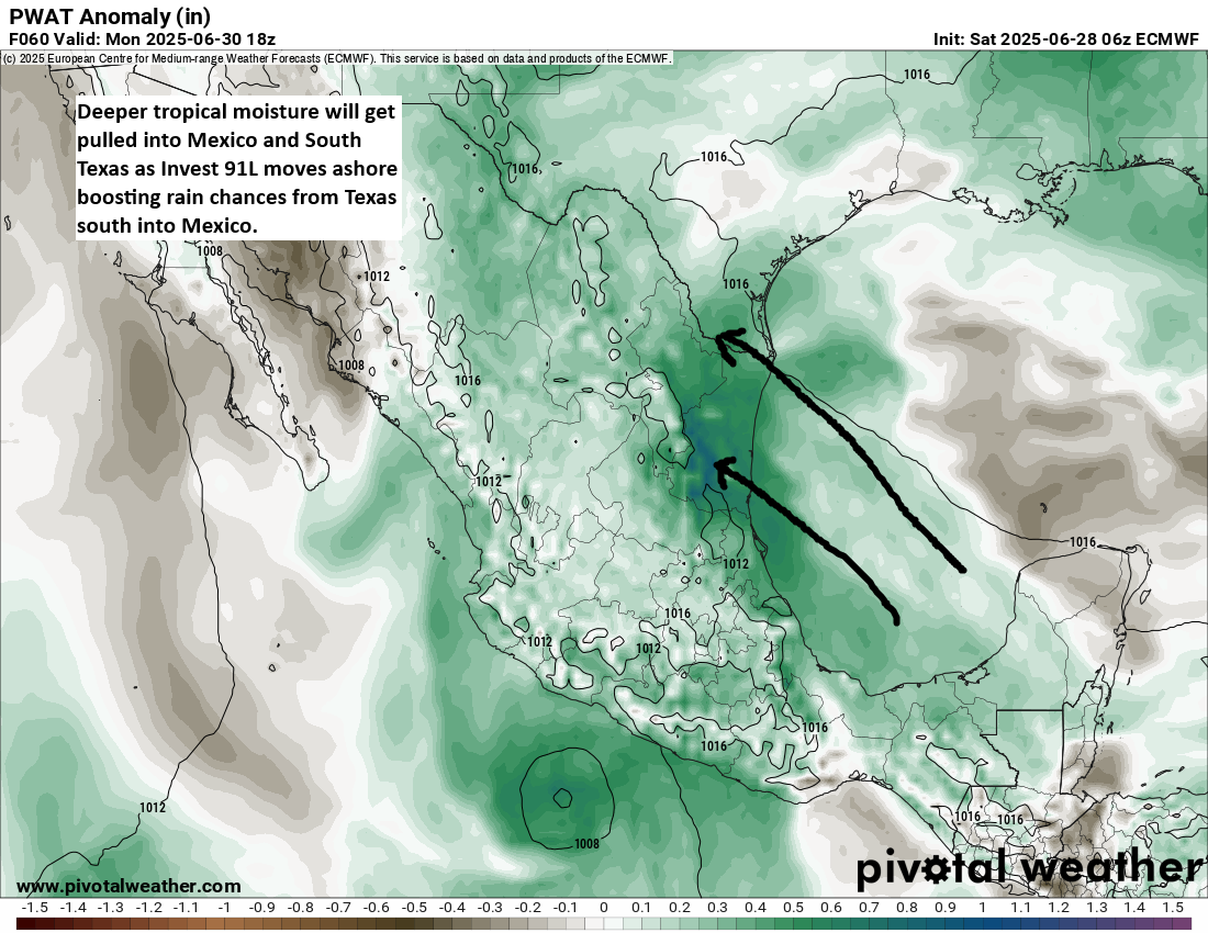
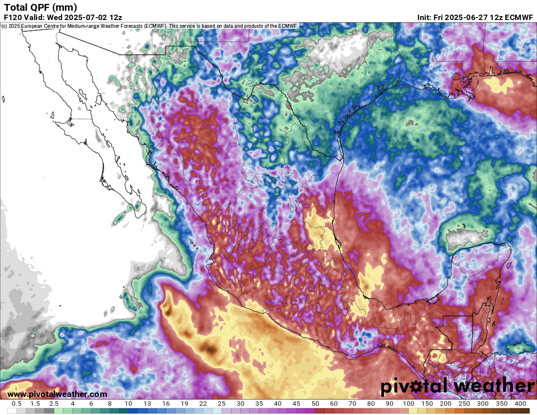
Indeed, those impacts will include some rough seas in the western Gulf, as well as heavy rainfall. Deep tropical moisture is going to get yanked north and west as 91L moves inland over Mexico tomorrow night and Monday.
Tropical moisture will boost locally heavy rain and flooding chances from Texas into Mexico. (Pivotal Weather)
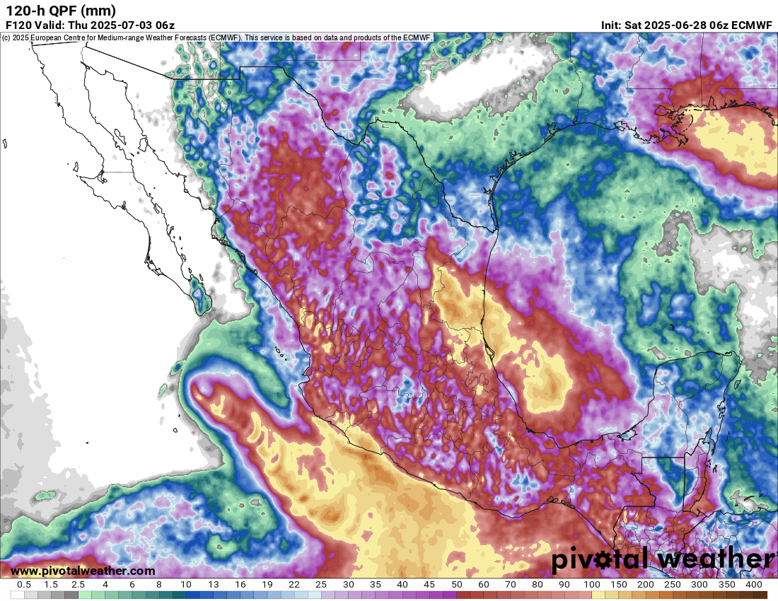
Rainfall is forecast to add up to 4 to 8 inches (100-200 mm) in parts of Mexico, with lower amounts in Texas over the next 5 days. That said, even up in Texas, there will almost certainly be locally heavier rainfall totals that show up, especially from Matagorda Bay south through Corpus and Brownsville.
Rain totals of 100-200 mm expected over the next 5 days in Mexico. (Pivotal Weather)
So the main concern from Invest 91L will clearly be heavy rain and flooding potential, particularly in Mexico. High pressure should build in later this week behind 91L to dry things out a bit.
Invest 95E a west coast of Mexico concern
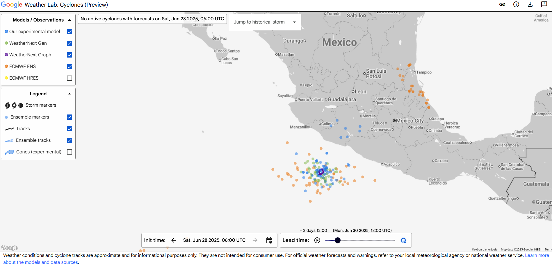
Meanwhile, in the Pacific, we have Invest 95E, which will be a rather interesting system for Mexico’s west coast. It should take a track up along the coast but offshore. However, this will likely expose much of the coast from Zihuatanejo north to Baja to tropical impacts as the system develops. And some modeling is actually rather robust with the intensity forecast of 95E.
Google Weather Lab’s screenshot of their various AI model and European ensemble forecast positions of Invest 95E valid on Monday afternoon. (Google)
It should be far enough offshore to keep the worst impacts out at sea, but there are certainly a handful of model solutions that bring this close enough to the coast to produce consequential impacts. You can see from the rainfall map above under the section about Invest 91L that even the west coast of Mexico will see substantial rain over the next 5 days as a result. By the time this does reach Baja and Cabo, it should be weakening under the influence of much colder water. So hurricane impacts are not expected that far north, but locally heavy rain will be a concern. Some of that remnant moisture could get pulled into the Desert Southwest by about next weekend and help enhance monsoon thunderstorms a bit.
Elsewhere
Nothing new to report today elsewhere, including next weekend’s potential in the northeast Gulf or southwest Atlantic, which looks no scarier or likelier today.
Regarding yesterday’s post about the cuts to microwave satellite imagery, which sparked some spirited comments, please keep in mind that nothing about the post was politically motivated or biased. The actual fact of the matter is that we are living in a new reality that did not exist a year ago in the weather community (wide NWS cuts, wide reduction in weather balloon launches, budget requests to eliminate departments that serve the broader weather community, and more), and it’s incumbent on us to make sure people are aware of what is happening based on the facts, which we laid out yesterday.
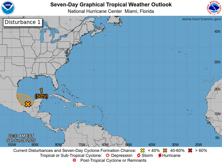
In brief: A system moving toward the Bay of Campeche has about a 30 percent chance of developing before it moves ashore in Mexico later Sunday or Monday. Another system in the northeast Gulf may emerge by late next week with low odds of developing a little. Plus, we answer questions surrounding the expected loss of a major satellite tool used in hurricane forecasting.
Bay of Campeche
There is a disturbance sitting off the Yucatan as of Friday morning. This is expected to cross the Yucatan and emerge into the Bay of Campeche this weekend. From there it should continue to press west or west northwest into Mexico. Does it have a chance to develop? Certainly; the National Hurricane Center currently assigns about 20 percent odds of it doing so.
An early afternoon satellite image of the disturbance approaching the Yucatan shows little to no organization but plenty of thunderstorm activity. (Weathernerds.org)
However, realistically, this has such a limited time over water with minimal organization that even if something began organizing, it would run into the wall that is mainland Mexico by Sunday or Monday. Thus, any development is both low and with a low ceiling for intensity. That said, this disturbance will bring some heavy rain to Mexico this weekend and early next week.
Five-day rain totals in eastern Mexico tally up to over 100 mm of rain (~4 inches)
But in terms of concern priorities, it’s low.
Northeast Gulf late next week
We continue to see signs in modeling that another disturbance will emerge in the northeastern Gulf by later next week.
The system will pinch off of a dying cold front that stalls out in the northeast Gulf and off the Southeast coast. Look for unsettled weather to setup in the northeast Gulf by late next week, likely bringing some continued heavy rain risk to parts of Florida and the Gulf Coast. But will it develop beyond just periodic thunderstorms? It’s too soon to say, but there is a subset of weather modeling that points to this.
A handful of the 51 European ensemble members show a tropical system of generally low intensity near the northeast Gulf or off the Southeast coast next weekend. (Weathernerds.org)
This is not what I’d call “strong agreement,” but it’s something I suppose. I think the most likely outcome here is that we get a disturbance that festers for a few days off the west coast of Florida or even over Florida itself and then gradually exits out to sea. Development odds seem fairly low overall, and I would presume that overall conditions would be hostile for significant organization.
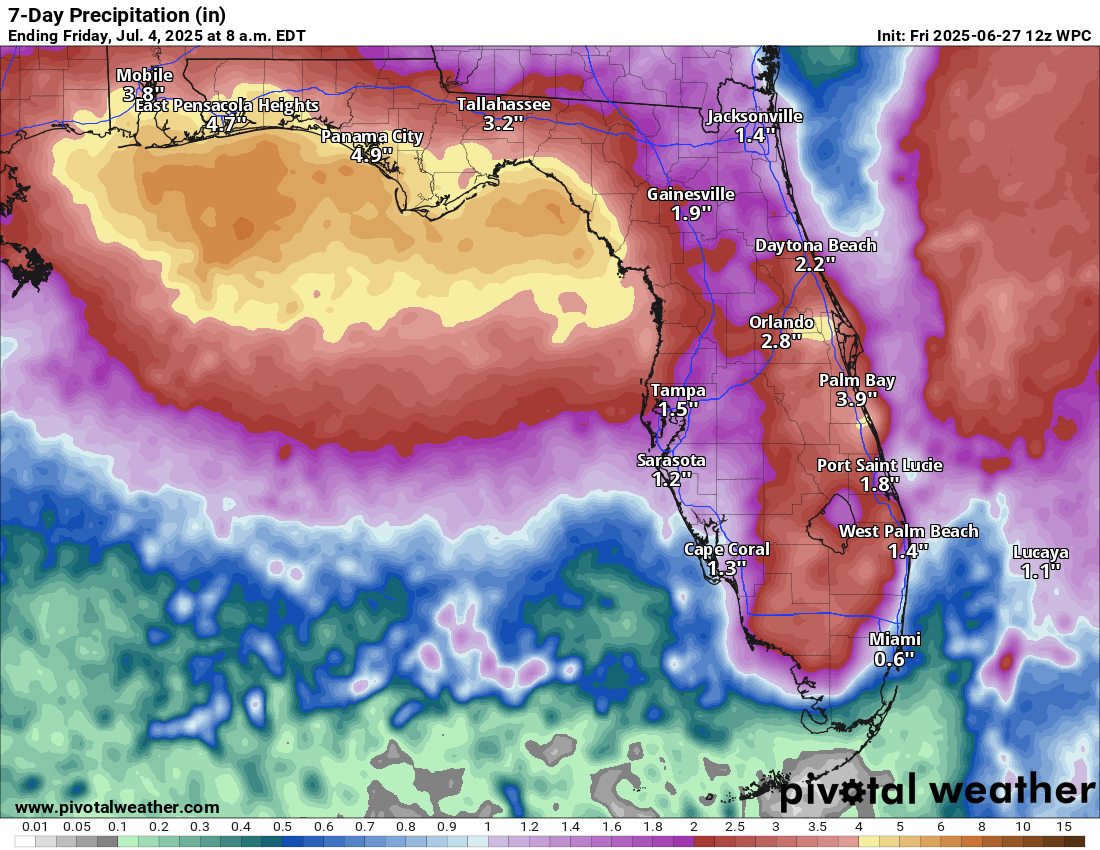
The heavy rain risk later next week is noteworthy with several inches of rain possible in Florida, especially along the coast between Pensacola and Tampa. This could lead to some eventual flash flooding issues there.
Rainfall forecast for Florida through July 4th morning. (Pivotal Weather)
Meanwhile, let me tell you what I know and what I think this means. I’ll caveat this by saying that this administration has a well-documented habit of making rash decisions, triggering outrage, and then either pulling back the decision or changing it in some way to make it more palatable overall. So what I write here may be outdated literally 5 minutes from now. If they’re trying to build massive frustration, chaos, and increase unpredictability, they’re being quite successful. That said, since this situation seems to start at DoD, I don’t believe we’re going to have a positive resolution.
What is this satellite data?
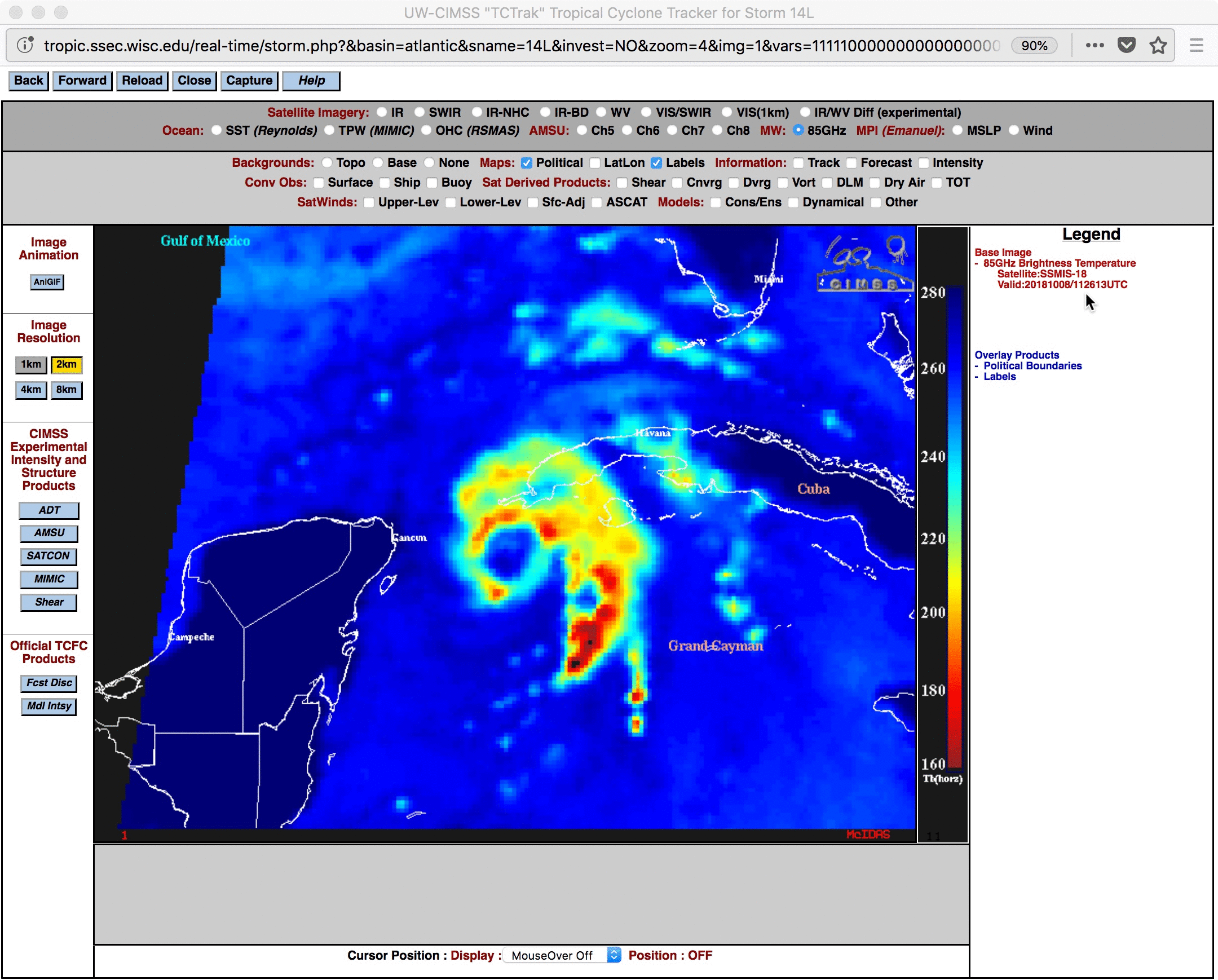
The Department of Defense has 3 satellites in space that provide a bunch of weather monitoring and space weather data. One of the most important is the Special Sensor Microwave Imager Sounder (SSMIS). The SSMIS data is a key component in hurricane forecasting, as it allows forecasters to observe the features of a tropical system that cannot be adequately viewed on regular weather satellites. Take for example the below image I am borrowing from the University of Wisconsin.
Tropical Storm Michael (2018) comparison using regular weather satellite and the microwave SSMIS data. (University of Wisconsin)
Notice how on traditional weather satellite, Michael looks like a very active storm with numerous thunderstorms. But in the “bluer” image, you can actually see an eye forming underneath the thunderstorms. Michael eventually hit the Florida Panhandle as a category 5 hurricane. This is a nice precursor for a meteorologist to get a view on to help inform forecasting or intensity estimates of a storm. In fact, it’s arguably critical information to have to help predict or identify that a storm is rapidly intensifying. It also helps us peg down the center of a storm when you don’t have aircraft out observing it. We sometimes take hurricane hunters for granted, as they’re not in every single storm. It’s tools like this that have been developed that fill the gap.
What is happening?
The DoD has announced that as of Monday this data will no longer be available to anyone.
But, surely the National Hurricane Center will retain access, right?
As far as I am aware and what is being reported in the media, the NHC does not have an exemption from this order. And this data will no longer be available for anyone outside of DoD. That may or may not be the case, but no one has said anything to this point to assume so one way or another.
What will losing this mean for forecasts?
Right out of the gate, if we have this data missing, you can expect a few things.
First, particularly for storms that are early in their development cycle, you will have a less accurate position of the center of the storm. Why does this matter? Because that’s what gets fed into every single model we use to forecast.
Second, when a storm is rapidly intensifying, we may get a delayed reaction. In other words, it may be 3 or 4 more hours after it begins that we’re able to identify that it has begun. Why does this matter? First off, situational awareness of what’s happening. Delaying that is poor. But of more importance, again, you are feeding models this data. Garbage in, garbage out. If you input a less accurate picture of intensity, you’re more likely to get an inaccurate intensity *and* track forecast. Intensity impacts track.
Third, the ripple effect of all this means less accurate forecasts at scale: Poorer NHC forecasts, poorer model forecasts (including from the European, ICON, Canadian, etc. models), potentially less warning that a storm is coming at a level that requires evacuation decisions. That’s not an exaggeration either.
Can we replace it with other data?
There are other microwave sensors on other satellites outside of DoD that we can use to fill some gaps. However, as Lowry reported in the link above, the DoD sensors comprise half of all microwave sounding data. So basically, while there is still a lot of data available, you are taking one critical data set and slicing it in half. Basically, you’re setting hurricane forecasting backwards.
So why is the DoD doing this?
The official reasoning is security. No specifics have been given. There was no head’s up. They just pushed out the memo above, and here we are today. In Matt’s opinion, it would have been nice for them to include disseminating the data to NOAA still. But perhaps whatever security issue is occurring affects that too. Who knows, but it would be nice to know from a public awareness and safety standpoint why we’re willfully degrading hurricane forecasting.
Bottom line: The government has decided that a key tool utilized by government and private sector meteorologists and researchers to track the intensity and position of tropical systems is going away on Monday with no actual reasoning and no replacement identified. While the public affairs folks will say they still have robust and significant data available to NOAA and the public, the reality is that one of the most important tools in the arsenal will no longer be there every time we need it to be.
In brief: The Atlantic should be calm over the next week, though there’s a low chance of something to watch next weekend off the East Coast. The Pacific gets active again this weekend. Heat winds down and by next week a less noteworthy pattern dominates the U.S.
Atlantic dust but a little something next weekend
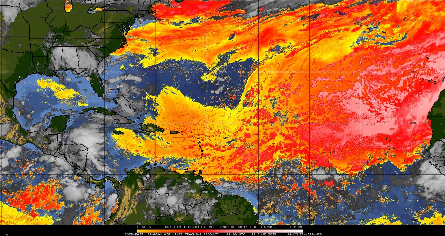
On the Atlantic side of the coin, things continue quiet for the next 7 days. The entire central and eastern Atlantic is basically smothered in Saharan dust right now.
Saharan dust (yellow, orange, red, pink) covered the majority of the Atlantic basin. (University of Wisconsin CIMSS)
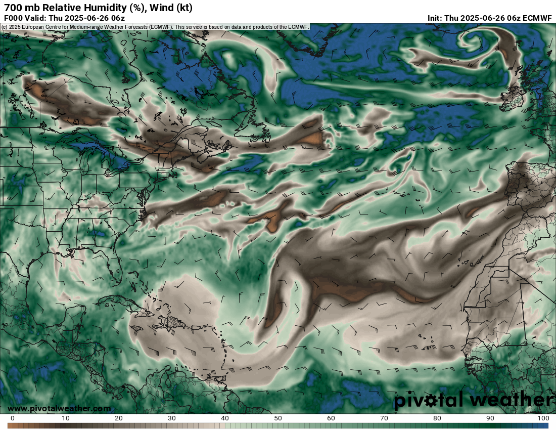
The dust indicates the presence of dry air, which is easily seen when you look up about 10,000 feet in the atmosphere at the relative humidity across the Atlantic.
Dry air (brown) covers most of the basin concurrent with the Saharan dust. (Pivotal Weather)
The only hint of anything right now for the next 7 to 10 days will be off the Southeast coast late next week or weekend. Models have been fairly consistently showing the potential for a disturbance to emerge there and likely scoot out to sea. Model support for this is across the board from traditional to AI models. We’ll keep an eye on that, but at this time, there’s no support for anything of concern to the Florida, Georgia, or Carolina coasts.
Pacific back in action soon
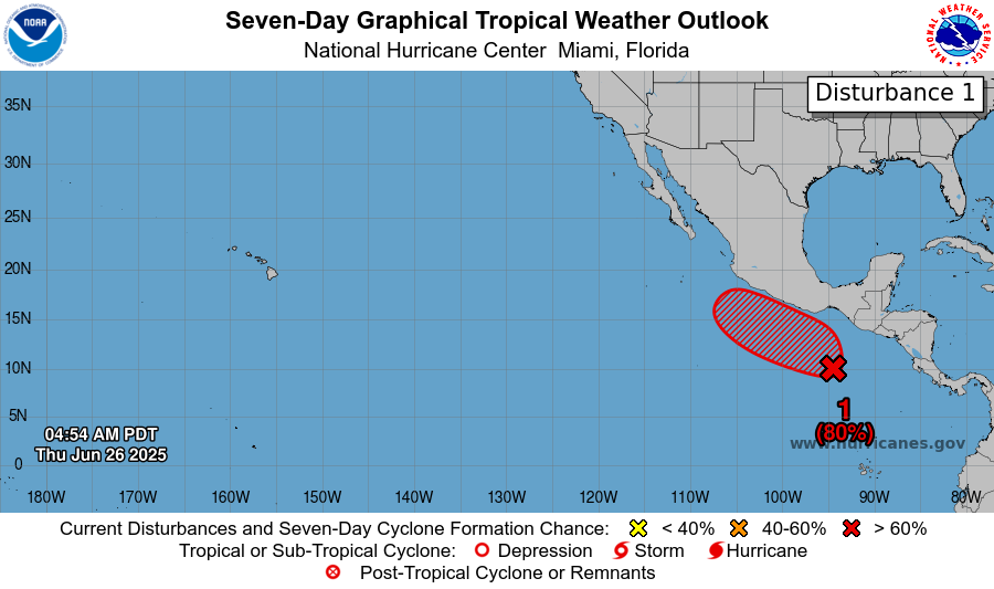
Look for the Pacific to wake up from its short late June slumber soon. A disturbance off the coast of Mexico will have about an 80 percent chance of developing by this weekend.
A disturbance off the coast will be likely to develop by this weekend. (NOAA NHC)
While the general model consensus currently keeps this system just off the coast of Mexico, some of the more reliable guidance does keep this thing awfully close to the coast, so it’s possible that impacts, at least indirectly, will be felt from about Oaxaca north to Baja as this lifts up the coast. It seems unlikely that this would be a major storm due to proximity to land, but something fairly well organized could emerge from this for a time. Worth continuing to monitor for those in Mexico.
Evolution of the heat wave from here
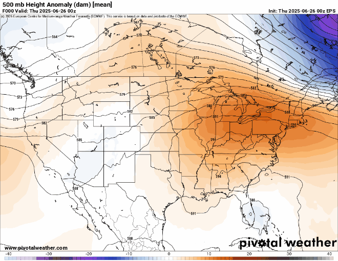
The Eastern U.S. heat wave is beginning to slow down now. However, it won’t completely disappear. Look for a gradual wind down in temperatures over the next several days, especially in the Midwest (though Friday looks quite cool in the East). Severe weather risks will continue around the periphery of things, including the northern Plains and Upper Midwest. But as you can see from the map below, it’s not until next week that we see some troughing begin to develop in the East, which should deliver some cooler weather.
The upper pattern supports a gradual wind down of warm weather in the East, with an emerging cooler pattern later next week. (Pivotal Weather)
Meanwhile, you can see a big ridge pop up in the Pacific Northwest or western Canada. Next Tuesday looks especially hot with mid-90s in Spokane, 80s in Seattle, and near 100 in Boise. But at least for a moment, by the time we get to the middle of next week, the overall pattern across the country looks fairly standard with nothing too spicy.
In brief: Tropical Storm Andrea formed yesterday — and dissipated yesterday. Heat records were shattered on Tuesday in the East, but the heat will slowly fade away now. Flooding risks continue in New Mexico, and more rain is likely on the way for the Southwest next week.
Atlantic
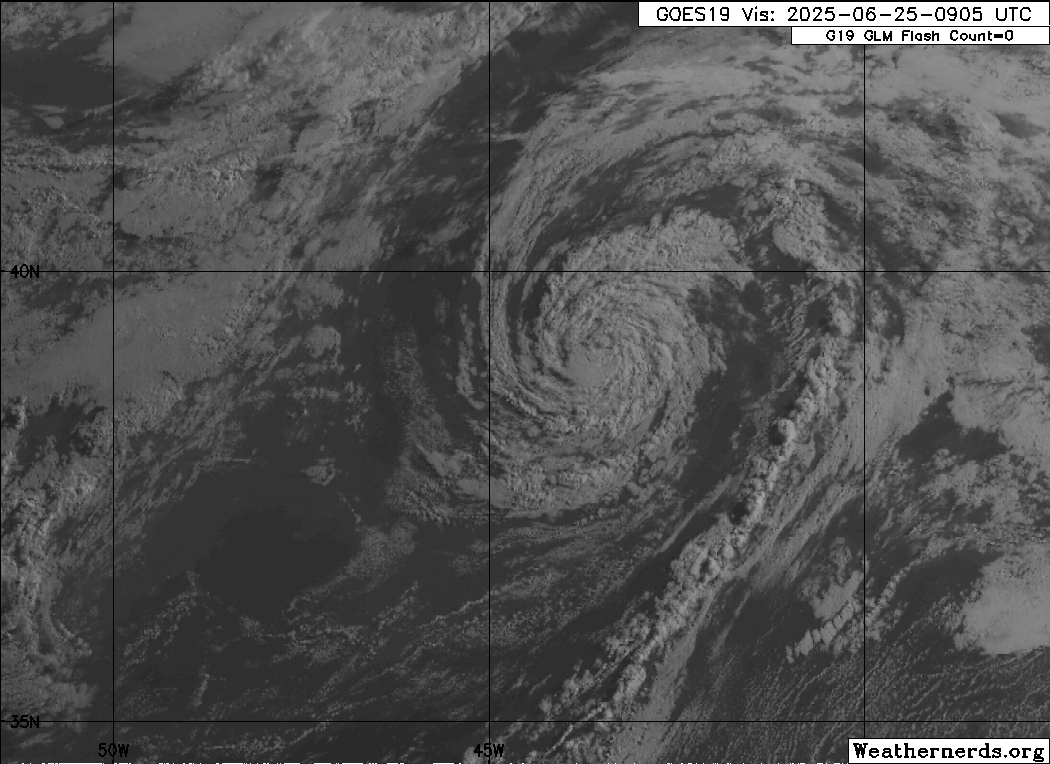
This morning, we start with a tribute to Tropical Storm Andrea. It formed yesterday morning around 10 AM Central Time. It left us a full 12 hours later. It fought a courageous battle but was ultimately no match colder water temperatures, drier air, and wind shear. Andrea set an example that all other tropical systems should seek to follow between now and November. For that, we are grateful.
All that remains of Tropical Storm Andrea is this swirl and the memories. (Weathernerds.org)
In all seriousness, with Andrea coming and going, the Atlantic looks to remain quiet for the next week or more. The Pacific will awaken again this weekend or so.
Heat records obliterated
Let’s just talk for a moment about the heat yesterday in the East. On Monday, we saw outrageous dewpoints. Yesterday was about temperatures. State temperature records for June were tied or broken in Vermont, Maine, New Hampshire, Massachusetts, Rhode Island, Connecticut, and Maryland.
🌡️7 STATES BREAKING A FULL STATE MONTHLY RECORDon the same day is something we saw very few times in the past 150 years in USAToday is ONE OF THOSEA small list of the several hundreds June records broken which includes NYC,Boston,Newark,Baltimore,Providence etc..👇
For Boston, 102° was their hottest June day on record and 4th hottest day overall on record. Providence saw their hottest June day on record and 6th hottest overall day on record. It wasn’t just the mayoral primary heating up in New York City. Central Park’s 99 degrees was a record for the date, but it fell short of June’s temperature record of 101°. LaGuardia’s 101° ties the June record. 102° at JFK Airport was tied for 3rd hottest all-time and set a new June record. The 103° in Newark, NJ ties for 12th hottest on record and ties the all-time June record. Shout out to my hometown of Atlantic City, tying for 6th hottest day on record at 102°. The hottest day on record was in June of 1969. Philly hit 101°, while Baltimore and DC were comparatively cooler at 98° and 99° respectively.
The heat will begin to ebb now. Another round of multiple temperature records are possible in the Northeast Corridor again today, but they will fall short of yesterday in most cases.
Another spate of records should be broken or tied today, but in most cases they’ll fall a good deal short of yesterday’s values. (NOAA)
Notice how nationally (at the top of the image above) the number of records threatened drops off dramatically after today. The number of nighttime low warm records is pretty wild, but that’s worthy of another post on another day.
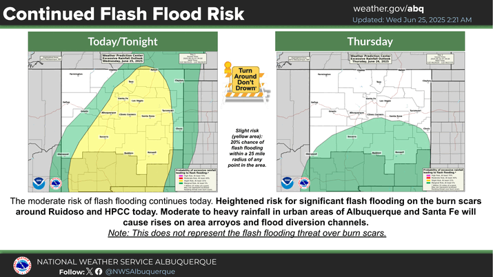
Desert Southwest soaking
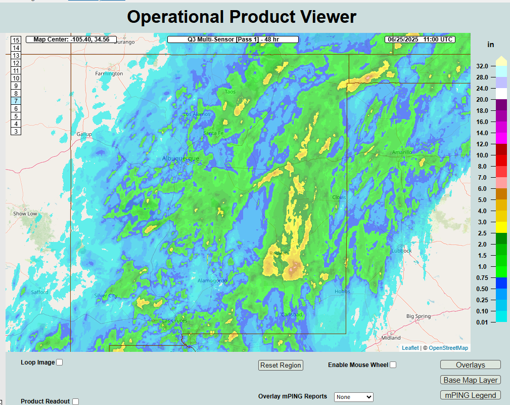
Parts of New Mexico have received 3 to 6 inches of rain in the last 24 to 48 hours, triggering multiple flash flood warnings across the state on Tuesday.
Significant rainfall as high as 3 to 6 inches has fallen in the last 24 to 48 hours across parts of New Mexico. (NOAA NSSL)
Additional showers and thunderstorms are likely today but hopefully in a more isolated fashion. Several more inches of rain may fall in parts of the state however before all is said and done.
(NWS Albuquerque)
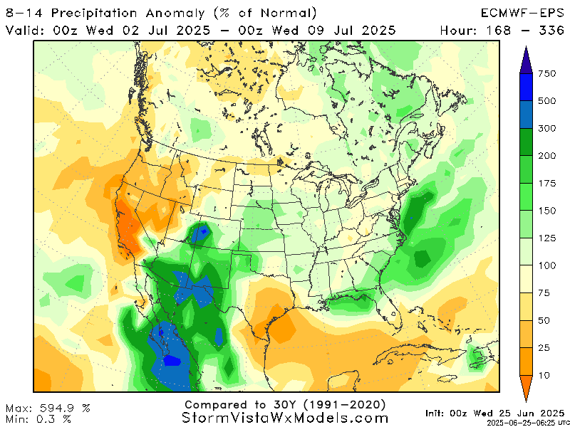
Looking farther out in time, it looks like monsoon season is really going to begin to flex in the Southwest next week, with heavy rain possible again in New Mexico but also perhaps parts of Arizona and West Texas.
Rainfall as much as 200 to 300 percent of normal is possible next week and weekend across the Desert Southwest as monsoon season ramps up. (StormVista Weather Models)
Keep in mind that 300 percent of normal in the Desert Southwest equates to about an inch or so of rain. So from that standpoint, it’s not a ton. That being said, some operational modeling does hint at higher totals than this. This far out, you’re just looking for a signal, and that signal is clearly pointing to an uptick in rainfall there.
Where does heat go next?
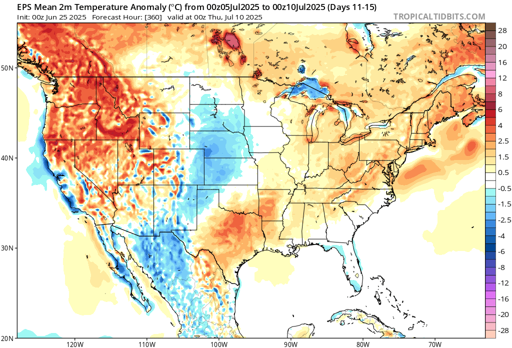
Heat will fade in the East, as we noted above. So where does it go next? Well over the next week or so, any heat should be transient in nature, meaning it’ll come and go in spots. Some places that may see an uptick in stronger heat include the Upper Midwest (Minneapolis could push into the 90s this weekend). The interior Northwest could see a burst of heat next week, with Spokane pushing the mid-90s by Monday or Tuesday. Thereafter, it may be Texas that sees the heat too.
Day 11 to 15 temperature anomalies show Texas heating up later next week with 100s possible in Dallas and upper-90s in Houston. (Tropical Tidbits)
Summer doing summer things after an extreme late June for parts of the country.