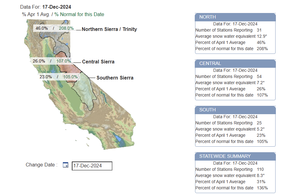
For meteorologists, winter technically starts at the beginning of December, not at the solstice which is coming up here shortly. But winter weather can happen all throughout fall too, and so far this season there’s been a bit of it around the country. We’ve seen some decent snows at times in the Sierra of California, where the snowpack is running around 100 to 200 percent of normal for the date.
California snowpack is in good shape for this time of year. (California DWR)
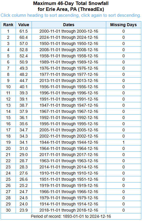
The lake effect snow belts have been crushed this year at times. Erie, PA for example is having their second snowiest start to the season since recordkeeping began there in the late 1800s.
Erie, PA is off to their second snowiest start to a winter on record. (NOAA)
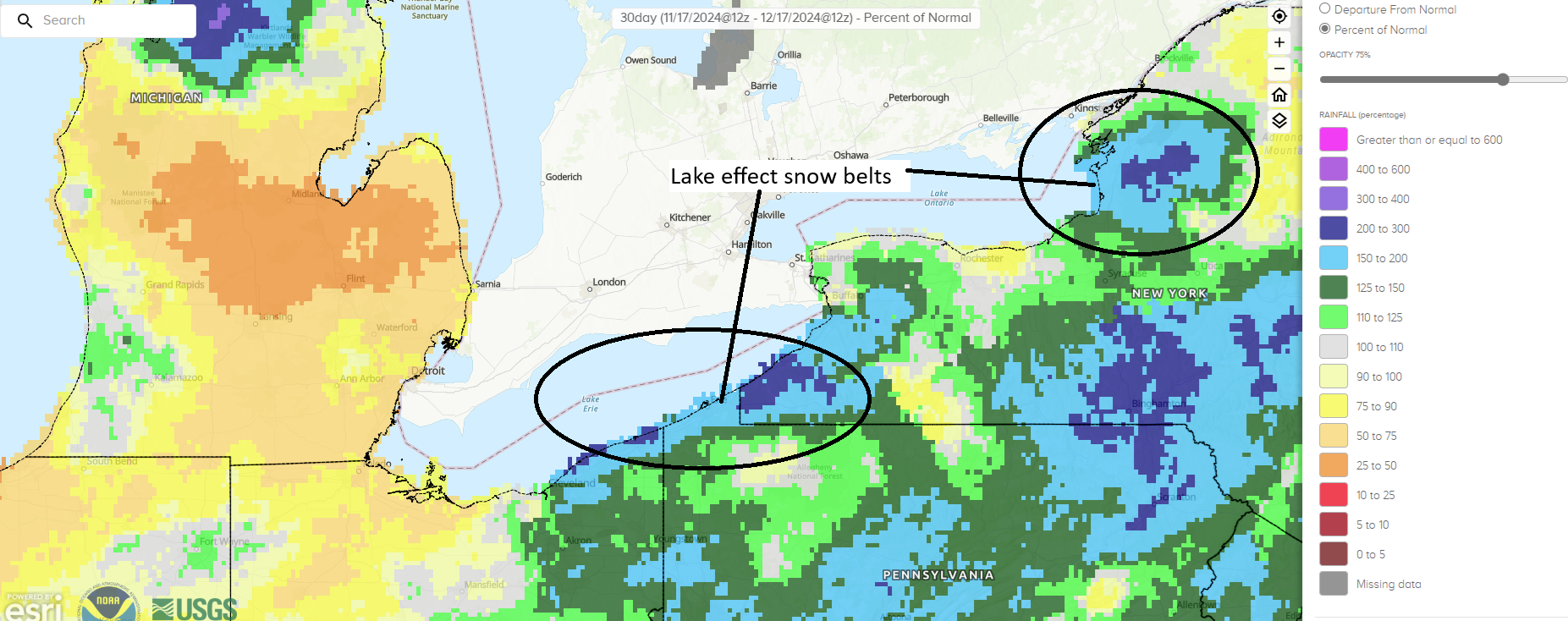
Many people think of Buffalo being the lake effect magnet, and it is at times, but the wind direction has definitely favored some of the Pennsylvania and southwest New York snowbelts. Precip is running about 150 to 200 percent of normal over the last 30 days in Erie versus 75 to 100 percent of normal in Buffalo. You can also see a lake effect snow signal off Lake Ontario too toward Watertown and the notorious Tug Hill Plateau.
The lake effect snow belts have seen significant precipitation over the last 30 days, impacting the area between Cleveland and Buffalo and east of Lake Ontario quite significantly. (NOAA)
There’s been some cold at times, certainly in the northern Plains and Midwest and Northeast. But also the Intermountain West has been chilly at times. Not their coldest start to a winter by any means, but firmly in the middle of the pack or below average.
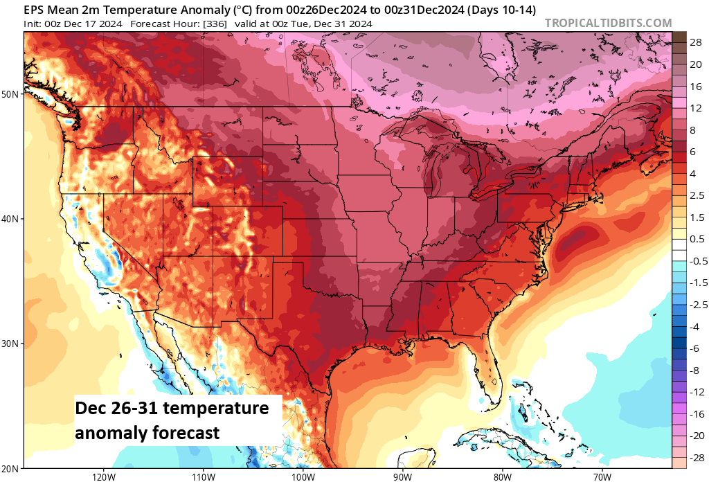
And we’ve got another blast of cold incoming here over the end of the week and parts of the weekend in the eastern two-thirds of the country, including a modest snow event tomorrow through Friday for parts of the Plains, Upper Midwest and Lakes. More mountain snows are likely out West also. But this pattern is going to change in a very big way after the weekend. A ridge of high pressure in the upper atmosphere that’s expected to shift about two standard deviations from the mean, with even a 20 to 30 percent chance of a 99th percentile event. In other words, the ridge is going to be strong for December. As you might expect, that’s likely to lead to abnormal warmth.
The December 26 through 31 temperature forecast is ugly if you like cold and snow. (Tropical Tidbits)
In fact, it’s not just likely to be warm, the confidence level in a warm forecast is about as good as you’ll ever see at this lead time.
Today's CPC 8-14 Day Outlook is the most above normal (reddest) one they have issued (2008-present) for the Lower 48. The average location in the Lower 48 has a 75.9% chance of being above normal, a 19.9% chance of being near normal, and a 4.2% chance of being below normal for the Dec 24-30 period.🔥
CPC forecasts are not technically intensity forecasts; they’re confidence in above or below normal forecasts. That said, one could probably interpret their map shown by Brian above and the 5 day average for the 26th through 31st above it similarly. Warmer than normal and potentially much warmer than normal.
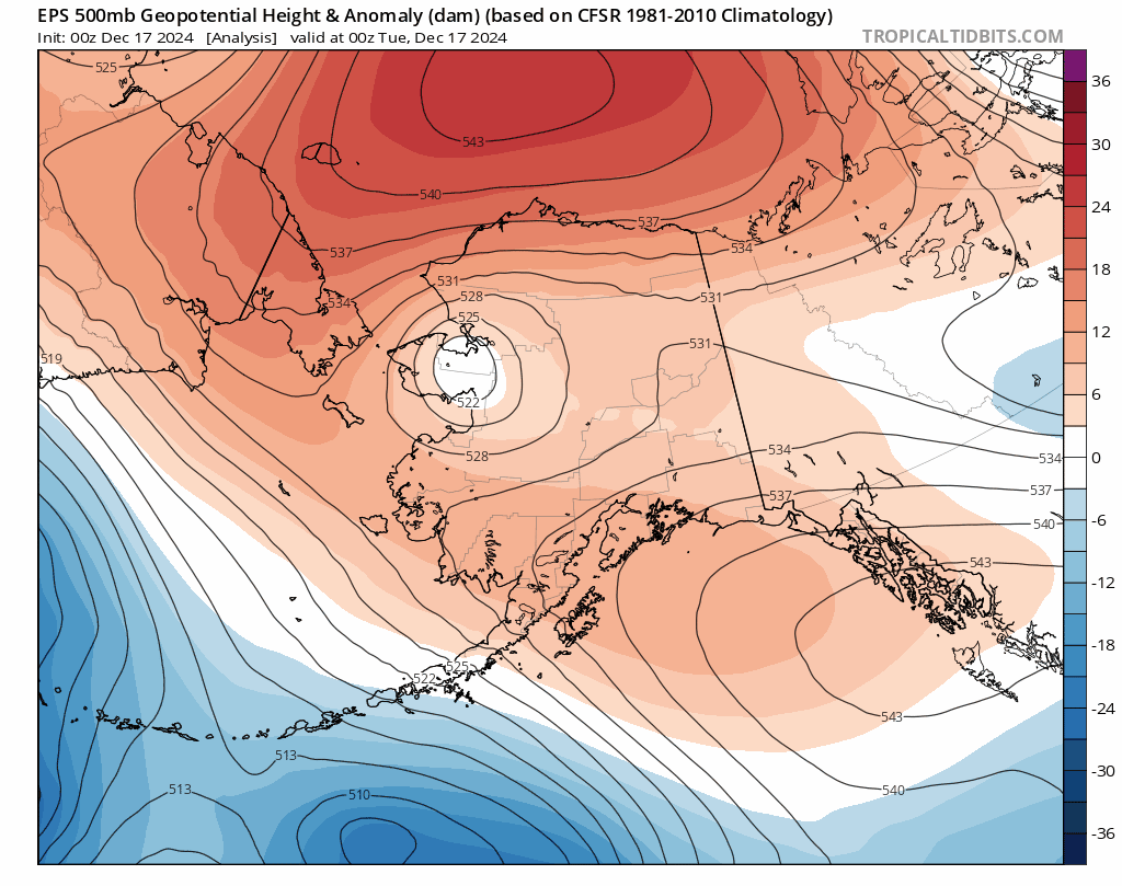
So what’s the deal? Is winter over? No, it’s December 17th. Winter is not over. However, we need to see some changes to dislodge this developing pattern next week. It would be very helpful to see the pattern over Alaska change. The animation below shows forecast height anomalies 20,000 feet up over the next 2 weeks or so. Above normal heights will often correlate to colder weather being dislodged from Alaska and northwest Canada and deposited south and east into the continental U.S. Indeed, we see above normal heights in the near-term, followed by a swift transition to deep blue, below normal heights next week. Good news for Alaskans who like cold weather. By the end of the model run we maybe see some changes over Alaska in terms of rising heights. This could help lead to downstream changes over the Lower 48, but whether that happens or not just as we cross into 2025 remains to be seen.
A pattern over Alaska hospitable to Lower 48 cold transitions to one that is decidedly hostile to it next week before some relaxation of the pattern late. (Tropical Tidbits)
The bottom line: It’s more likely to be a warm Christmas than a white one in many places. Next week looks ugly for winter lovers across the Lower 48. There may be some changes by about New Years, but exactly how fast any transition back colder occurs remains very much TBD at this time.
Hurricane season ends today, officially, although it’s been quiet for the last 10 days or so. Offseason storms have occurred. The last wintertime tropical system was an unnamed storm in January of 2023 off the coast of New England. Hurricane Alex occurred back in January 2016 out in the middle of the Atlantic. An unnamed storm formed near the Azores in December of 2013. The 2007 Atlantic season continued into December with Tropical Storm Olga, which racked up $45 million in damage in the Caribbean.
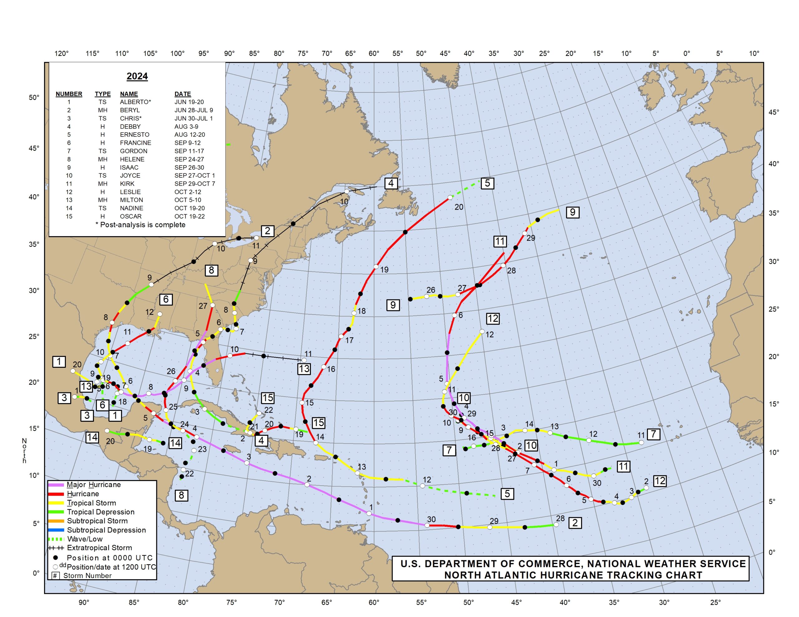
An analysis of the 2024 Atlantic hurricane season through Hurricane Oscar in October. (NOAA NHC)
The 2024 Atlantic season will likely be remembered for the Appalachian flood disaster due to Hurricane Helene, as well as the relatively quick follow through in Florida from Hurricane Milton. Helene will almost certainly be retired in the post-season, the first “H” storm to get that treatment since 2017’s Hurricane Harvey. I suspect Milton will also be retired, which would make it the first “M” storm since Hurricane Michael in 2019 to be retired from the list. The “B” storms are particularly tough to retire, given that they’re usually weaker and earlier in the season. The last “B” storm to be retired was 33 years ago, Hurricane Bob (which this author remembers from being sideswiped in New Jersey as a kid). Beryl will also almost certainly be retired, less so for what happened in Houston and more for what it did to some of the Caribbean islands as a category 5 storm.
The “A” storms are a bit easier to retire, with notable intense storms like Alicia, Allen, Andrew, Anita, and Audrey on the list. Flood events like Allison and Agnes have also been retired.
Storm names are generally retired because they were especially memorable or catastrophic in terms of property damage or loss of life. It’s part of why naming works for hurricanes; if it was an especially bad storm, that name will never be heard again except in relation to that specific storm.
The total damage from this season is likely to top $100 to 150 billion in damage based on various reliable estimates. There’s a much deeper story to be told here. Between various disasters and inflation in recent years, the cost of insurance has risen dramatically. This year likely did not help those problems. Folks like Steve Bowen below, as well as Kelly Hereid and Susan Crawford’s “Moving Day” are very good resources to follow this ongoing story.
Most people tend to focus on the hazard portion of weather / climate risk. Which is important.The next step is connecting the dots so everyone understands that this is a real and growing economic / pocketbook risk.It could lead to a future financial crisis.www.redfin.com/news/florida…
Back in May, I described the upcoming hurricane season as likely to be an “arduous slog.” It ended up that way in the end, sort of, but a bizarrely silent August threw a massive wrench in forecast expectations this year. NOAA’s official hurricane outlook called for the following:
An 85 percent chance of an above normal season (verified)
17 to 25 named storms (18 storms, just verified)
8 to 13 hurricanes (11, verified)
4 to 7 major hurricanes (5, verified)
Accumulated cyclone energy (ACE) 150 to 245% of the median (About 120-125% of the 30 year average, fell somewhat short)
So overall this was a mixed bag of a seasonal forecast. There were some good calls and some overdone calls. In general, NOAA has actually had a bit of an under-forecast bias, with 4 of the last 5 years verifying above their forecast range.
2023: Forecast 14/7/3 and verified with 20/7/3
2022: Forecast 18/8/5 and verified with 14/8/2
2021: Forecast 17/8/4 and verified with 21/7/4
2020: Forecast 16/8/5 and verified 30/14/7
2019: Forecast 12/6/3 and verified 18/6/3
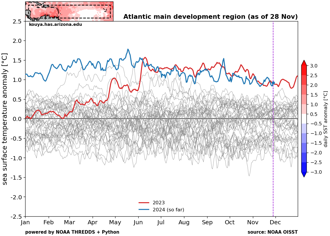
So, they met the target this year, though the ACE forecast was overdone. Much of this season’s absurdly high forecasts were driven by excessively warm water temperatures in the entire Atlantic basin, as well as the projected development of La Niña in the Pacific Ocean. The warm water temperatures held on all season.
Water temperature chart of the Atlantic main development region shows that 2024 (blue) was variably at record levels throughout the season. (University of Arizona)
Notably for 2025, we remain near record levels across the Atlantic, except in the Gulf which has mercifully fallen back to just “above normal” levels. So the water temperature forecasts were accurate.
So what about La Niña?
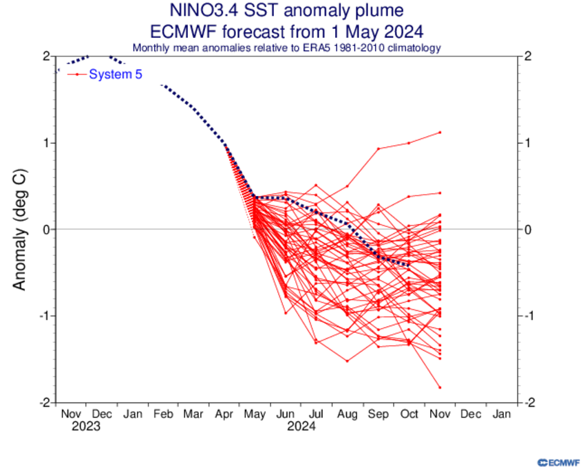
Though it was a little sluggish to get there, the May forecast (red lines) for La Niña essentially verified (dotted line) within the ensemble spread that was forecast in May. (ECMWF)
Well, this one is a bit more complicated, but the answer is that it partially verified, yes. The ensemble spread shown by the multiple members in red lines above did a nice job capturing the realistic spread in possible options. And through August, the La Niña seems to have struggled to develop. We seem to be getting there now, sort of, though we are not officially there yet and we may not officially get there. We’re basically ENSO neutral, leaning negative. So while the forecast technically verified within the plume, it did not get to La Niña, which probably had some impact on reducing potential storms.
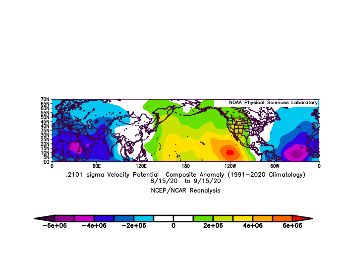
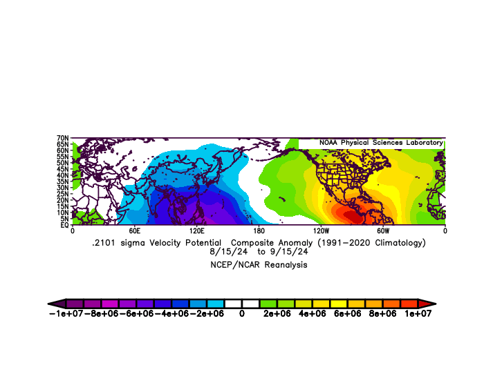
So what hurt August and why did this season “feel” like it really underachieved? Well, if we look at the variable of “velocity potential” as a proxy for “rising air,” where negative values (blue and purple) indicate more rising air than usual, we can see an interesting comparison to an active stretch like August 15 through September 15, 2020, which produced some hefty storms. Use the slider to see the differences.
A comparison of velocity potential between August 15 and September 15 in 2024 (less active) and 2020 (more active). (NOAA)
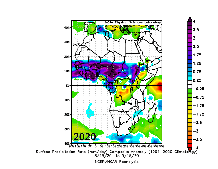
Both seasons featured generally significant rising air over Africa and/or the Indian Ocean, much like you would want to see in an active stretch. In 2020, however there was significant rising air over the Atlantic as well, whereas in 2024 we saw significant sinking air present in the Gulf, Caribbean, and parts of the western Atlantic. Interestingly, if you look at the rate of precipitation this year, you see a major difference in *where* in Africa the above normal rainfall occurred.
Comparison of precipitation rate between August 15 and September 15 in 2020 and 2024, showing a marked shift north in where the heaviest rain fell in Africa. (NOAA)
There was a good deal of talk this year about how the Sahara and Sahel were experiencing significant rainfall, and indeed there was a massive greening in the Sahel this year. Does this entirely explain why the 2024 Atlantic hurricane season was a bit less frenetic than expected? No, but it does offer a possible partial explanation and avenues for research that can help with future hurricane season outlooks.
Overall, there is a lot to unpack about this season. From a damage standpoint it met expectations. From a statistical standpoint, it met some expectations and fell short in others. The goal with this post was not to really explain everything, but I was hoping to at least offer some insights as to how what was predicted actually verified and what else may have been at play.
From this point, our site will go quieter. We will be monitoring the weather and likely chime in during some intense storms. This week’s lake effect snow probably would have offered an opportunity, and maybe on Monday we’ll push something. That said, thanks for your support this hurricane season! Keep spreading the word. If you feel so inclined, since we don’t have a “tip jar” here yet, you can donate through Monday at Space City Weather, our parent site in Houston to support our work! Thanks as well to our sponsors this season. Their support helped offset basically all our server costs and offered a small incentive for us to post. We are open to ideas, partnerships, etc. for the 2025 season, so feel free to reach out if you’re interested through the contact link. Thanks again!
Major Thanksgiving Day/Friday storm possible in the Eastern U.S., with snow possible in the interior or Ontario.
Cold air mass follows into the weekend.
Surge of mid-winter cold follows next Sunday into the first week of December, primarily for the Midwest, Great Lakes, and Northeast.
With hurricane season now behind us, it’s time to talk about winter. And if you live in the eastern two-thirds of the country, you’re going to see a pretty impressive dose of it incoming after Thanksgiving.
Active weather to kick off the week
The weather map today shows a continued pattern allowing for moisture in the West with several feet of snow coming to the Sierra Nevada. A major warm up is going to occur in the South-Central U.S., while colder air exits the Northeast.
An active weather pattern will deliver heavy snow to California and a major warm up in Texas (Tropical Tidbits)
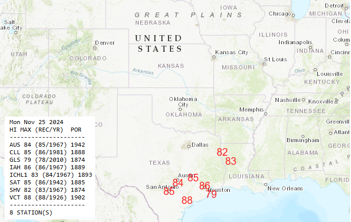
In fact, Monday will see record highs possible across southeastern Texas, including for Austin, San Antonio, and Houston, as well into Shreveport. Most of these records were set back in 1967, which would have been late in that year’s Thanksgiving weekend.
Record or near-record highs are forecast on Monday in Texas. (NOAA)
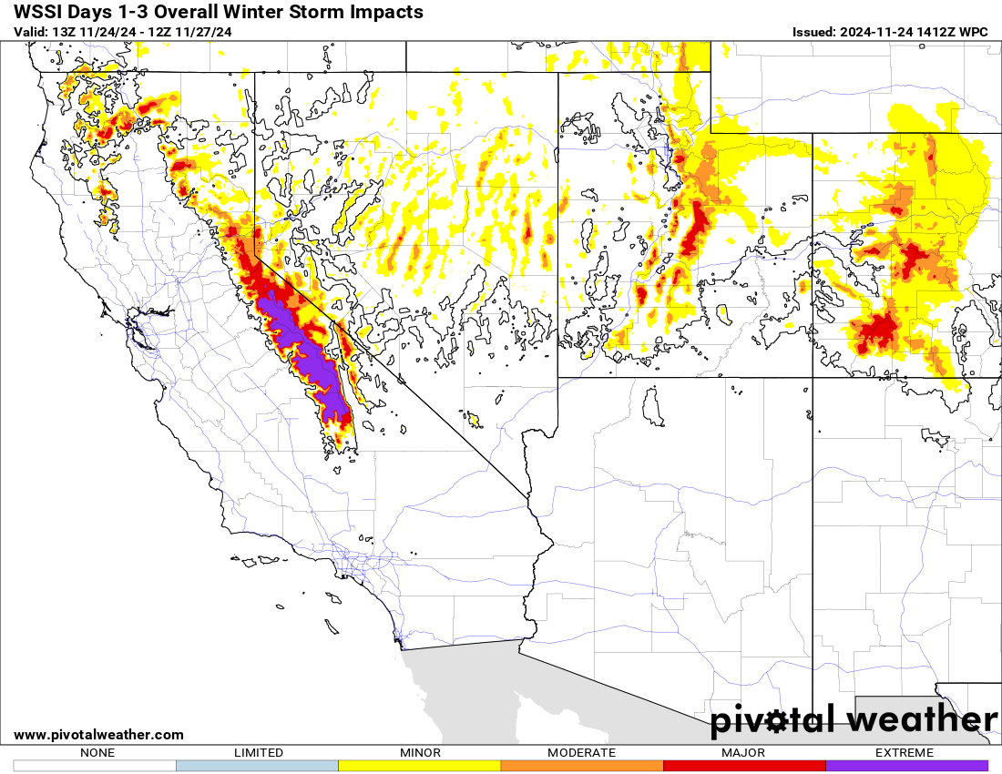
The snow forecast in California will be in feet, and “extreme” winter weather conditions are expected in the Sierra. As much as 7 feet of snow may fall at the highest elevations, giving California a big jump start on their water year snowpack.
Extreme impacts from snow are expected in the high Sierra. (Pivotal Weather)
First wave of cold
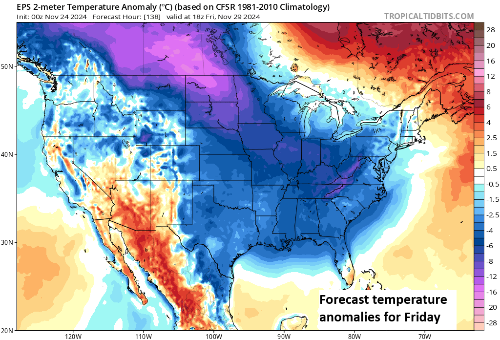
One cold front will sweep across the country Wednesday and Thursday, ushering in cooler temperatures on Thanksgiving Day and Black Friday.
Friday’s forecast temperature departures from normal, shows widespread colder than normal conditions everywhere except the Desert Southwest, Maine, and South Florida. (Tropical Tidbits)
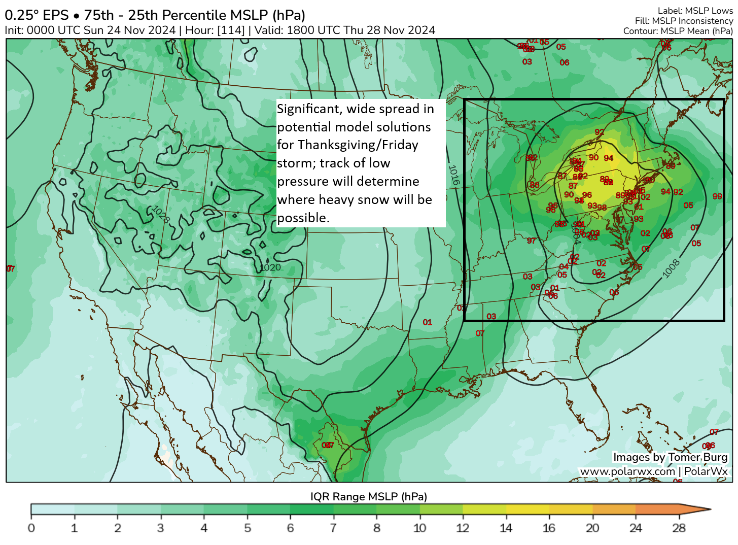
The first wave of cold is likely to come with a winter storm in the Eastern US, followed by lake effect snow as well. There is a great deal of uncertainty as to where heavier snow may fall on Thanksgiving Day and Friday, but portions of Ontario, interior northern New England, and Upstate New York would be firmly in the potential.
Extremely uncertain and wide-ranging forecast spread in possible positions of low pressure center on Thanksgiving Day and Friday leads to high uncertainty on snow placement. (Tomer Burg)
But for a 5-day out forecast, this is a really significant spread in possibilities. A track toward the Mid-Atlantic would keep the heavier snow firmly in place for portions of New York and perhaps Pennsylvania too. A track over Upstate New York would probably push the heavier snow back into Ontario. Either way, Thanksgiving Day travel in the Northeast and eastern Great Lakes will likely be impeded by this system. Start planning now.
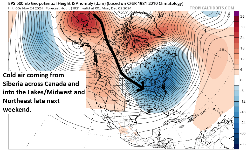
Second wave of cold; the real deal
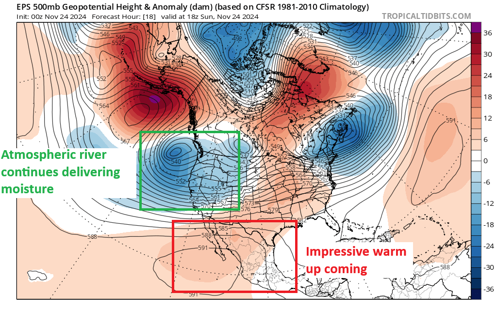
For those looking for winter air, you will get your wish after Friday or Saturday. A second surge of cold air, almost direct from Siberia is going to plunge into the Great Lakes and Midwest. This will usher in the coldest air since last winter, along with all the stuff that comes with it: Biting wind chills, potential for major lake effect snow, and at least a chance of additional snows here or there. For folks in Texas, it will turn colder but not nearly to the levels we’ve seen at times the last few winters. This cold is primarily directed into the Midwest and Northeast.
Coldest air since last winter plunges into the Midwest, Great Lakes, and Northeast late in the holiday weekend and during the week after. (Tropical Tidbits)
What does this translate to? We’re likely talking about highs in the 20s in Chicago and lows in the single digits or low teens. Similar temperatures would occur elsewhere in the Great Lakes and Midwest, so places like Cleveland, Detroit, Indy, and Minneapolis would all experience mid-winter type cold. Bottom line? Winter is coming.
Beyond that, December will probably see a bit of a warm-up after the first week, but it may take some time to dislodge the cold. Either way, November is going to go out with a bang across the Eastern U.S.
Hurricane season is unofficially over, as no activity is seen over the next 10 days, taking us through to about December.
2024 will end up as a “hyperactive” season but barely.
Meanwhile, the West is seeing a storm almost as strong as a major hurricane spinning offshore.
Significant, damaging wind is possible in the Seattle area tonight.
A prolonged atmospheric river in California and southern Oregon will produce over 10 inches of rain in spots, and a rare day 3 high risk (level 4/4) of flooding exists in northern California for Thursday.
2024 Atlantic hurricane season ends — we think
With the degeneration of Sara’s remnants yesterday, it would appear that we’re basically done with the 2024 Atlantic hurricane season.
Exhale. (NOAA/NHC)
Unfortunately, Tropical Storm Sara was deadly in Honduras while dumping upwards of 20″ or more of rainfall. As much as 1,000 mm (40 inches) was analyzed in northern, coastal Honduras. Though deadly, it appears that the number of fatalities will remain well under some other notable rainstorms of the past in Central America. Good warnings likely helped.
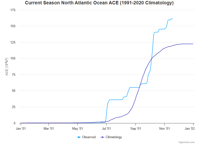
With that, the season seems to be over now, as we see nothing over the next 7 days, and the models are pretty quiet beyond that. So where will we finish? It appears 2024’s accumulated cyclone energy (ACE) will finish at the bottom of the list of hyperactive seasons. We had 18 storms, 11 hurricanes, and 5 major hurricanes. The 11 hurricanes tie for fifth most in a season.
This season’s accumulated cyclone energy (ACE) was driven by a late season surge, just pushing us to the edge of “hyperactive” status for the year, impressive but perhaps less so given the seasonal expectations. (Colorado State)
Did the season live up to the preseason hype? Probably not. But with over $190 billion in unofficial damages, it ranks near the top of the list of worst seasons on record. So you can find a metric that says this year was as bad as feared or was a total bust. The world is your oyster. But for parts of the Caribbean, Florida, and Appalachia, this season will be for the history books. And that’s really all that matters.
We can take a more in depth look at the season later. I want to transition us into post-season mode now at The Eyewall. We’re still experimenting with what works because we want to continue to grow our audience, but we also want to stay in our lane to an extent. Ultimately though, weather is our lane. And we should be chiming in when significant weather is a big story. And today, it’s a big story on the West Coast.
Western U.S. and Canada drenched and pummeled
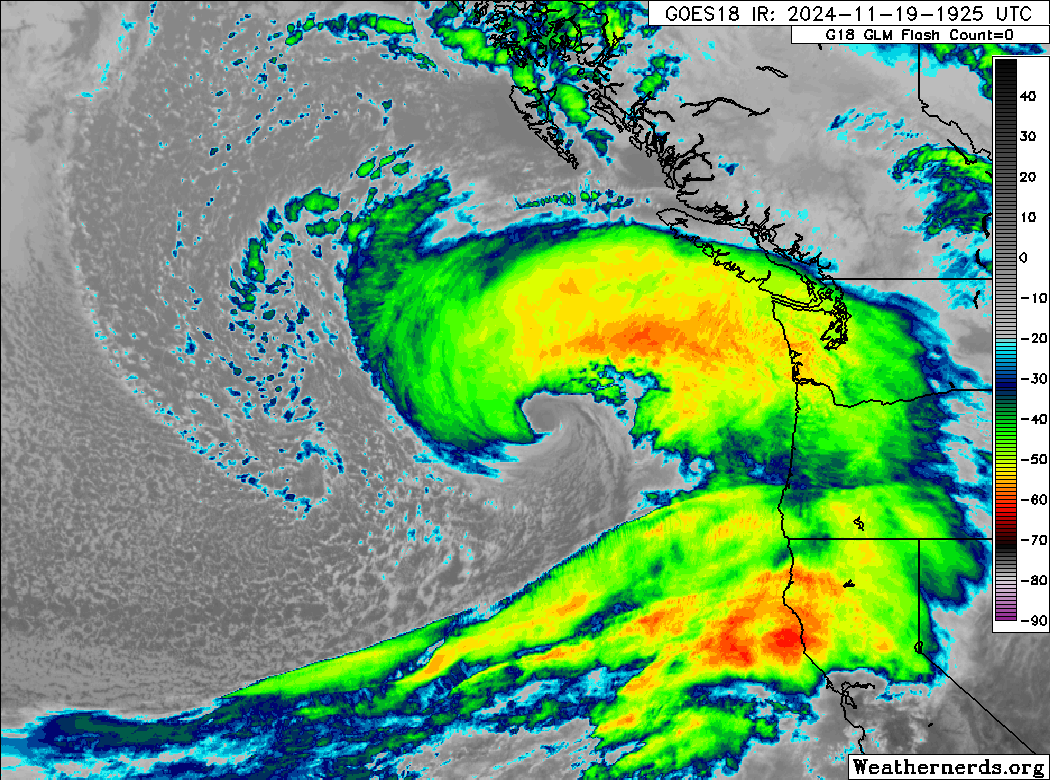
There are two major stories developing on the West Coast. The first is occurring as I type this. A massive storm is rapidly deepening off the Northwest coast.
A massive, potentially historic storm has developed off the coast of Washington and Oregon. (Weathernerds.org)
Yes, this is a bomb cyclone. That term gets tossed around often, and some people consider it hype. But it’s a legitimate meteorological term with a very specific definition. The lowest pressure of the storm must drop at least 24 millibars in 24 hours or less to attain “bomb cyclone” classification. While it may seem like bomb cyclones are rare, they really aren’t, happening multiple times a year on average near North America. What makes this particular storm stand out is the amplitude and rate of deepening that it is undergoing. Basically, the storm has dropped over 25 millibars just this afternoon, achieving “bomb” status incredibly quickly.
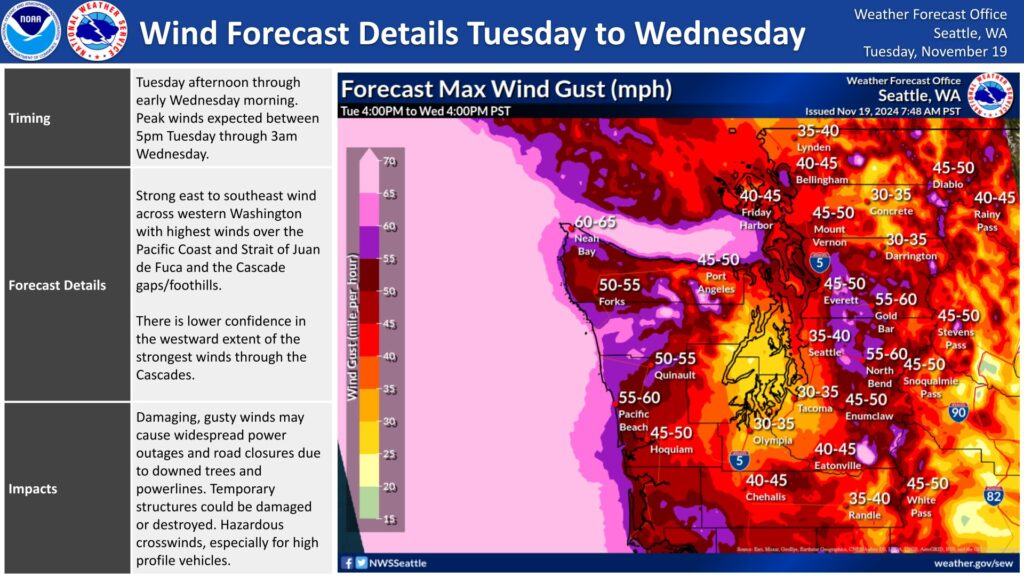
There will be multiple impacts associated with this storm, including a major downslope wind event east of Seattle tonight, where gusts in excess of 50 to 60 mph could occur in some of the heavily populated suburbs near the Cascade foothills. This will be worse than a typical wind event for this region, likely causing some localized damage and numerous power outages.
Very strong downslope winds in the Cascade foothills tonight could cause damage and knock out power on the eastern side of the Seattle metro. (NWS Seattle)
In addition, strong winds will occur at the coast, though thankfully the worst winds will remain well offshore due to the storm not making landfall. Heavy mountain snow and lower elevation rain will occur as well, and blizzard warnings are posted for the Cascades.
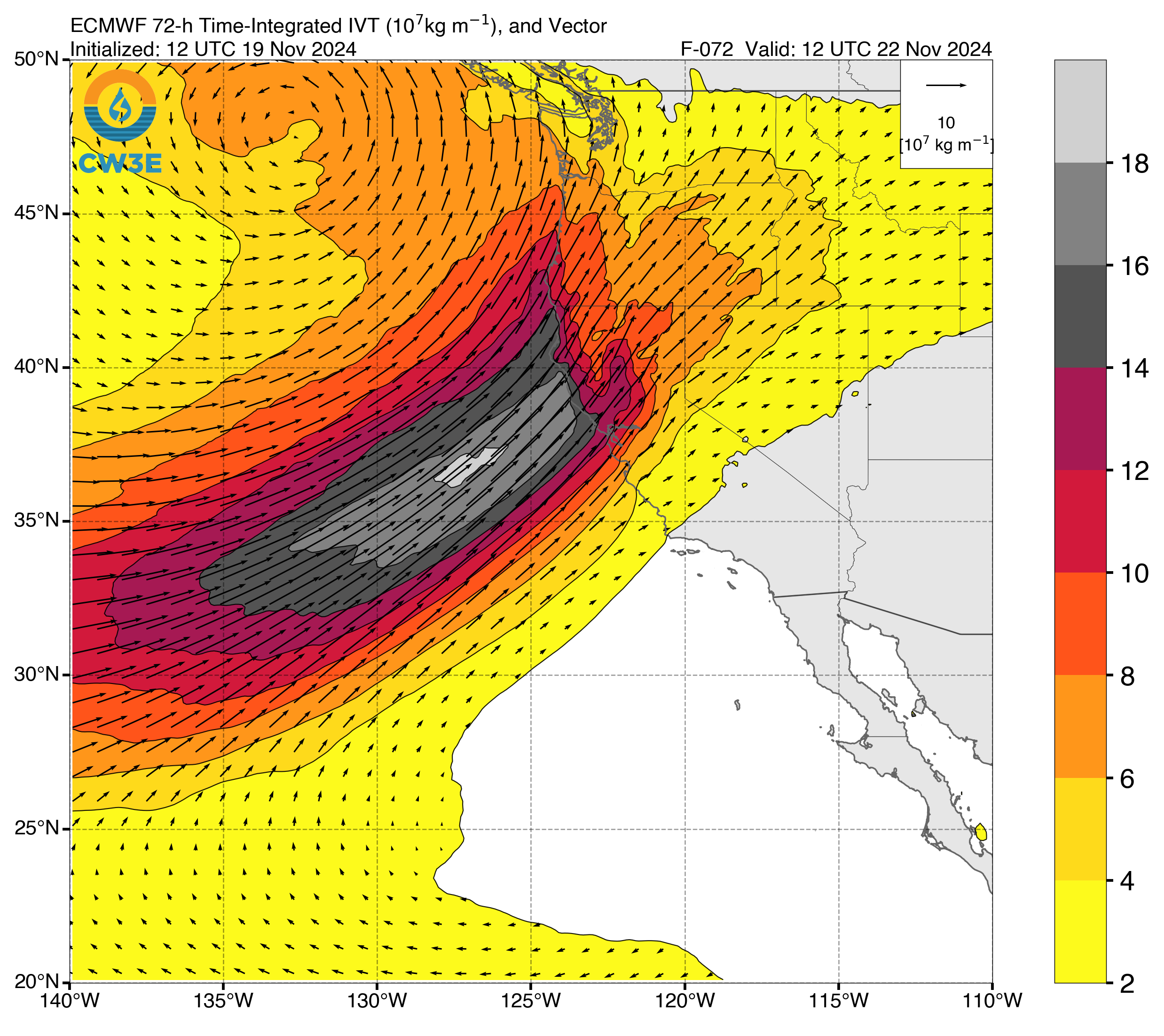
Meanwhile, a long duration atmospheric river event is going to take aim at California and southern Oregon in the coming several days, dumping copious amounts of rain and mountain snow, and some rain-on-snow potentially as well.
Over the next 3 days, the strongest portion of the atmospheric river will aim at northern California. (Scripps Center for Western Weather and Water Extremes)
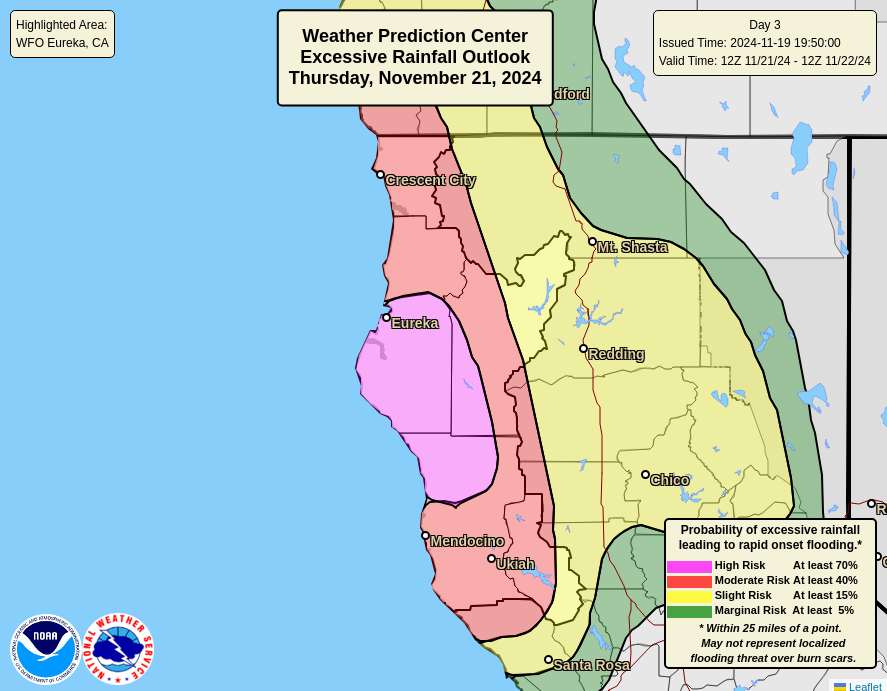
This will peak as a category 5 atmospheric river, which means significant impacts are likely, and the NWS Weather Prediction Center already issued a high risk of flooding (level 4/4) for northern California on Thursday, which I believe is the first time this has occurred for a non-tropical storm.
A high risk (level 4/4) is posted for northern California , north of Mendocino for Thursday for flooding rain. (NWS WPC)
High risks don’t seem to be as rare as they used to be, but obviously for a day 3, confidence has to be exceptionally high or the risk has to be exceptionally high. I think a confluence of factors is impacting that. In terms of rainfall over the next week, it’s going to get messy. Over 10 inches of rain should fall in some of the mountains in northern California. Snow will also occur, but as the atmosphere warms a bit, the snow levels will increase. So this could be a damaging event in addition to a possibly beneficial one. Extremes rule the day in California. More to come.