The National Weather Service in Paducah, KY did not mince words this afternoon in their briefing on the upcoming rainstorm across the Ohio Valley: “Significant and potentially historic rainfall will begin Wednesday afternoon, with numerous rounds of heavy rain continuing into the first half of the weekend, leading to potentially catastrophic flash flooding.”
I have a whole post eventually coming to my Substack page on words and how we use them. But suffice to say, whenever the NWS uses a word like “catastrophic,” it is an extremely deliberate decision that more than one person agrees to. In other words, they understand the weight of the word “catastrophic,” and after discussing it as a team, they agree to use that phrasing. Because they’re convicted of an outcome that they believe will indeed be possibly catastrophic.
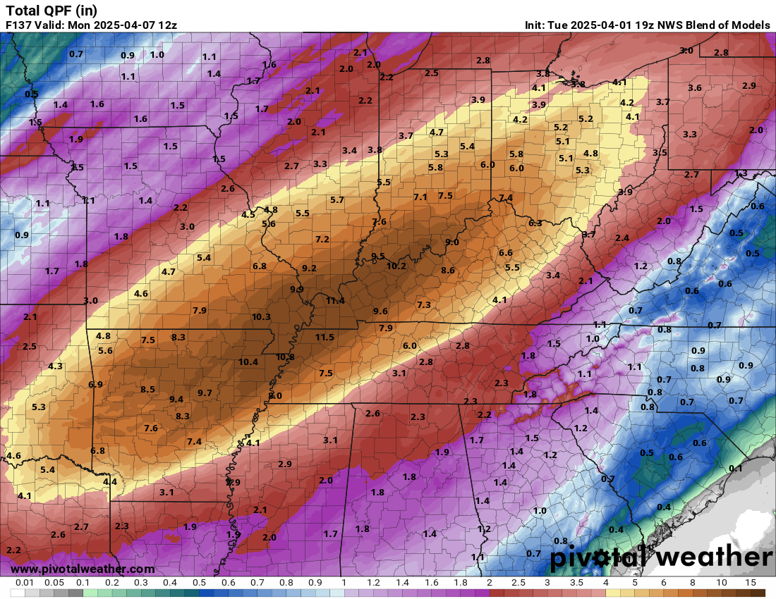
National Blend of Models (NBM) forecast rainfall through the weekend with pockets of 10″ or more between northeast Arkansas and southern Indiana. (Pivotal Weather)
And the model data today continues to provide ample additional support for a wide ranging, widespread, potentially historic and/or catastrophic outcome. Within their area forecast discussion, the technical briefing the forecasters at the NWS provide that essentially explains or justifies their decision-making, the Paducah office maintained that type of language. “We cannot overstate the extremity of the flooding danger with this event incoming and these historic forecast rainfall amounts.”
To the north, in Indianapolis, their forecast discussion stated it had the potential to be one of the most significant rain events in the last 15 years. “This has the potential to be near the top of the list for highest impact heavy rain/flooding events for central Indiana in the last 15 years.”
Same story in Memphis, where their office also warned of catastrophic flooding. “Catastrophic flooding remains possible in portions of the Mid-South Wednesday through Saturday as the previously discussed front stalls right along the I-40 corridor.”
I wanted to just post that so folks, especially new visitors, didn’t think that we’re just randomly going ballistic over something. No, this is objectively a very serious threat between Arkansas and Ohio that is going to make the national news. All we can do at this point is hope for the best.
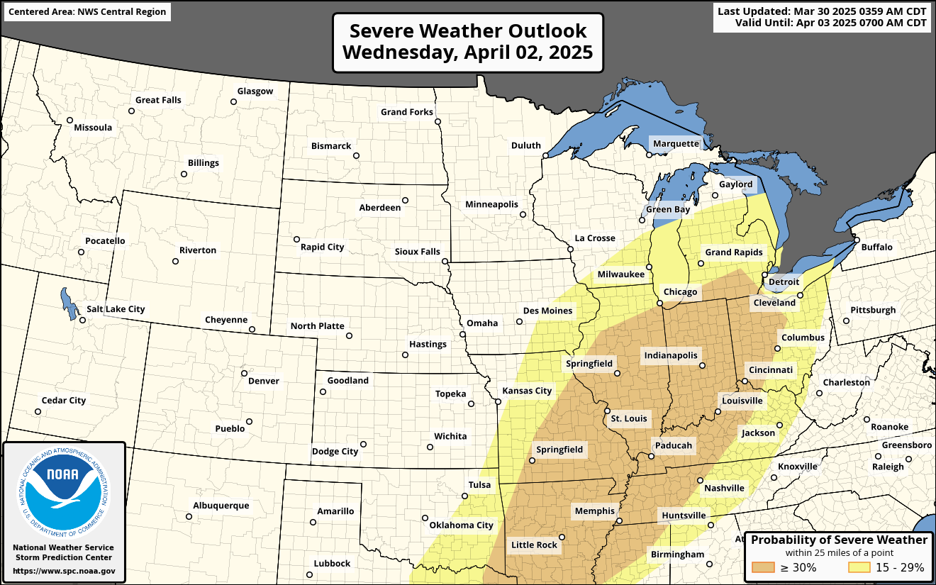
A very serious severe weather threat
There will also be severe thunderstorms at times, especially tomorrow (Wednesday) and Saturday I think.
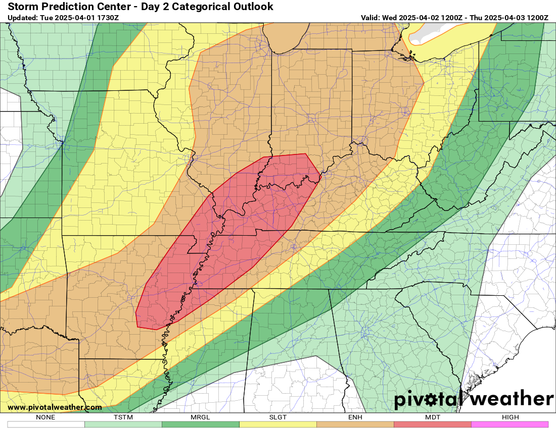
A moderate risk (4/5) is in effect for Wednesday between central Arkansas and southwest Indiana due to possible tornadoes, damaging winds, and large hail. (Pivotal Weather)
Being from Houston and having dealt with a 5-day rain event in 2017 by the name of Harvey, these types of events are long-duration tests of will. I’ve found that rather than trying to focus on every single element of the threat, it’s better to break it into manageable chunks. Today, that’s the overall rainfall threat (as laid out above), in addition to Wednesday’s severe threat. The moderate risk (4/5) was issued to cover all forms of severe weather (strong tornadoes, large hail, and damaging wind gusts), and all of them look potentially potent tomorrow. I will refer you to your local NWS office or some of the other fine weather blogs out there for more on the severe threat. There will be additional rounds of strong to severe storms across the Mid-South through Saturday, with perhaps Saturday itself being the second peak day of the event, in addition to peak concerns about flooding.
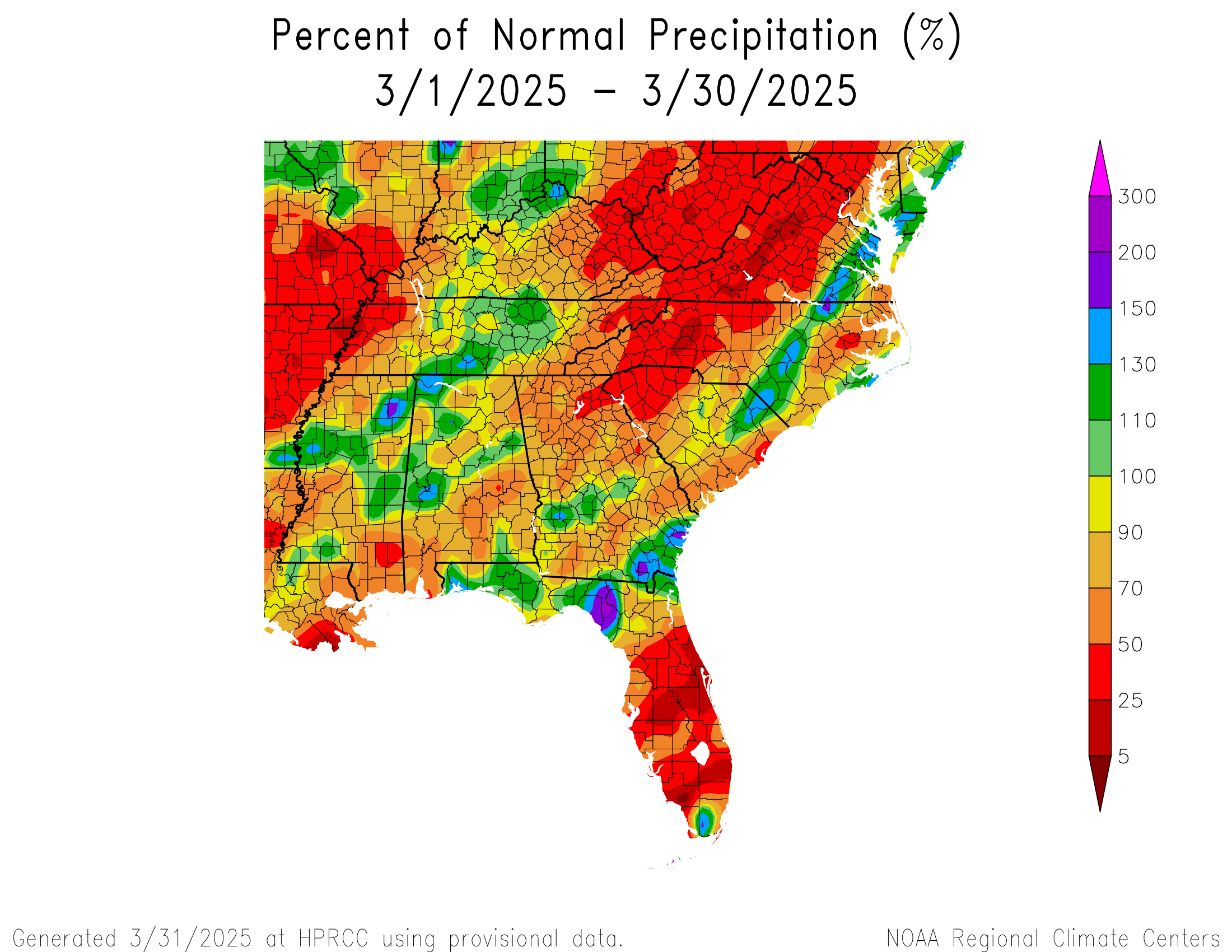
Percent of normal rainfall since March 1st. Red = drier than usual. (High Plains Regional Climate Center)
You can see that most of Kentucky has been slightly below average, with much drier conditions to the west into Arkansas and Missouri. Yesterday’s rainfall is missing from here, but in general, the theme has been at or slightly below average since early March.
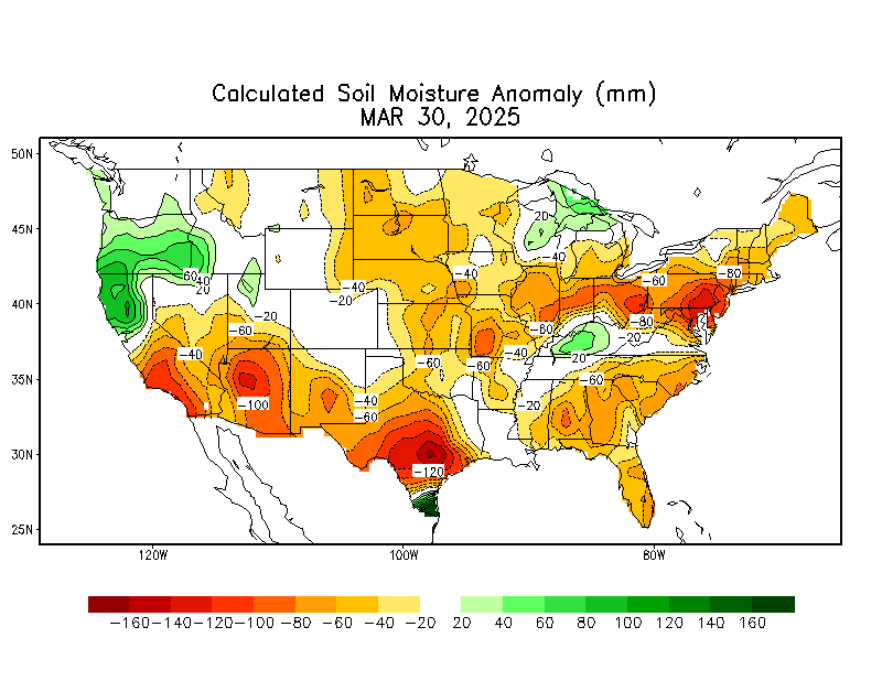
It’s been another story in 2025 as a whole. We had terrible flooding in Kentucky earlier this year. Soils still haven’t entirely recovered from the wet start to the year, and you can see it in soil moisture readings today.
Soil moisture anomalies before yesterday’s thunderstorms were already higher than normal. (NOAA CPC)
So, we look at the antecedent conditions ahead of a heavy rain event to get a sense of how much water can be absorbed initially. And the answer here is, “some but not that much.” Unfortunately, it’s not just one round of rain we’re expecting in the Ohio and Mississippi Valleys but rather several rounds between Wednesday and Saturday. Yes, there is a notable severe weather risk. But the flooding risk needs to be stressed a lot.
Not only is it significant, but it’s also potentially historic. Below is a table of the 5-day rainfall forecast from Monday morning’s run of the NWS National Blend of Models (NBM) for some Mid-South and Ohio Valley cities, as compared to their 5-day record rainfall totals historically. Currently, both Paducah and Jonesboro are forecast to exceed their prior records, while Evansville and Dyersburg, TN are only an inch off records.
Location
Forecast Wed-Sun
Standing 5-day rain record
Little Rock, AR
9.5″
12.9″ (1882)
Evansville, IN
9.8″
10.88″ (1910)
Dyersburg, TN
9.9″
10.55″ (2016)
Cape Girardeau, MO
10.4″
14.51″ (2011)
Jonesboro, AR
10.8″
10.0″ (1937)
Paducah, KY
11.0″
10.63″ (1983)
So this is not just me saying it’s going to rain a lot.
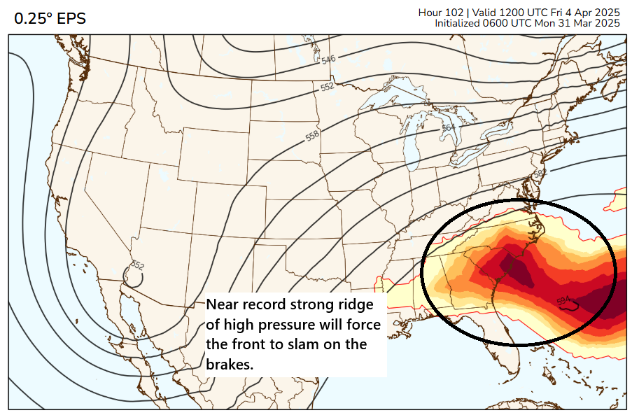
The culprit is a cold front that is going to drop into the Midwest and Mid-South on Wednesday afternoon. As this happens, it’s going to run smack into a building ridge of high pressure over the Southeast that will be approaching all-time April records.
Near-record 500 mb heights for April are likely in the Southeast and off the East Coast. This will force the cold front over the Midwest and Mid-South to stall. (PolarWx.com)
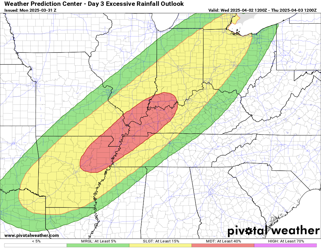
This will slow or halt the progression of the cold front, forcing it to stall out over the middle of the country, extending from roughly northeast Texas, across Arkansas and into the Ohio Valley. With a stalled front, and atmospheric moisture running very much above normal in this area, you have a recipe for a multi-round heavy rain event. The exact timing and specifics of each round are tough to pin down, but we know this much: There is a strong model signal for copious amounts of rain in the area between about Arkansas and Ohio. And the flooding risk is high enough to warrant three straight days of moderate excessive rainfall outlooks (level 3/4 Wednesday and 3/3 Thursday and Friday) from the WPC. I would expect at least one or two high risks to be issued when we approach later this week.
Wednesday’s excessive rainfall outlook includes a moderate risk (level 3 of 4) from northeast Arkansas through southwest Indiana. This area expands farther and wider on Thursday. (Pivotal Weather)
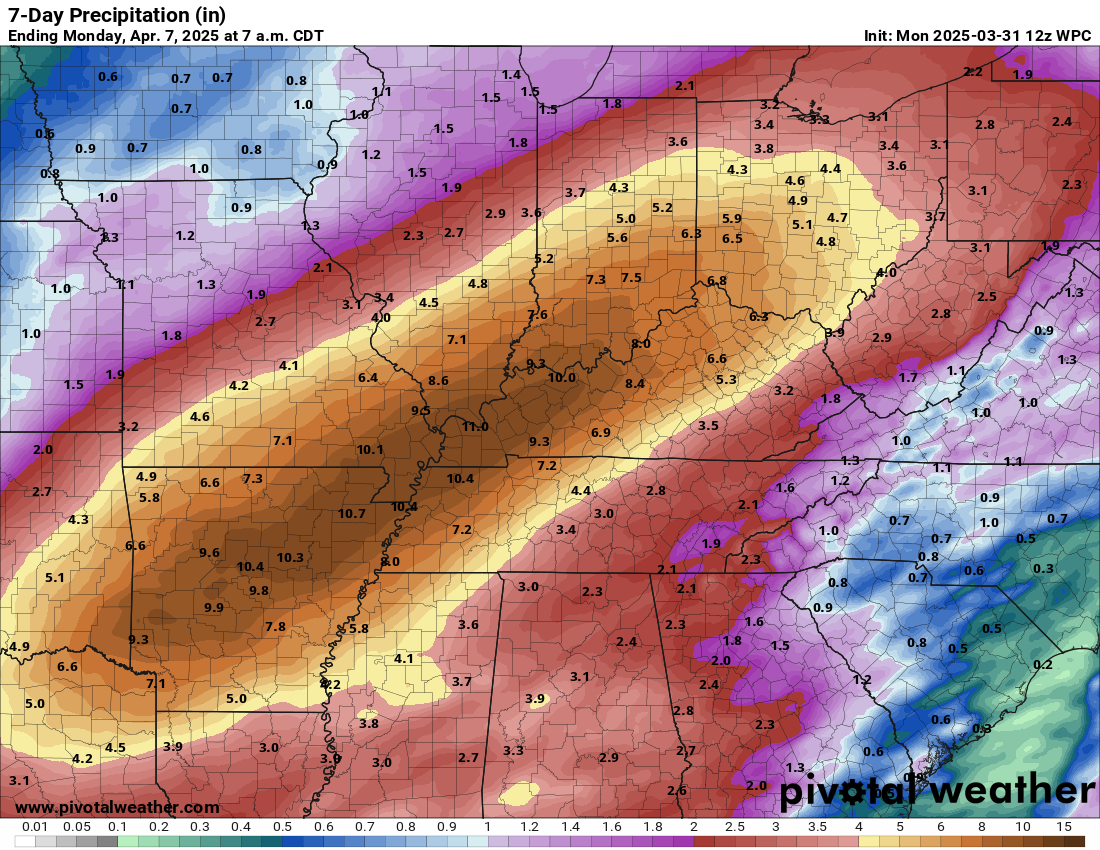
The day 4 and 5 moderate risks indicate pretty high confidence in significant flooding potential. I showed the forecast rainfall from the NBM above. That’s just one tool used, meant to show the potential for heavy rain. The current NWS Weather Prediction Center outlook for total rainfall shows a massive area of 8 to 10 inches of rain through the weekend.
Rain totals of 6 to 12 inches with higher amounts possible cover a huge swath from northeast Texas through southwest Ohio. (Pivotal Weather)
This is going to be a high impact, wide ranging, significant regional flood event. So how can this go wrong? Well, for one, you could see focused areas of rainfall embedded within the broader area, so we see some places forecast with 6 to 12 inches to see more like 2 to 4 inches with bullseyes of 10 inches or more. Much of this will depend on the strength of the Southeast ridge and where exactly the front stalls. For example, if the front ends up stalling farther north than anticipated, places like Dayton or Indianapolis or even St. Louis could see much higher rain totals, whereas if the front stalls farther south, Memphis, Nashville, or central Kentucky end up in the bullseye. That’s a shift that’s entirely within reason. So at this point while the general shape of the rainfall forecast should go unchanged, the exact placement of those bullseyes may waver some between now and Sunday.
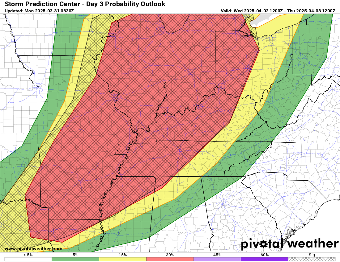
And yes, in addition to the flooding, there is a significant severe weather risk, especially on Wednesday.
The Storm Prediction Center forecast for Wednesday shows an enhanced risk (level 3/5) for the area from northeast Texas into the Great Lakes. (Pivotal Weather)
This risk is covered pretty heavily elsewhere. I’ll point you in particular to my friend Alan Gerard’s Substack, which will go in depth on all these threats in the days ahead.
This post will discuss what happened last week in the Rio Grande Valley, which saw historic rainfall in spots. We will also take a look at a growing risk of serious, possibly dangerous weather in the Midwest and Mid-South later in the upcoming week.
Anatomy of a rainfall forecast partial miss
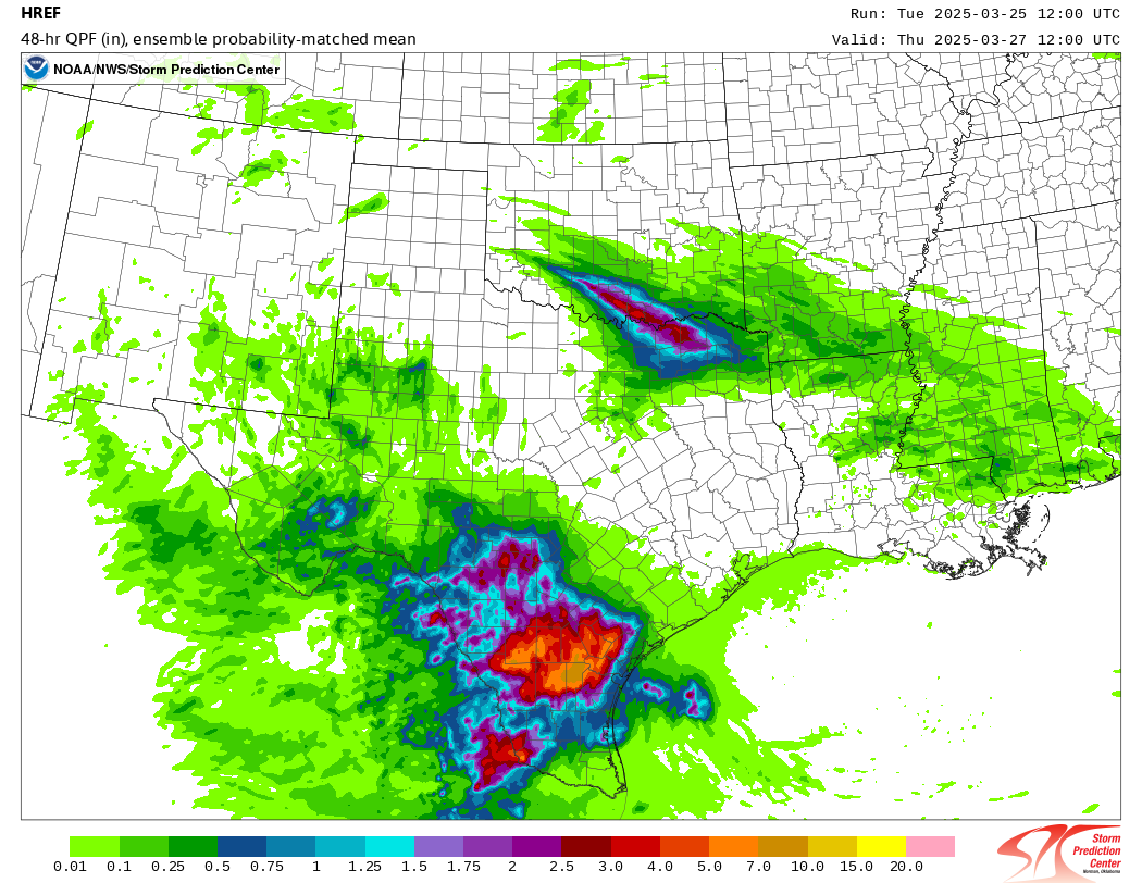
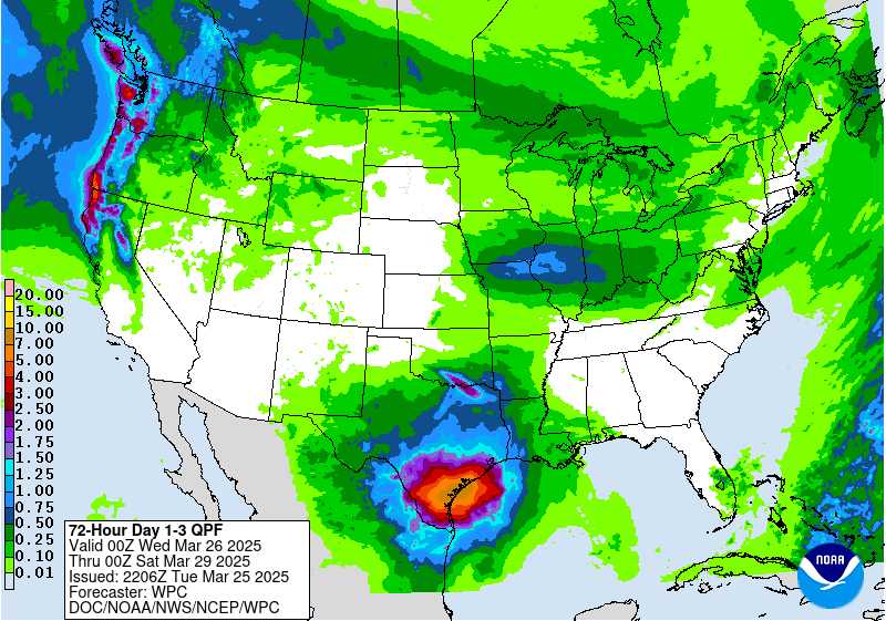
For some time leading into this past week, there were signs of, not really a pattern change, but a disruption in the stagnant, dry Texas weather pattern we’ve seen much of this year. But it was evident that a significant burst of increased rain chances would impact South Texas at least by later in the week. Indeed, by the time the models got into the high-resolution range, we could see a very strong signal for heavy rain in parts of South Texas. The probability matched mean from NOAA’s HREF model on Tuesday showed 48 hour rainfall totals in excess of 7 inches in portions of the Victoria Crossroads or Brush Country.
A very strong signal for significant rainfall in South Texas was showing up well ahead of the event, but as high resolution models came into range, the totals started to look even more concerning. (NOAA SPC)
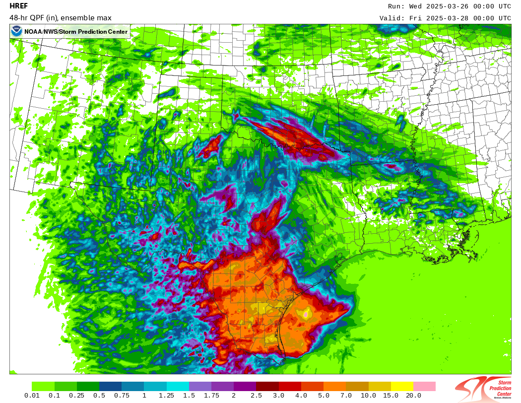
Even when you looked under the hood, this model showed potential for 10 to 15 inches of rain. This was mainly between the McAllen area east to Port Mansfield north to Victoria. By the time we got to Wednesday morning, the HREF model shown above showed potential maximum totals on the order of 5 to 15 inches over a wide swath of South Texas.
HREF ensemble max member totals exceeded 10 inches in numerous places in South Texas on Wednesday morning indicating a widespread, significant flash flood event was possible. (NOAA SPC)
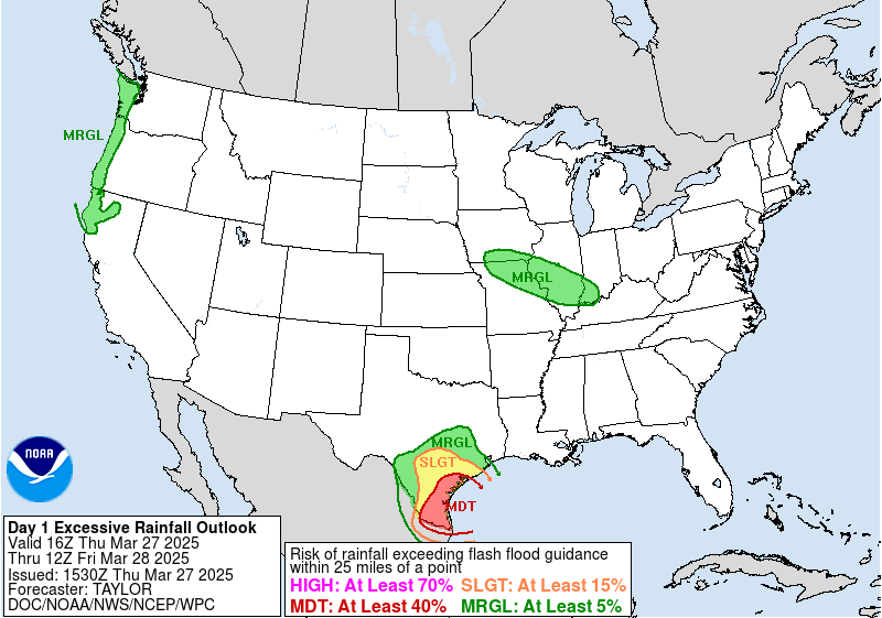
This was well captured by the excessive rainfall outlook issued on Thursday morning, showing a moderate risk (level 3 of 4) for South Texas. Previous iterations of this outlook on Wednesday had included the Lower Rio Grande Valley in the outlook but just outside the moderate risk zone. The course correction Thursday morning paid off.
Thursday morning’s updated excessive rainfall outlook, which increased the coverage of moderate risk to include the Lower RGV. (NOAA WPC)
Ahead of the event, as you can even see from the HREF modeling above, there had been a lot of focus of heavier rain totals in interior South Texas and up toward Victoria or closer to Corpus Christi. On Thursday morning, the ICON and GFS models had the bullseye near Matagorda Bay. The European model had it near Corpus. The AI model from Europe (AIFS) had it offshore. It ended up coming in much farther south than any model had.
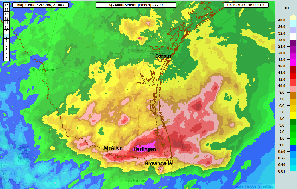
Total rainfall this week peaked just north of the Rio Grande in South Texas, with the Harlingen area hardest hit. (NOAA NSSL MRMS)
This exposes a major flaw in weather modeling today: Precipitation placement. This issue has been long standing and well known in the meteorology community. When you get major mesoscale driven (smaller, more localized forces at play) weather events like this, models often fail on precipitation placement, even if they offer a significant signal of risk and generalized location. In other words, models alerted us in this case to a strong signal that we’d have some big ticket rain totals in the double digits in South Texas. But whether that was going to occur in Victoria, Corpus Christi, or the Valley was not at all clear. The smart money play was on the area between Corpus and Victoria, much farther north than where the bullseye actually occurred. True, there were definitely areas of 4 to 8 inches of rain in that area, but that much heavier stuff whiffed way to the south.
WPC/NOAA rainfall forecast on Wednesday for the rest of the week, showing a bullseye of 4 to 8 inches between Corpus Christi and Matagorda Bay, TX (NOAA)
Indeed, the WPC forecast went that way on Wednesday. Even on Thursday, while the forecast was adjusted to the south, it was focused more offshore. The Flood Watch for the Valley was issued Wednesday evening/Thursday morning just after midnight.
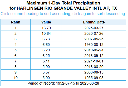
Ultimately, there was some adequate warning, but it would have been nicer to have had some additional lead time. Alas, we do the best we can with the tools we have, and in this case, there had been an indication that someone would get bombarded but not that it would be Harlingen, which smashed their all-time daily rainfall record by 3 inches. Notably, in this top 10 list of wettest days in Harlingen going back to the 1950s, every day occurred between late May and the beginning of October, not March.
It can rain like crazy in Texas any time of year, but to pull a feat like this off in March makes the rainfall record in Harlingen even more impressive. For McAllen, it was the 3rd wettest day on record, with records back to the 1940s. Unfortunately, many communities saw damage and loss of life from this event. The toll is still being tallied (both in the U.S. and in Reynosa, MX across the border), but it was another in a bad history of Texas floods.
We’ve seen this precipitation hits that also miss during bigger storms like Harvey, Florence, and others. But it’s clear that we need to continue to work on our modeling capabilities with respect to precipitation, as flooding has always been a problem and is getting worse.
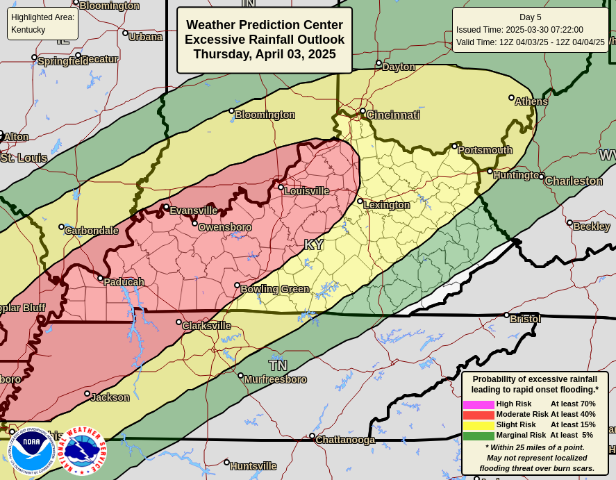
More spring flooding risk to come, this time northward
No rest for the weary. Flooding (and severe weather) are going to be hot topics over the next week or more. Today’s severe weather and flooding threat is a little more scattered over a wide area. The next really bad setup hits on Wednesday and Thursday this week. We’ll get to the severe weather outlook in a sec, but first, the rainfall risk. The day 5 excessive rainfall outlook from NOAA’s WPC on Thursday is already at a moderate (3/3) for much of the Ohio Valley.
A moderate risk (3/3) for Thursday is in place for flooding rainfall between Memphis and Cincinnati. (NOAA WPC)
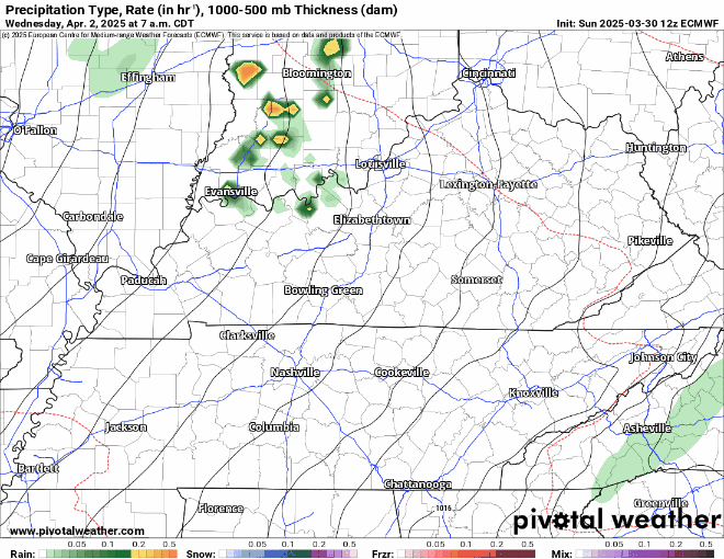
Here’s a look at a loop of Sunday morning’s European model forecast centered over Kentucky between Wednesday and Sunday, showing several, repeating rounds of thunderstorms across the Ohio Valley and points south. This is a multi-day heavy rainfall events, and the potential totals from this series of storms is significant.
European model forecast for storms between Wednesday and Sunday shows multiple rounds of heavy rain that will likely add up into at least the 4 to 8 inch range. (Pivotal Weather)
In addition, the severe weather risk on Wednesday is already significant. There seems to be a good deal of model support on Wednesday for developing severe thunderstorms across the Mississippi and Ohio Valleys. Modes look to vary between potential for supercells capable of strong tornadoes and large hail and more “lined out” structure that would carry more of a damaging wind threat. But the signals are all there, leading the Storm Prediction Center to highlight a 30% risk on day 4. I would anticipate this to lead to an enhanced risk to open the bidding tomorrow, with potential for a moderate risk (4/5) before all is said and done.
Severe weather risk on Wednesday in particular looks significant between the Arklatex and potentially Lower Michigan. (NOAA SPC)
Between the storms and the potential for developing flooding, it appears the Wednesday through weekend period is going to be one of those more enhanced time periods to remain weather aware in parts of the Midwest, Mid-South, and Deep South.
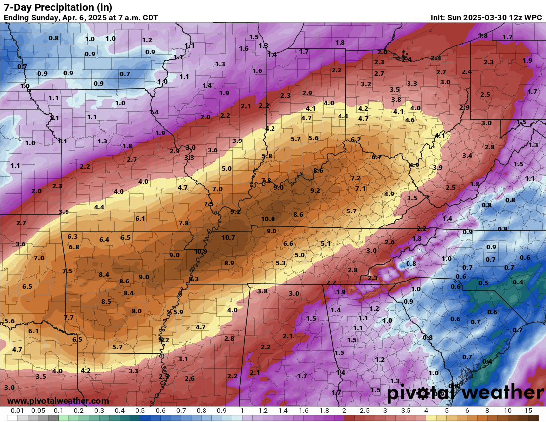
Total rainfall between today’s storms and what we see to close next week may be on the order of 5 to 10 inches.
Potential total rainfall between Sunday and Sunday in the Ohio and Mississippi Valleys. (Pivotal Weather)
I have to be frank here: Both AI modeling and the traditional ensemble models are in strong agreement on this type of map. Historically, those models tend to underdo rain amounts this far out in this type of setup. So while the expectation is 5 to 10 inches, it seems likely that some places will exceed those values, and those are the areas that could see even more significant, potentially dangerous flooding. This is an event you’ll want to continue to follow closely.
As we navigate the world right now, we have an obligation to keep our readers informed on the news of the day as it relates to weather forecasting. After all, if you are using this site and others for weather forecast information, you have an interest. But there’s a lot of news out there, and a lot of opinions masquerading as news. No matter your political leanings, the “zone” as it were is flooded and trying to piece together facts vs. stretched truths can be difficult in any ideology. So, periodically I think it helps to take a step back and assess a topic as realistically as possible. This is meant to be as unbiased a look as possible at one topic of note: Weather balloon launches being cut.
What is happening?
Due to staffing constraints, as a result of recent budget cuts and retirements, the National Weather Service has announced a series of suspensions involving weather balloon launches in recent weeks.
In a normal time, weather balloons would be launched across the country and world twice per day right at about 8 AM ET and 8 PM ET (one hour earlier in winter), or what we call 12z and 00z. That’s Zulu time, or Noon and Midnight in Greenwich, England. Rather than explain the whole reasoning behind why we use Zulu time in meteorology, here’s a primer on everything you need to know. Weather balloons are launched around the world at the same time. It’s a unique collaboration and example of global cooperation in the sciences, something that has endured for many years.
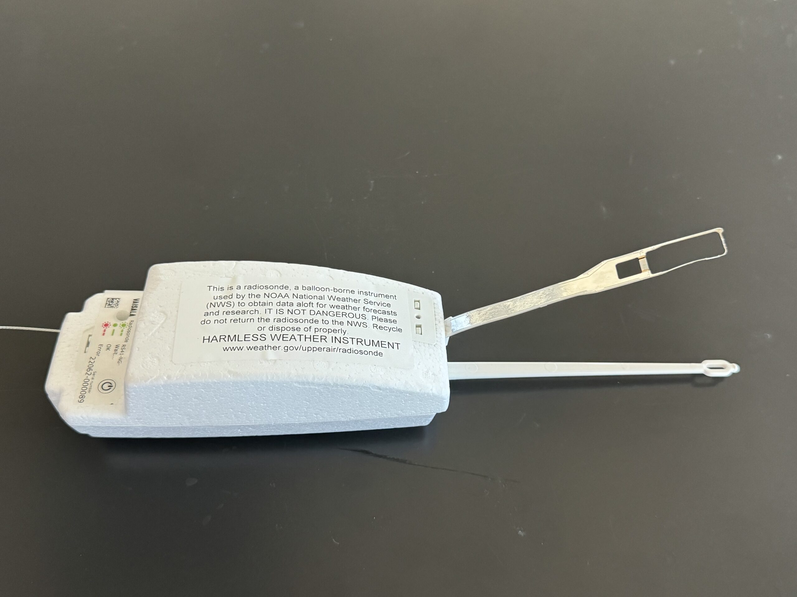
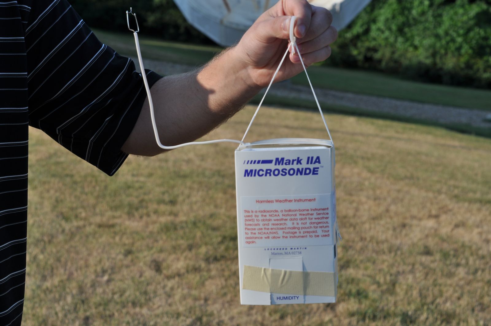
These weather balloons are loaded up with hydrogen or helium, soar into the sky, up to and beyond jet stream level, getting to a height of over 100,000 feet before they pop. Attached to the weather balloon is a tool known as a radiosonde, or sonde for short. This is basically a weather sensing device that measures all sorts of weather variables, like temperature, dewpoint, pressure, and more. Wind speed is usually derived from this based on GPS transmitting from the sonde. What goes up must come down, so when the balloon pops, that radiosonde falls from the sky. A parachute is attached to it, slowing its descent and ensuring no one gets plunked on the head by one. If you find a radiosonde, it should be clearly marked, and you can keep it, let the NWS know you found it, or dispose of it properly. In some instances, there may still be a way to mail it back to the NWS (postage and envelope included and prepaid).
A radiosonde with mailing instructions. (NWS Pittsburgh)
What does the data from weather balloons do?
In order to run a weather model, you need an accurate snapshot of what we call the initial conditions. What is the weather at time = zero? That’s your initialization point. Not coincidentally, weather models are almost always run at 12z and 00z, to time in line with retrieving the data from these weather balloons. It’s a critically important input to almost all weather modeling we use. The data from balloon launches can be plotted on a chart called a sounding, which gives meteorologists a vertical profile of the atmosphere at a point. During severe weather season, we use these observations to understand the environment we are in, assess risks to model output, and make changes to our own forecasts. During winter, these observations are critical to knowing if a storm will produce snow, sleet, or freezing rain. Observations from soundings are important inputs for assessing turbulence that may impact air travel, marine weather, fire weather, and air pollution. Other than some tools on some aircraft that we utilize, the data from balloon launches is the only real good verification tool we have for understanding how the upper atmosphere is behaving.
Haven’t we lost weather balloon data before?
We typically lose out on a data point or two each day for various reasons when the balloons are launched. We’ve also been operating without a weather balloon launch in Chatham, MA for a few years because coastal erosion made the site too challenging and unsafe. Tallahassee, FL has been pausing balloon launches for almost a year now due to a helium shortage and inability to safely switch to hydrogen gas for launching the balloons. In Denver, balloon launches have been paused since 2022 due to the helium shortage as well.
Those are three sites though, spread out across the country. We are doubling or tripling the number of sites without launches now, many in critical areas upstream of significant weather.
Can’t satellites replace weather balloons?
Yes and no. On one hand, satellites today are capable of incredible observations that can rival weather balloons at times. And they also cover the globe constantly, which is important. That being said, satellites cannot completely replace balloon launches. Why? Because the radiosonde data those balloon launches give us basically acts as a verification metric for models in a way that satellites cannot. It also helps calibrate derived satellite data to ensure that what the satellite is seeing is recorded correctly.
But in general, satellites cannot yet replace weather balloons. They merely act to improve upon what weather balloons do. A study done in the middle part of the last decade found that wind observations improved rainfall forecasts by 30 percent. The one tool at that time that made the biggest difference in improving the forecast were radiosondes. Has this changed since then? Yes, almost certainly. Our satellites have better resolution, are capable of getting more data, and send data back more frequently. So certainly it’s improved some. But enough? That’s unclear.
An analysis done more recently on the value of dropsondes (the opposite of balloon launches; this time the sensor is dropped from an aircraft instead of launched from the ground) in forecasting west coast atmospheric rivers showed a marked improvement in forecasts when those targeted drops occur. Another study in 2017 showed that aircraft observations actually did a good job filling gaps in the upper air data network. Even with aircraft observations, there were mixed studies done in the wake of the COVID-19 reduction in air travel that suggested no impact could be detected above usual forecast error noise or that there was some regional degradation in model performance.
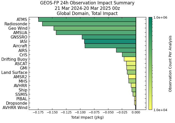
The element with the second highest impact on the NASA GEOS model? Radiosondes. (NASA)
But to be quite honest, there have not been a whole lot of studies that I can find in recent years that assess how the new breed of satellites has (or has not) changed the value of upper air observations. The NASA GEOS model keeps a record of what data sources are of most impact to model verification with respect to 24 hour forecasts. Number two on the list? Radiosondes. This could be considered probably a loose comp to the GFS model, one of the major weather models used by meteorologists globally.
What’s the verdict?
In reality, the verdict in all this is to be determined, particularly statistically. Will it make a meaningful statistical difference in model accuracy? Over time, yes probably, but not in ways that most people will notice day to day.
However, based on 20 years of experience and a number of conversations about this with others in the field, there are some very real, very serious concerns beyond statistics. One thing is that the suspended weather balloon launches are occurring in relatively important areas for weather impacts downstream. A missed weather balloon launch in Omaha or Albany won’t impact the forecast in California. But what if a hurricane is coming? What if a severe weather event is coming? You’ll definitely see impacts to forecast quality during major, impactful events. At the very least, these launch suspensions will increase the noise to signal ratio with respect to forecasts.
In other words, there may be situations where you have a severe weather event expected to kickstart in one place but the lack of knowing the precise location of an upper air disturbance in the Rockies thanks to a suspended launch from Grand Junction, CO will lead to those storms forming 50 miles farther east than expected. In other words, losing this data increases the risk profile for more people in terms of knowing about weather, particularly high impact weather.
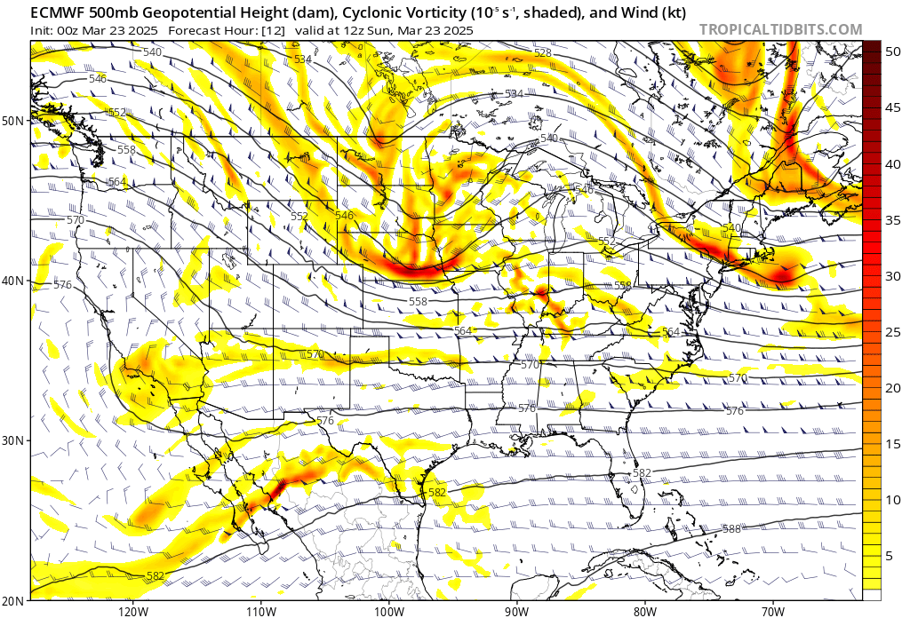
A map of what’s happening 20,000 feet over our heads this morning, showing a strong disturbance exiting an area where upper air observations were sparse yesterday and this morning. An example of a situation where those would be helpful. (Tropical Tidbits)
Let’s say we have a hurricane in the Gulf that is rapidly intensifying, and we are expecting it to turn north and northeast thanks to a strong upper air disturbance coming out of the Rockies, leading to landfall on the Alabama coast. What if the lack of upper air observations has led to that disturbance being misplaced by 75 miles. Now, instead of Alabama, the storm is heading toward New Orleans. Is this an extreme example? Honestly, I don’t think it is as extreme as you think. We often have timing and amplitude forecast issues with upper air disturbances during hurricane season, and the reality is that we may have to make some more frequent last second adjustments now that we didn’t have to in recent years. As a Gulf Coast resident, this is very concerning.
I don’t want to overstate things: Weather forecasts aren’t going to dramatically degrade day to day because we’ve reduced some balloon launches across the country. They will degrade, but the general public probably won’t notice much difference 90 percent of the time. But that 10 percent of the time? It’s not that the differences will be gigantic. But the impact of those differences? That could very well be gigantic, put more people in harm’s way, and increase the risk profile for an awful lot of people. That’s what this does: It increases the risk profile, it will lead to reduced weather forecast skill scores, and it may lead to an event that surprises a portion of the population that isn’t used to be surprised in the 2020s. To me, that makes the value of weather balloons very, very significant, and I find these cuts to be extremely troubling.
One addendum that I have edited to add: This is our current situation. It’s a static look at a fluid problem. Should further cuts in staffing lead to further suspensions in weather balloon launches, we will see this problem magnify more often and involve bigger misses. In other words, the impacts here may not be linear, and repeated increased loss of real-world observational data will lead to very significant degradation in weather model performance that may be noticed more often than described above.