In brief: A quick Monday table setter to discuss severe weather today, flooding concerns that are coming up, and an early season heat wave on the East Coast. Eastern Pacific hurricane season is also officially underway.
Tropical concerns: None.
Eastern Pacific hurricane season began on Friday, and it looks quiet for the time being. Nothing on the Atlantic side to get us stirred up either. Look for part 3 of our 2025 Atlantic season in review on Wednesday.
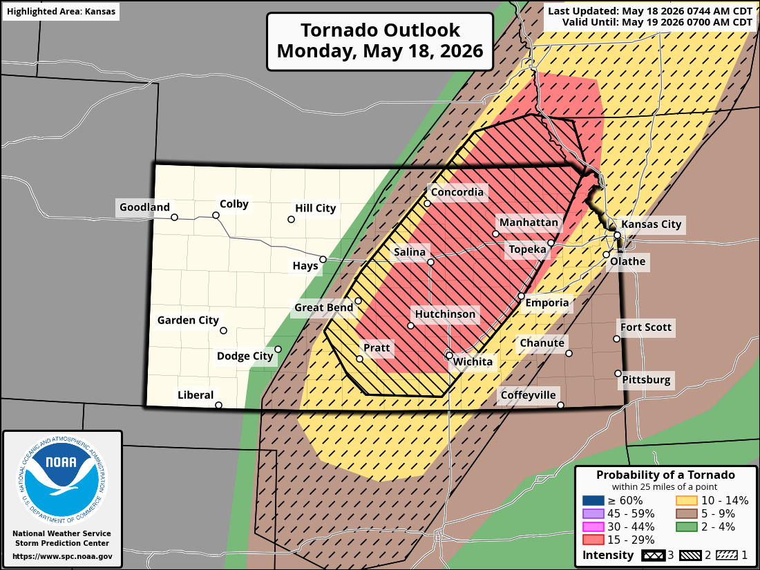
Severe weather concerns: Moderate risk today Kansas/SE Nebraska
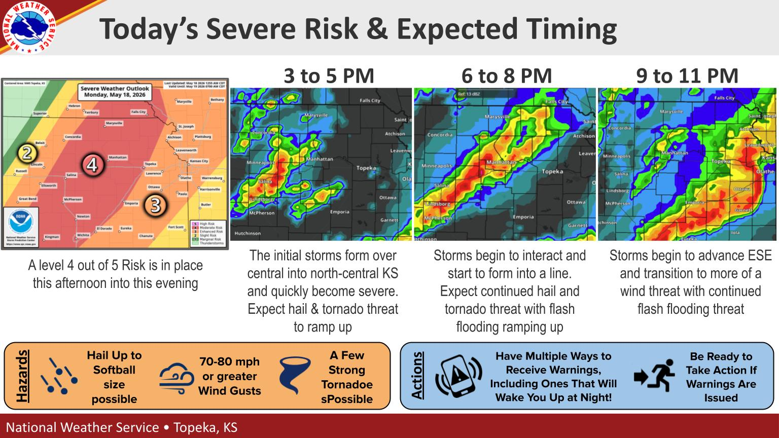
A moderate risk (level 4/5) is in place today for much of central and northeast Kansas, as well as southeast Nebraska. The risk today is for significant hail and strong tornadoes in this area.
Significant tornado risk exists today from near Wichita through southeast Nebraska. (NOAA SPC)
Storms should develop later this afternoon and advance east across Iowa and Missouri. Much of those areas are in enhanced (3/5) and slight (2/5) risk as well. So there is substantial risk for damaging thunderstorms today and tonight in these regions.
(NWS Topeka)
Storms will advance south and east tomorrow where a very broad slight risk (2/5) is in place from Upstate New York into Texas.
Flooding concerns: Central U.S., including Texas
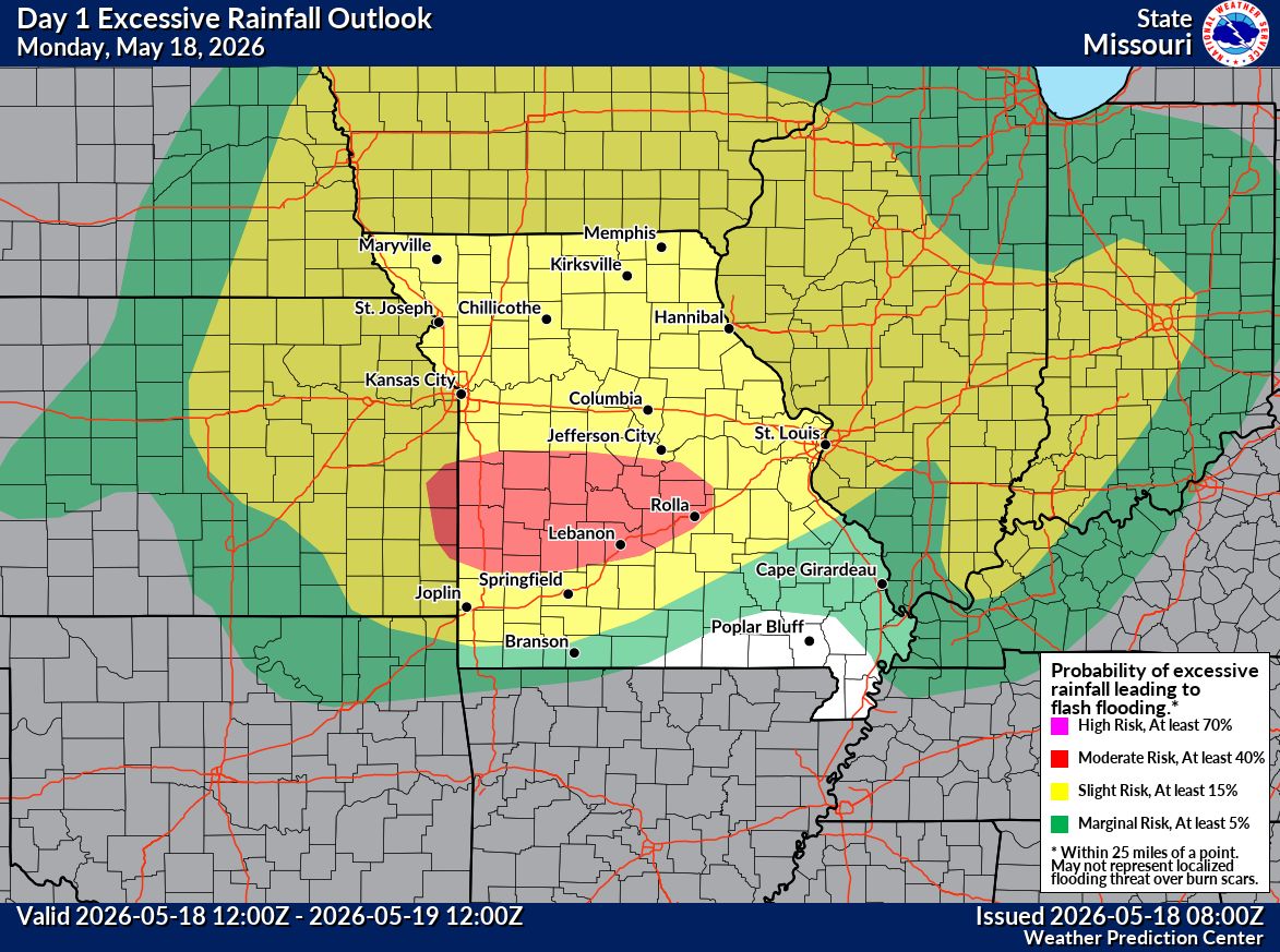
Storms today will cause localized flash flooding from Kansas into Iowa and Minnesota but also a bullseye in Missouri. In these areas a “slight” risk (2/4) is in place for excessive rainfall and flooding, except a moderate risk (3/4) in Missouri.
A moderate risk of flooding south of Columbia, MO, with significant heavy rain falling and expected to continue tonight. (NWS WPC)
Flood watches are posted in this area.
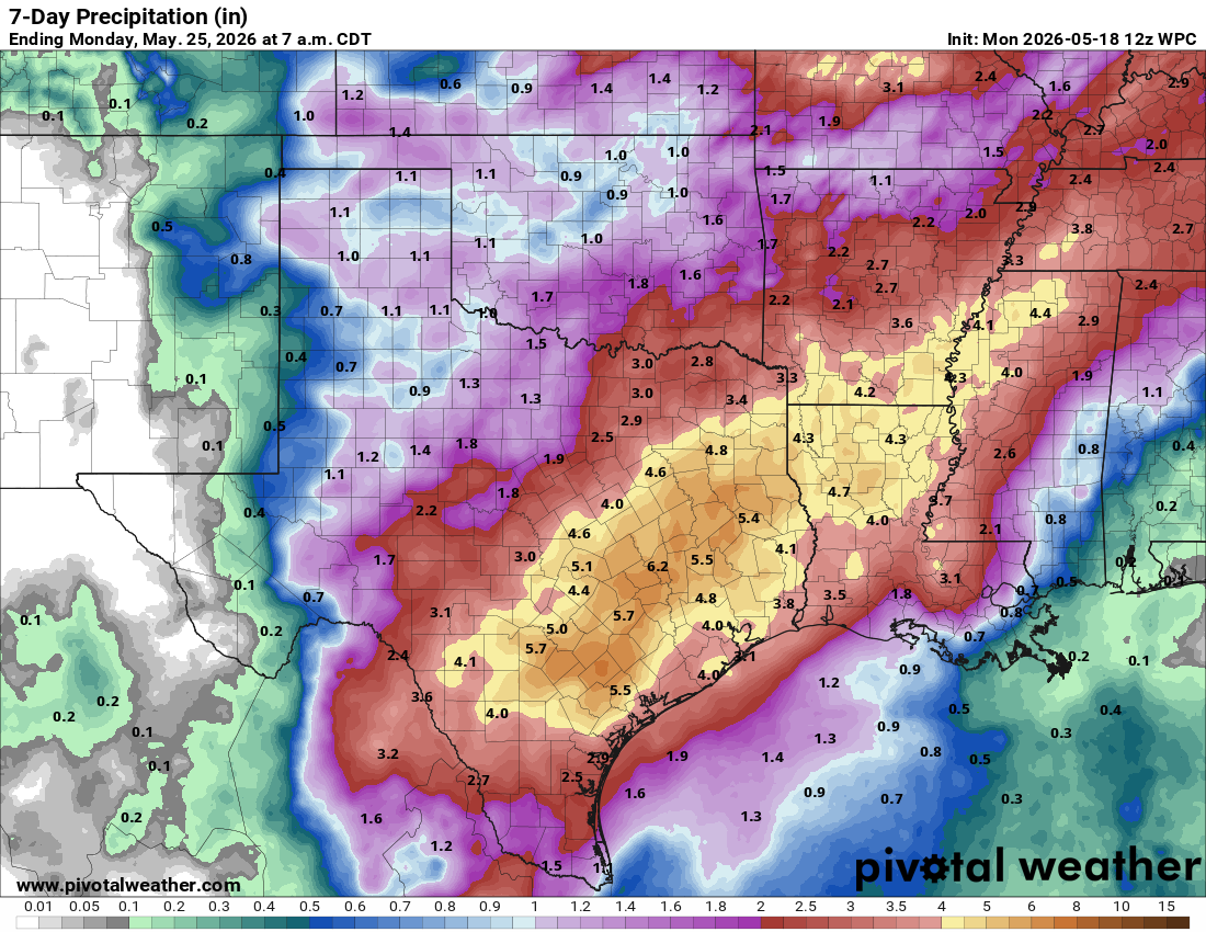
As that system exits to the east, the setup over the Central U.S., from about Texas into the Ohio Valley and Southeast is going to favor continuous moisture coming in off the Pacific, Gulf of Mexico, and Caribbean Sea. This will lead to repeated rounds of rain and thunderstorms beginning tomorrow and continuing probably into next week in these areas. Rainfall totals will probably add up to 4 to 8 inches over a broad area in that 7 to 10 day period.
Forecast rainfall from NWS over the next 7 days. Additional rain will follow this, and locally higher amounts are possible, especially in southwest Louisiana and southeast Texas. (Pivotal Weather)
In localized spots, we could see some flash flooding concerns ramp up, including portions of Louisiana and the Houston area in Texas. We could also see some larger rivers begin to flood as well. We’ll be monitoring the rain chances for Houston closely at Space City Weather. But this looks like a major, prolonged and drought-busting rain event across the South and Ohio Valley. We will likely have more to come on this either here or at Space City Weather.
One other additional note:Corpus Christi has been in the news a lot lately because of the potentially devastating water shortage issues in that area. While this will not end those concerns at all, 1 to 4 inches of rain would help a lot in the near-term. Most models show this as a plausible outcome, though the heavier rains will be focused northeast of there. Hopefully with a developing El Niño, the rains will occur more frequently, though flooding concerns may emerge more frequently too.
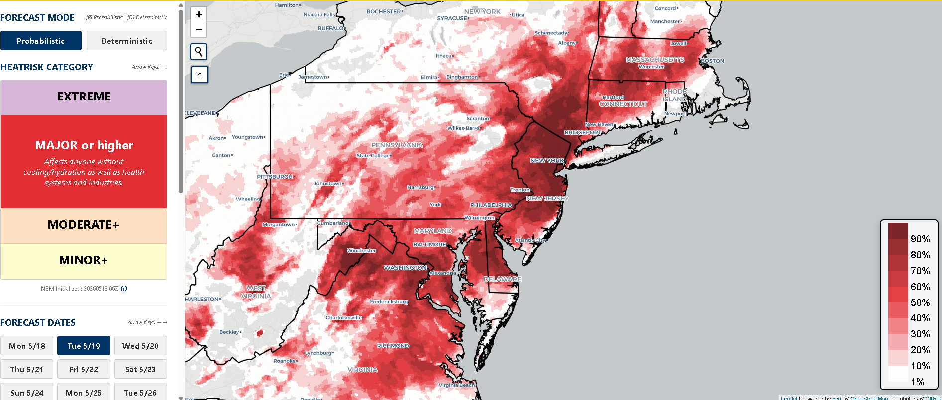
Heat concerns: Northeast Corridor
Not necessarily out of the ordinary, but an early season heat wave is going to impact parts of the Northeast Corridor, especially between New York City and Richmond, Virginia the next couple days. Yesterday was a taste of things with 89 degrees recorded in New York, Philadelphia, and Washington. Today and tomorrow should be worse. Forecast highs are in the mid-90s for DC and Philly today and tomorrow and perhaps mid-90s into New York and Boston tomorrow.
Probability of “major” heat risk on Tuesday in the Northeast and Mid-Atlantic. (NOAA)
Tuesday should be the hotter of the two days overall, and the NWS heat risk map above shows pretty high probabilities of “major” risk (level 3/4) over a broad area. Heat should end on Wednesday evening with a cold front slamming through the region.
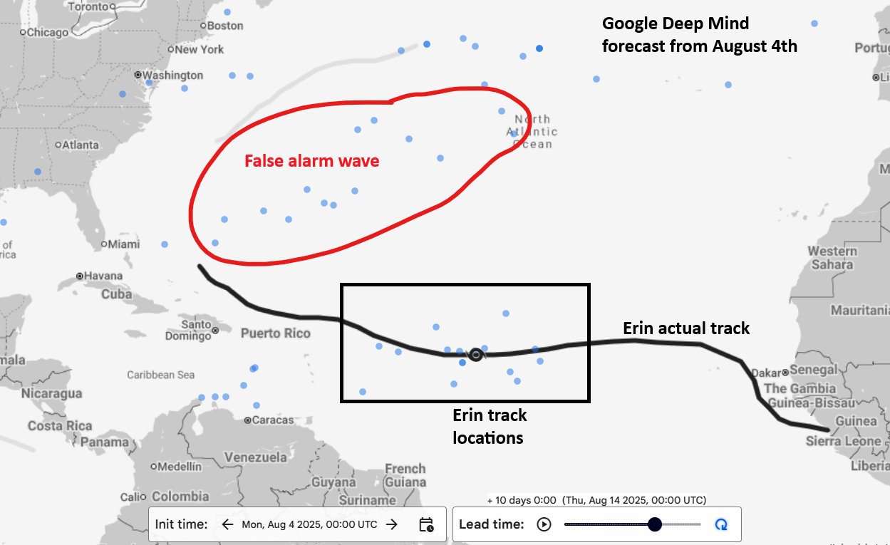
The first signs of Erin came a bit late in the game. We had been tracking a system in front of where Erin would develop that was highlighted in NHC outlooks as far in advance as August 2 or 3. As noted in our previous season in review post, there were a few cases of false alarms last season from the European model in particular, and that was one.
Google’s Deep Mind model did capture the potential for Erin well in advance. In fact, a week before genesis, Google Deep Mind’s model showed both risk of Erin, as well as the false alarm wave we had been monitoring ahead of Erin.
Google Deep Mind August 4, 2025 forecast with Erin’s actual track and the “false” system several models showed as well. (Google Weather Lab)
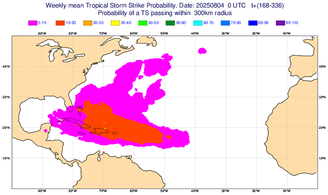
So no models were immune from false alarms, but the consensus on Erin gradually picked up as time went on. On August 5th, we noted how the European weekly model had a higher area of activity potential near the Caribbean as well.
European weekly tropical storm probabilities from August 4th, showing slightly elevated odds in the Caribbean with what would become Erin. (ECMWF)
By August 8th, speculation on future Erin had begun increasing, with some operational model guidance bringing Erin as far west as the Southeast U.S. By the 9th, we had Invest 96L from the false alarm wave ahead of Erin, with diminishing development odds. But odds on Erin were increasing. Models were in great agreement on potential for a system and a stronger one, and things just kind of progressed from there.
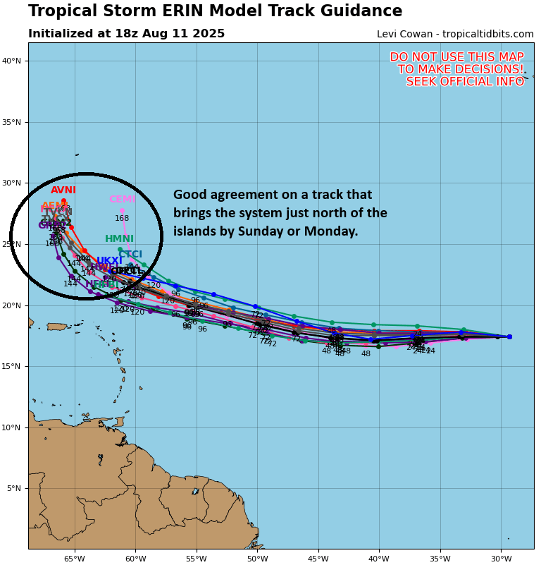
Erin was dubbed Invest 97L before formation, with the biggest forecast uncertainty on how much space it would have to turn northwest once near the Caribbean islands. By the morning of the 11th, confidence in that turn northward was increasing, and Erin was classified as a tropical storm that afternoon.
Erin’s forecast had really good agreement on track and many models projected a high-end category 3 or 4 hurricane by this time. (Tropical Tidbits)
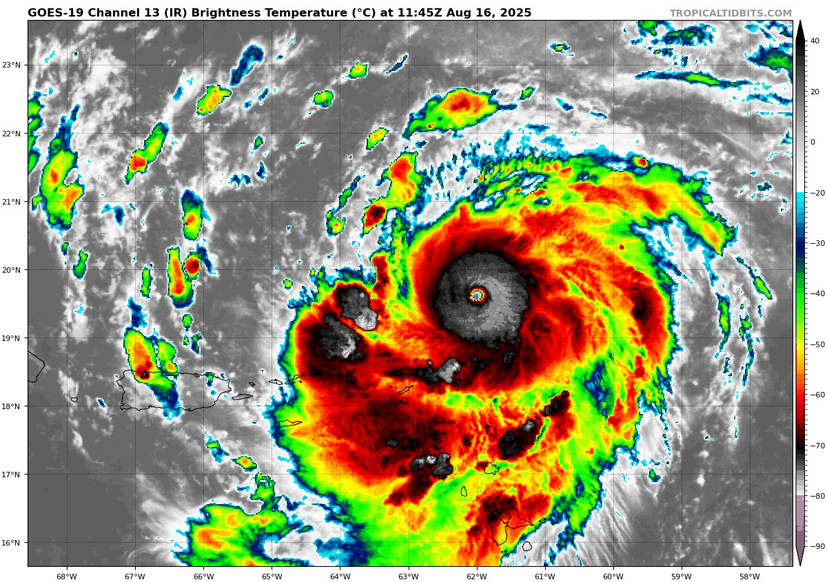
Erin struggled out of the gate, with most of its thunderstorm activity abandoned by the morning of the 12th. Two days later, Erin had put itself together nicely with a much nicer satellite presentation and the beginnings of organization. 48 hours after it had 50 mph sustained winds, early on the 14th, it had jumped to 110 mph winds early on the 16th. It then peaked in intensity on the afternoon of the 16th as a 160 mph category 5 storm.
Erin’s satellite loop just before attaining category 5 intensity on the 16th of August. (Weathernerds.org)
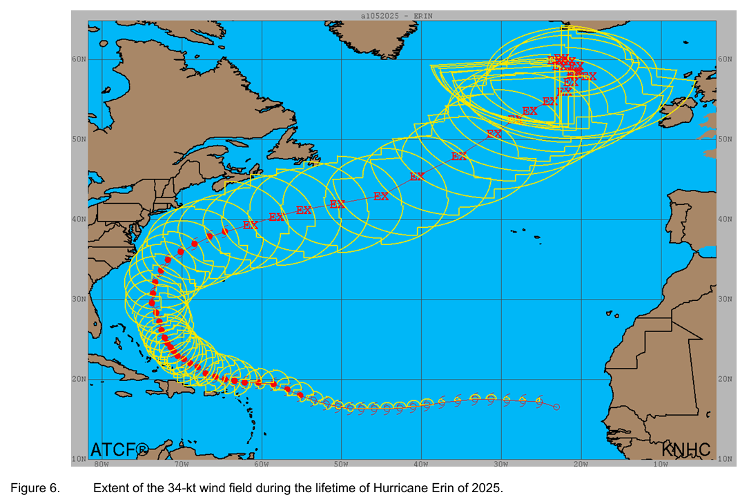
As Erin moved northwest and then northward, it grew in size, eventually reaching the 92nd to 95th percentile of all hurricanes on record north of 20°N latitude.
Erin’s enormous size shown from the post-storm report. (NOAA NHC)
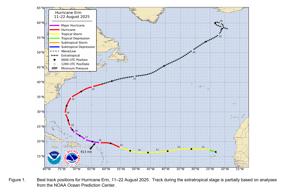
Despite the size, the strongest wind report at any land location came from Anegada in the British Virgin Islands, which had 61 mph sustained winds, gusting to 74 mph. Erin’s size did allow for some tropical storm force wind gusts to occur from New Jersey through North Carolina in addition to widespread coastal flooding. Impacts from Erin included severe rain and several drowning deaths in the Cabo Verde Islands, as well as flooding and landslides in the British Virgin Islands. Two structures in Buxton, NC sustained major damage, with around $3.1 million in damage from North Carolina and $25 million in total damage. Thirteen deaths (including the 7 noted above) can be attributed to Erin.
(NOAA/NHC)
For track forecasts, the HAFS-A model, Google Deep Mind model, and the HCCA consensus model seem to have been the best performers for Erin. For intensity, the backpat probably goes to the consensus models, the HMON, and Google’s Deep Mind. Read the full report here.
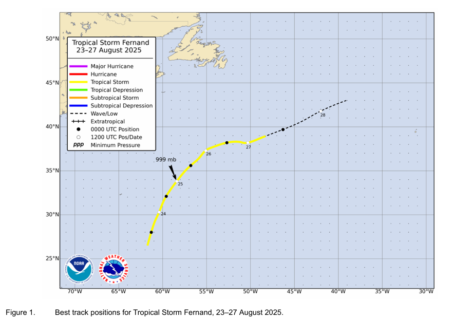
Tropical Storm Fernand (August 23-27)
Our sixth storm of the season, Fernand was a classic low-end fish storm. Maximum winds reached just about 60 mph, and there was no damage reported as it stayed out at sea. Still, Fernand was actually pretty well forecast, having probabilities of development added several days in advance.
(NOAA/NHC)
Google’s Deep Mind model again performed well here, as did some other model guidance. But aside from that, there was little of note to discuss with Fernand.
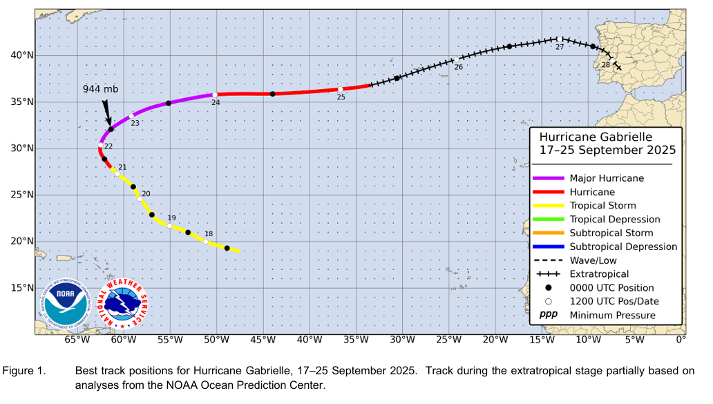
Hurricane Gabrielle (September 17-25)
We went several weeks again with little in the way of tropical activity in the Atlantic, through and beyond the peak date of September 10th, an extremely unusual feat. This was not a surprise in the moment, however. On August 23, we discussed the quiet that was expected in the Atlantic for the upcoming 2 to 3 weeks. In that gap we did have several waves emerge with some development odds — and they failed. One consistent theme of 2025’s hurricane season was a lot of false alarm noise.
(NOAA/NHC)
Things picked back up in the back half of September with Gabrielle. Some signs of this began to emerge late in the first week of September on the modeling. The first NHC notation on the system to become Gabrielle did occur nearly 7 days in advance with slowly, steadily increasing odds of development as time went on. Overall, Gabrielle was well predicted in advance, perhaps the best of 2025.
Gabrielle skipped the depression phase and jumped right into tropical storm status on the 17th. At the time, the NHC had classified it as a depression, but in the post-storm analysis, it was determined that Gabrielle didn’t have a firm center at that time and had actually reformed one to the north of where it had originally been analyzed which means it actually became a tropical storm around the afternoon of the 17th, not a depression the morning of. Every scientific field has their nuances to iron out, and this is one of them in meteorology.
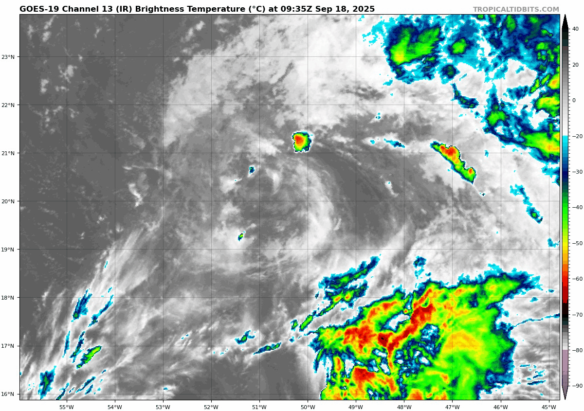
Gabrielle was not exactly pretty looking early in its life cycle, as you can see from September 18th. (Tropical Tidbits)
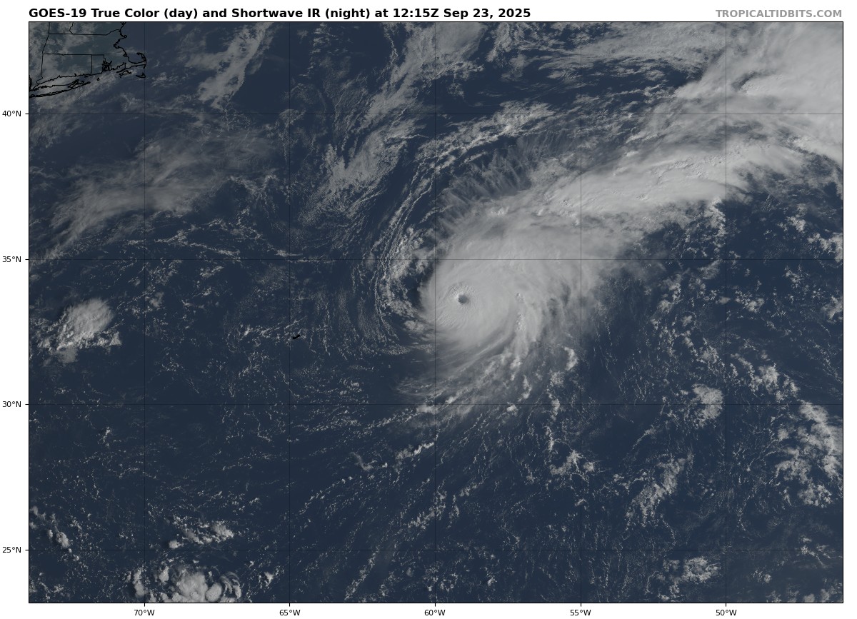
Gabrielle pressed off to the northwest over the next few days, struggling, slowing, and turning north and northeast to the east of Bermuda. Gabrielle underwent a spurt of rapid intensification, strengthening from a 65 mph tropical storm early in the morning of the 21st to 90-95 mph on the morning of the 22nd to 140 mph on the morning of the 23rd.
Gabrielle near peak intensity in the open Atlantic. (Tropical Tidbits)
Gabrielle tracked off to the northeast and east over the next few days, arriving in the Azores around the 26th. One site (Faial) reported sustained winds of 48 mph, gusting to 96 mph as Gabrielle’s non-tropical circulation arrived. There was even a report of 115 mph winds in the mountains atop one of the islands there. Thankfully, damage was limited. Gabrielle continued as a remnant low into Portugal before dissipating.
Google’s Deep Mind model did great with Gabrielle’s track forecast, but virtually no other models beat the NHC’s track or intensity outlook within 120 hours.
In brief: Today’s post looks at hurricane season now that we’re 3 weeks out. What does a strong or super El Niño actually mean in terms of numbers compared to history? And what, if anything, is different about this season?
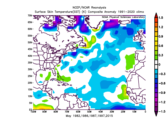
We’re exactly 3 weeks from the start of hurricane season. The news has been pumping this upcoming El Niño event, which may actually be worth the hype when all is said and done. It does look quite significant, and that will have global impacts. And we know generally that El Niño tilts the odds in favor of a less active hurricane season than usual. A strong El Niño on the order of a 1982-83 or 1997-98 seems plausible.
El Niño is slowly emerging in the Tropical Pacific, but only a couple hundred meters below the surface, even warmer waters are lurking. (NOAA)
If we break down Atlantic hurricane seasons back to 1980 and focus on just strong-er El Niño events, not even just the strongest ones, here’s what you get. And consider these approximate values, not official ones; definitions of when El Niño or La Niña start can vary based on metric used, and no single one is perfect. The intent here is to show you the difference between stronger El Niños, all El Niños and La Niñas when compared to average seasons.
Average of Seasons
Strong-er El Niño
All El Niño
All La Niña
Average Season
Named Storms
7.5
9.5
15.9
14.4
Hurricanes
3.2
3.8
8.1
7.2
Major Hurricanes
0.8
1.5
3.4
3.2
Accumulated Cyclone Energy (ACE)
39.6
56.4
127.1
123
El Niño events such as the one we expect will emerge in the next few months historically, if not dramatically depress hurricane seasons. Even when compared to all El Niño events, the stronger ones are even more muted.
So, it’s safe to say that you should shrug this hurricane season off, right? Well, maybe not entirely.
Yes, this should probably be a less active hurricane season, and in all likelihood, it will be even less active than the last two seasons which were odd in and of themselves. But there’s one interesting, rather big difference between years going into stronger El Niño summers and this one. And that is global water temperatures.
Average of SST anomalies in May preceding significant El Niño events that emerged in summer. (NOAA)
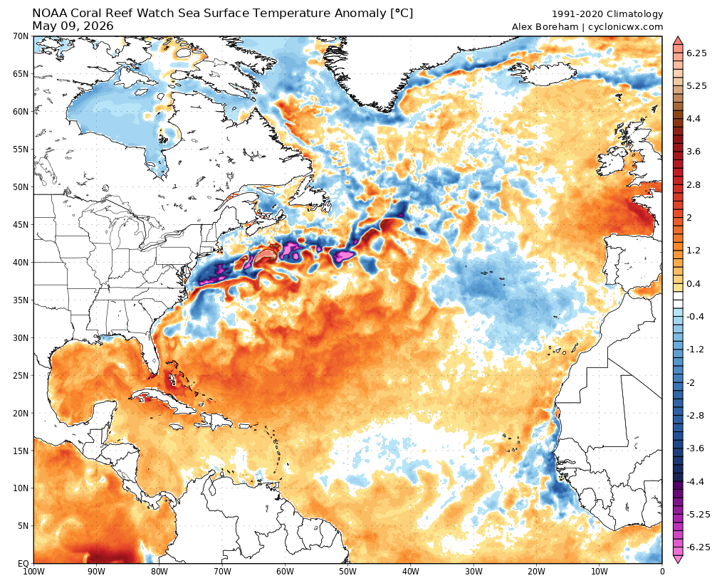
Historically, we’ve had a slightly warmer than normal Gulf of Mexico and southwest Atlantic and a fairly widespread below average Atlantic main development region. This year? Not quite that cool.
SST anomalies as of May 9th. (Cyclonicwx.com)
We still see the warm Gulf and very warm Bahamas. The MDR? On par with historical pre-Niño summers. But the Atlantic subtropics are much warmer than normal. But it’s less about the shape and more about the amplitude, I think. According to Dr. Kim Wood’s charts from the University of Arizona, the Gulf? Near record levels for this time of year. The MDR? Near average. Subtropics? Near records. (As an aside, the eastern North Pacific is going to be primed for what could be a wild hurricane season between Mexico and Hawaii)
What does this mean? Well, sea surface temperatures alone will not get you massive amounts of storms. The last 2 years have more than proven that. However, what they can do is boost the odds a little higher than usual. So if a typical stronger El Niño summer would usually see an 8/3/1 slash line for storms, hurricanes, and majors, maybe a summer like this has a storm or two of upside. It’s like performance enhancing drugs in baseball. As a player, you should hit a certain number of home runs based on your strength and skills. But if you add enhancers, well, you’ve just bumped up your odds of hitting the ball a little farther and a little harder now when you do make contact. Warm SSTs can do that for tropical systems: When the conditions come together, maybe you can snag an extra named storm or a major hurricane now.
So that’s why I think this hurricane season will still more than likely be less active than usual, but maybe with a touch more upside risk to the storm numbers than in a typical stronger El Niño.
Regardless, if the only storm we get all season is a category 4 that hits a populated part of the coast, that’s a bad season, and it’s why if you live along the coast you should prepare for this season as you would any other season. Hope for the best, but prepare just in case.
In brief: We begin a look back at the 2025 Atlantic Hurricane Season, as we dive in on Tropical Storm Andrea and conclude with Tropical Storm Dexter and a deeper look at why the season went so calm.
Welcome to our hurricane season in review. There’s always weather to talk about, but since our bread and butter is tropical weather here at The Eyewall, it makes sense to recap the previous season. As these storms develop, sometimes things move really fast, and you’re so focused on the potential impacts of the storms that it’s tough to take stock of what’s happening. A recap allows you a slower walk through the season. Much of what is taken here is some additional context from posts we made in the middle of the event, as well as from National Hurricane Center post-storm reports. We’ll plan to post our 3-parts over the next 3 weeks, as we’re just over a month from the start of hurricane season, a reminder to begin to think about preparedness.
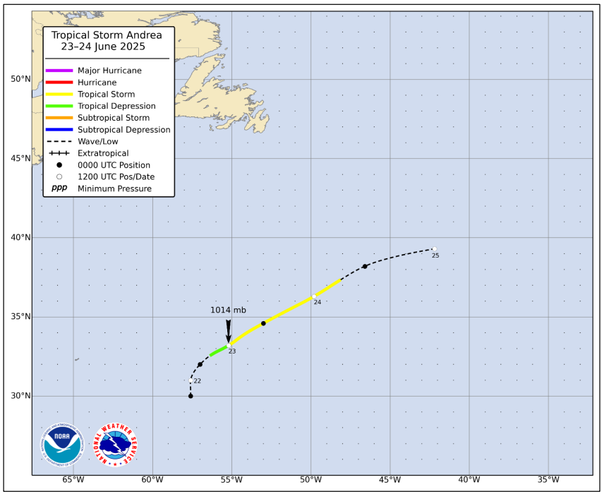
Tropical Storm Andrea (June 23-24)
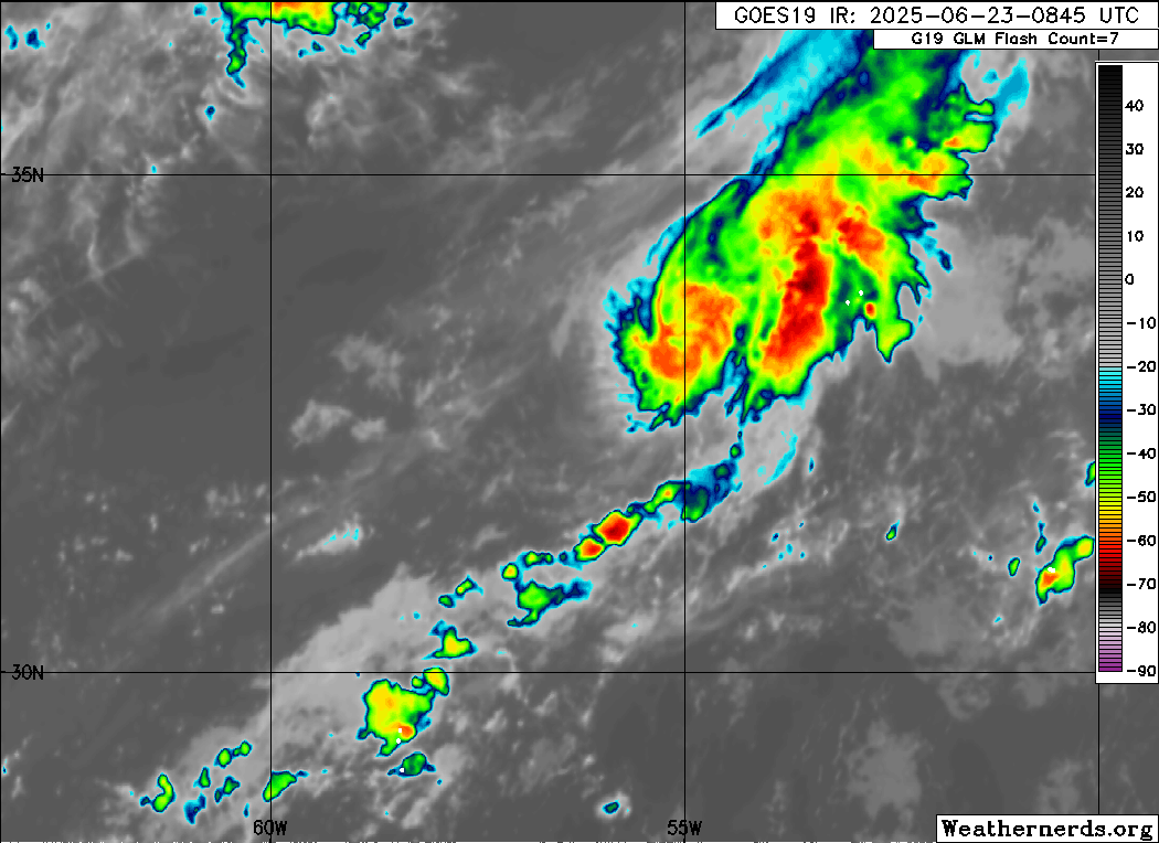
The first storm of the season was not much to write home about, as is often (but not always!) the case with June systems. Andrea formed east of Bermuda almost as a subtropical system as Invest 90L. In the post-season analysis, it was determined that Andrea had already formed into a tropical depression at the time of the satellite loop below.
What had been Invest 90L at the time has been reclassified as a tropical depression. (Weathernerds.org)
While the first advisory on Andrea was not issued until the 24th, it was determined that Andrea actually became a depression on June 23 at 0600z (around 2 AM ET). By 12z, it was a tropical storm, and 30 hours later it had dissipated. Andrea maxed out with winds of 40 mph.
Andrea’s post-season track analysis (NOAA NHC)
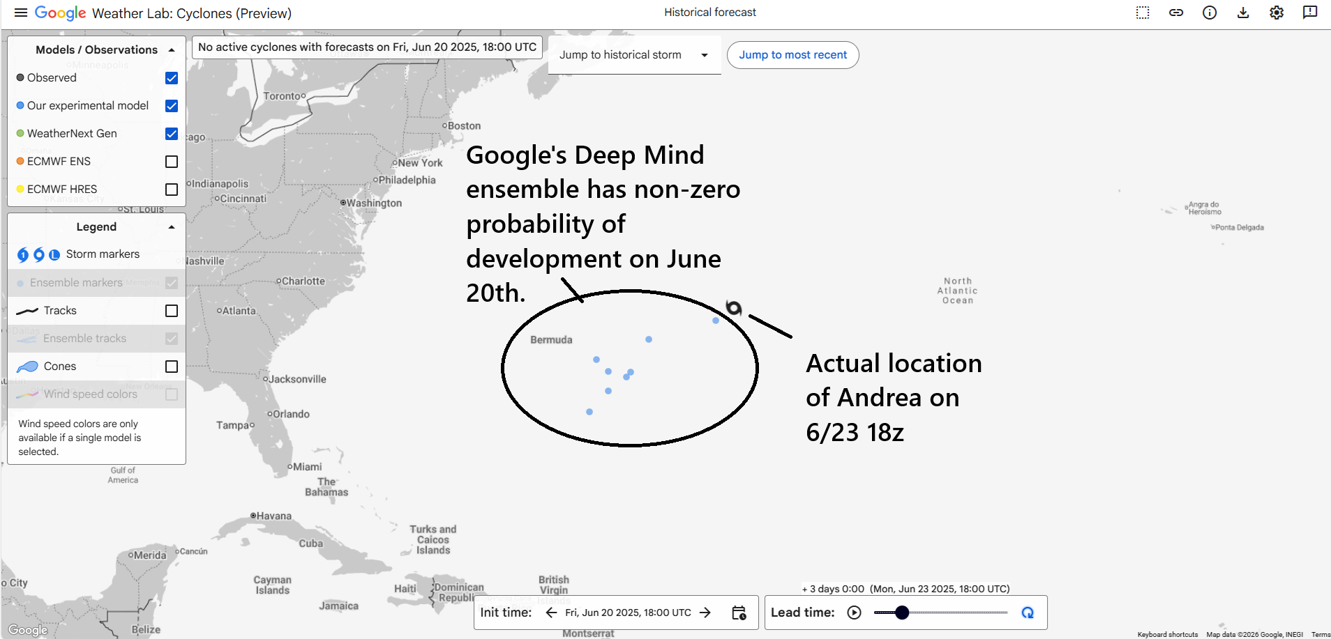
Andrea did not cause any damage, being out at sea and on the lower-end. It’s minimum pressure was a paltry 1014 mb, which is rather high for a tropical storm. No official modeling was done on Andrea, but Google’s Deep Mind model did do an adequate job suggesting low-end potential a couple days prior to development.
(Google Weather Lab)
The first NHC genesis guidance in their daily tropical weather outlook updates had an 18-hour lead time. For an inconsequential, weak storm, the forecast outcomes here and in modeling were tolerable.
Tropical Storm Barry (June 28-30)
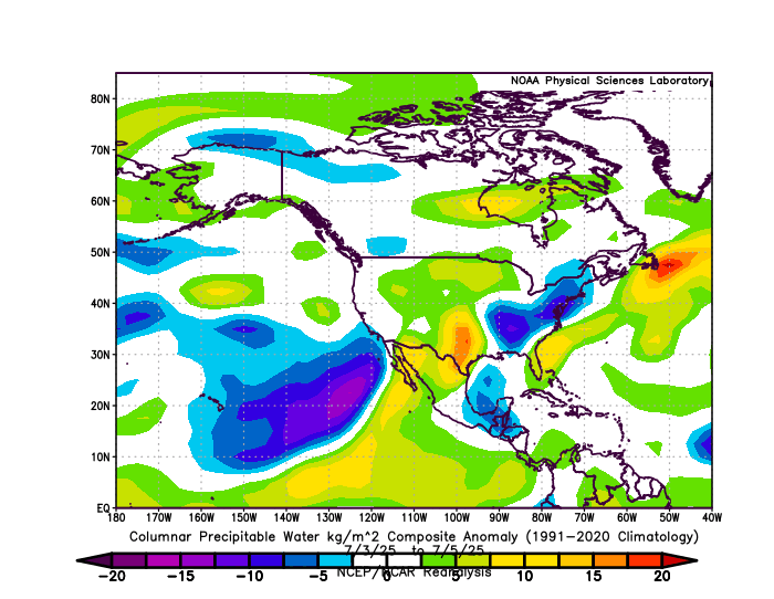
The second storm of the season was another short-lived affair. Barry will likely go down not for what it did but its indirect association with the catastrophic Guadalupe River and Central Texas flooding on July 4th weekend. According to the data provided in the NHC post-storm analysis, it’s clear that Barry was not the primary cause. The overarching pattern that may have helped produce Barry was the primary tropical contributor, of which Barry’s remnants were a slice of. You can see the precipitable water anomaly (or how much above normal atmospheric moisture was) from July 3-5, 2025 below, which shows a really broad trajectory of high moisture funneling into northern Mexico and the Southern Plains/Southwest.
Precipitable water anomalies July 3-5, 2025. (NOAA PSL)
Barry’s remnants were a piece of that puzzle but not the only piece of a complex, tragic event.
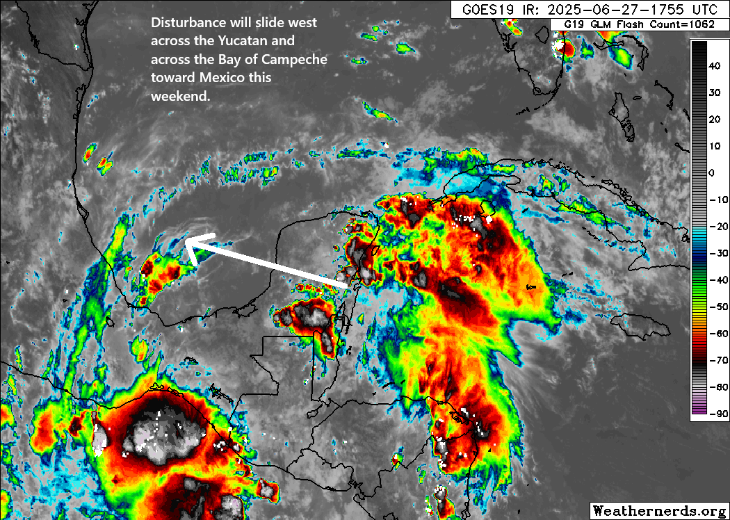
The system itself formed out of a disturbance that by the morning of June 27th was approaching the Yucatan. This was likely on the northern edge of a tropical wave, according to the post-storm analysis.
Before Barry became a storm, it was a pretty rowdy disturbance off the Yucatan. (Weathernerds.org)
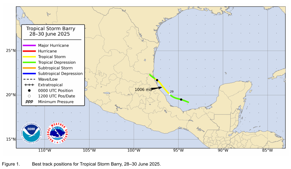
It went on to become classified as a tropical depression in the Bay of Campeche on Saturday the 28th. Barry formed from this the next morning, with maximum sustained winds peaking at 45 mph before it made landfall Sunday evening just south of Tampico, Mexico. In the post-storm analysis, it was determined that Barry had degraded into a tropical depression at landfall, with maximum sustained winds of 35 mph.
Judging from satellite imagery from the storm’s landfall, this was lucky to even be a depression. (Weathernerds.org)
Barry sort of spawned with limited lead time. The first note on the NHC outlook came 42 hours before it formed.
(NOAA/NHC)
Eight people in Mexico died as a direct result of Barry due to flooding or surf, and the storm caused about $5.6 million in damage. The highest reported rainfall from Barry was 17.99 inches (457 mm) at San Gabriel, Tamaulipas in Mexico.
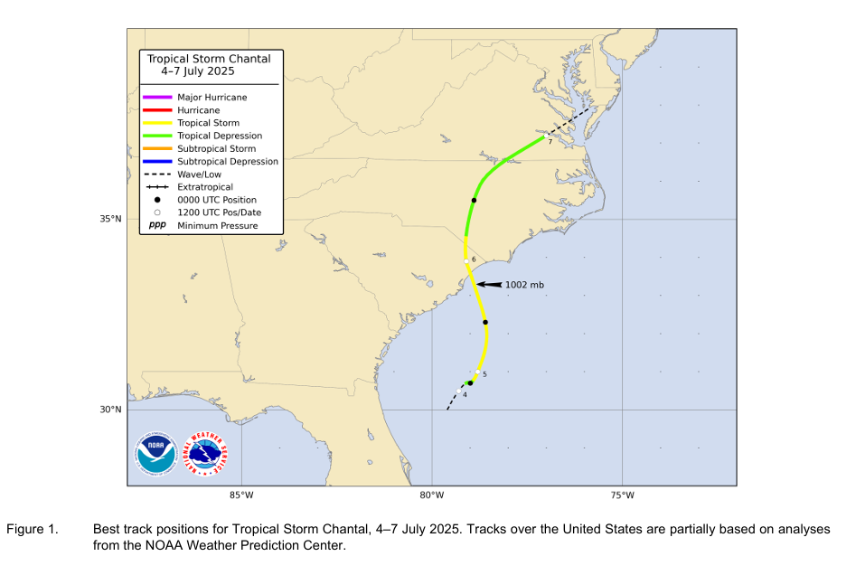
Tropical Storm Chantal (July 4-7)
Unlike Barry, Chantal was snuffed out by weather models several days in advance, with the first note on the NHC’s 7-day outlook happening on June 29th. There we even hints in the modeling several days prior to that, although struggles in the timing of Chantal’s formation led to sort of a last-minute adjustment to probabilities.
June 27th European ensemble forecast tracks in the southwest Atlantic and northeast Gulf for the area that eventually became Chantal. (Weathernerds.org)
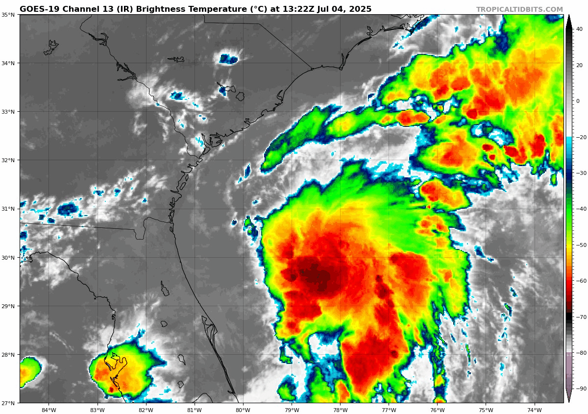
Chantal was an interesting case in that it formed from a dying cold front that stalled out in the northeast Gulf of Mexico and southwest Atlantic. Eventually, the disturbance itself formed in the Gulf and maneuvered into the Atlantic. A depression formed on July 4th from the thunderstorms.
A tropical depression was about to form from thunderstorms off the Southeast coast on the morning of July 4th. (Weathernerds.org)
About 16 hours after that image above, Chantal formed. Chantal began a counterclockwise pivot toward the Southeast coast under the steering currents, peaking at an intensity of 60 mph maximum sustained winds off the coast of Myrtle Beach before coming ashore as a 50 mph tropical storm near Litchfield Beach, SC late in the evening of July 5th. The maximum recorded winds on land were 47 mph sustained, with gusts to 56 mph at Springmaid Pier in Myrtle Beach.
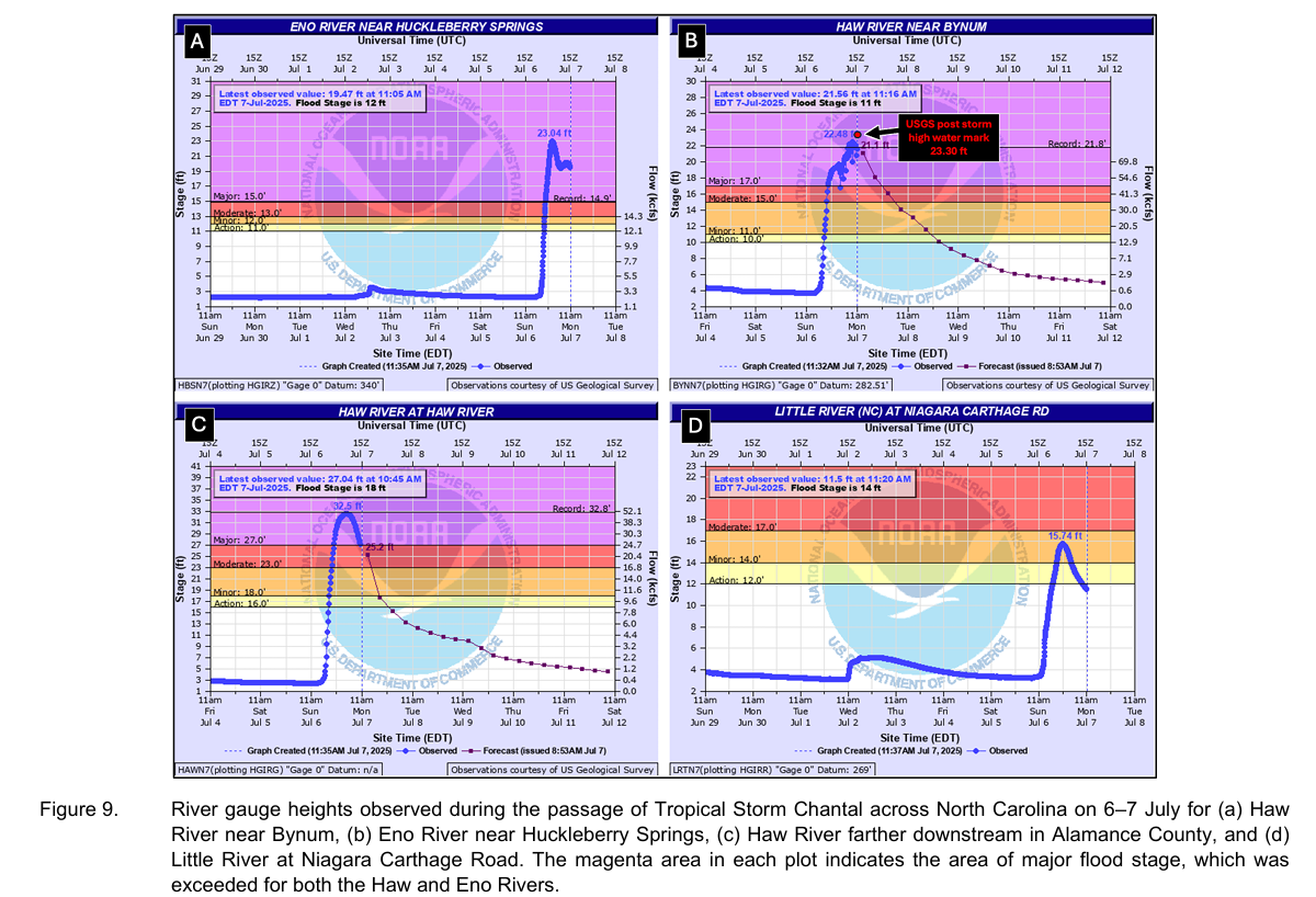
Chantal will go down in the books for the flooding it helped spur in North Carolina. The maximum rainfall reported from the storm was 12.90 inches in Pittsboro, NC, just southwest of the Raleigh-Durham area. This led to record flooding on some rivers systems in the area.
(NOAA/NHC)
Many locations in eastern North Carolina saw 6 to 12 inches of rain, with lesser amounts in South Carolina. Chantal serves as another reminder that the inland flooding risk is sometimes worse than the storm itself.
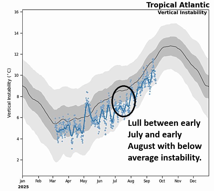
After Chantal, we went about 1 month between storms. Why was that? There was a good bit of atmospheric moisture available. Warm waters were aplenty. There are two theories I have. The first is reduced instability in the Atlantic during that time. In other words, we lacked the “juice” needed to generate thunderstorms, or at least it was below average.
Below average instability likely kept a lid on activity in much of July 2025. (NOAA/Moodys)
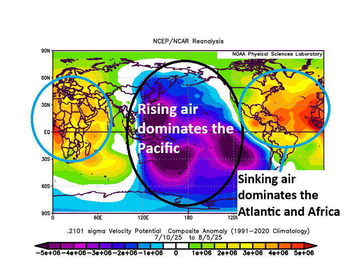
Another reason, which is probably related, is that the background state of the atmosphere over the Atlantic Basin was hostile toward tropical development. If you look at a metric called “velocity potential,” you can see where the background state of the atmosphere shows rising air (better thunderstorm risks) or sinking air (less thunderstorm risk). The average anomaly from July 10 through August 5, 2025 is shown below. Cool colors indicate rising air in the background, warmer colors indicate sinking air.
A lack of rising air likely helped contribute to lower instability and just a generally hostile background state in the Atlantic. (NOAA PSL)
Velocity potential isn’t a make or break parameter. In other words, you can still generate tropical storms even with a hostile background state. But it does tilt the odds such that there may be somewhat less risk during those more hostile periods. Like everything, it’s nuanced. We discussed this a bit around July 10th. This idea seems to have been validated by models overforecasting the return of rising air to the background state of the Atlantic, while simultaneously generating some disturbances in the extended forecast timeframe in July that never actually came to fruition in any meaningful way.
(NOAA/NHC)
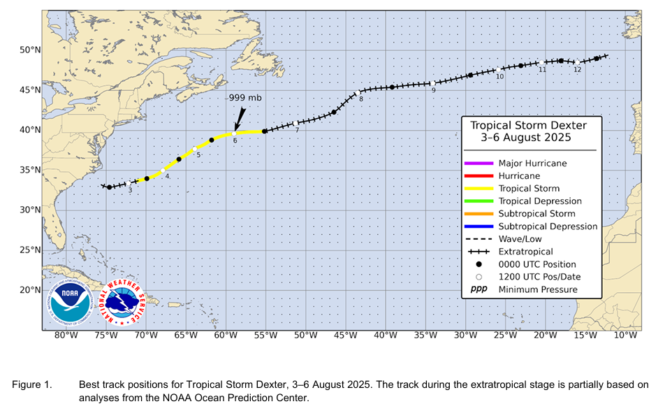
In any event, Dexter formed off a stalled front in the western Atlantic around August 2nd. It became a cyclone about 375 miles west northwest of Bermuda. Dexter peaked on August 6th as a 60 mph tropical storm before becoming an extratropical storm that night. It did reach hurricane-force with winds as an extratropical storm but was not considered a hurricane by definition. Dexter sort of came about fairly quickly with generally mediocre genesis forecasts. But once identified, the models did fine with its forecast.
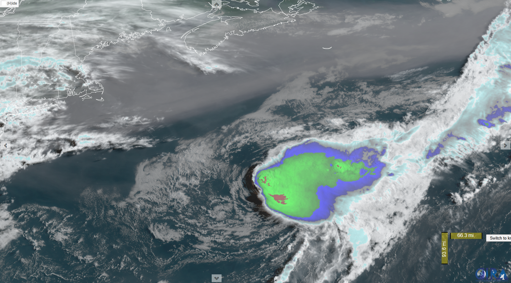
Tropical Storm Dexter moving out to sea. (Colorado State, CIRA)
Dexter was mostly a non-event, as it remained out at sea.
We’ll pick up the action in Part 2 of our season in review.