Headlines
- Hurricane Watch issued from Sargent, TX south to Barra el Mezquital, Mexico, along with a Storm Surge Watch for the Texas coast south of Sargent.
- Beryl forecast tracks on models today have been bouncing all over the place between Houston and Brownsville.
- Beryl now a tropical storm as expected.
- Increasing chance of more meaningful impacts between Corpus Christi and Galveston.
- Uncertainty remains high.
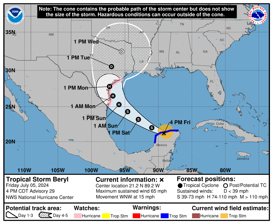
Tropical Storm Beryl (65 mph, WNW 15 mph)
As expected, Beryl transitioned back to a tropical storm today over the Yucatan, but that residence time over land is about to end, with Beryl re-emerging into the Gulf of Mexico tonight.
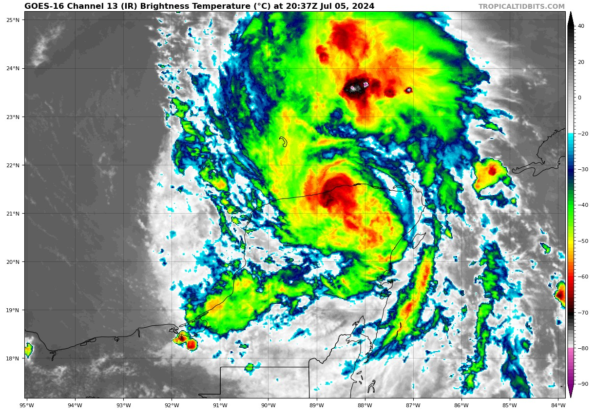
Beryl will need a minute or two to get its bearings once back over water, so it should not immediately intensify. However, the scaffolding remains in place for Beryl to get itself together after 12 to 24 hours over water. From there, it becomes a race against time in terms of intensity. If Beryl struggles a bit in the next 12 to 24 hours, then we’re likely looking at a strong tropical storm or lower-end hurricane at landfall on the Texas coast. If Beryl buttons up quickly tonight and tomorrow, we could see some considerable intensification as it approaches the coast Sunday night and Monday morning. Observations will be critical tonight and tomorrow.
In terms of track, that’s not being helped at all by the intensity conundrum. With Beryl hanging tough throughout its entire life cycle, we have deviated more and more to the north with each run. It will be tempting when all is said and done to say that “Model X nailed Beryl,” but the reality is far more nuanced, and we can litigate that at a later time. Meanwhile, the trends are the trends, and they have been undeniably more to the north and east. How much farther can this go? I honestly don’t know. I would have expected it to stop right now. But we’ve gone from an ensemble mean landfall near northern Mexico yesterday to an ensemble mean landfall near Matagorda Bay on the Euro today. That’s an absolutely massive shift.
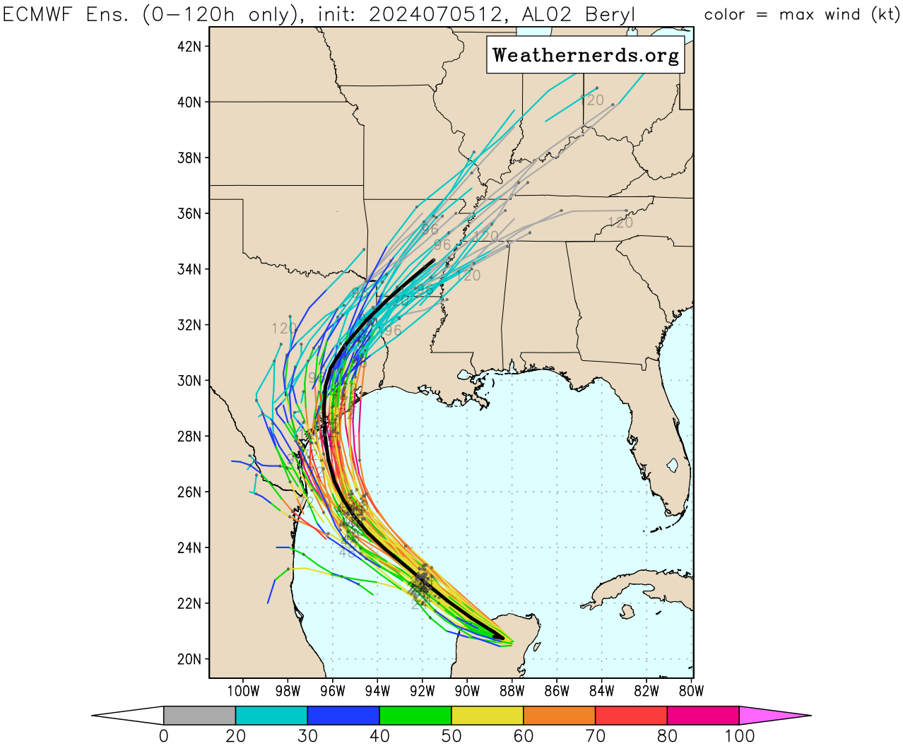
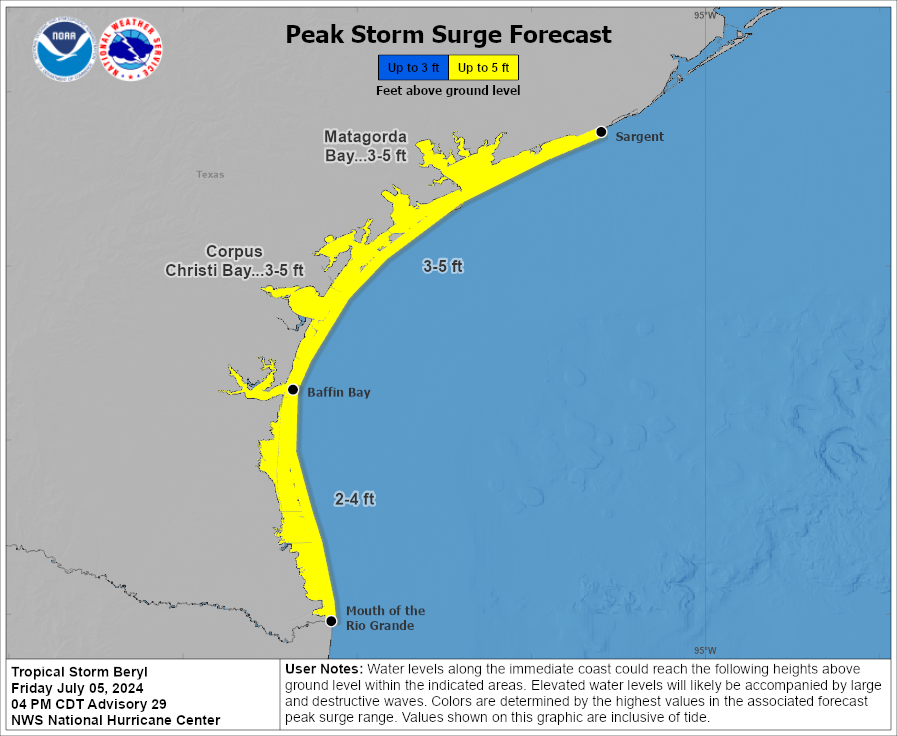
The 51 members above are actually in decent agreement right now with a relatively tight clustering. The problem is that the angle of approach to the Texas coast is such that even a 10-20 mile error can lead to a massive shift in where the storm comes ashore. This is most important for the surge aspect of things. The current surge forecast calls for 3 to 5 feet above ground level for the Texas coast. Expect this to get narrowed and changed a bit on Saturday.
Meanwhile, for folks along the Texas coast, you should be preparing for possible hurricane impacts from Galveston through South Padre Island. It is possible that South Padre can breathe easier later. But for folks in the rest of coastal Texas, it will be critical to monitor forecast changes in the next 12 to 24 hours. Begin making your preparations on the coast, and if you’re south of I-10 in the Houston area, it may be a good idea to prepare for the potential of power outages, something we’ve dealt with more than once this year. For folks from Matagorda Bay through Port Aransas, I would make serious preparations for a full-fledged hurricane impact, stronger than Nicholas in 2021 but not as intense as Harvey in 2017.
The rainfall story remains a tricky one, but Beryl’s forward speed once inland looked a little faster on modeling today which may help alleviate some of the flash flooding risk.
We will plan to update the top of this post this evening if any meaningful changes occur. Otherwise, our next full post will be Saturday morning.
Don’t forget, we are probably on your favorite social network as well.
When do you guys plan to make updates and post?
Thanks for the MOST trusted update….
Thank you for all the updates now and for the remainder of the season!! Greatly appreciated
Your updates are holding our collective sanity together.
I wouldn’t be entirely surprised if Beryl makes landfall as far east as Port Arthur, near the border with Louisiana. At least Houston would be on the dry side of the storm. It all depends on how sharp the curve is and when it’s made.
I don’t understand the mid-level thing that other meteorologists are saying would strengthen Beryl and send it more towards Houston.
Can you give the Dummies version?
Did Ike have a large eastward shift in the last days before landfall? If yes was a similar setup at work?
Thank you! So incredibly grateful to have such responsible and dedicated reporting of the weather. You all make a big difference.
I’m not a meteorologist but it seems like what’s left of the circulation is further north of where the NHC is calling the center. If this is the case the model runs are not initialized well and we’re going to get yet another jump in the models north and east..
Good morning, Matt,
For folks who need to travel in the IH 45 corridor Tuesday, can you please advise whether Beryl’s impacts are likely to peter out near the coast, or if we should expect wind and heavy rain to continue north to DFW?
Thank you for all you do!