First off, I want to just thank folks that found The Eyewall or used The Eyewall during Beryl. We set all sorts of traffic records for our relatively new site, and we’re hopeful that the information offered was useful. I was hoping to post yesterday, but both Eric and myself have had storm damage to contend with and I finally lost internet yesterday. I am fortunate to be on generator power but as you can imagine it’s a little chaotic still.
I just need to clarify something for readers: We have been mostly “dark” since Sunday, which as I noted in our last post was because our coverage was Houston-specific and our companion site, Space City Weather is intended to focus on that. I just want to make it clear to folks so there is no confusion: If a storm is hitting the Houston area, the bulk of our coverage during the storm will be there. We have an obligation to our local audience there. When time allows, we will cross post to the Eyewall. Eric and I juggle a lot of things with full-time work in addition to this, and perhaps one day we can make this our full-time focus. We’ll see.
Beryl initial reaction
For a category 1 hurricane, Beryl was something to go through. It was informative, as this was personally my first hurricane experience. I’ve been in many storms on the East Coast undergoing transition to tropical storms or extratropical storms and many nor’easters, but I had never been in a bonafide hurricane. It is a unique experience. The rapid intensification started a little later than expected as Beryl approached Texas, which may have spared Houston a category 2 or 3 outcome. Still, there is something to be said about a storm rapidly intensifying at landfall versus a stable or weakening storm at landfall. Beryl fell into the former camp and it showed. We’ll probably touch on that another time because I think that further adds to the nuance of hurricanes and shows the pitfalls of using the Saffir Simpson scale monolithically.
In addition to all the power outages and the damage near Houston, a pretty wild tornado outbreak accompanied Beryl in Louisiana and far northeast Texas as well.
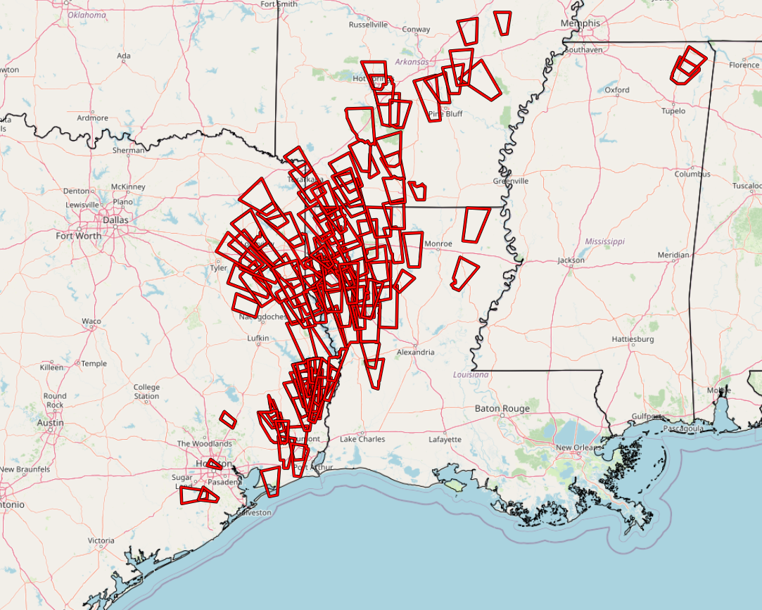
Hats off to the folks, especially at the Shreveport NWS office that issued quite literally dozens of warnings to keep people safe. A special thanks to the utility workers in the field right now trying to restore power to the 1.3 million Houstonians without it still.
It’s a lot to digest, and we’re going to give it a little more time and post more thoughtfully than emotionally about literally all the things involved in Beryl, from the forecast and modeling to the impacts to the nuance to Houston-centric questions about preparedness, sustainability, and resiliency.
Beryl’s rain & Southeast shenanigans
Beryl’s remnants are into the Midwest and Northeast today, and there is a moderate risk of excessive rainfall in place for parts of Upstate New York, the Adirondacks, and Vermont. Flash flooding will be possible as that comes north.
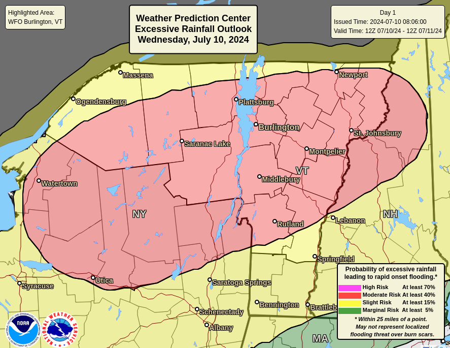
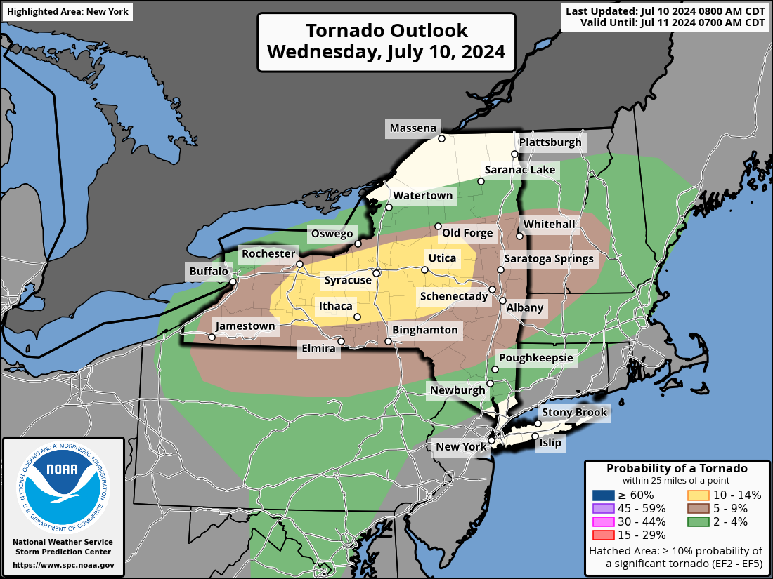
This includes Utica, Watertown, Burlington, and Montpelier, some areas that have seen serious, devastating rainfall in recent years, so hopefully problems aren’t as serious this time. In addition to excessive rain, there is an enhanced tornado risk today (level 3/5) for similar areas, including much of Central New York. Have a way to receive weather warnings in this area.
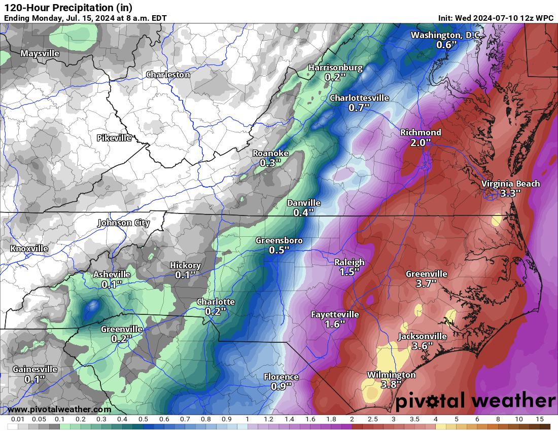
Meanwhile, the Southeast will be keeping tabs on a weak low pressure system off the coast to close this week. It is not quite together yet, but over the next 2 to 3 days, modeling suggests it organizes a little, tracks along or just off the coast of the Carolinas and eventually out to sea. The good news is that any development should be slow to occur and this will be out of the picture in a couple days. The Hurricane Center has 10 percent odds on it. I might lean a little higher than that, but the ceiling is low on this one. There will be locally heavy rainfall however, and a slight risk (level 2 of 4) of excessive rainfall is in place on Friday as this exits.
Other than this, no areas of development are noted by the National Hurricane Center today.
Looking out farther in time, the background state of the atmosphere over the tropical Atlantic looks highly unfavorable for tropical development. Modeling is pretty quiet overall with not even many outlier members showing tropical development over the next 10 to 12 days. I think we will close July on a quiet note, given this, with perhaps maybe a slight uptick of risk in just the last few days of the month or early August. But for those of you with plans over the next week or two, we see no concerns for now.
We love you guys!!! Apologies to anyone in Beryl’s leftovers. We tried to kill her but she fought hard!!
How much of a “dent” in the warm water energy pool in the Gulf did Beryl cause? Insignificant? Can’t tell yet?
Is there a site up yet that shows Beryl’s actual eyewall path through Houston? It would be interesting to see how close we actually were here.
Awesome coverage.
Where can I find stats on the storm? i.e. wind gusts, rainfall, sustained wind for the greater Houston area.
Thank you so much for your expertise and ability to accurately explain complicated science on a layman’s level. My family relied on your sites these past few weeks. I have experienced numerous storms in the Houston area and Beryl was worse/different than any normal cat 1. It will be interesting to learn more from it as time allows.
God bless you guys and your families.
Thank you so much for your sane coverage!!!
Friendswood resident here, a suburb of Houston on the southeast side toward Galveston.
Beryl was not like any Cat 1 I’ve been through, and I’ve lived on the Gulf Coast my whole life. I grew up in Baton Rouge, LA and remember Andrew in 1992, Katrina in 2005, (of course) and Gustav in 2008. Where we lived we had the eye pass over us during both Andrew and Gustav, and neither storm was as strong of an experience as Beryl. I’m reaching a bit on Andrew since it was over 30 years ago, but IIRC it made landfall as a Cat 3 (after leaving a path of destruction across the Florida peninsula) and I certainly remember Gustav made landfall as a Cat 3. (Katrina isn’t a good comparison since we were on the clean side.) There is certainly a BIG difference between a storm that’s strengthening as it makes landfall like Beryl, and one that’s weakening, like Andrew and Gustav. I don’t know how much real-time data is available out there but I truly wonder if Beryl continued strengthening even as the eyewall was on land, like it was feeding on its own moisture.
I know it’s just a seat-of-the-pants assessment, but I wonder if there is data out there that may back up
I was thinking the same thing. I’ve ridden out plenty of hurricanes and Beryl was like a supercharged ‘1’. Like the internal physics inside the winds were somehow themselves stronger, at the molecular level.
I’ve watched tropical storms come in with my feet on the window sill and a book in my lap. Loved the feel of them.
Those days are over.
I spent 5 years following Space City Weather as I was on construction projects at Willis, Pasadena and Port of Houston. I still follow your blogs but I have returned home to Florida. As soon as you inaugurated The Eyewall, I was thrilled to get on board. Your honest assessments and non-dramatic posts are truly refreshing. This is the first time I have ever commented but I wanted you to know that you and Eric are appreciated. Thank you.
As a Floridian I want to thank you for all the great work you do! And I hope your power is restored quickly!!
Well done, Gentlemen. As a Rockport resident, I followed your posts studiously. I hope you haven’t too much damage. Keep up the No Hype format. You have a growing audience down here in the Coastal Bend.
As a newbie look up Hurricanes Carla or Alicia. You’ll be alarmed as to what the insured and uninsured losses could have been from a more powerful storm. And also the few lessons learned by those responsible for our infrastructure. At least we’re number 1! According to Bloomberg Texas leads the nation in the number of $1B+ losses since 1980. More than California or Florida.
if i didnt know beforehand what category this storm was, i would have guessed 2 or 3. it definitely packed more of a punch than i was expecting. not sure if that was something to do with the storm itself or merely being on the dirtier side of things. glad it was moving quickly. another couple hours of those gusts would have not been good. i can still hear the gusts lol, kind of nightmare fuel. i couldnt sleep, was up as the storm was approaching around 3am
I’ve lived through Alicia, Ike, and Harvey. The destruction of this storm in our northeast forested neighborhoods was every bit as bad as those. I’m wondering why we lost SO MANY TREES if the winds were only Cat 1 speed….drought effects? disease? higher temps in recent years causing drier trees that can snap more quickly?
I so appreciate all that ya’ll do for Houston (and now spreading north and east). I’ve become a weather nerd over the years and love studying your breakdowns.
P.S. Welcome to Gulf Hurricane Central! This was just a warmup so get prepared! Houston loves you!
Could you please talk about why there was so little thunder and lightning?
Thank you for your insightful newsletter.
Thank you for your dedication to our Houston community. The Eyewall publication was recommended to us by our daughter. Great work!
Bless you both for all your work, especially with all the storm damage that you yourselves are dealing with!!! You guys are great, the best and most accurate forecasters around, and full of good humour as well. Thank you!!