Headlines
- Beryl will weaken as it moves across the Yucatan today, emerging as a tropical storm tonight in the Gulf.
- Beryl will steadily re-intensify as it comes west across the Gulf.
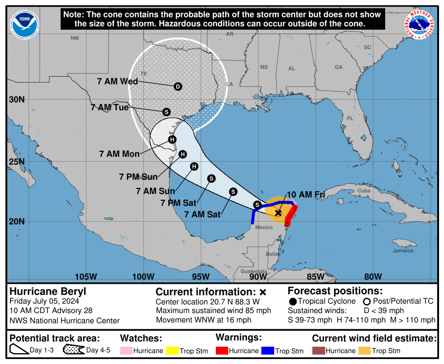
- Forecasts have shifted north since yesterday and a landfall as a hurricane on the Texas coast north of South Padre Island is likely Sunday night or Monday, with risks as far north as Matagorda Bay.
- Impacts will include wind, surge, heavy rain and flooding, as well as isolated tornadoes, especially near and north of exactly where Beryl makes landfall.
- Preparations should be in full swing on the Lower & Middle Texas Coasts. Matagorda Bay should keep a close eye on this. Coastal residents in Houston/Galveston should prepare for tidal flooding again.
- We’ll have another post later today.
Hurricane Beryl (< 100 mph, WNW 15 mph)
Beryl made landfall this morning on the Yucatan Peninsula of Mexico just northeast of Tulum. It is now inland over the Yucatan and has lost its primary fuel for intensification, the warm Caribbean. Beryl will steadily weaken over land today and is expected to come off the Yucatan as a tropical storm tonight.
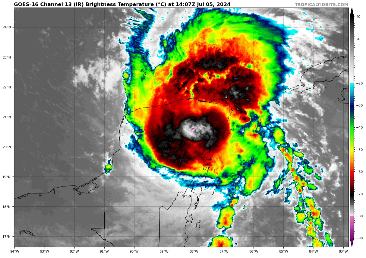
Despite weakening to a tropical storm, it is likely that Beryl will not be starting from scratch once in the Gulf. Its core should remain fairly in tact, and it will not take much to allow it to begin to feel the warm Gulf waters again and begin re-intensifying as it comes west northwest.
Beryl’s future track
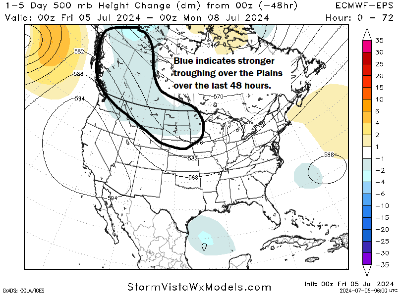
Beryl is going to be walking an absolute tightrope over the next 2 days. I say that for residents of Texas, because as Beryl turns, exactly where that turn occurs will have an outsized impact on who sees exactly what. For now, I think the key player is this trough over the Plains. Over the last 48 hours, models have tended to further strengthen the trough. That coupled with a slightly farther north track of Beryl has led to Beryl being able to “feel” the tug of this trough more, which is forcing Beryl to come a little more to the north when it gets into the western Gulf of Mexico.
So what exactly does this mean for Beryl’s forecast track? When you look at the 51 member European ensemble now, you can see that the majority of the members are turning Beryl northwest or even north northwest into Texas.
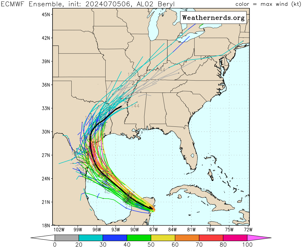
The problem is two-fold. First, where exactly does that turn to the north northwest occur? That will determine the landfall point on the Texas coast. Secondly, that landfall point will have tremendous impact on who sees what. A landfall in Matagorda Bay means the southwest suburbs of Houston could experience a full fledged tropical storm type outcome, whereas Corpus Christi would be pretty much fine. A landfall in Baffin Bay south of Corpus would likely deliver hurricane impacts to Corpus Christi and few impacts to Houston beyond thunderstorms and rain. Storms approaching at an angle, rather than more perpendicular to the coast provide a world of problems from communicating impacts. Literally a 15 mile change in the angle of approach can add or remove entire counties from certain expected impacts. My hope is that we’ll get some additional color on this by afternoon, and we will have another update this evening with the information.
How strong will Beryl get?
Beryl’s intensity will be contingent, somewhat, on what it looks like coming off the Yucatan. Assuming some organization still, as well as tropical storm status should allow it to begin to quickly re-intensify. The waters of the Gulf, or the oceanic heat content available to Beryl is not inconsequential, but it’s also not the Caribbean rocket fuel that it had on the other side of the Yucatan.
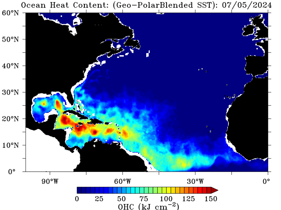
Still, this argues for steady intensification as Beryl comes toward the Gulf. Water temperatures immediately adjacent to the Texas coast are quite warm, so Beryl will not weaken on approach and should make landfall as a strengthening storm. Most modeling keeps Beryl as a tropical storm or a low-end hurricane as it comes ashore. The NHC forecast is slightly more aggressive than this, which is a stance I wholeheartedly agree with. I would plan for a borderline category 2 storm at landfall and hope for the best. The radius of hurricane force winds is currently only 30 miles out from the center, so Beryl is a relatively small storm. Do not focus on the intensity of Beryl other than if you live along the immediate coast, as this will likely deliver tropical storm wind impacts to most. However, widespread tropical storm winds and localized hurricane winds will still cause power outages and damage and should be respected.
In addition, while we don’t currently have a storm surge forecast, it is safe to assume that Beryl will deliver a surge and coastal flooding between Corpus Christi and Cameron Parish, LA. We will have more details on this to come, but expect something similar to Alberto’s impact last month, with pockets of worse conditions near and to the north of where the center comes ashore.
Beryl also a heavy rain and flooding concern
In addition to the hurricane impacts we normally see, Beryl will be a heavy rain producer for Texas. The current rainfall forecast is calling for locally 6 to 8 inches of rainfall, but I fully anticipate that this forecast will be upgraded some before all is said and done. Double digit rainfall totals are likely in a few spots with the most persistent rainfall and localized flash flooding is going to be a concern.
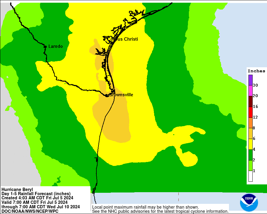
Beryl will not stall, so I want to make clear for folks in Texas that this is not a Harvey redux. However, Beryl will move slowly once ashore. Even relatively more progressive and faster models like the GFS dump up to 10 inches in spots. So the heavy rain concern is there. Expect more color on this later today as well.
The bottom line?
For folks in the Rio Grande Valley: If you live in a flood prone area, keep an eye on the rainfall forecast for Beryl. Wind impacts will likely be confined to Brownsville and the coast.
For folks on the Lower and Middle Texas Coast and Coastal Bend region, including Corpus Christi: Prepare as if a hurricane is coming and make sure to follow local officials guidance in terms of evacuation if needed.
For folks in the Matagorda Bay area: Start making preparations in case the forecast shifts to the north and brings hurricane conditions closer to the area.
For folks in the Houston area: Continue to monitor trends today and tomorrow. Make whatever preps you feel comfortable making or you feel are warranted. Current forecasts keep most meaningful impacts beyond localized flash flooding away from us. Coastal residents prepare for at least minor to moderate tidal flooding.
We will have another update late this afternoon.
Hi Matt. I’m a follower of your site from Lumberton Texas. What’s the outlook for Beaumont, Lumberton area? I was planning on taking vacation out to west Texas, leaving Sunday. Thanks. Enjoy your site.
For now you’re comfortable east of anything other than some storms and localized flash flooding. Keep tabs on it, but I would think you can still take your vacation.
Thanks!
Wow. Thanks for the update! You guys deserve every award in the industry!
I second Jeff’s comment- you guys are the only place we look for weather and updates! Thank you do much
We’re supposed to be driving from Alabama back to Houston on Tuesday…should we delay or reroute? Driving I-10 in torrential rain sucks.
Thanks for the detailed update Matt. Time to just wait and see what this storm does.
By Houston coastal cities do you mean lake Jackson, Freeport area?
Bolivar to Surfside.
Okay thank you!
Thank you for all the work you do keeping us updated.
Would you have any idea about flight impacts in Houston on Wednesday?
I’m new to the Rosenberg/Richmond area. Do I take my warnings with matagorda or Houston? I’m in between both it seems and I’m lost as what to consider are my warnings. Thanks for all you do!
You are way closer to Houston than Matagorda. I would say Houston.
If Beryl strikes the coast near Matagorda Bay, the Richmond-Rosenberg area likely will get stronger winds and greater rainfall than Houston since Fort Bend County is closer to the coast than most of Houston (except for Clear Lake area). Any landfall southwest of Houston, such as Matagorda Bay, puts Harris, Fort Bend, Brazoria, and Galveston counties on the “dirty” (bad) side of the tropical storm. I suggest you keep reading The Eyewall and pay attention to updates.
Just want to say as fellow person who studied weather at Pennstate living in Houston you guys do great work!
Thank you Matt!
Thanks. SPI beach bum.
Hi, Matt! I appreciate your common sense information so much. I have a flight out of Hobby scheduled for Tuesday at 4:00 pm. I live in Lake Jackson. Do you think all this will have passed then? I’m keeping tabs on Southwest’s weather advisories, but I’m interested in your thoughts regarding air travel on Tuesday. Thanks!
The view from satellite looks like what’s left of the eye is about to exit the Yucatan on the north side of guidance. Which probably means the cone of death with be moving east…
What is a “15 mile change in the angle of approach?” Do you mean 15 degree change in the angle?
As a noobie with The Eyewall, and as a resident of the Rio Grande Valley, thanx! It is great reading localize information, especially about the Valley.