Headlines
- Beryl is expected to become a hurricane as it moves into the Windward Islands Sunday night and Monday.
- Beryl has the potential to become a major hurricane as it moves into the Caribbean, feasting on water more typical of August or September than June or July.
- Hurricane impacts are likely for Barbados and the islands south of Martinique.
- Interests in Jamaica, southern Hispaniola, and the rest of the western Caribbean should monitor Beryl’s progress closely.
- It is simply too soon to say anything coherently about the U.S. Gulf Coast or Mexico impacts from Beryl, if any at all.
- Invest 94L will bring heavy rain to Mexico, while a wave behind Beryl has a 60 percent chance of slowly developing next week.
Tropical Storm Beryl
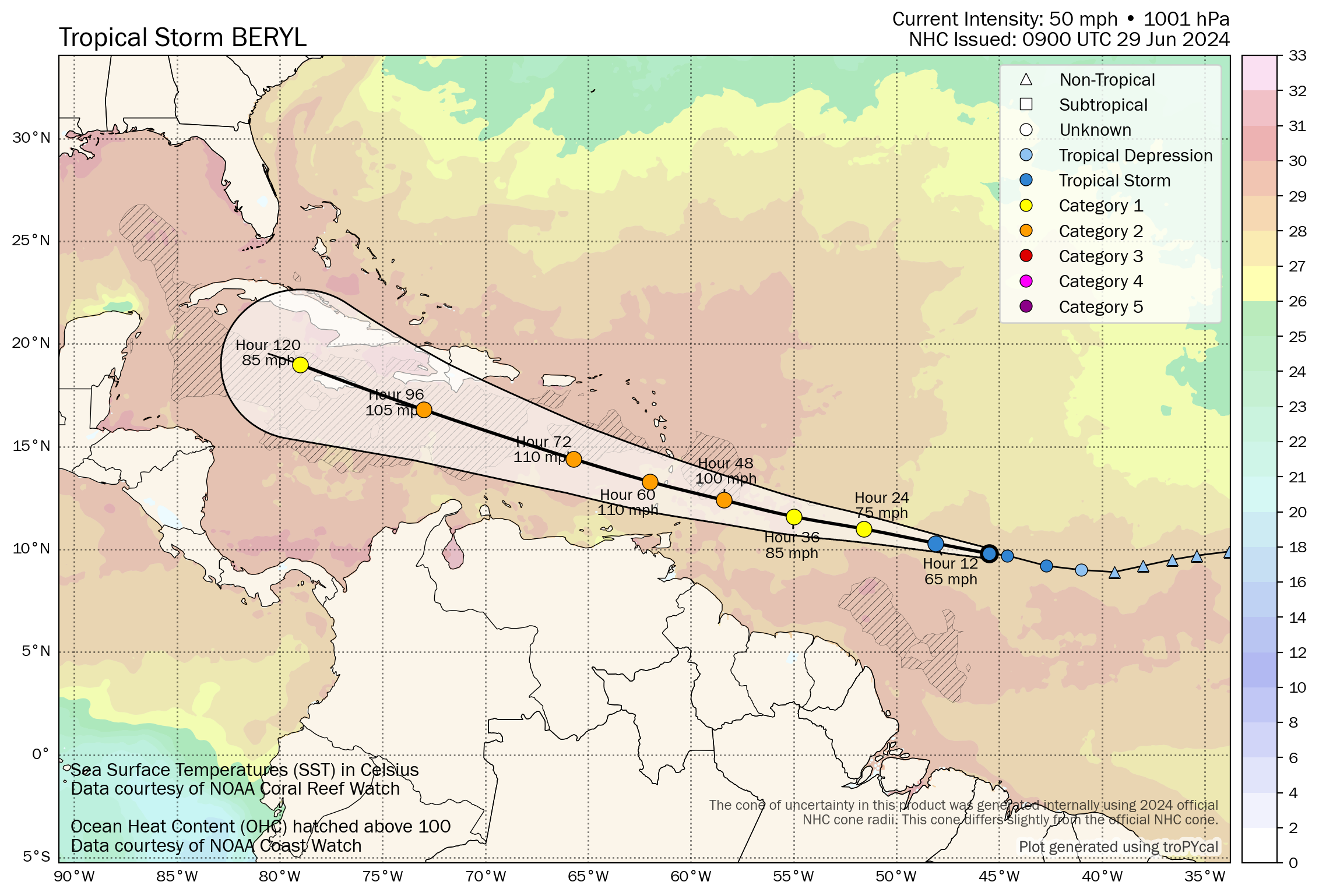
As expected, Invest 95L became a depression and is now Tropical Storm Beryl. It is expected to become a hurricane as it moves through the Windward Islands and into the Caribbean by Monday. From there, confidence in track decreases a good bit and interests in the western Caribbean, including Jamaica should monitor Beryl’s progress over the next few days.
Beryl’s intensity
A look at Beryl on satellite this morning shows a rather robust system that’s working hard to get organized.
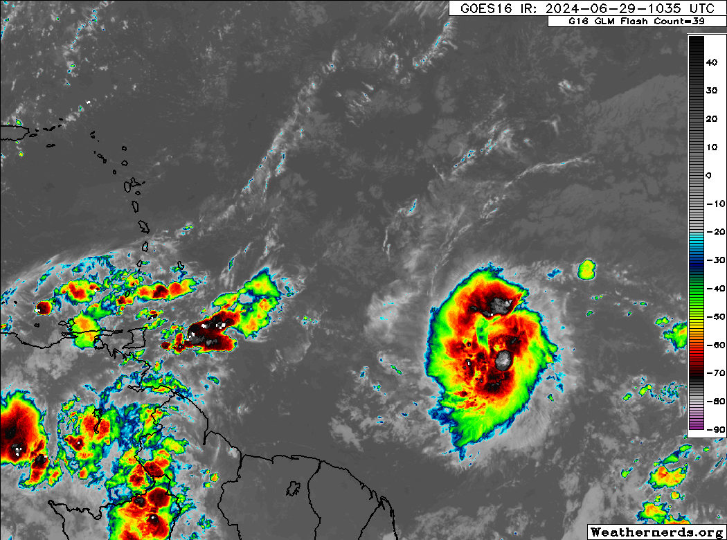
The center is still skewed to the eastern half of the thunderstorm activity, meaning it’s not quite *well* organized yet. But it’s trending in that direction. Look for Beryl to become a more buttoned up tropical storm later today.
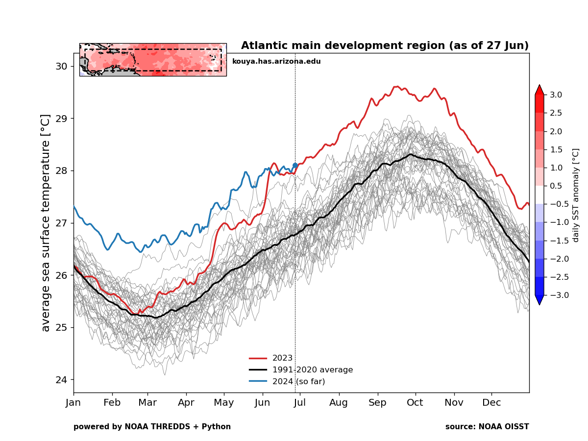
From here, we have almost unanimous model agreement that Beryl will strengthen as it comes west toward the Windward Islands. It arrives in about 48 hours, and the model probabilities of strong intensification are extremely high. Right now SHIPS guidance, which we use as a guide for potential rapid intensification is running anywhere from 5 to 13 times higher than climatology over various periods and intensities. The National Hurricane Center describes Beryl’s environment as “abnormally favorable” for intensification. This is precisely what we were concerned about coming into this hurricane season, as water temperatures in the Atlantic Main Development Region are at record levels. They’re at records in the Caribbean too. Beryl is in an environment that’s more August than June.
The official NHC forecast brings Beryl to higher end Category 2 intensity by the time it cuts across the Windward Islands and into the Caribbean, and there is legitimate risk that this forecast is too conservative. A major hurricane may be possible near Barbados or as Beryl inches into the Caribbean. If you’re wondering, only 13 Category 2 or stronger hurricanes have passed within 100 nautical miles of Barbados historically, all of which have occurred in August or later. We’re in uncharted territory.
As Beryl works into the Caribbean, it will hit a bit of a crossroads. If the storm really intensifies beyond forecasts, it could be drawn north closer to Jamaica or Cuba and run into land issues that weaken the storm. If Beryl is impacted by wind shear, as is often the story in the Caribbean, it will likely stabilize or even weaken some as it comes west. That is what is explicitly shown in the NHC forecast, with Beryl dropping to category 1 intensity again by Wednesday night.
All that said, I would not necessarily be counting on Beryl to weaken at this point, and as the NHC even notes, people should not be focused on the specific intensity numbers. The near term concern is folks in the Windward Islands preparing for a borderline major hurricane impact, while folks downstream in Jamaica or the Caymans or even Hispaniola should monitor Beryl’s progress closely.
Beryl’s track
As noted above, a lot of Beryl’s track may depend on its intensity, with a stronger storm “feeling” troughing near Bermuda and being tugged northward, while a weaker or more disorganized storm may track more westerly or west-northwesterly across the Caribbean.
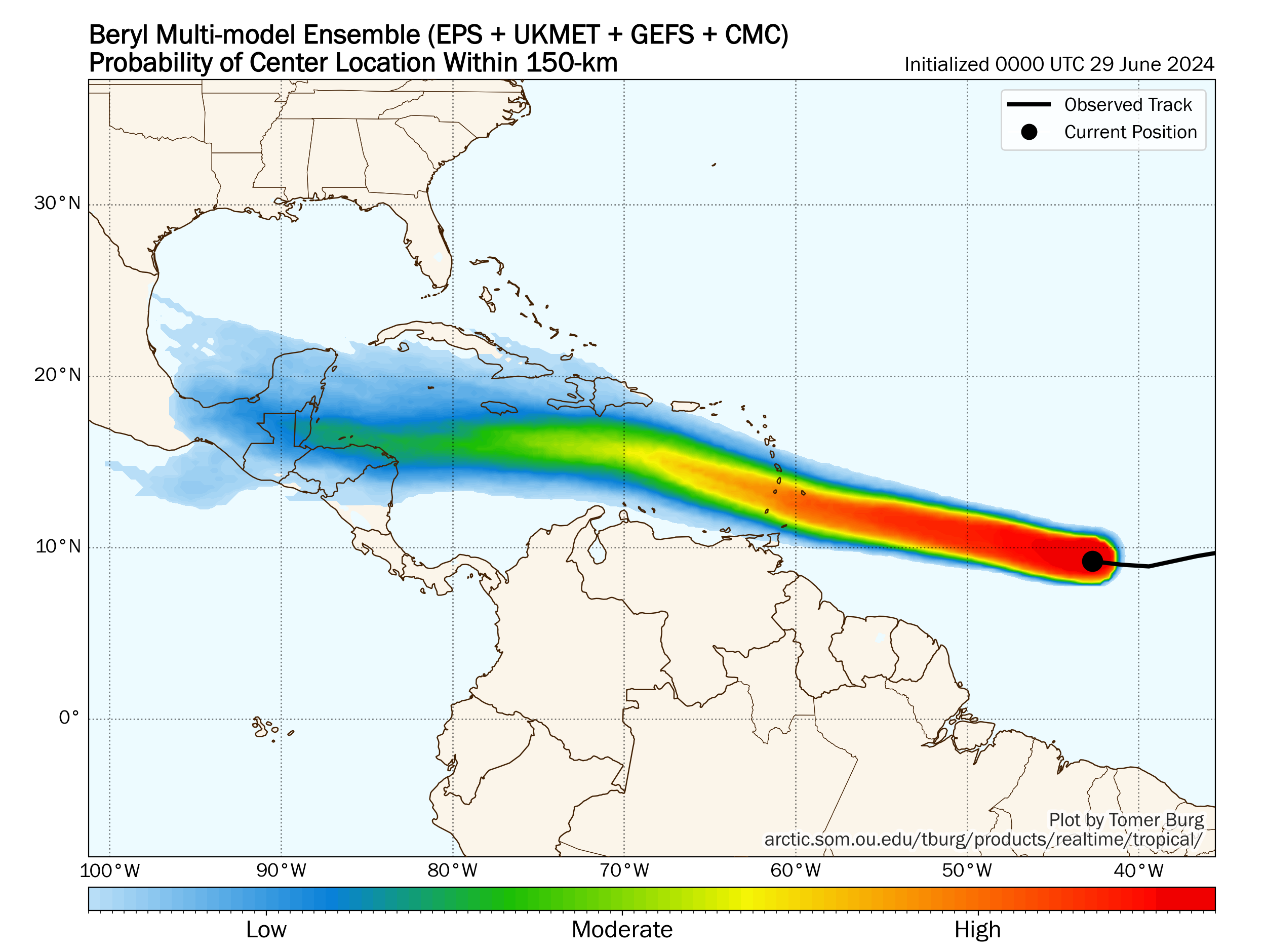
The map above shows the probability of Beryl’s track being within 150 km of a given point. You can see that model agreement is extremely strong as Beryl passes the Windward Islands. Once it gets into the Caribbean, confidence diminishes a good bit until it drops to low confidence in the western Caribbean. But I think it’s obvious that tracks toward southern Hispaniola, Jamaica, and elsewhere are very much on the table, and the current forecast cone from the NHC captures this very well.
For folks on the U.S. Gulf Coast or in Mexico and the Yucatan, it’s simply too soon to really say a lot about this. There’s no real signal in the noise that we can meaningfully derive from the current model guidance. Yes, it seems a track to the south of the Gulf is generally favored right now, but there is a high degree of uncertainty beyond day 5 on where this goes, in addition to the uncertainty on its intensity. Keep monitoring for now, but we’re still a few days from being able to say something coherently.
Beryl’s impacts
For the Windward Islands, Beryl clearly looks as if it will be a noteworthy storm in terms of wind speed, with again only 13 previous category 2 or stronger storms in that region since the 1800s. A hurricane watch is posted for Barbados, and additional watches or warnings will be handed out later today.
A look at the HWRF model as it moves into the Windward Islands (don’t focus on specifics here) shows a relatively compact storm.
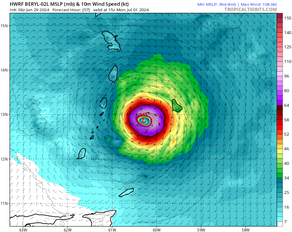
Hurricane-force winds are not forecast to extend out terribly far from the center, but tropical storm-force winds (damaging winds) would be implied to extend from Martinique south toward probably Grenada. With that said, any shift in track could easily change the outcome on a given island. So basically, the Windward Islands should all be preparing for a hurricane impact.
Beryl will also produce heavy rainfall on its path.
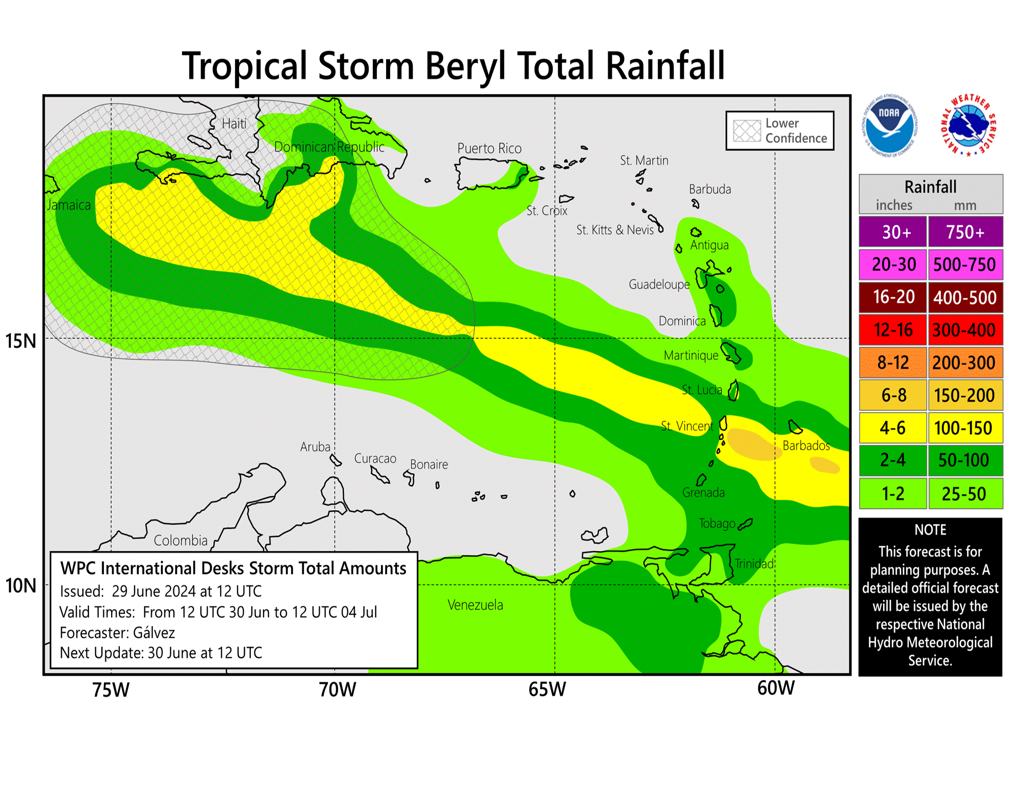
Rain totals should peak near Barbados, St. Vincent, or St. Lucia with about 6 to 8 inches total. Higher amounts are possible. Flooding and mudslides will be a concern but perhaps mitigated somewhat by Beryl’s forward speed. Waves and rough seas will also be an obvious issue with Beryl as it moves into the Caribbean.
Bottom line on Beryl: A storm more typical of August or later will impact the Windward Islands by Monday, and those regions should prepare for hurricane impacts. Areas in the rest of the central or western Caribbean should monitor Beryl’s progress closely in the coming days.
Other systems of note
Invest 94L flared up yesterday in the northwest Caribbean. It’s currently over land, but it will have a brief window to perhaps make a go at organization before moving inland in Mexico early next week. Heavy rain and flooding are the main concerns with this.
We’ll continue to watch the wave behind Beryl, which now has a 60 percent chance of developing into a tropical system next week. In DJ Khaled parlance, another one.
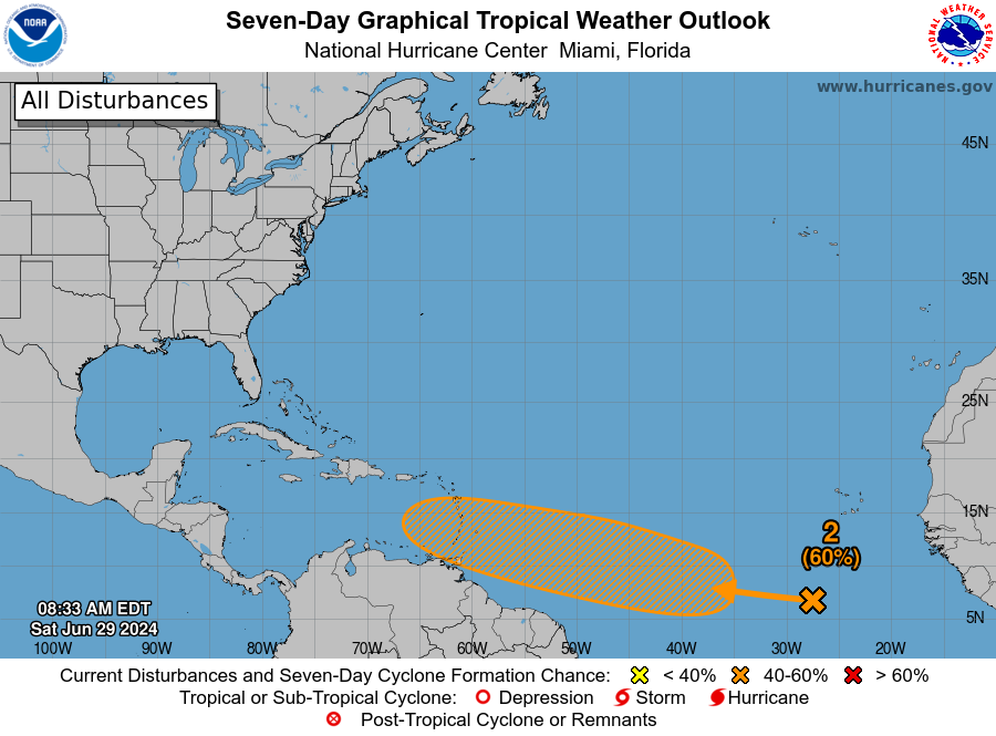
This wave will likely follow Beryl into the Caribbean, though currently the models suggest it will have less upside than Beryl in terms of intensity. Thus, one might expect this stays in the southern Caribbean tracking west or west-northwest. Still, we’re several days out, so we’ll keep monitoring.
Shouldn’t the high pressure system over the SE US deter or interfere with Beryl enough to keep it S of the US or keep Beryl a lower end storm if it were to get to the Western Gulf?
In theory, yes. But in reality, there are signs that may weaken by next weekend, around the time Beryl would be near the Yucatan, so I wouldn’t be super confident in that being the case. That said, yes, my base case now (personally) would hold it south of the Gulf Coast. But it’s low confidence thinking.
I just arrived in the Cayman Islands. Supposed to flight back to Houston on July 4.
I’m guessing I should try to get out of here on Wednesday or even Tuesday?
I would have some plans ready to go if things change. For now, just watch how it goes and monitor the forecast. I wouldn’t pull the trigger on a decision til tomorrow at the earliest or Monday.
The NHC said something about a ridge forming to the northwest later in its track. Could that keep it away from the upper Texas coast?
That will be the case later this week, but by the weekend, the pattern may change somewhat. So while I would agree it stays south probably, I can’t confidently rule the Gulf Coast out right now.
It would be interesting to note, in comparison, which forecasts are physic based versus AI based.
All of the forecasts shown here are either dynamic or statistical models. These are traditional physics based models. If you are curious, the European AI (AIFS) model is on the far southern fringe of the forecast envelope, taking it into Central America. We will make clear if a model shown is AI.
Question about MDR temps. Your chart shows about 1.5 degree above normal. On tropical tidbits ocean analysis page the current difference is shown as .502 degree warmer(specifically for the Atlantic MDR). Are there different methods for these measurements or is one site simply incorrect?
I think it has to do with how the MDR is defined by the creator. I think there can be some nuance to that, as well as what data source they’re using. The one I show here is using NOAA OISST based on 1991-2020 climatology. I believe Levi’s is using another data set (CFSR) based on 1981-2010 climo. I can’t speak to the exact differences, but I would assume that if you looked at them normalized they’d be similar…it’s just a function of what data you’re using.
If this June is now looking like past August/September, I am not looking forward to the new standard for this August/September. Many thanks for the analysis and updates.
Just renewed the windstorm insurance this past week.
I don’t like the way this is tracking, even this far out, appears headed to the Gulf. My gut feeling says probably as a hurricane, about a week from now eyeing either Mexico, TX, or Louisiana.
Assuming it gets into the Gulf, will it encounter conditions causing to grow stronger? Did Rita and/or Ike travel around high pressure ridges such as the one that will influence Beryl?
Now a hurricane.
A cat 4 no less.
We have plans to charter a boat around the BVI on the 1st to the 9th. Should we bail ( Tortola, Virgin Gorda, etc)?
BVI look fine right now.