Happy Independence Day to our readers here in the U.S. Hope it is a safe, fun day and/or weekend for you.
Headlines
- Hurricane Beryl is motoring toward the Yucatan, with landfall expected late tonight or Friday morning near or north of Tulum.
- Beryl’s forecast toward the western Gulf is coming into slow focus now with a landfall likely well north of Tampico, Mexico and south of Port O’Connor, TX.
- Hurricane impacts are possible to likely in South Texas Sunday into early Monday.
- Beryl will transition into a heavy rainmaker once inland with increasing chances of excessive rain in South Texas showing up now.
Hurricane Beryl (115 mph, WNW 18 mph)
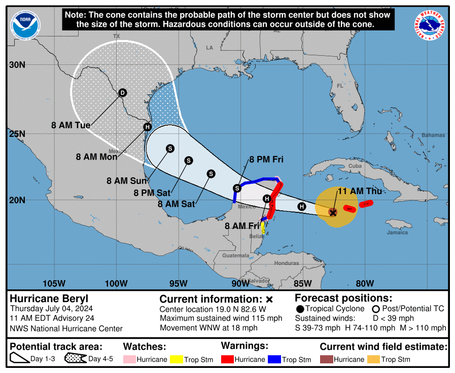
Beryl made a very close pass on Jamaica yesterday evening, and is now back out in the Caribbean chugging west northwest toward the Yucatan.
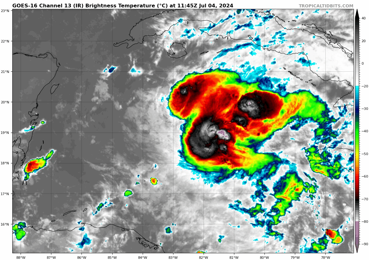
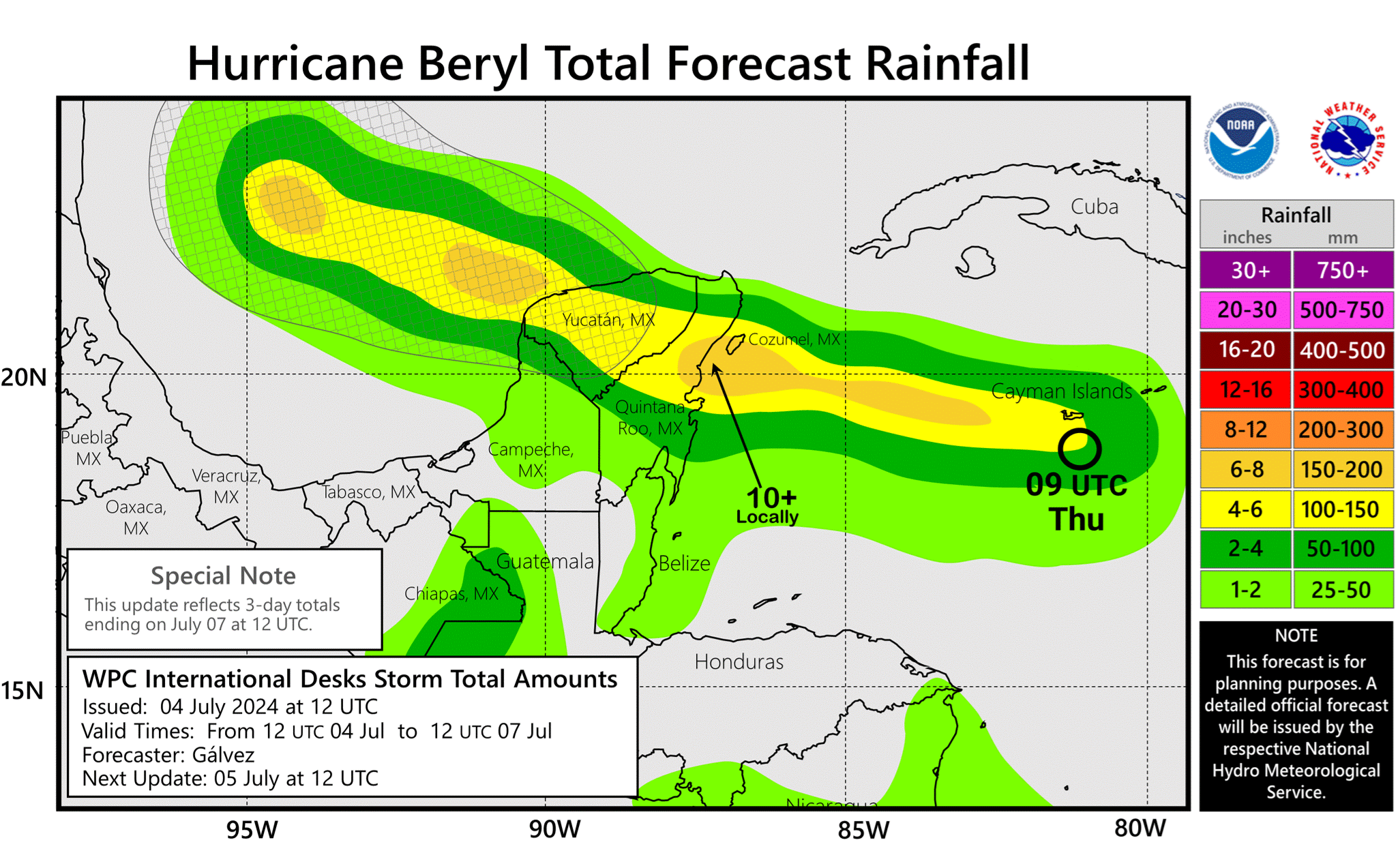
Beryl’s near-term track appears to have shifted a smidge to the north versus yesterday or is at least riding the northern half of the guidance envelope. This was probably enough to allow Beryl to ultimately come in on the Yucatan a little farther north than it seemed yesterday. Instead or near or south of Tulum, we’re probably looking at landfall near or north of Tulum. Significant storm surge, heavy rain, and hurricane winds are expected across the Yucatan and perhaps as far south as northern Belize (though the latter will be on the relative weaker side of the storm). Rain totals are expected to be upwards of 10 inches locally.
With Beryl being quick moving that should hopefully lessen the rainfall impact from the storm a bit.
What about Texas?
Most of our readership lies in Texas, so let’s talk about Beryl’s end game for a minute. Since yesterday, Beryl maintain some intensity and is tracking on the northern half of the guidance envelope. Obviously that brings portions of south Texas more into play for Beryl’s landfall. The Houston area remains unlikely to see any direct impacts from Beryl. However folks from Corpus Christi southward are very much in play.
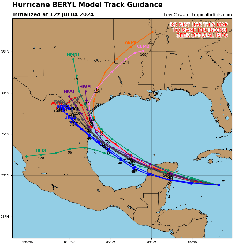
Modeling has been bouncing around a bit, but there’s been a significant shift toward a consensus in the last 18 hours or so. This places south Texas firmly in the possible crosshairs of a landfall from Beryl.
Exactly where it makes landfall is too soon to say, but interests from about Port O’Connor south to the Rio Grande will want to monitor the forecast the next couple days. Landfall would probably come around late Sunday night, with impacts beginning early Sunday. There is still a bit of uncertainty in what Beryl will look like when it emerges from the Yucatan, but it will have marginally favorable conditions to reintensify as it tracks toward northeast Mexico or south Texas. The expectation is that a hurricane will come ashore in that region Sunday night. We still need to work on intensity for it, but the current official NHC forecast is for a 75 mph hurricane near landfall. We remind people to not focus on the specific landfall point or intensity, as impacts will spread outward from the center. Even a landfall in Mexico would cause some impacts as far north as Corpus Christi.
Beryl looks increasingly likely to tap hard on the brakes as it turns northwest and comes inland. This means that Beryl is likely to produce several rounds of heavy rain across South Texas. Uncertainty on where Beryl meanders inland after landfall is very high. Beryl could stall out in South Texas or in the Rio Grande Valley. Or Beryl could just slowly drift north toward Hill Country. The current rainfall forecast for the region shows manageable rain, but some operational model guidance is beginning to get a little more unruly with rain totals above 10 inches in spots.
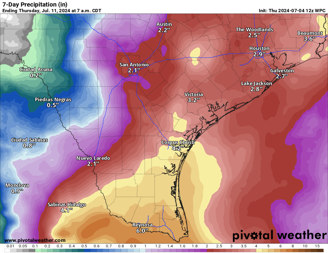
This is becoming an increasing concern with Beryl. A lot of areas in South Texas, the Rio Grande Valley, or Hill Country need rain pretty badly. However, while a slowing or stalling tropical storm can provide that, it can also provide problems. Folks in South Texas will want to continue to monitor changes to the rainfall forecast closely in the days ahead. The current expectation is that areas from Houston into Louisiana will see an uptick in daily thunderstorms next week but generally manageable rainfall. We will continue to watch this closely.
Beyond Beryl
Beryl was a good role model for Invest 96L. Much like its bigger sibling, 96L also refuses to give up, though it remains extremely disorganized in the Caribbean. It will follow Beryl west and northwest and may inject a dose of additional moisture into the rains over Texas or Mexico next week, but it seems unlikely to develop much on its own. Beyond that, it’s quiet and hopefully stays that way for a week or two.
Come on in to the Hill Country, Beryl! Canyon Lake is down 25 feet so it can handle your rain.
Be careful what you wish for lest you get it…
Yeah. I don’t think the hill country has seen a really bad tropical storm flood recently, but i have read that back in the 1900s tropical storms brought some of the worst floods to the area. We are more used to it in Houston, but it can happen out there too.
Looks like TX is getting lucky again this time.
I need a nap. Lots more of the season to go.
As a Houstonian there are two scenarios that concern me: 1) Beryl turning farther north and slamming into the coast between Freeport and Galveston and then tracking over the largest city in Texas, and 2) the storm stalling near Houston for several days and causing Harvey-like flooding. Since Port O’Connor is at the northern limit of the models shown on the map, can we rule out both of these scenarios for Houston?
Can you 100% rule them out? No. Can you 98% rule them out? Yes. I would be much more concerned about #2 than #1, but to this point, modeling has shown nothing remotely close to the numbers they showed in the days leading up to Harvey. Yes, heavy rain and flooding are possibilities I am watching closely for the Houston area, but at this point I would classify them as “manageable.” But should continue to be watched.
Thanks, Matt. Really appreciate the clarity.
The cone’s been moving north pretty consistently over the last few days, and Houston’s now within it, if barely. If the prediction keeps “correcting” itself the same way for a few more days, it certainly seems like a lot more than 98% chance to rule them out.
Sshh… Don’t say it out loud! I’m in Nacogdoches and no no no no!
Any thoughts on Monterrey NL MX I was planning on flying out of IAH Next Friday?
Should be fine by then I’d assume.
Also enjoy your dispassionate briefing
Thanks for all you do. And a special thanks for your patience with all of us.
I look for updates on anything that even mentions hurricane often.
I am living with a diseased super sized oak tree that I’m having taken down in increments as I can afford to but I won’t be able to afford to get it safe before the end of hurricane season so my anxiety level is high this year and I plan on leaving at the first sign of a hurricane coming to Houston. I would rather come home to a tree through my house than be in said house when it does. So, I thank you for your updates now more than ever. I have a feeling I may be packing my car often over the next several months.
The NAVGEM has been showing a Houston area direct hit for 2 days. I hope it continues to be the outlier!
What are the chances it hits Katy? Sorry, I’m new and have never seen a hurricane
What are the coastal areas of the Houston Galveston region going to be facing in terms of high tides? With the winds pushing the Gulf at us will low lying areas face the same kind of tidal flooding we saw with Alberto?