Headlines
- Beryl’s track nudges just a little to the east.
- Improving outcomes for Corpus Christi, but more gusty wind and rain for Houston.
- Beryl starting to try to turn the corner intensity-wise this morning.
- Isolated tornadoes and flash flooding a good possibility later today through Monday, improving Tuesday.
Tropical Storm Beryl (60 mph, NW 12 mph)
Beryl continues to struggle a bit this morning as it cycles through some of the dry air in managed to absorb yesterday. The core is now somewhat insulated from dry air, though it’s lopsided to the south and may still contain some residual dry air in there too. Over the next 6 hours, it will be key to see if Beryl can wrap some of these storms to the north side of the core. In that case, Beryl’s a-go for launch into landfall. If not, it will only modestly intensify further.
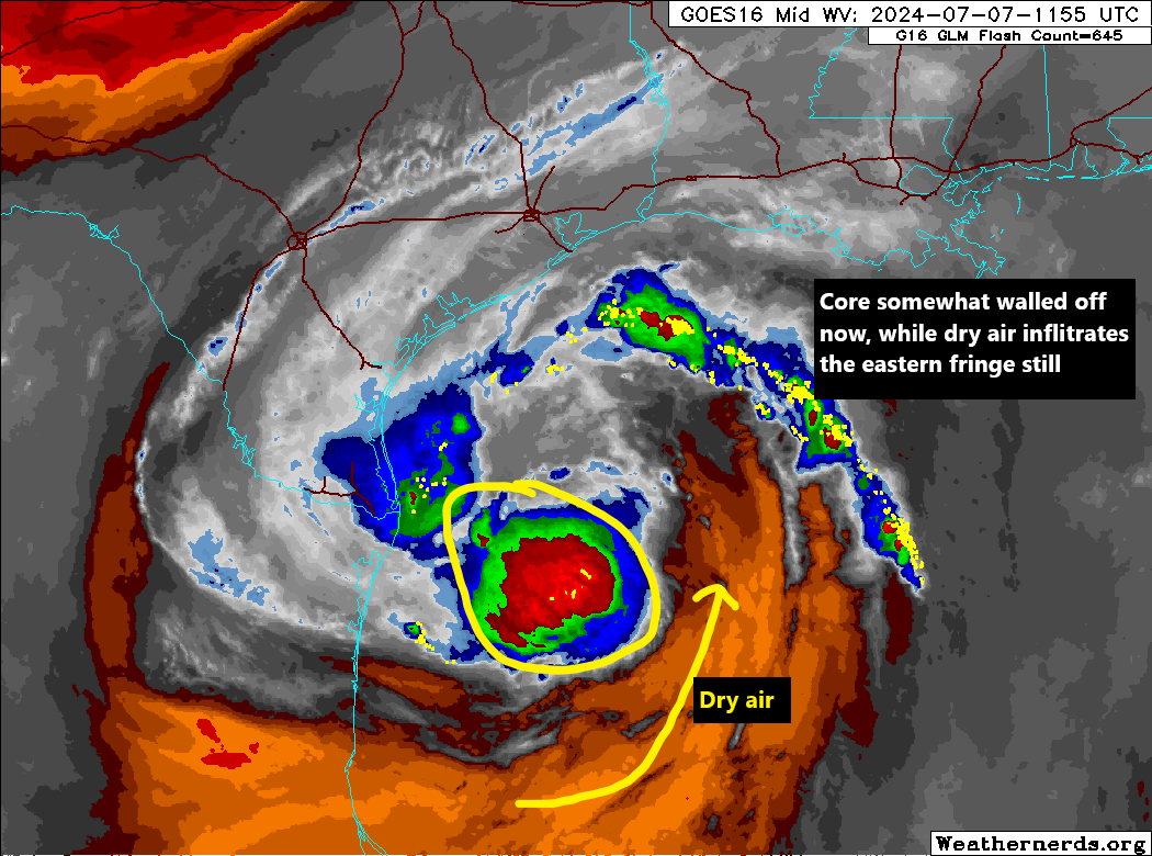
Beryl is still expected to come ashore as a category 1 hurricane tonight, but there is certainly risk that if this process accelerates it could achieve category 2 intensity. We expect, at best, a strong tropical storm, at worst a Cat 2 hurricane. It should be noted that hurricane-force winds will be primarily confined to a small area near and east of the center and likely drop off to tropical storm intensity as Beryl moves inland from the coast. Beryl will steadily weaken as it moves inland tomorrow and should be below tropical storm intensity by evening as it moves through east Texas. Tropical storm force winds are likely over a decent swath of Southeast Texas tomorrow, including the Houston area, strongest to the south and west of the city. Scattered to numerous power outages should be anticipated.
In terms of track, Beryl is mostly dialed in now, and it is likely to make landfall between Rockport/San Jose Island and Sargent, TX. Impacts will be skewed worst near landfall and to the east of where Beryl comes ashore. Hurricane Warnings are in effect from Baffin Bay through San Luis Pass. We can narrow this a bit further later today, but at this point, most of the impacts and track are in ink and changes to track should be primarily cosmetic.
For more details on specific impacts to the Houston metro area, please check Space City Weather.
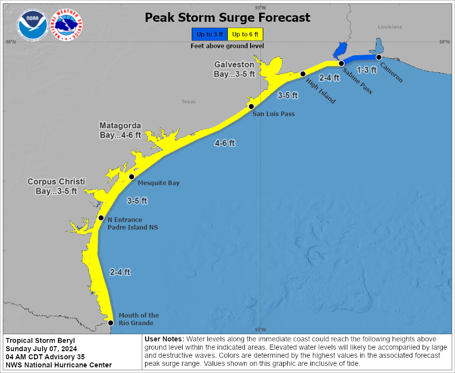
Surge forecasts for this storm are mostly unchanged today. We continue with a general 3 to 6 foot above dry ground forecast, similar to Alberto’s impacts in most places, except near and a bit to the east of where the center comes ashore, which will be higher than Alberto.
The good news with a faster storm is a generally lower ceiling on rain totals. However, this will have plentiful moisture, both with some precursor storms today and with the storm itself tomorrow. Rain totals are expected to generally be 5 to 10 inches.
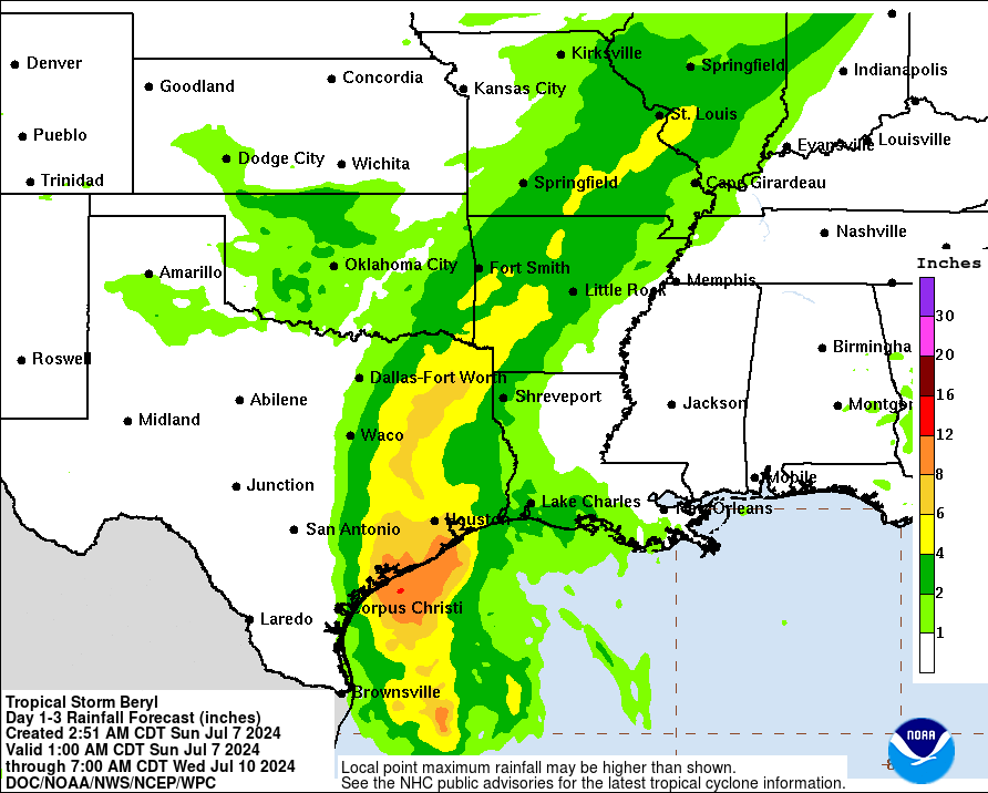
Flood watches are in effect for much of this track in Texas. There is a moderate risk (level 3 of 4) of excessive rainfall and flooding posted for much of where that core of rain goes. Subtle track shifts may reorient exactly who sees the heaviest rain, an important aspect of the storm for the Houston metro. No serious rain impacts are expected on the I-35 corridor or in Louisiana.
Isolated severe weather and tornadoes are a good possibility both with the storms this afternoon in the Houston region and again with the storm itself tomorrow.
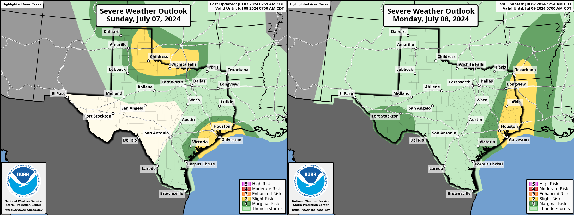
The SPC has southeast Texas in a slight risk (level 2 of 5) for severe weather today, expanding north tomorrow. Conditions should return to normal on Tuesday.
That’s it for now. We’ll update once more again this evening unless something drastic changes this afternoon.
How long will it take the storm to pass through a given area once it hits?
Worst will occur over a 3-6 hour window or less. Tropical storm conditions would last probably 6-10 hours total. Rain a bit longer than that.
At 15 mph speed of avg storm and with center 80 miles west, the far edge of circle of medium winds hopefully passes in 1 hour. Sometimes the cut off is quite sharp, thank the Lord.
Great.
My stomach has turned to acid.
Hello,
How big is the storm in miles from center with hurricane force winds, Ts, TD etc?
Do you know of a website that forecast wind speeds and direction for a location i.e., zip code by hour?
I do not see it on the app.
Thanks for your time and efforts.
Monty
Thank you for your time.
NOAA has it at 10 mph. Think it’ll start to speed up again any time soon?