Headlines
- Beryl on track for a middle Texas coast landfall on Monday.
- Hurricane Warnings posted from Baffin Bay north through Sargent.
- Flood Watches issued for much of coastal Texas and just inland.
- Beryl did not organize much more today, but it continues to look likely to intensify again tomorrow, particularly in the last few hours leading up to landfall.
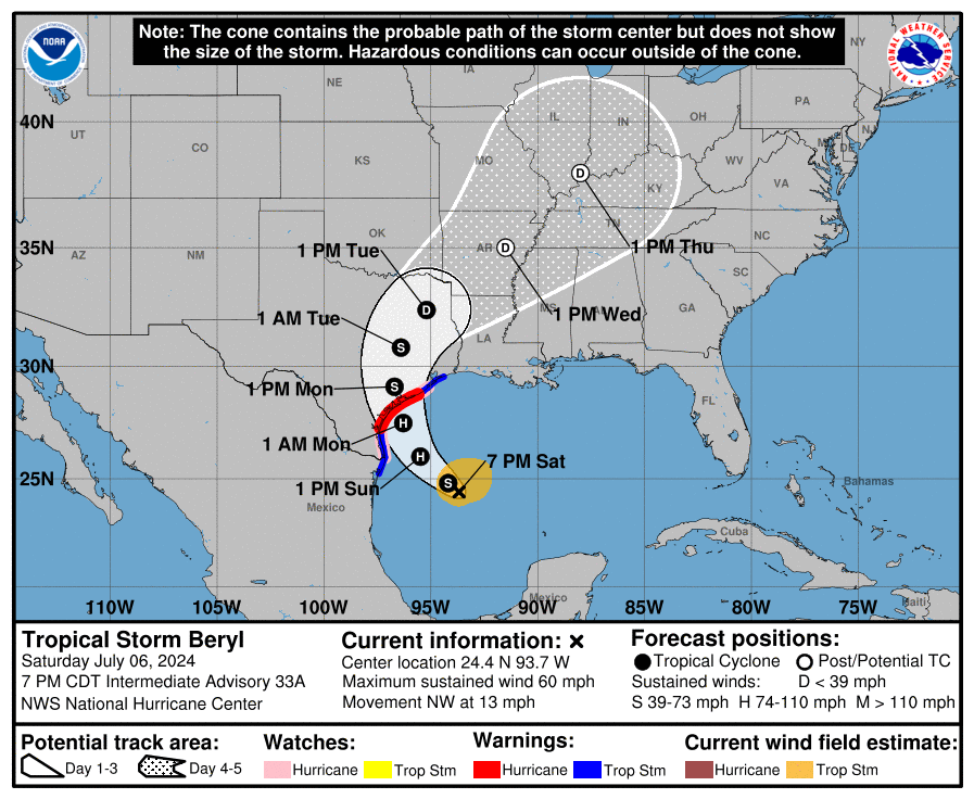
Tropical Storm Beryl (60 mph, NW 13 mph)
As expected, despite the burst of storms within Beryl’s circulation today, it failed to translate to any real serious organization or strengthening, and for all intents and purposes Beryl is mostly status quo since this morning.
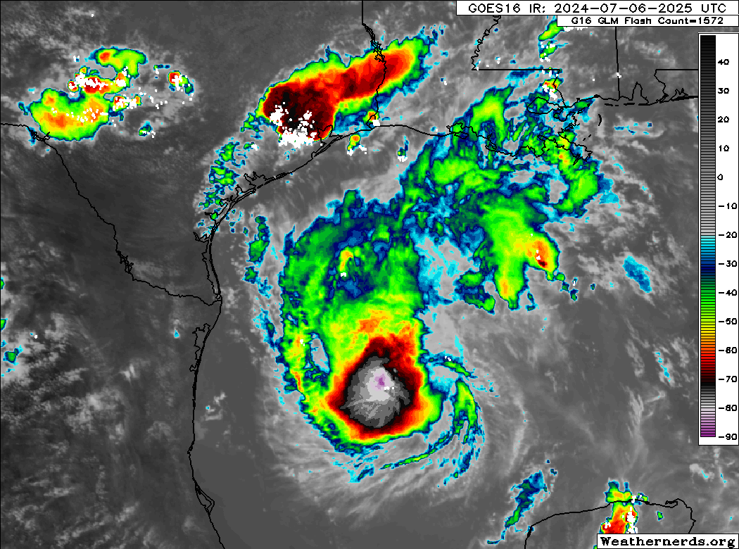
This was expected for the most part, and we continue to expect that Beryl will improve its environment tomorrow leading to a period of slow then possibly rapid intensification up to landfall in Texas. We are likely looking at a landfall in the morning hours Monday. The current NHC forecast is in line with most model guidance, showing a middle to higher-end category 1 storm at landfall. That being said, a couple usually reliable models do show Beryl with potential to become a category 2 storm with 100 mph winds at landfall. Do not be lulled to sleep by the lack of intensification today. This was what had been anticipated.
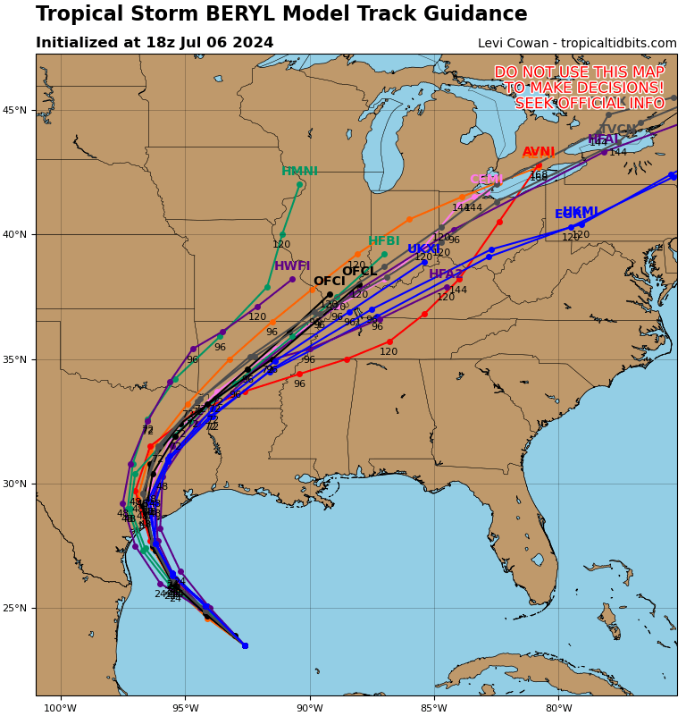
Where will that landfall occur? Again, impacts will spread out from the storm, but for the strongest wind and surge, that landfall point is important. We have seen little movement in the modeling today with the bounds between about Sargent, TX through Corpus Christi Bay looking most likely to see the ultimate landfall of Beryl. I think the risk is probably skewed more to the right half of that spread, somewhere near Matagorda Bay. The risk drops east of there toward Galveston (albeit not quite zero) and west of Corpus Christi. Hurricane Warnings are posted from Baffin Bay through Sargent. I would again say that the risk is highest in the eastern half of that warning spread, but folks in Corpus Christi should continue to finalize any preparations they’ll be implementing.
Let’s talk a little more about some of the impacts from Beryl beyond wind.
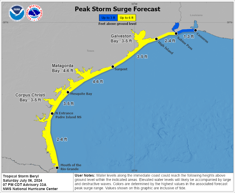
Storm surge will be a serious concern in the Matagorda Bay region, and water levels of 4 to 6 feet above normally dry ground are expected. This will be at least a couple feet higher than experienced than last month in Alberto. From San Luis Pass through High Island, the storm surge will be similar to what was experienced during Alberto, and for Cameron Parish, LA it will be similar or lower than what was seen during Alberto. Heed the advice of local officials in terms of evacuation orders or other preparations at the coast. This storm is likely to come in stronger than Hurricane Nicholas in 2021, the most recent direct hit in this area.
Power outages are likely to be widespread in the Matagorda Bay region of Texas. Isolated to scattered power outages may impact the Coastal Bend or the coast up through Brazoria County, including Freeport, Lake Jackson, or Galveston. Additional isolated to scattered power outages may impact the greater Houston area’s south or west side, including heavily populated Fort Bend County depending on the exact track and speed of Beryl.
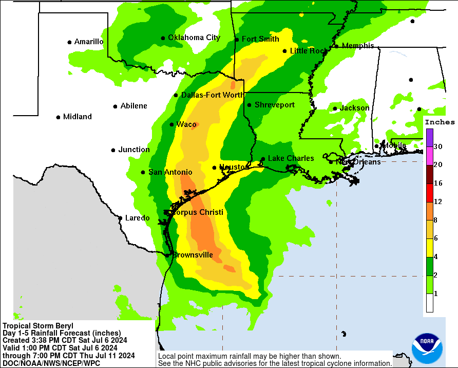
Rainfall is another issue with Beryl. The good news is that Beryl will not stall or do weird loops over Houston and southeast Texas. The bad news is that Beryl will be moisture-laden and able to produce a period or a couple periods of torrential rainfall Monday. The current forecasts with Beryl’s track shows a narrow corridor of very hefty rain totals along and just east of the center. The exact track will determine who gets 4 to 6 inches of rain or who gets 8 inches of rain or more. For urban areas like Houston, this will be a critical threshold in terms of minor to moderate flash flooding versus something more serious. Current rain forecasts pinpoint Wharton through College Station up north to near Tyler and east of Dallas for the heaviest rainfall. Look for more on this tomorrow.
As is the case with most landfalling tropical systems, isolated tornadoes will be a possibility on Sunday night or Monday as Beryl comes ashore. This would be primarily east of where the center comes ashore, including the Houston and Galveston areas, possibly as far east as Beaumont or Port Arthur. Expect several tornado warnings on Monday with a handful of possible tornadoes.
We will have the latest for you in the morning after we see what Beryl does tonight.
What’s the most it could rapidly intensify to? A 5 at landfall?
In the post, it was said that a cat 2 is possible.
Will the Lake Jackson area see 100mph winds?
Thanks for the update. I’ve looked and wind possibilities but it’s not clear to me. How far from the eye do the strongest winds go? Meaning I live ~80 miles inland, somewhat east of the track (far NW Harris County) Do max winds go that far inland? Always confuses me when I see max sustained and how that correlates further away from the storm.
Appreciate all y’all do!
We are wondering the same.
Thanks for staying on top of this guys! Y’all are doing a bang up job trying to herd this cat.
Thank you! I hate, hate, hate tornadoes. Hopefully they will just be funnel clouds that don’t touch down as tornadoes. Thanks for all y’all do.🙏
Sammme girl. That scares me worse than the hurricane. That’s the main reason I’m outta here ✌🏽But then again Twister is one of my faves so that may be my fault.
“for all intents and purposes”, I am enamored of someone using this phrase correctly.
Hats off to whomever taught you excellent grammer!
Does the Galleria get 12” or more in a day from Beryl?
We appreciate your great work!
I work in San Leon right on the water tomorrow morning, Sunday. When is the surge expected to come in? I don’t want to be stranded down where I work lol.
Hopefully the storms won’t become to intense.
You guys are amazing! Can’t thank you enough for your wonderful coverage. Our daughter and family live in Seabrook, and we try to stay aware of all that happens there. Here in eastern PA we just get occasional leftovers. Many people are appreciating you these next few days.