Headlines
- Tropical development odds are close to 50/50 in the Caribbean over the next week.
- Initially, if anything develops, it is unlikely to move a whole lot, rather just sitting over the Caribbean.
- Eventually, we may see a slow west or west-northwest movement.
- Interests from Central America through the Caribbean should monitor updates on this.
Apologies for the lack of post yesterday, but I was preoccupied with some other things most of the day. Let’s get into things this morning.

Eyes on the western or central Caribbean
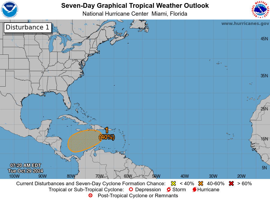
Development odds are officially up to about 40 percent now in the Caribbean over the next week, as it appears we will enter a somewhat more active period in the tropics for November. The first thing I think we can say with some confidence this week is that this is not going to be a quick process. If this develops into an organized tropical system, it will take its time. The most likely outcome is that whatever forms here is likely to kind of fester for several days before trying to develop. We can sort of see the beginnings of stuff over the Caribbean this morning.

We’ve got nascent thunderstorms all around the periphery of the Caribbean right now. But over time, we will probably see more thunderstorms focus themselves in the central or western Caribbean. This is what could fester its way into development this weekend or early next week.
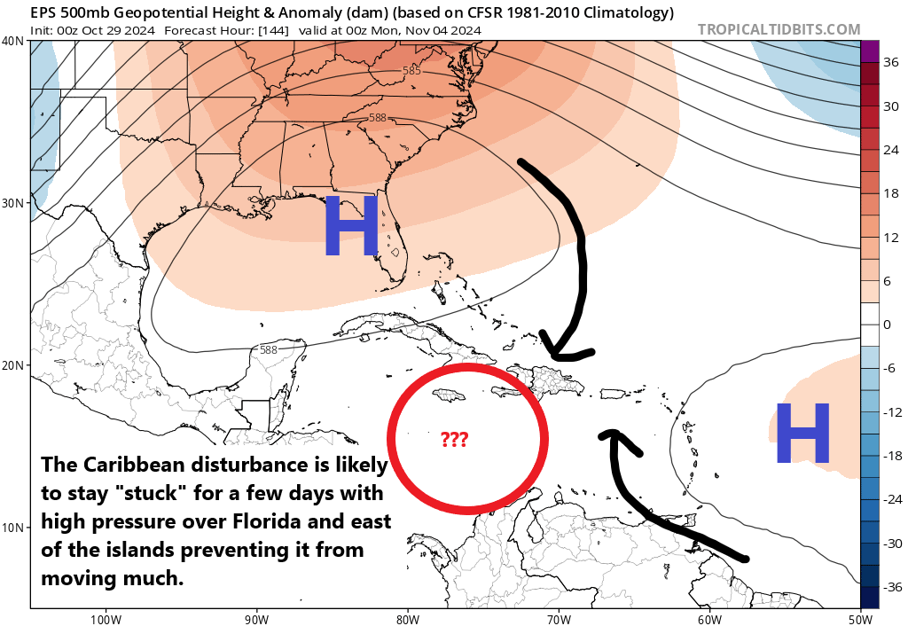
What will probably end up happening is over the next week or so, we see this begin to pop up and fester in the Caribbean. Heading into the late weekend, high pressure over Florida and the Gulf and a second high pressure system just east of the islands will impart opposite movement on the disturbance, which basically cancels out. The steering currents shift to near zero. In other words, what starts to develop in the Caribbean will be unlikely to move a whole lot initially.

Over time, high pressure in the Gulf will probably stay in place, while high pressure east of the islands weakens. This may allow for a very slow northwest or west movement within the Caribbean next week. Exactly what this means is somewhat unclear at this point but we have several days to watch this. I don’t believe we will see any marked organization of anything until at least Sunday or Monday. For now at least, I would not be too worried about this in the United States, but interests from Central America across the Caribbean should be checking back in with their sources every day or two for updates on this. We will obviously keep watching.
More to come tomorrow.
Beyond this area, there is not a whole lot to focus on at this point.
Dude,
No need to apologize. We love your stuff. Be good to yourself.
So, Uncle Fester in the Caribbean…
👻
Spooky Szn is actually from May-November!
Lol 🎃
I’m confused.
In this post, it is stated, “Eventually, we may see a slow west or west-northwest movement.”
.
I’m at the NHC website at this moment and it states, “… while the system begins to drift northward or northeastward toward…”.
.
Nothing to worry about at this point about the possible disturbance. But it’s interesting the difference of opinion related to potential movement.
I think the general consensus is that it will drift more to the north or northeast, as that’s climatologically what usually happens this time of year. Given the pattern setup though, I don’t want to rule out some sort of west or WNW nudge for a little bit. I think the bottom line in all this is that we have potential for a system but we don’t have a great idea of where it may go and what it may do exactly. History argues it goes east; model data may argue otherwise, at least temporarily. But I think the entire Caribbean at least should be keeping tabs on it.
Going to Cozumel Thursday-Tuesday. Should I be concerned?
Thank you!!! Great report (as usual).
Great report (as usual).
Traveling to Eastern Caribbean..specifically St Thomas, St Kitts & Cocoa Cay on Royal Caribbean. Should I be concerned and cancel excursions I’ve got booked on the islands? I’m new to cruising
Don’t cancel anything, but keep an eye on the forecast as it comes into focus.