Headlines
- No tropical development is expected this week in the Atlantic.
- A tropical wave has a growing chance to develop next week just east of the Caribbean islands and is worth watching.
- The overall background in the Atlantic may become more conducive to tropical development by mid-September.
- Hawaii will see modest impacts from the remnants of Hurricane Gilma this weekend.
Another quiet week
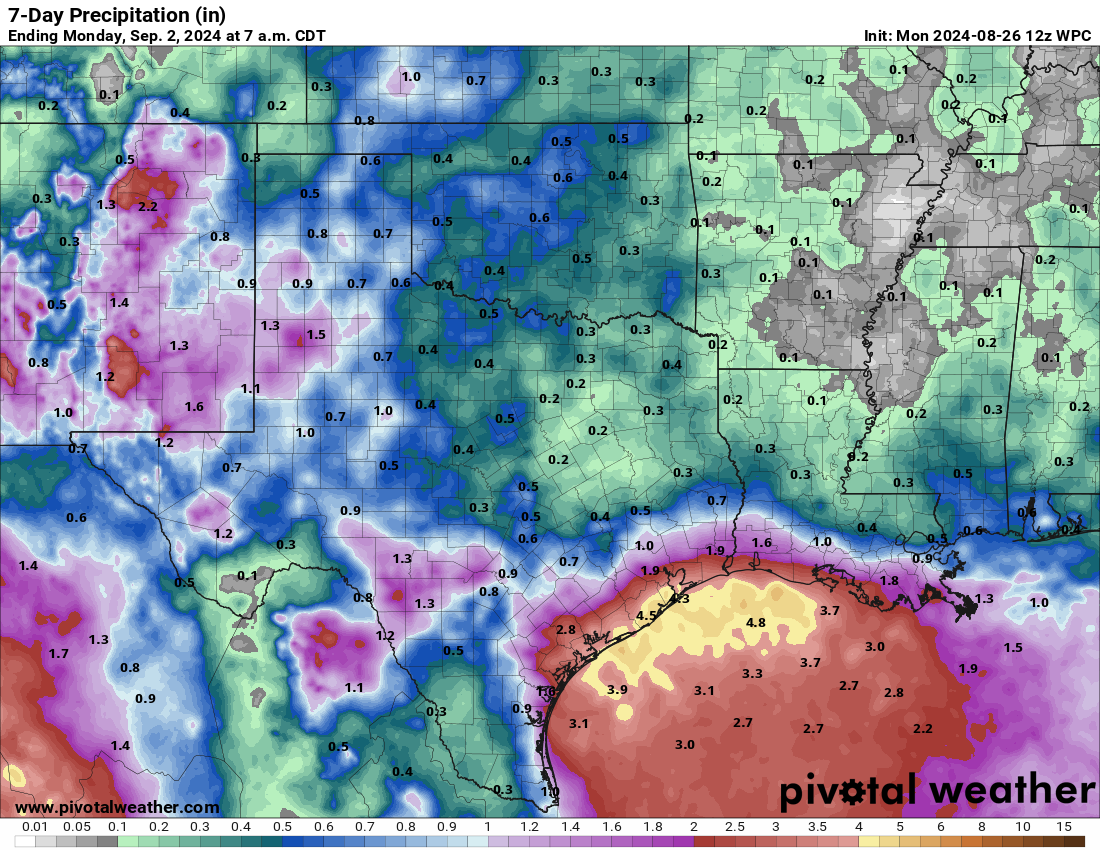
The Atlantic will remain quiet for another week here, as we have no real development chances anywhere in the basin of note. The Gulf Coast will be busy with showers and thunderstorms, but no development is expected from anything.
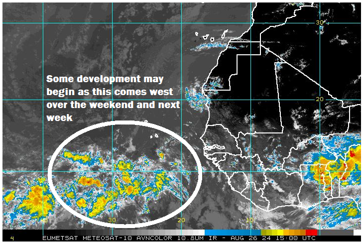
The eastern Atlantic looks quiet for now as well, however there is a tropical wave sitting out there. While it is unlikely to organize this week, it is becoming increasingly plausible that we see this begin to organize a bit as it approaches the islands next week.
Will we get Francine?
The next name on the list is Francine, and there seems to be growing support that we may see this emerge from the morass in the eastern Atlantic in time. The European model is on this with a moderate signal for possible development near the islands next Tuesday.
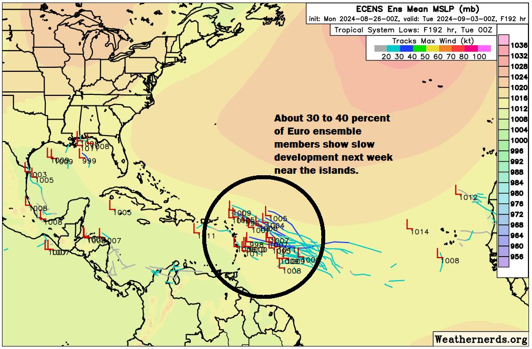
I think things are still a bit tenuous in the Atlantic in terms of dry air, sinking air, and other issues that are disrupting development right now. But the overall background state of the western Atlantic is likely to improve a bit beginning next week for possible development chances. There is also a minor signal in the Gulf for next week, but it remains a minority of model solutions. Still, this would signal that the wet pattern in the Gulf should continue next week as well.
As for the potential of Francine, whatever happens with this system in the Atlantic, it seems most likely to turn northwest at some point. But until we get some additional clarity on how this will shake out, I don’t want to over-speculate. At the least, it would be good for the islands to keep tabs on this possible development next week.
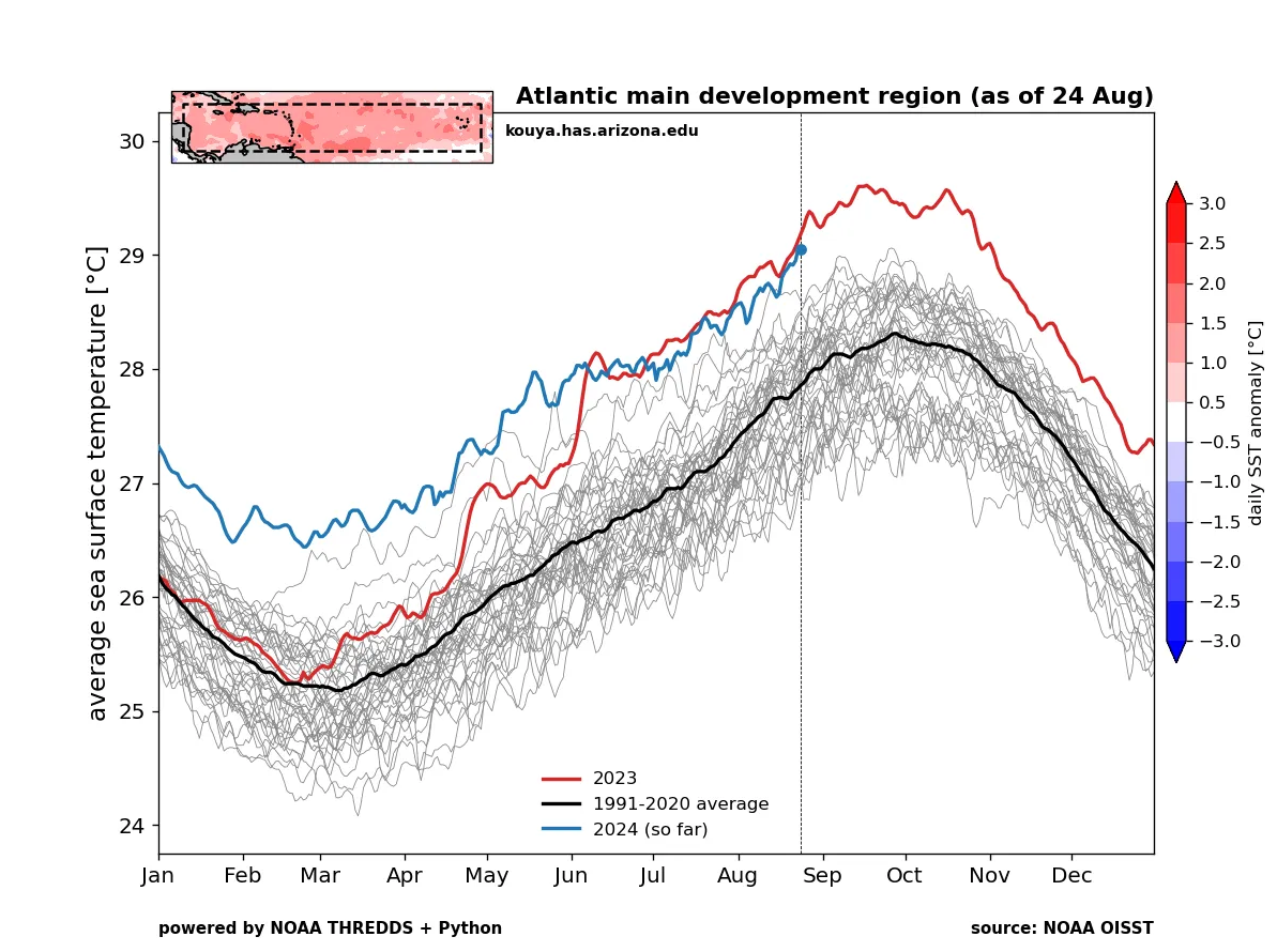
Beyond this one, as I noted above, it does seem as if the overall state of the basin will improve going into the middle of September. This should allow things to pick up. In addition, all this quiet has allowed the Atlantic basin’s sea surface temperatures to persist very warm. We sit at or above records everywhere right now.
So it would make sense to think that as long as the background state of the basin becomes more hospitable for tropical development, it will begin again in earnest. Stay tuned.
Hawaii threats continue
After taking swipe from Hurricane Hone with some considerable flooding on the Big Island and some decent wind gusts. You can see some of the reports here. Next up, the remnants of Hurricane Gilma, which should arrive in the Hawaiian Islands this weekend. On this track, the worst of the rain impacts would likely pass north of the islands. Still, some modest impacts would be possible across the islands this weekend as it approaches and passes.
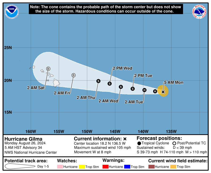
Behind Gilma, we have Tropical Storm Hector, which is not expected to become a serious threat to Hawaii.
Why are none of the western Atlantic and Gulf thunderstorms developing into tropical systems? The Caribbean and Gulf are both about all time record warm. What is keeping things from developing there? (e.g. what happened to that tropical wave you mentioned a few days ago around the Bahamas or something?)
I’m wondering this too
A number of issues…we have sinking air over the basin right now, and it tends to suppress storm development. That’s going to slowly migrate eastward, so hence our thought that things will pick up. We’ve also had sprawling high pressure over the Gulf all month in some capacity. That’s just now breaking down, and as noted there may be a Gulf disturbance to at least watch next week. This first one just rolled into Texas with no fanfare. So warm water alone will not produce storms! But it’s been a lesson this year so far in atmosphere-ocean complexity…the two don’t always work the way you assume.
Hey Matt, I have a question about the use of language. In this piece you write: “…the overall state of the basin will improve going into the middle of September. This should allow things to pick up.”
When I read “will improve” my first thought is that things will be less likely for storms, thus “improving” things for all of us. When I see what you actually mean, in no part of my mind or preferences do I think of that as a situation that can be called in any sense “improvement.” I understand the relative nature of this term and the situations in which it is used, but would you please consider a different sentence structure?
I’m thinking a phrasing like this as a suggestion: “…the overall state of the basin might just mean storms will be more likely going into the middle of September. Be prepared accordingly.”
Just my thoughts. Thanks for all y’all do!
“Improving in connection with hurricane formation” would you think? This is after all a storm forecasting site.
I was a little sloppy today with that one, but you are 100% correct. Favorable and improving are two words that can mean very different things to the audience of a meteorologist!
You have to pay a bit of attention to how forecasters talk. They are great explainers but will use the technical terminology in discussing storm formation and intensity. If they used the opposite and switched improved to be the potential positive impact on you they would be poor science communicators. These science communicators want to translate the weather while brining you and me on board standard communication.
I read there is a CAG setting up for Sep & Oct. Is that something to be concerned about? Thx.
Difficult to say that this will occur, as those don’t show themselves until late in the game. But historically, late September and October can allow for a CAG setup (Central American gyre for those reading and confused). Nothing to be concerned with right now at all. May change in a few weeks though.
Why will Hector follow Hurricane Hone? I don’t see Hone on the pacific list of names for 2024.
I think Hone is from the Central Pacific list
Hi @Ann K.
Quote from NHC website:
.
NHC issuing advisories for the **Eastern** Pacific on Hurricane Gilma and TS Hector
.
CPHC issuing advisories for the **Central** Pacific on TS Hone
Wow the 12z Euro models are really pushing the east Atlantic storm. This could be an East Coast threat.
Looks Ernesto-y to me right now, but yes, this is the time of year to be watching!
Uh – oh.
I just checked the NHS “7-Day Graphical Tropical Weather Outlook”. There’s a possibility cone (my wording) they’ve drawn for the Central Tropical Atlantic.
…
* Formation chance through 48 hours…low…near 0 percent.
* Formation chance through 7 days…low…20 percent.
I jumped to the Fox 24 Hour Weather TV channel, knowing they’ll be over-analyzing this. (yes, they’re discussing it).
Hey, we talked all about it today too! 🙂