In brief: We’re watching for Pacific development again later this week, while the Atlantic remains quiet. We dive into absolutely obscene humidity levels in the Northeast yesterday, the continuation of the heat wave, and the latest on flooding risk in New Mexico today. We also look at how all these things are related.
Atlantic update
Invest 90L is just about out of time in the open Atlantic. It has about 12 hours left before it basically gets absorbed into the overall pattern and ushered east with the window for development closing.
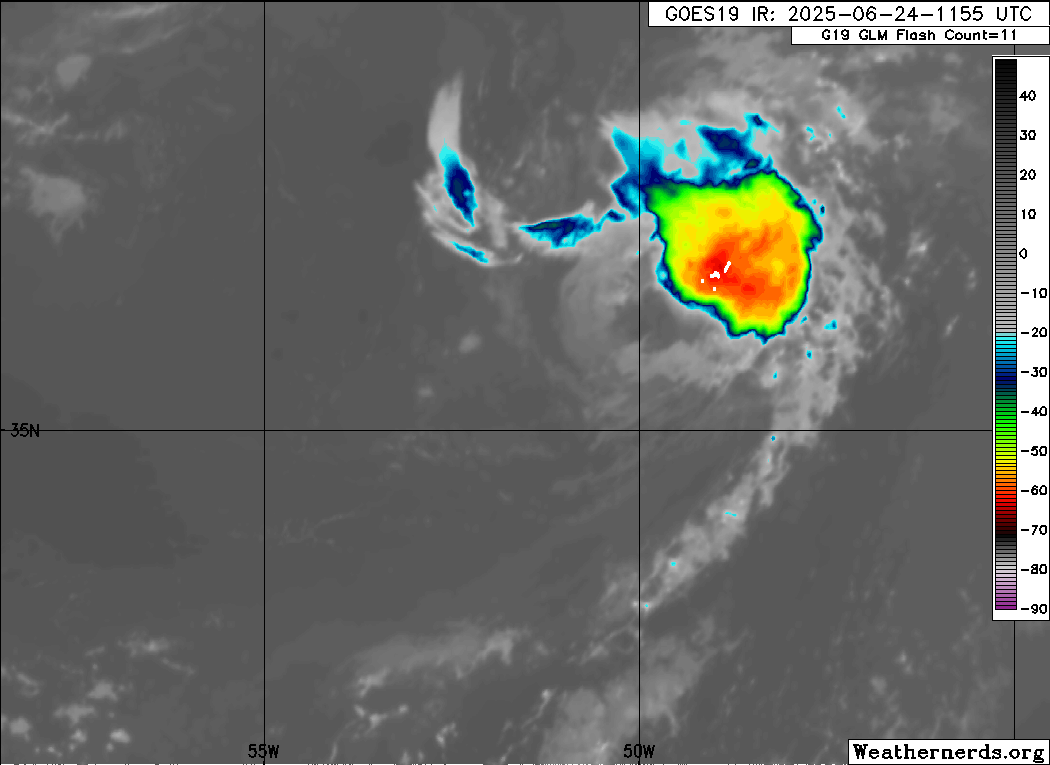
The satellite presentation of 90L this morning is actually fairly feisty looking. Whether it’s enough to get it over the hump and classify it as a depression is really a matter of technicalities at this point. We’ve certainly seen worse looking tropical systems in recent years, so I wouldn’t be shocked if this gets revisited in the postseason analysis. Regardless, this is heading out to sea and is no threat to land. The rest of the Atlantic looks quiet at this point.
Pacific update
On the other side of the continent, we are likely to see the next disturbance emerge off Mexico and into the East Pacific later this week. Right now, the NHC assigns about 70 percent odds of development for this system but probably not til the weekend.
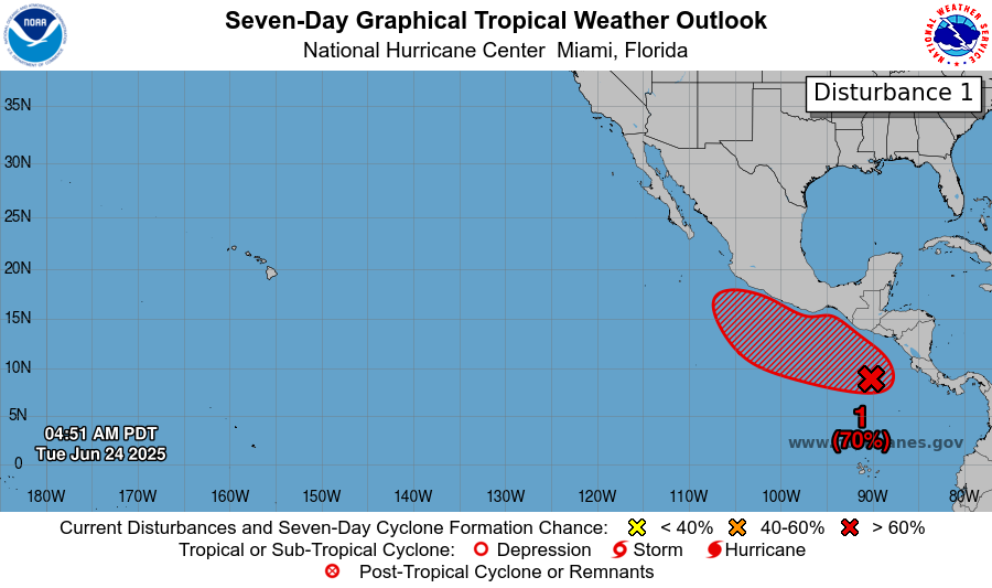
Most modeling suggests this will slide out into the open Pacific, but there remains some subset of model data keeping it fairly close to the coast of Mexico south of Baja. We’ll see if that comes into clearer focus in the coming days.
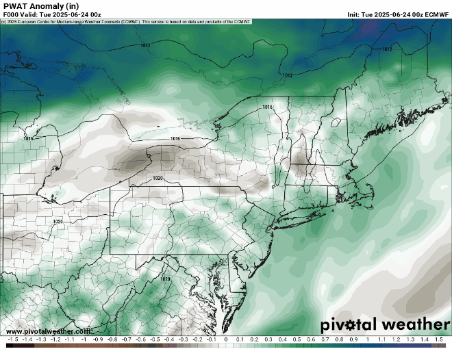
Absurd Upstate New York/Vermont humidity
Meanwhile, hoooo boy. I worked for 5 years in Central New York in the Mohawk Valley, not far from the foothills of the Adirondacks. We experienced some hot weather every summer just like any other place. But the level of absurdity of dewpoints yesterday in western New England and Upstate New York was wild. Dewpoint is a measure of the amount of moisture in the atmosphere, or the temperature you’d have to cool the atmosphere to for it to be saturated. Essentially, the higher the dewpoint, the worse it feels outside.
When you combine the temperature and dewpoint, that’s generally how you measure the “feels like” or “real feel” or “heat index” value. Yesterday, Whitehall, NY, which mind you is not exactly some urban heat island on the Gulf Coast measured a heat index of 117° from the New York State Mesonet. That is…absurd. Since the year 2000 (LaBamba from Conan O’Brien voice), Burlington, Vermont has recorded exactly 1 hour with a heat index of 110 degrees back in July 2002. To the south, Albany has had a couple hours up to 109° back in 2011 and 2018. The highest heat index value to date in 2025 here in Houston has been 107° on June 20th. Hourly records for things like heat index are often hard to track, but I think it’s pretty clear that what happened yesterday in Upstate New York and Vermont was an exceptional weather event.
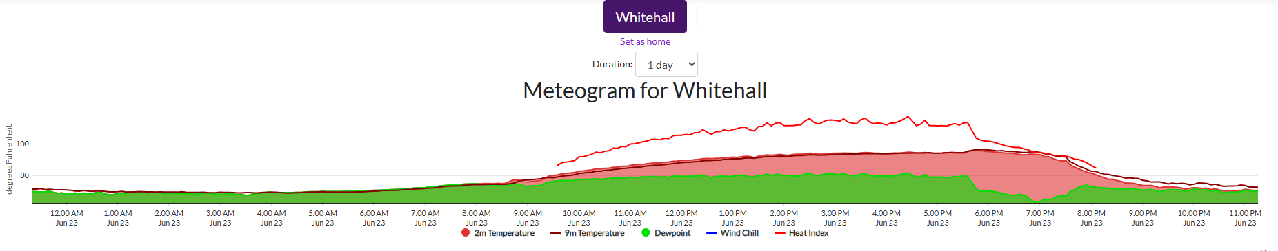
At one point, dewpoints got over 80 degrees at Whitehall, which I can’t recall really seeing up that way. Even Montreal had a dewpoint as high as 77° and a heat index of 105° yesterday! I went back through hourly data since 2000. Albany, Burlington, Syracuse, and Montpelier have never touched an 80 degree dewpoint in that time. Having lived there and grown up in South Jersey on the Jersey Shore, which can get rather muggy, it’s somewhat astonishing to me that it got this humid. Heat isn’t uncommon in New England or the Northeast. This sort of humidity, however, is either exceptionally rare or almost unheard of.
Heat outlook
The heat will roll on. Another round of numerous daily temperature records will be threatened today, from 100s in the Northeast Corridor to upper-90s in the interior, and plenty of humidity to boot once again.
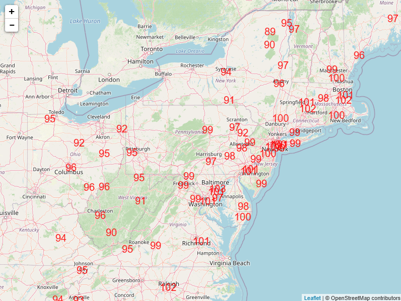
In fact, the amount of available moisture tomorrow, especially in northern New England and Upstate New York will be very high. Precipitable water, or how much moisture is available is expected to run about an inch above normal in those areas. A really, really impressive setup continues.
New Mexico
Heavy rain is expected today across much of New Mexico, leading to flood watches and a moderate risk (3/4) of excessive rainfall leading to flooding.
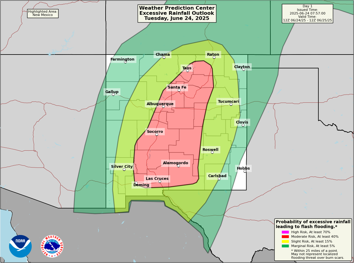
Rain totals of 1 to 4 inches are possible today, which will produce pockets of flash flooding in parts of the state affected by recent heavy rains. Some places have seen 2 to 4 inches in the last 72 hours. This becomes of serious concern near and below burn scars that dot portions of the state from recent wildfires.
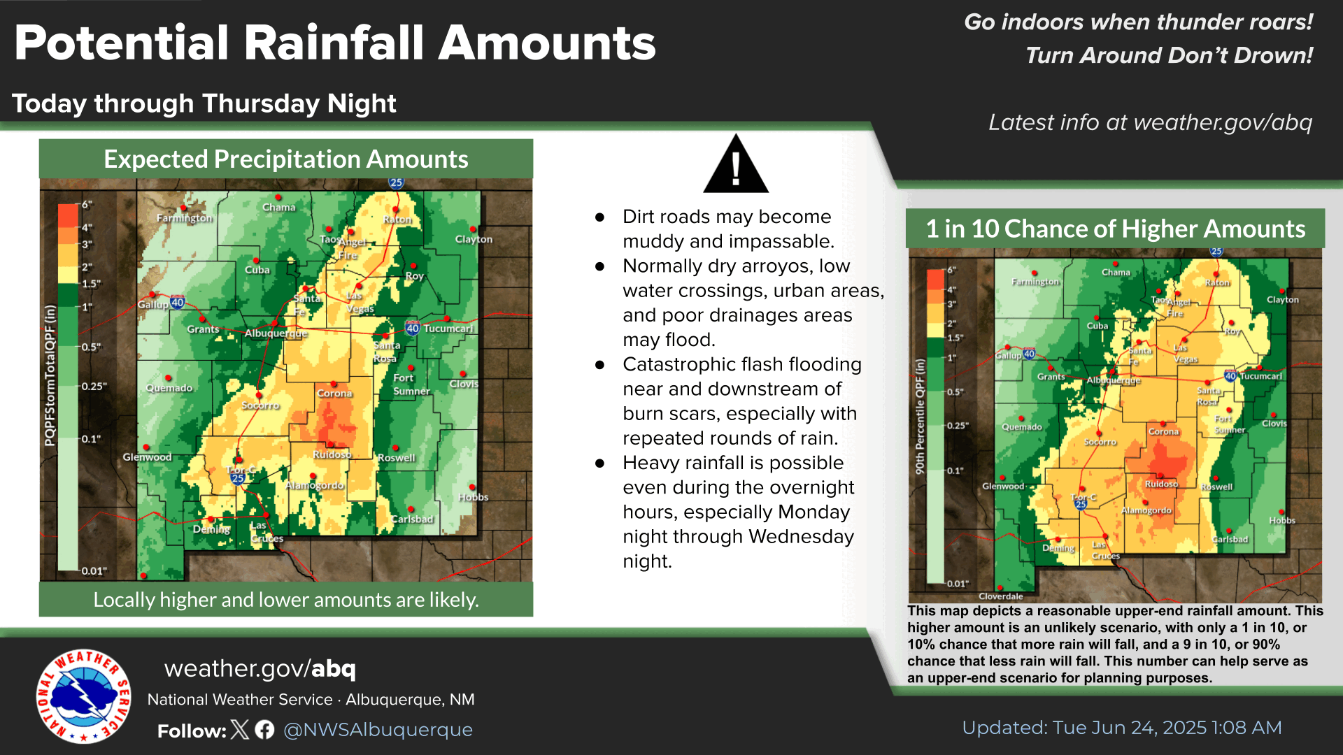
The forecast amounts are highest in the southeast, but it won’t take much for some of those higher amounts to show up elsewhere, including some risk of urban flash flooding in the Albuquerque metro. The flood watch in New Mexico remains until Wednesday morning in most spots, but through tomorrow evening in the South Central Mountains in the state.
Connecting the dots
Why is this happening? It all ties into how the weather pattern is interplaying at a large scale. With near-record high pressure over the Mid-South and Appalachia, as well as a deep trough over California, the flow pattern is drawing in Pacific moisture, including tropical moisture. That moisture funnels between the ridge and trough, taking aim at New Mexico, hence today’s flooding risk, as well as into the Upper Midwest, Lakes, southeast Canada, and U.S. Northeast. This provides higher than usual humidity, more thunderstorm chances, and some severe weather around the periphery of the ridge of high pressure.
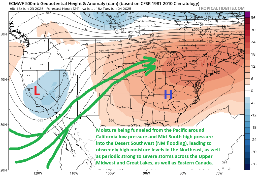
In addition, thunderstorm chances on the Gulf Coast have also increased this week due to east to west winds due to the clockwise flow around the high pressure system, with more Gulf and Atlantic moisture pressing across the Deep South and into Texas. Some of that Gulf, Gulf Stream, and even Caribbean air is getting dragged into this whole thing too. With this high pressure being near-record intensity, it underscores that extreme patterns tend to produce extreme outcomes.
Everything is connected in some way on this planet. We’re experiencing a microcosm of this now in the U.S. and Canada.
Thank you for expert analysis on weather conditions and climate impacts.
As a 20-year veteran of Houston heat who now lives near Albany NY, I can attest that it is hot. Because AC is not nearly as common here, the experience is like one of those multiday power outages after a tropical storm back in Texas.