In brief: Deadly flooding hit parts of New Mexico yesterday, while significant street flooding occurred in Chicago. Flooding risks should cover the Carolinas through New Jersey today, with a focus on Virginia perhaps. The tropics remain calm.
Note: Most of the data in these posts originates from NOAA and NWS. Many of the taxpayer-funded forecasting tools described below come from NOAA-led research from research institutes that will have their funding eliminated in the current proposed 2026 budget. Access to these tools to inform and protect lives and property would not be possible without NOAA’s work and continuous research efforts.
More flooding, more places
If you live in Ruidoso, New Mexico, you have been under a flash flooding warning over 25 times in the past year and nearly 10 times this year. Last June, the South Fork Fire devastated parts of that region, destroying nearly 1,500 structures. As is often the case after a wildfire, debris flows are serious issues. Basically, all that now loose ground becomes mud and debris and rushes down hills and mountains into rivers and imperils communities. In other words, it’s a looming disaster after a disaster. After the Thomas Fire in 2017-18 near Santa Barabra, CA, a debris flow in January in Montecito killed 23 people.
Ruidoso is situated in a location that tends to get summertime thunderstorms during the monsoon and just generally sits in a place where rising air and terrain effects can enhance precipitation. Ruidoso averages nearly 22 inches of precipitation annually, whereas Albuquerque averages less than 10 inches. Yesterday, rainfall of about 2 inches in an hour fell within Ruidoso, with radar estimating higher amounts just west of town.
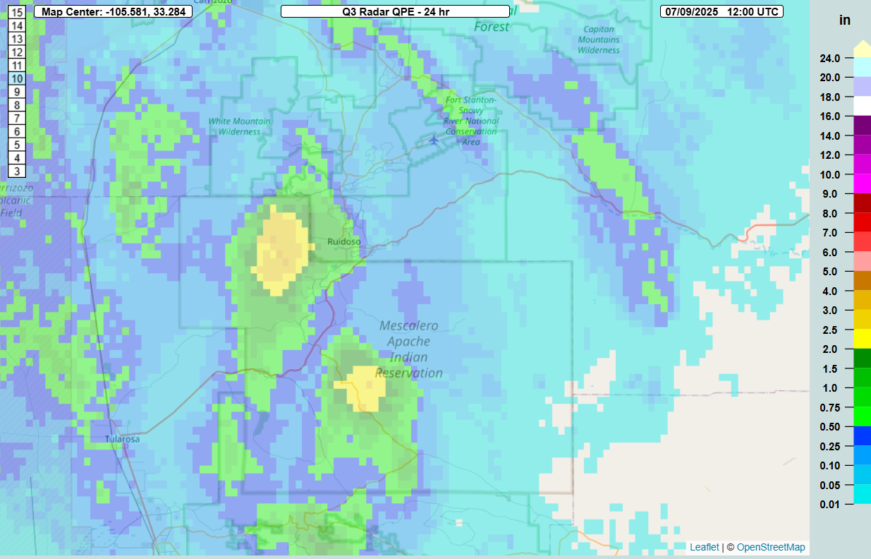
All that water pushed through the community. You can see just how quickly this happened. The water rapidly rose around 4 PM and by 8 PM, the river was basically back to normal. It happened essentially in a “flash.”
The river gauge at Hollywood, just downstream from the town of Ruidoso is what you’re looking at above. The river gauge observations are shown below.
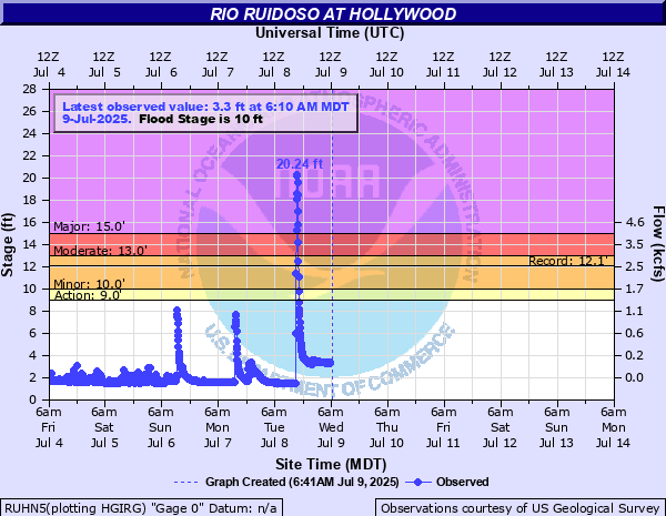
That’s a 20 foot rise in minutes. I’m not going to embed any other video here out of respect for many of our Texas readers still grappling with our own disaster. But you can search Google News, Twitter, or BlueSky for “Ruidoso” and find numerous pictures and videos. The flooding killed three, including two children and caused widespread damage. It also appears that this is the new flood of record for this area.
Chicago flooding
A slow-moving thunderstorm with torrential rain sat over the urban core of Chicago last night dumping 2 to 5 inches in short order. Rates of nearly 2 inches per hour were recorded right near the West Loop, and some other gauges had even higher rates. Most impressively, over 5 inches of rain fell in 90 minutes near Garfield Park.
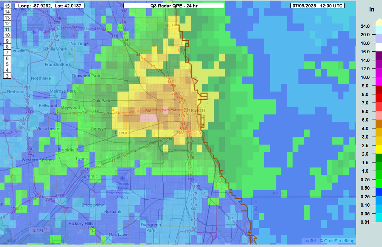
Damage was mainly due to cars in flooded roads it appears, though water did come close to getting into some homes. No deaths have been reported as of this morning.
Both southeast New Mexico and Chicagoland were in marginal risks (1/4) of excessive rain and flooding yesterday.
More flooding to come?
Yes, more flooding is likely. Today’s focus will be in Virginia. Much of the southeast half of Virginia has seen 1 to 3 inches of rain in the last 3 days, with the places just east of the Danville area hit by 4 to 7 inches of rain due to Chantal’s remnants the other night.
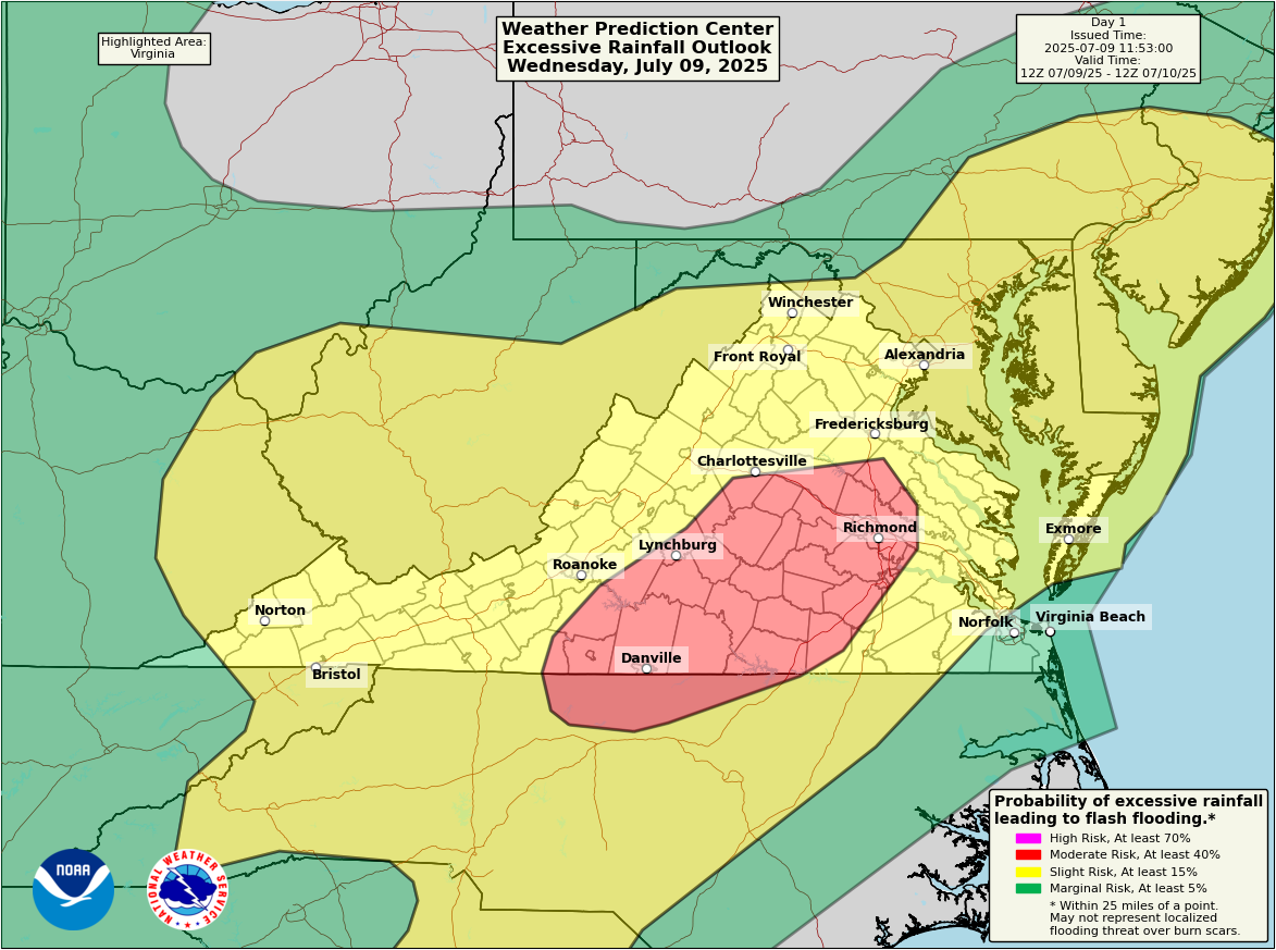
Much of Virginia, including Danville, Richmond, and Lynchburg are encased in a moderate risk (3/4) of excessive rainfall today. High-resolution weather modeling, such as that from the Storm Prediction Center’s HREF model do show the potential for 2 to 5 inches of rain today in pockets across Virginia, as well as perhaps into New Jersey, Delaware, Maryland, or North Carolina.
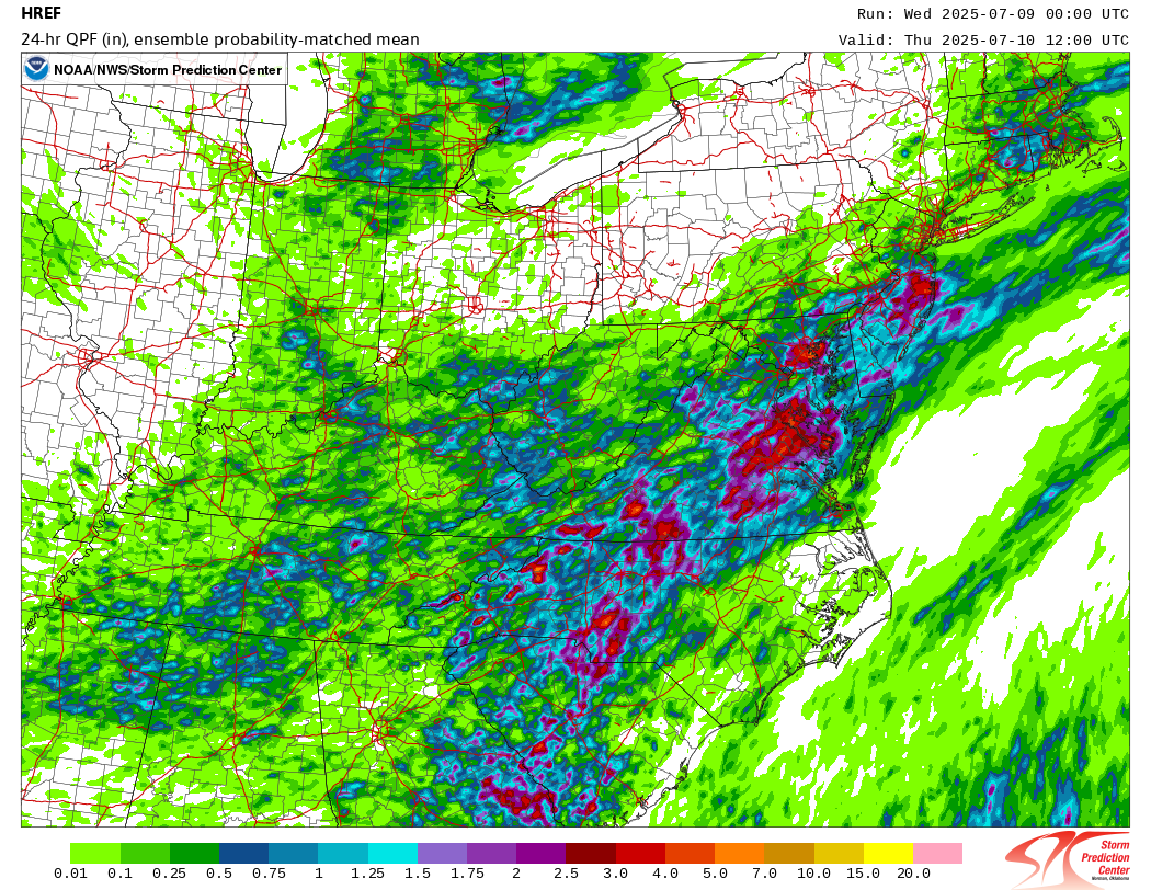
Since it seems the footprint definitely goes outside the moderate risk, folks in the slight risk areas will want to be on guard for some rapid onset street flooding today, from the Carolinas north to New Jersey. That HREF model has a thing for Baltimore today, so that may be an area to watch too. But the moderate risk area seems to have the highest probability and highest risks of seeing more widespread activity.
The risk of flooding continues into tomorrow, though the focus may shift into the Plains or Upper Midwest.
Tropics
Model support for something loosely organized continues next week in the northeast Gulf. But if we’re really being honest, there’s not a whole heck of a lot to zero in on at this point. It’s currently just a small signal among some white noise. No news is good news.
Excellent coverage of the tragic flash floods in the Hill Country. Thank you so much for providing the facts. Today I learned that cloud-seeding in that area occurred on July 2. The company said their chemicals are “safe” and did not impact the flash floods. IMHO, this flies in the face of logic. It also raises numerous questions, so I am bringing these to the pros.
Are weather forecasters notified when any cloud-seeding is happening in an area?
Since weather forecasters knew and warned about the system from Mexico heading to Texas, did the cloud-seeding exacerbate the situation?
Thanks so much for all you do to keep us aware and safe.