Headlines
- Tropical Storm Debby is intensifying, and will soon reach hurricane strength
- A landfall will occur on Monday, in the coastal bend area of Florida, with a strong surge only slightly less than that of Hurricane Idalia
- Significant rains and winds will spread over much of the northern half of Florida on Monday
- From Tuesday onward the focus turns to the Atlantic coastal regions, from Jacksonville north through South Carolina, with the threat of very heavy rainfall
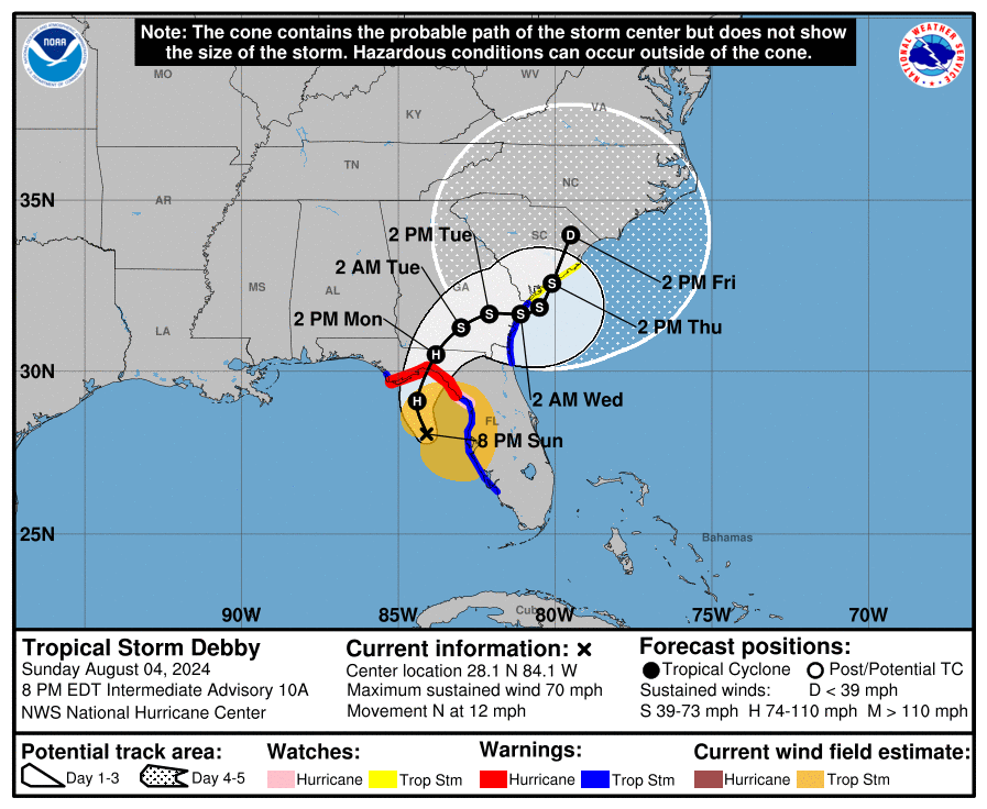
Debby status at 8 pm ET Sunday
As of this evening, Tropical Storm Debby is nearing hurricane strength with 70-mph sustained winds. It likely will reach hurricane strength tonight, and then continue to intensify before making a landfall somewhere in the parklands along the coastal bend of Florida on Monday. A hurricane warning is now in effect for the Florida coast from the Suwannee River to Indian Pass.
Immediate threats to Florida
Debby has lashed the west coast of Florida for much of the weekend, bringing heavy rains, tropical storm-force winds, and bands of rainfall to the Sunshine State. The storm has more or less been moving north for much of Sunday, and that will not change a whole lot overnight before the storm makes a slight northeastern turn towards the coastal bend of Florida on Monday. The storm will bring three major hurricane threats to the Florida coast tonight and on Monday.
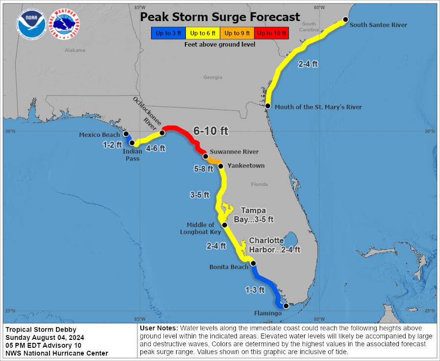
Storm surge
As Debby has strengthened and grown larger today, it is likely to produce a more potent storm surge. Nearby residents will well remember the surge of Hurricane Idalia, a more powerful hurricane that made landfall a little more than 11 months ago in a similar location. Although Debby’s storm surge will not be as potent as that of Idalia, it will nonetheless be significant. Forecasters from the National Hurricane Center now anticipate a surge as great as 6 to 10 feet from the Suwannee River northward to the Ochlockonee River at high tide.
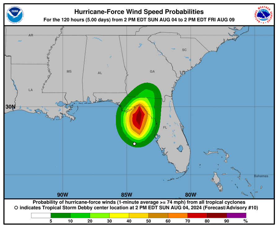
Winds
Hurricane force winds could arrive at these coastal areas of Florida as early as Monday morning, with tropical-storm force winds likely for much of the northern half of Florida, and into southern Georgia. The area of hurricane-force winds (shown in the map below) will be smaller. Such winds can knock down power poles and do considerable tree damage. The landfall of Debby is also likely to spawn several tornadoes across the northern half of Florida.
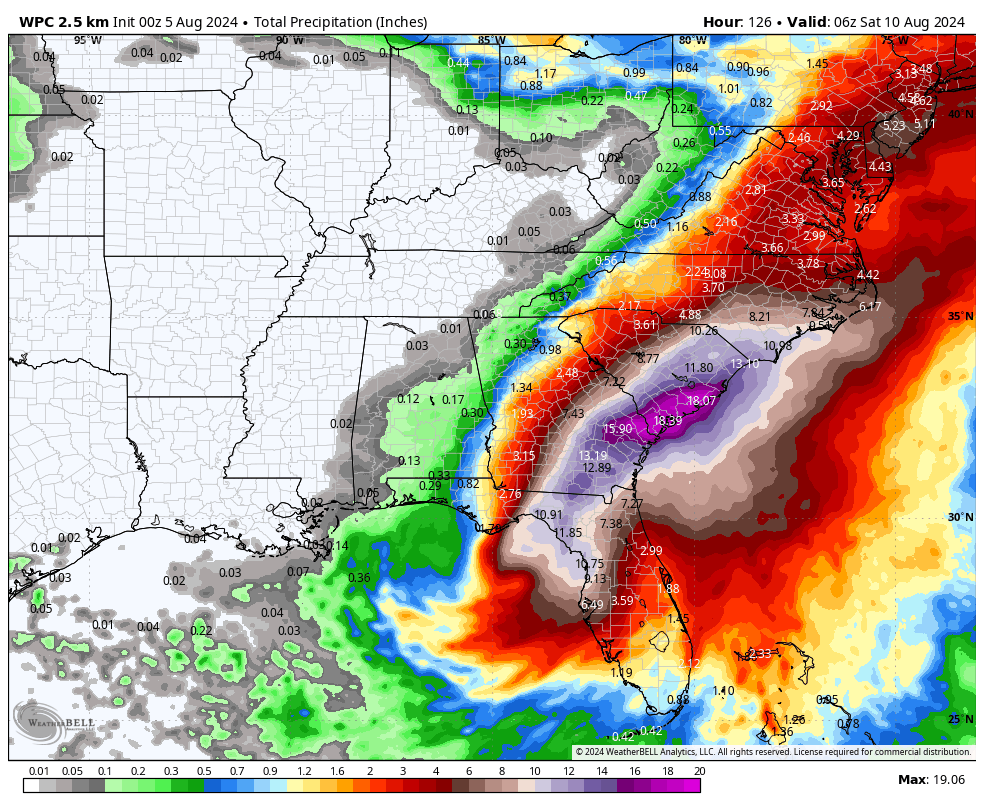
Inland rainfall
The third major threat from this storm will be heavy rainfall, which leads to flooding away from the coast. As much as 8 to 16 inches of rainfall will be possible along and north of a line from Tampa Bay to Orlando, with the heaviest showers likely along and to the immediate right of Debby’s track. Where training bands set up, there will be considerable street flooding and the potential for flooding of homes and businesses. This will compound the effects of damaging winds.
Longer-term impacts
By late Monday or Tuesday the center of Debby should be crossing through Southern Georgia, and then emerge into the Atlantic Ocean somewhere between Jacksonville, Florida, and Hilton Head Island, South Carolina. And then, it’s going to sit and spin awhile. Our latest modeling (18Z) is not helping much, but there’s a general trend toward Debby being forced back toward the Atlantic coast of Georgia by Wednesday or Thursday in response to a high pressure system building over the central Atlantic Ocean.
All of this is likely to bring some pretty serious winds and surge to coastal areas from northern Florida to Georgia and through at least South Carolina. We can be highly confident in a significant rain event for these areas, but winds and seas will depend on the ultimate track of Debby. The bottom line is that these areas should be prepared for impactful weather from Tuesday through Thursday. Hopefully, in the next day or so, we can better define the timing and the extent of these threats.
All the love to everyone in Debby’s path. Hurricane season sucks.
That yellow X in the Atlantic has my attention here in Houston. Should it?
TY
I’m pitying Eric Berger right now, imagining his life.
“Hey, Eric, Debby is still uncertain but maybe firming a bit.” “O.K., I need to put out an update.”
“Hey, Eric, there’s another anonymous source who wants to talk about Starliner.” “Um, let them know I’ll get back to them in a bit.”
“Hey, Eric, SpaceX released some really slick pictures of Raptor 3 and gave detailed performance stats. Looks like quite a story.” “I hate my life. Stephen, can you handle it?”
“Hey, Eric, did you hear what happened to Cygnus?” “Mother— goose! Can I get down to just one thing on my plate?!”
Hey, Eric, I hope you get some sleep in the next couple of days.
The GFS model has been walking back and forth, the 10-day prediction on Saturday morning’s run had a Cat 4 cane knocking on Galveston’s door, now it has nothing. Tit for tat with models 8-10 days out. Social media has a field day with stuff like this but our man Eric has taught us better than that.
It is indication though that the Gulf of Mexico is still wide open and we got another 7 weeks of this to keep our guard up.