Headlines
- Heavy rain from Debby will continue to impact South Carolina today and tomorrow.
- Heavy rain expands northward after tomorrow with flash flooding likely into North Carolina and Virginia.
- Combination of heavy rain today and Debby’s remnants may cause flash flooding in the Mid-Atlantic and New England by late week.
- The 30% area in the Caribbean continues to look middling for awhile, and it is likely to stay somewhat suppressed to the south into next week.
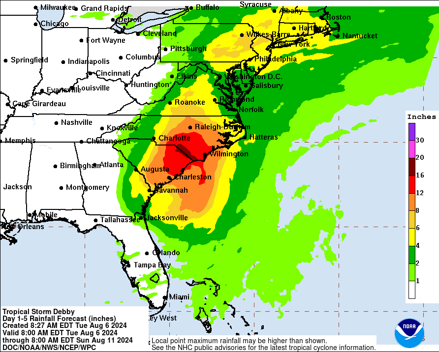
Tropical Storm Debby’s heavy rain expands this week
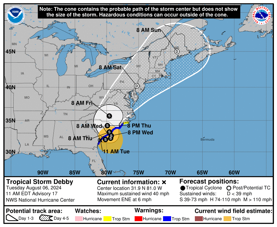
Tropical Storm Debby is still a formal entity this morning, with 45 mph winds, and it is now drifting back offshore of Georgia, where it’s expected to meander through tomorrow night. It will then likely come back onshore Thursday and lift north and finally out on Friday. But before it does that, it will continue to dump copious amounts of rain on the Carolinas with an increasing signal for flooding to the north as well. Let’s walk day by day.
Today
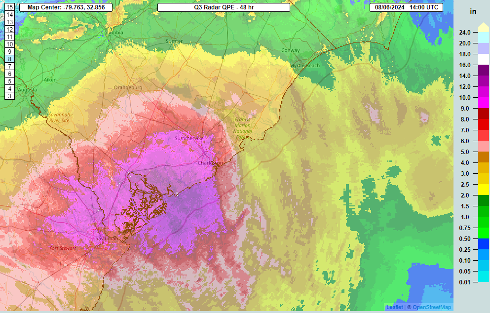
With Debby meandering offshore, expect heavy rain to basically continue in place. There will be rainfall rates of 2 to 4 inches an hour at times, mainly north of Hilton Head and south of Columbia. But, as 6 to 12 inches of rain has already fallen, flash flooding is underway, and it will continue.
As Debby drifts a little farther offshore, the rain may become a little more scattered or intermittent, but it will continue to potentially flood areas through the day. Debby should not gain much intensity today as it meanders offshore, as it will be getting its bearings.
For a look at river forecasts in South Carolina, follow this link.
Wednesday
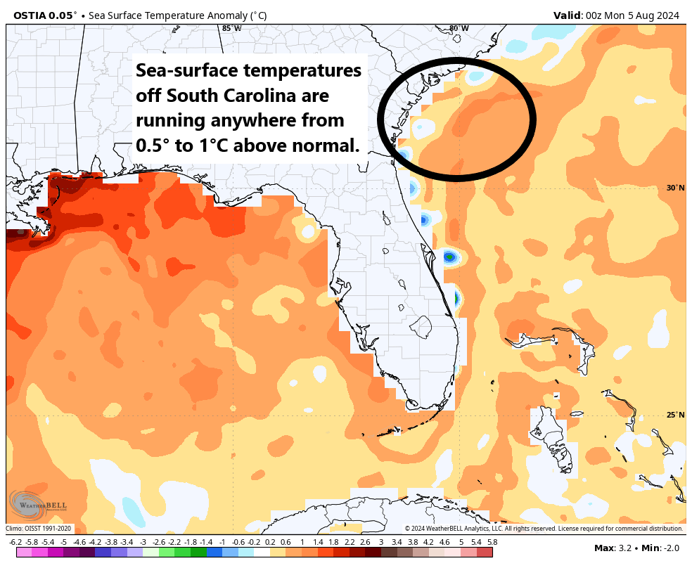
Debby will continue to meander offshore, but with generally low shear and warm water off the coast of South Carolina, it will likely begin to reorganize some. It could become a strong tropical storm again as it turns back northward toward the South Carolina coast later tomorrow.
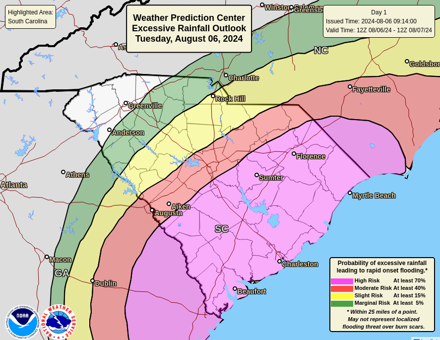
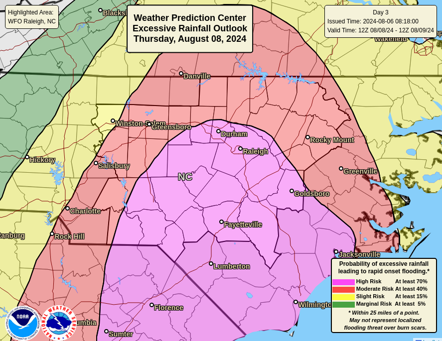
On Wednesday, the flooding threat mostly exits Georgia and is confined to South Carolina and extreme southeastern North Carolina, including Wilmington, Myrtle Beach, and Charleston. Travel on I-95 may be a bit difficult as well through the Florence area, depending on exactly where the heaviest rainfall sets up. Another high risk is in effect in this area.
Thursday
Debby should move back inland across South Carolina on Thursday. Storm surge will again be a concern (as will high tides between now and Thursday).
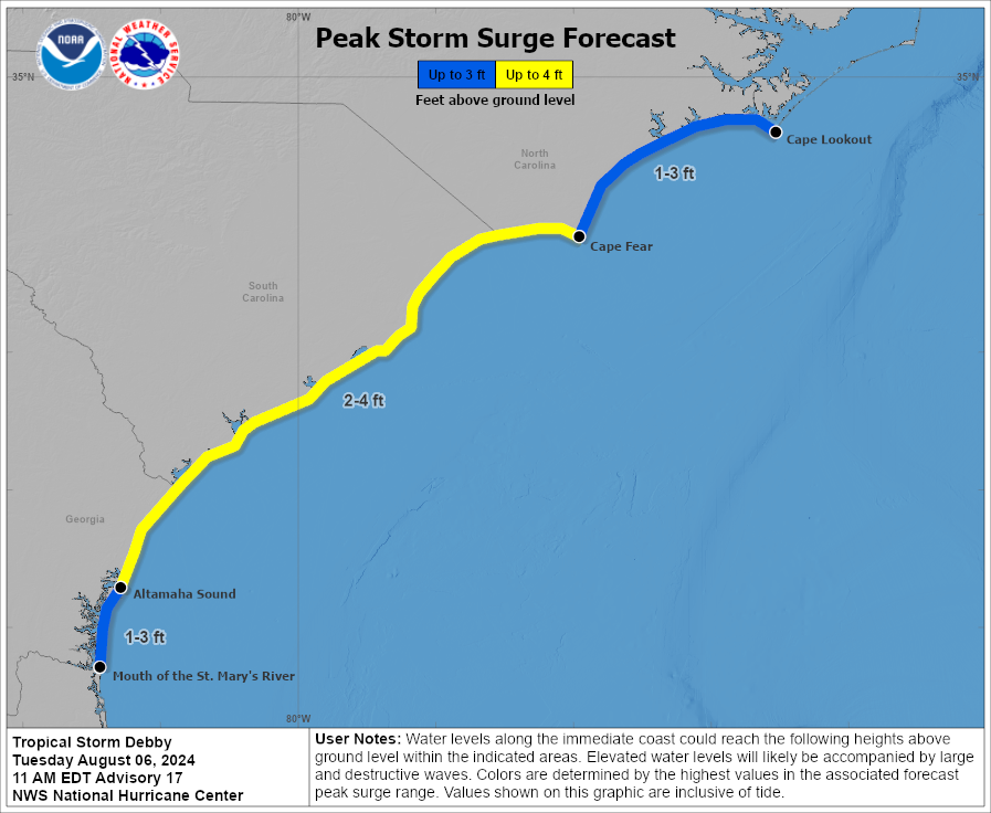
Surge of 2 to 4 feet will be possible along the South Carolina coast and possibly parts of Georgia and North Carolina as well with Debby moving around offshore and coming back onshore.
As Debby comes north a little more steadily Thursday, heavy rain will spread into North Carolina. While flooding risk will have mainly been confined to the extreme southeast corner of the state to this point, there will be a pretty significant expansion of heavy rain northward on Thursday that will engulf more of the state, including the Sandhills, the Raleigh-Durham area, and portions of the Piedmont in a moderate or high risk of excessive rain and flash flooding.
Most of the rain on Thursday will front run Debby, as the south side of its circulation will probably have lesser rain and more scattered showers. As the center gets across North Carolina late Thursday and Thursday night, we’ll see conditions slowly improve. But some serious flash flooding is a concern in both rural and urban areas of the eastern half of the state.
Friday-Saturday
Debby will continue to come northward on Friday, likely tracking across Virginia and eventually being absorbed by a trough digging into the Midwest and Great Lakes. What does this mean? Debby will become extratropical here, meaning it’ll transition from a tropical storm or depression into low pressure, a process that is meteorologically noteworthy but will have little impact on impacts seen. Heavy ran will spread across Virginia and into portions of Maryland, Pennsylvania, and New York here. These areas are expecting heavy rainfall today as well, so with soils saturated, additional rainfall from Debby will exacerbate issues.
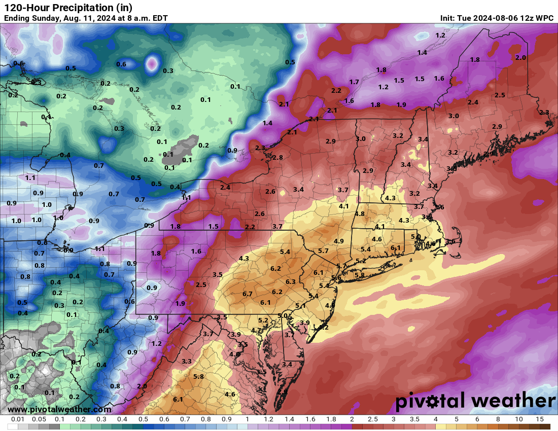
Flash flooding is likely on Friday or Saturday as Debby’s exit strategy unfolds. This may include Philly, New York, and Boston.
From here, Debby’s remnants will accelerate out, likely bringing some locally heavy rain and gusty winds to portions of Quebec and Atlantic Canada. And we can finally close the book on Debby.
Rest of the tropics
We continue to watch a tropical wave with a 30 percent chance of development per the National Hurricane Center. This doesn’t look like much today, but as it comes west it may develop.

I will say that some of the more aggressive modeling with this wave has backed off considerably in the last 24 hours, and at this point there is minimal operational or ensemble model support for any development. 30 percent seems reasonable, if not a little aggressive right now. Regardless, high pressure over Texas and South will probably keep this wave fairly suppressed and tracking toward Mexico next week. We’ll continue to watch.
Behind this, there are no other areas of interest highlighted by the NHC, but the next wave emerging off Africa is showing some signs of developing in modeling. We have about a week to watch before anything happens with that one, so we won’t over-speculate. All in all, as we get into the mid-August period, things look average. That’s good. I’m sure it won’t last, but we’ll hopefully have a couple days after Debby to exhale and regain our bearings.
I thought this was interesting, “transition from a tropical storm or depression into low pressure, a process that is meteorologically noteworthy”. Care to elaborate?
It’s mostly just a meteorological phenomenon, where the low pressure loses tropical characteristics. Tropical systems feed on warm water, warm air, and instability. Extratropical systems have more of a “cold” center and feed more off the dynamics of the atmosphere, the jet stream and such. It’s a technicality in scientific practice, but for people on the ground, no one notices this transition.
Erm, you say this could be Harvey-sized amounts of rainfall?
Likely well short of those explicit levels, but still likely to have somewhat similar outcomes, unfortunately.