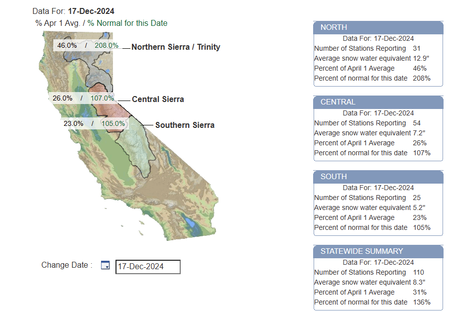
For meteorologists, winter technically starts at the beginning of December, not at the solstice which is coming up here shortly. But winter weather can happen all throughout fall too, and so far this season there’s been a bit of it around the country. We’ve seen some decent snows at times in the Sierra of California, where the snowpack is running around 100 to 200 percent of normal for the date.
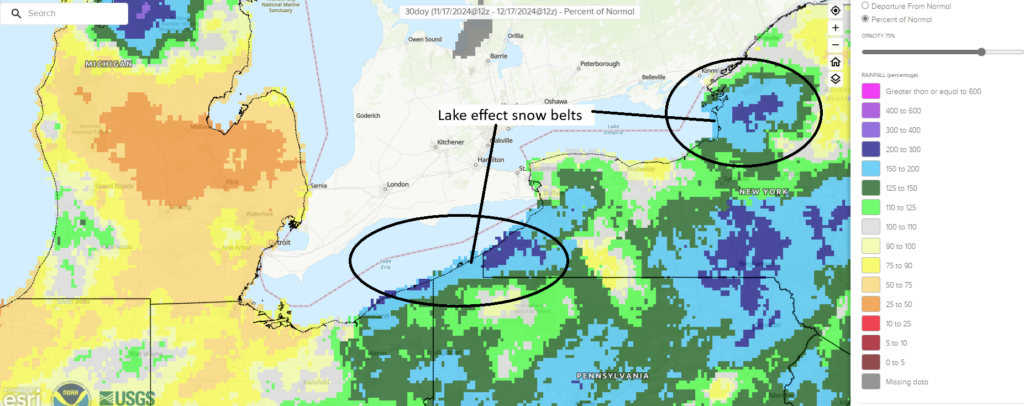
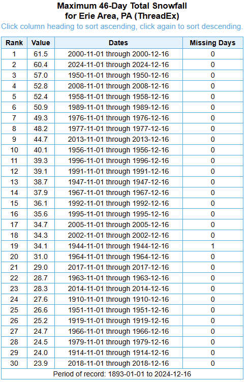
The lake effect snow belts have been crushed this year at times. Erie, PA for example is having their second snowiest start to the season since recordkeeping began there in the late 1800s.
Many people think of Buffalo being the lake effect magnet, and it is at times, but the wind direction has definitely favored some of the Pennsylvania and southwest New York snowbelts. Precip is running about 150 to 200 percent of normal over the last 30 days in Erie versus 75 to 100 percent of normal in Buffalo. You can also see a lake effect snow signal off Lake Ontario too toward Watertown and the notorious Tug Hill Plateau.
There’s been some cold at times, certainly in the northern Plains and Midwest and Northeast. But also the Intermountain West has been chilly at times. Not their coldest start to a winter by any means, but firmly in the middle of the pack or below average.
And we’ve got another blast of cold incoming here over the end of the week and parts of the weekend in the eastern two-thirds of the country, including a modest snow event tomorrow through Friday for parts of the Plains, Upper Midwest and Lakes. More mountain snows are likely out West also. But this pattern is going to change in a very big way after the weekend. A ridge of high pressure in the upper atmosphere that’s expected to shift about two standard deviations from the mean, with even a 20 to 30 percent chance of a 99th percentile event. In other words, the ridge is going to be strong for December. As you might expect, that’s likely to lead to abnormal warmth.
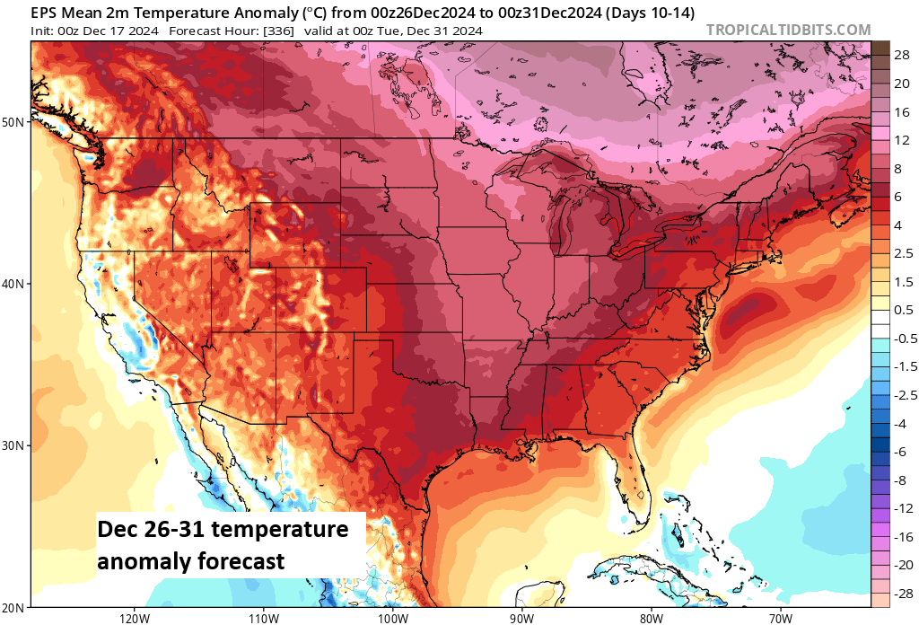
In fact, it’s not just likely to be warm, the confidence level in a warm forecast is about as good as you’ll ever see at this lead time.
CPC forecasts are not technically intensity forecasts; they’re confidence in above or below normal forecasts. That said, one could probably interpret their map shown by Brian above and the 5 day average for the 26th through 31st above it similarly. Warmer than normal and potentially much warmer than normal.
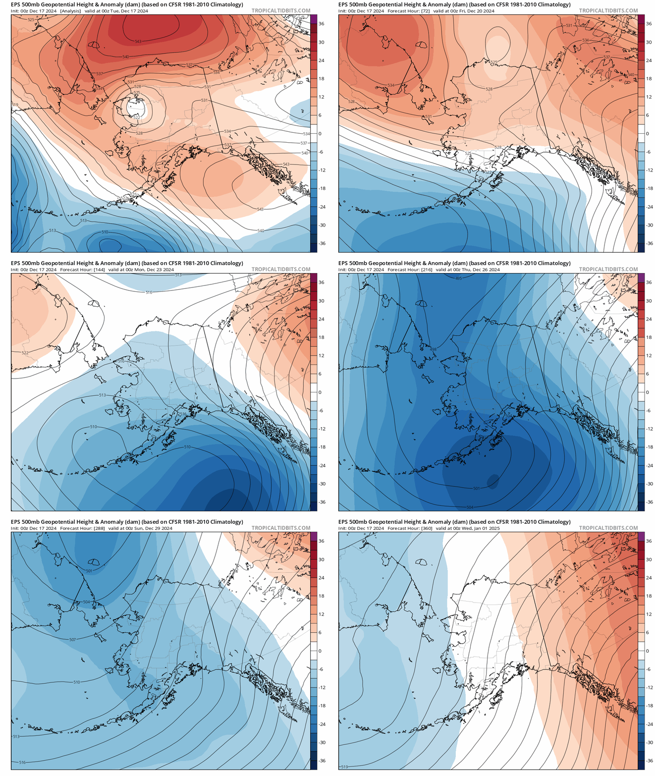
So what’s the deal? Is winter over? No, it’s December 17th. Winter is not over. However, we need to see some changes to dislodge this developing pattern next week. It would be very helpful to see the pattern over Alaska change. The animation below shows forecast height anomalies 20,000 feet up over the next 2 weeks or so. Above normal heights will often correlate to colder weather being dislodged from Alaska and northwest Canada and deposited south and east into the continental U.S. Indeed, we see above normal heights in the near-term, followed by a swift transition to deep blue, below normal heights next week. Good news for Alaskans who like cold weather. By the end of the model run we maybe see some changes over Alaska in terms of rising heights. This could help lead to downstream changes over the Lower 48, but whether that happens or not just as we cross into 2025 remains to be seen.
The bottom line: It’s more likely to be a warm Christmas than a white one in many places. Next week looks ugly for winter lovers across the Lower 48. There may be some changes by about New Years, but exactly how fast any transition back colder occurs remains very much TBD at this time.
Well, no snow for us, in Central Florida!
So, all the abundant moisture hanging around in the atmosphere will mean heavier snow for areas up North, like it meant heavier rains in the hurricanes?