In brief: Hurricane Erin is fighting off some dry air and shear this morning, which has caused it to lose intensity but maintain a large size. Forecast impacts to the U.S. East Coast are virtually unchanged today. Two tropical features in the Atlantic behind Erin are worth keeping tabs on, but none looks to be a serious land threat at this time.
Hurricane Erin
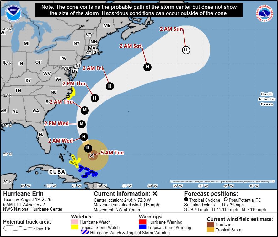
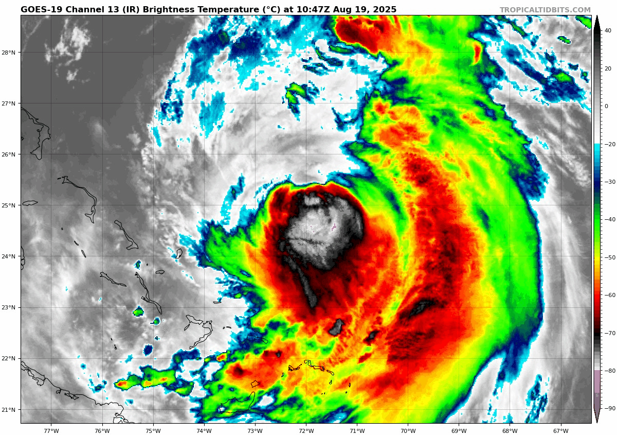
Erin has finally hit a bit of a wall since last night in terms of intensity. Maximum sustained winds have dropped to 110 mph. Where Erin has not hit a wall is its size, which remains quite large. For the U.S. East Coast and Outer Banks in particular, this means little has changed since yesterday.
We’ll get the easy part out of the way quickly this morning. Erin’s track forecast remains pretty solid with very little model spread over the next 3 to 4 days as it turns north and eventually northeast. Track forecast confidence is probably a bit higher than usual at 4 days of lead time. There’s a little more spread in the guidance once it gets south of Newfoundland, but all modeling currently keeps it well offshore.
Erin’s intensity forecast is a little trickier. Given the look this morning, with dry air wrapping into the storm and exposing the core, I have to think that Erin is embarking on a long road down. We could see some reintensification once Erin starts to pick up a little more speed. But I think the question is how much weaker it gets in the near term. Erin isn’t in a hurry right now, and it may be churning up relatively cooler water underneath the ocean. Between that and dry air, it’s just flat at this time. Whatever the case, Erin is likely to remain somewhat flat today, with some chance of reintensifying tomorrow and Thursday as it marches north. Erin will then slowly transition into a non-tropical (extratropical) storm by late in the weekend and it begins to accelerate out to sea.
Erin’s impacts remain mostly unchanged. We’ve now got Storm Surge Watches and Tropical Storm Watches on the North Carolina Coast.
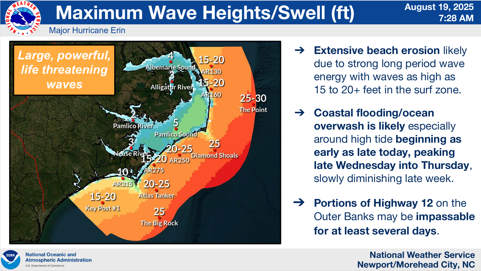
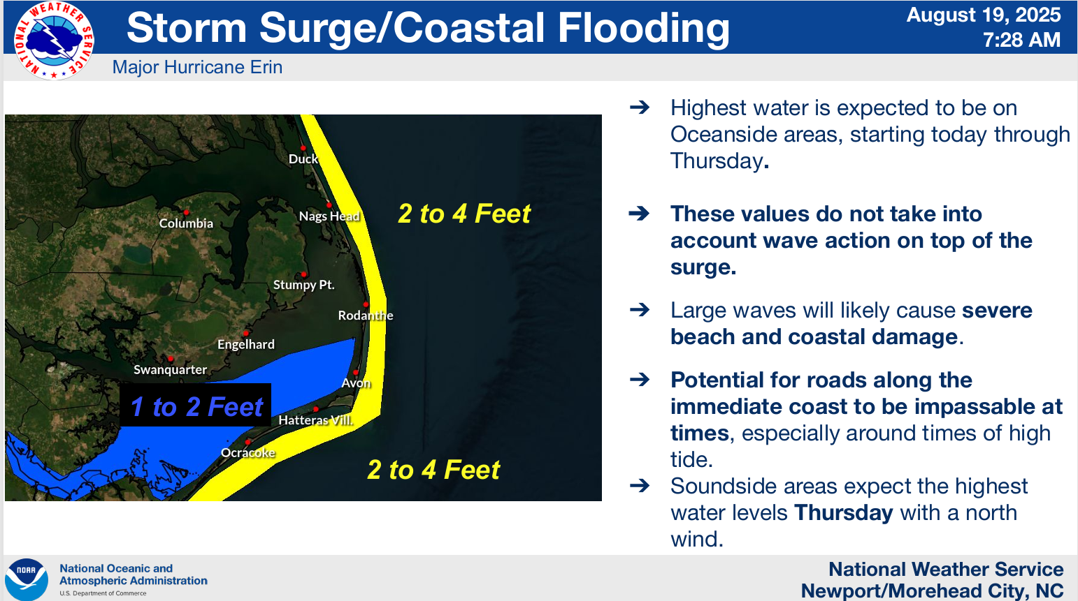
Wind gusts of 50 mph will be possible on the Outer Banks and in Pamlico Sound. The wave action and higher tides will be what causes extensive damage, likely damaging vulnerable coastal buildings and perhaps even Highway 12. While the surge forecast itself is not eye-popping (2 to 4 feet), in this area, when combined with the waves, that’s more than enough to cause damage. North winds will peak Soundside flooding on Thursday.
As we’ve been hammering since the weekend, in addition to the storm impacts on the Outer Banks, waves, tidal flooding, and rip currents are going to impact much of the Eastern Seaboard, causing beach erosion and making swimming challenging, if not dangerous the next several days.
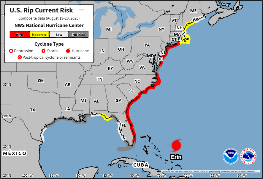
Rip currents kill over 100 people each year. These are avoidable deaths. Please heed all flags and warnings this week.
Wave trailing Erin + Invest 99L
Looking at satellite this morning, it’s kind of interesting that the wave we’ve been monitoring for the last few days looks far less impressive than the new one behind it. In fact, that wave near the Cabo Verde Islands is termed Invest 99L. For those curious, now that we’re at Invest 99L, we will recycle the list of Invests. So whenever the next system comes around, it will be tagged 90L. It’s entirely possible that the wave ahead of 99L gets tagged 90L at some point. Whatever the case, here they are.
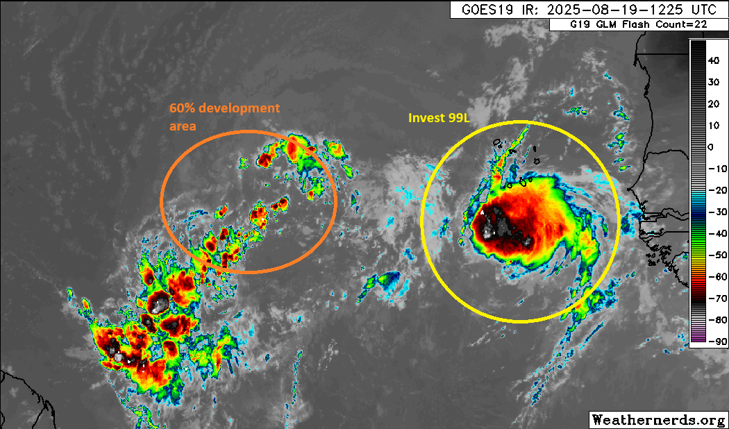
Over the next 2 to 3 days, it is expected that Invest 99L will actually weaken, while the wave in front of it will actually strengthen. As the leading wave strengthens while moving west, it will probably begin to get drawn into the weakness in upper-level ridging left behind by Erin. You can see that by looking at the upper-level weather map on Thursday evening. The leading wave is approaching the islands. Between Erin’s proximity to the north and the weakness in upper ridging left behind, this wave should turn northwest near the islands.
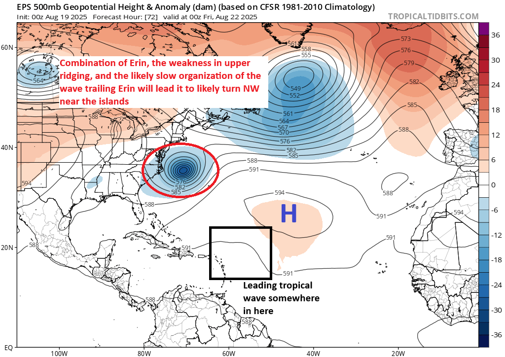
Both AI modeling and the Euro ensemble members today favor a sharper turn north, which would draw it on a track east of where Erin is going. I would say this is worth keeping an eye on for the islands and for Bermuda at this point. A long way to go still with this one.
So what about Invest 99L? Well, I’m always leery about waves like this one. As noted above, it should begin to fall apart in a day or two, so any development risk is short-lived in the near-term. But because it falls apart and stays relatively weak or undeveloped, it’s likely to sneak under everything going on to its north and west. This means it will probably ultimately find the Caribbean. From there, it’s anyone’s guess, but interestingly, virtually all modeling (except the GFS operational of course) basically keeps the wave a suppressed, weak feature into Central America. Either way, it’s at least 10 days from probably doing anything, so we have plenty of time to watch and it’s nothing anyone needs to worry about right now.