Headlines
- Hurricane Ernesto delivering torrential rain and flooding to Puerto Rico.
- Ernesto will continue to pull away north of the Caribbean, relaxing impacts there.
- The hurricane will track toward Bermuda for late week and this weekend, coming very close and likely delivering considerable impacts there.
- Beyond Bermuda, it appears there is an increasing risk for a direct impact in the Canadian Maritimes next week.
Hurricane Ernesto chugging away from the Caribbean
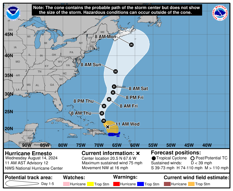
After moving through the Virgin Islands and to the north of Puerto Rico, Ernesto has become a hurricane today with maximum sustained winds of 75 mph, the third hurricane of the season. While the hurricane winds will remain comfortably north of the Caribbean islands, there are many power outages and heavy rainfall remains a big problem in Puerto Rico, which is just getting dumped on today in the wake of Ernesto.
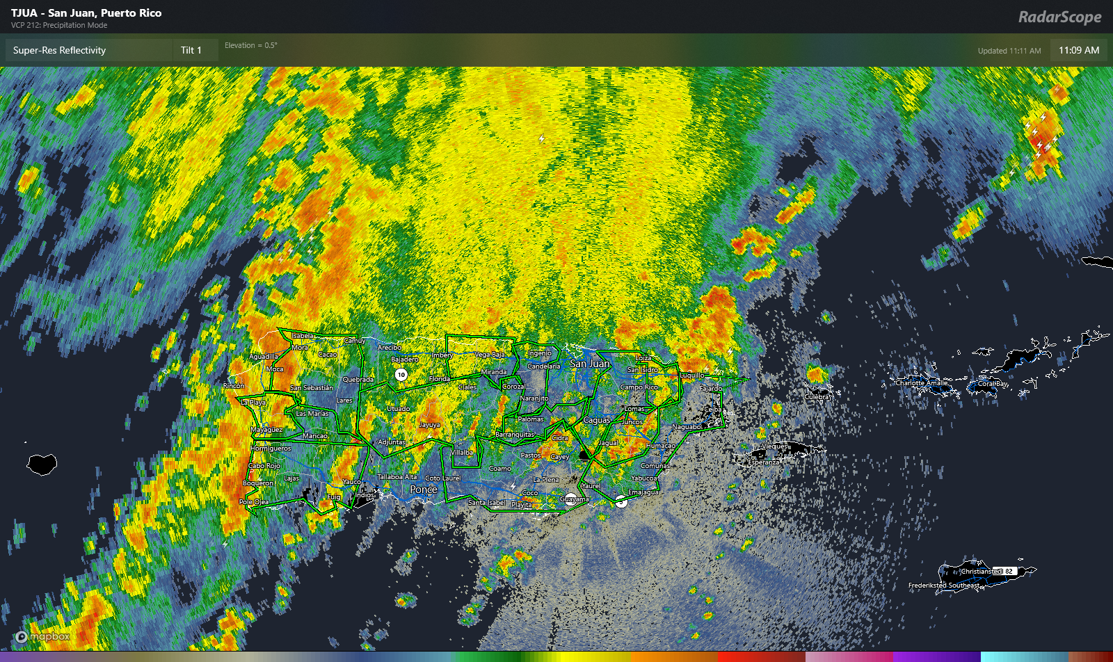
Upwards of a dozen flash flood warnings are in effect on the island, covering just about every corner. Rain totals are estimated around 8 to 10 inches in the south-central portion of Puerto Rico in the last 24 hours, with another 3 to 6 inches possible before all is said and done.
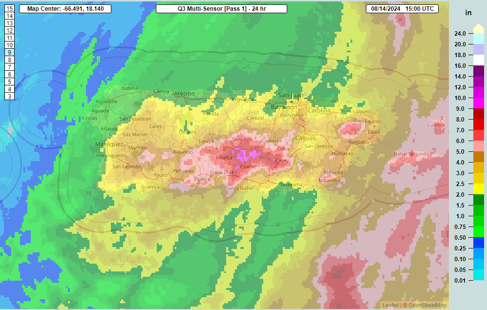
Considerable flash flooding and localized mudslides will remain a threat into late afternoon and evening in Puerto Rico and to a lesser extent the Virgin Islands.
Meanwhile, Ernesto is moving northwest at 16 mph, hauling its way away from the Caribbean. The next question will become how close it gets to Bermuda on Saturday. Ernesto split the gap between two high pressure centers over the Deep South and Atlantic Ocean, and it will follow that gap into a trough off the East Coast. The trouble starts to happen on Friday as Ernesto is moving northeast toward Bermuda. The trough is going to exit the picture, likely leaving Ernesto behind.
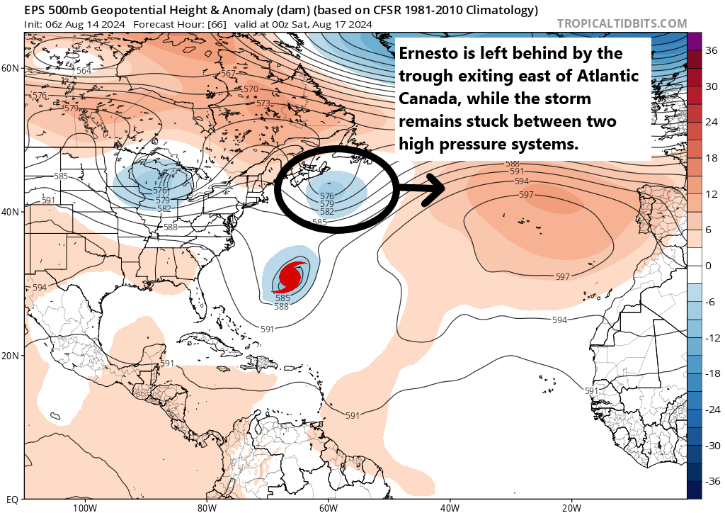
Ernesto will begin to slow down at this point, since it will lose the “pull” of the trough. This should allow it to lash Bermuda with heavy rain and gusty winds. Ernesto may be a major hurricane at this point, or at least close to it, so it will probably deliver some pretty meaningful impacts to the island, of course depending on exactly how close it comes.
Ernesto may then get “pulled” back to the northwest a bit by an approaching trough from the Great Lakes. It’s not going to make a hard left into the U.S. East Coast, but this will delay its exit out to sea. At the least, rough surf and rip currents will likely become an issue this weekend and next week on the East Coast. From a land impact perspective, this erratic movement has implications for Nova Scotia and Newfoundland. Instead of exiting into the open Atlantic, the jog back north or northwest could allow Ernesto to eventually smack into Atlantic Canada next week. The exact details and impacts of this are TBD, but suffice to say, I would be watching this closely in the Maritimes.
More to come on this. Meanwhile, the Atlantic continues to look as if a suppressed background state will halt tropical development risk for the next 7 to 10 days behind Ernesto. No additional storms are expected through next week.