Headlines
- Invest 97L has reached Cuba, and will near the Florida Keys by Saturday
- Our confidence in its track is increasing, raising the risks to Florida, and lowering them for the northern Gulf of Mexico coast
- All tropical threats are in play, but we’re most concerned about heavy rainfall at this time
- Risks are also rising for the southeastern United States, particularly coastal regions of Georgia and the Carolinas
Status of Invest 97L
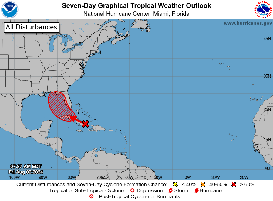
The tropical wave we’ve been tracking continues to get better organized, and it now has the designation Invest 97L. The approximate center of the system is now near or over the eastern end of Cuba, and it should move along the island today bringing showers and thunderstorms to Cuba and other Caribbean islands. Interaction with land may limit any attempts to organize today, but by Saturday it should emerge near the Florida Keys and move into the southeastern Gulf of Mexico. At this point the National Hurricane Center gives the system a 90 percent chance of eventually becoming a tropical depression or storm. In this case it would be named Debby.
Forecast clarifies some
If you read our update on Thursday, you’ll recall we were in “watch-and-see” mode with this tropical system. Well, we’ve watched. And now, we’ve seen. All of our major model guidance now predicts that 97L will move into the southeastern Gulf of Mexico, and likely remain near—perhaps just offshore—the coast of Florida on Saturday and Sunday. During this time it could well strengthen into Tropical Storm Debby, but this is not sure thing as I don’t know how disorganized 97L will be when it moves off of Cuba.
At some point this weekend, perhaps on Sunday, or Sunday night, 97L is likely to turn toward the northwest. This could bring the system into Florida anywhere from south of Tampa Bay to the coastal bend of Florida. A stronger storm would likely turn more quickly. In any case, residents of the Florida Keys and the West Coast of Florida should be preparing for tropical weather as early as Saturday.
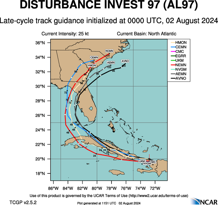
After 97L crosses the Florida peninsula it may reemerge into the Atlantic Ocean somewhere near Jacksonville, Florida. At that point its center should remain just inland, or perhaps move offshore before moving into South Carolina or North Carolina as a stronger storm. East Coast regions from Jacksonville north to coastal Carolina and possibly even Virginia should be prepared for tropical impacts from Monday through Wednesday of next week.
We mentioned that residents of the northern Gulf of Mexico coast should remain vigilant in yesterday’s post, but at this point all of our guidance suggests the storm’s impacts will occur from the Florida Panhandle and to the east.
97L impacts
So far we’ve mentioned that coastal residents in Florida and up the East Coast should prepare for tropical weather, because all of the impacts associated with a tropical system are in place: strong winds, storm surge, and inland rainfall. The extent of these impacts will depend on how much 97L strengthens before moving into the west coast of Florida, and then whether it has time to restrengthen over the Atlantic Ocean if it spends time offshore of Georgia and the Carolinas. That is impossible to forecast at this time, and probably won’t be until 97L develops a better defined center of circulation.
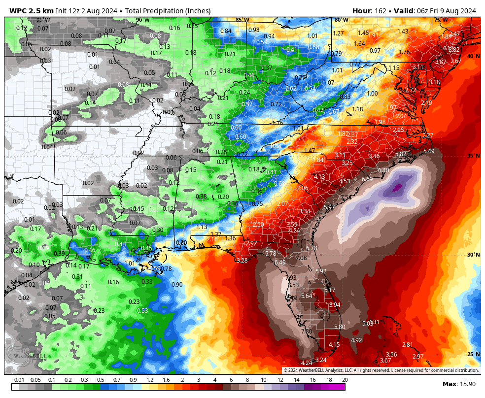
The one bit of good news is that it now appears that this tropical system will probably miss an area of low steering currents over the northern Gulf of Mexico. This means that its track should be more conventional, first turning north, and then to the northeast as it moves poleward. This should help to limit rainfall totals, but some of our models are still showing very high amounts in coastal areas of Western Florida and coastal Carolina. Again, these totals will depend on the location and forward speed of the storm this weekend and during the first half of next week. Regardless, flooding is a concern.
Elsewhere in the tropics
Beyond 97L, as we get deeper into August, there is likely to be some activity over the next week or 10 days. At this point the area of greatest interest may be the southern Caribbean Sea, where something may spin out of the gyre in that region next week. We shall watch and see what happens.
I don’t remember seeing a named storm starting with “C”. How did we get from Beryl to Debby?
Carlotta is currently churning off Baja California.
Carlotta is actually a Pacific storm that has its own names. Chris was the Atlantic TS that formed just off the coast of Mexico and moved inland and dissipated quickly.
Tropical Storm Chris formed on June 30th (after Beryl) while we were watching Beryl race across the Caribbean and moved ashore into Mexico the next day.
From the weather channel:
That’s because we already had a “C” storm, although it was done in by a lack of punch and bad timing. Chris was a short-lived tropical storm that made landfall in eastern Mexico late on the night of June 30, in the midst of Hurricane Beryl’s interaction with the Windward Islands and eastern Caribbean.
With Beryl hogging so much attention, Chris apparently got missed by a lot of people: We noted an unusual amount of search activity this week around the term “Hurricane Chris”, a storm that never was, and isn’t coming – at least, not this year.
Great analysis 😀
I was wondering about that GFS Caribbean disturbance: another waiting game.
The 12Z GFS has something to watch
It’ll change.
Thanks for your clarity! We here in SWFL appreciate the no drama mode! ✌🏼
Port richey,fl residence prepare for tropical storm warning low line will evacuate those who choose to goo luck I’m staying Debby 2nd will come and go.
what happened to the first name that started with A & why no Chris? very much hope everyone in Florida will be okay
The first storm was Tropical Storm Alberto, which made landfall in NE Mexico in mid-June. Chris was a short-lived Tropical Storm that made landfall near that same area, at about the time that Beryl was rolling through the Caribbean in early July (Beryl was taking up all the headlines at that time, so Chris didn’t get much attention).
Could this current storm be a *good* thing for us w/re to the potential system in the Southern Caribbean? I have read/heard more than once that as storms churn the Gulf’s waters up, they cool (deeper water rising to the surface) which could weaken anything coming along behind it. Or does that effect not last long enough to be material?