Headlines
- Francine will likely produce flash flooding, particularly in Alabama and Tennessee over the next couple days.
- We recap Francine below with info on how AI modeling did and why New Orleans saw worse conditions than expected earlier in the day.
- The Atlantic looks more active than it actually is, with two invests that should not develop and one depression that may become a named storm and stay out at sea.
- A subtropical or tropical system may form off the Southeast coast next week.
Thanks to folks in Louisiana that followed along with us through Francine, and we hope you’ll spread the word and stick with us. We did experiment with a new format yesterday by updating the AM post instead of pushing new posts all day. Any feedback is appreciated.
Francine recap
With Francine down to depression status and dissipating, I want to just point out a couple odds and ends related to the storm.
Current forecast
The rainfall forecast for the rest of the week is pretty stout in the Southeast, with as much as 6 to 8 inches of rain possible across portions of Alabama and Tennessee.
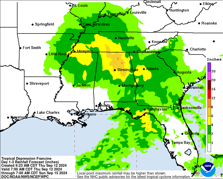
Flash flooding and localized severe weather will be the primary impacts of Francine’s remnants over the interior. A good idea to remain weather aware, particularly between Birmingham and Huntsville due to flooding.
AI modeling & ICON scores a big win
I went through and assessed the 15 model runs leading up to landfall from various models with Francine. Keep in mind that the landfall point is not the only variable that matters, but it’s an important one. And one thing you cannot tolerate as a forecaster is a lot of whipping around within the models. Enter the European AI model, the AIFS. Here are the 15 runs leading up to landfall with Francine:
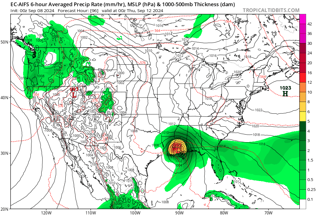
This is a remarkable feat of stability. The AIFS showed landfall between Vermilion Bay and Grand Isle run after run after run. Ultimately, it came in on the eastern half of that spread, but the consistency was some of the best I have ever seen with respect to a tropical system. The timing and intensity bounced around a bit, but not so much as to make the tool useless. It had immense value, and it’s one of the reasons we were very bullish about this not being a serious Texas concern. This was a lesson learned from Beryl. And not to be outdone, the ICON also showed a healthy amount of stability run to run in terms of track.
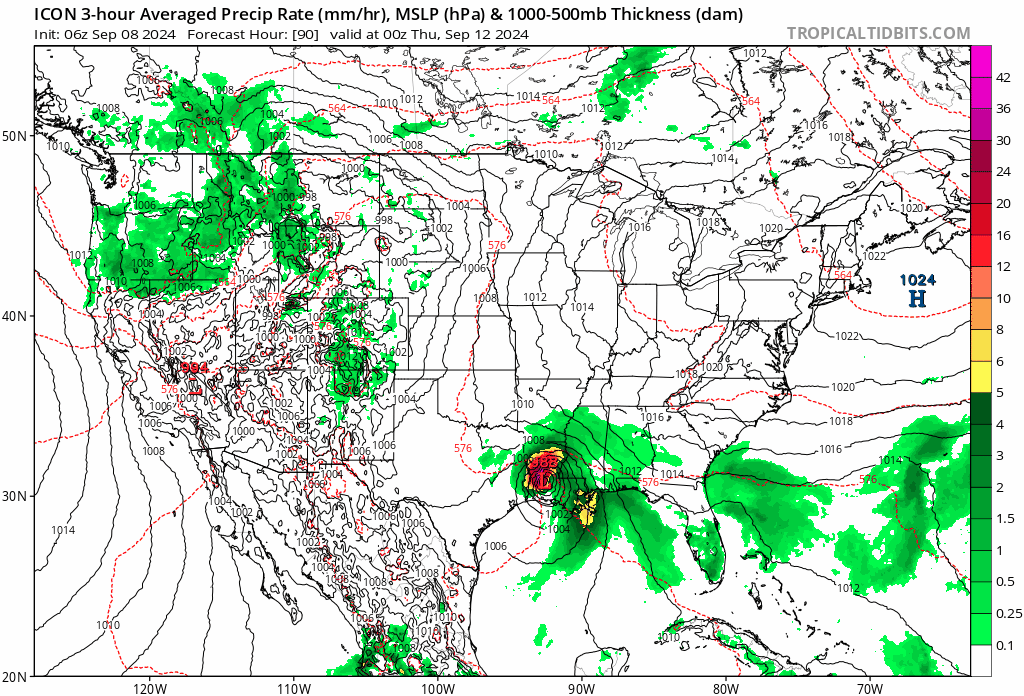
While the ICON kept western Louisiana in play for a while, it too corrected east in time. This, combined with its performance during Beryl (as well as last week with Invest 90L) made it another valuable tool. Will these models fail in the future? Yes, all models do. And the ICON remains prone to spurious tropical systems that never end up happening. But at this point, I think there’s a lesson to be taken from this as a meteorologist. particularly when the models show this sort of stability. The GFS and Euro operational model (and the ensemble guidance) also performed respectably, but those models showed less consistency run to run than did the ICON and AIFS.
Last minute lurch to New Orleans
In yesterday’s morning post, we noted the forecast for New Orleans showed maximum wind gusts forecast to be 57 mph. They gusted to 78 mph. The reason was twofold. First, the storm had a quick late burst of intensification (in the face of wind shear no less) on approach to landfall. This led to an eastward shift at the last minute. Instead of coming in right at Atchafalaya Bay, it came in a more of a slanted angle just east of there. This, coupled with the stronger intensity pushed the eyewall into the New Orleans metro area leading to wind gusts of 60 to 80 mph. Hurricane forecasting remains imperfect.
Of note, thus far the highest wind gust I have seen is 96 mph in Dulac, LA. There were two 100 mph gusts south of Burns Point, LA, but those I believe were on elevated oil platforms which would have higher winds than at surface level. The highest rain total was in Mandeville, at just over 9 inches. New Orleans saw over 8 inches in the city. Officially, they reported 7.33 inches at the airport, the 9th wettest day on record there.
Atlantic action amplifies
Turning our attention back to current matters, let’s take a look at the Atlantic this afternoon.
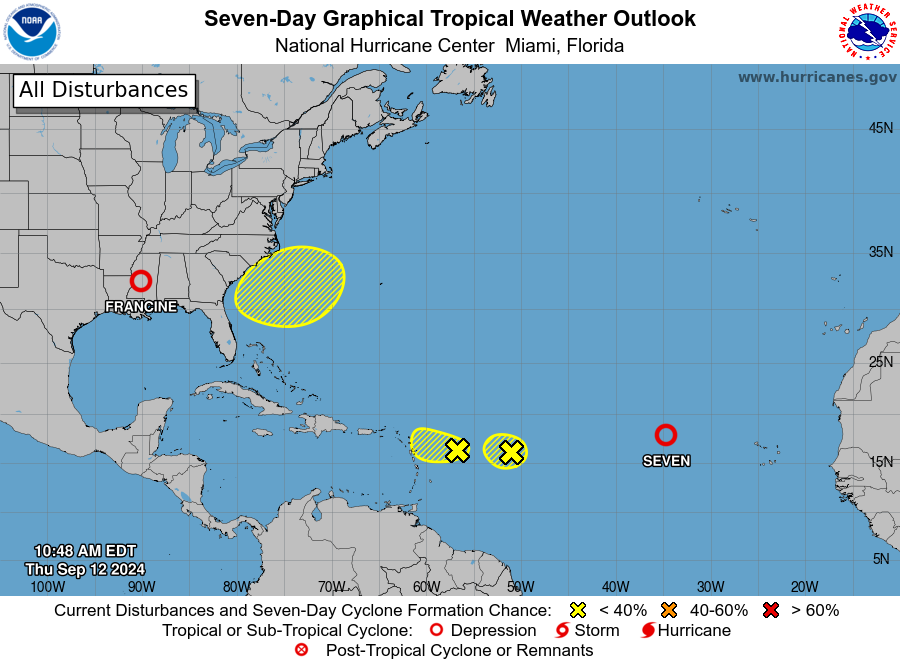
There are two invest, a tropical depression, and an area to watch in the Atlantic today. We’ll cover the area to watch below. But in the meantime, Invests 92L and 94L just east of the Caribbean are not really of any concern. Those should dissipate before acquiring the ability to develop. So nothing to see here right now.
Meanwhile, Tropical Depression 7 will probably make an attempt to become Tropical Storm Gordon, which somehow hasn’t been retired, despite being used since 1994 in perhaps its most memorable iteration. But Gordo will probably remain out at sea.
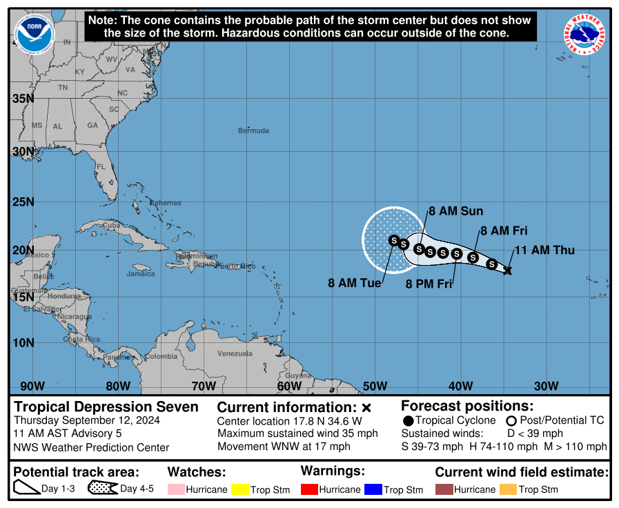
Otherwise, the Atlantic is quiet for now.
Southeast system next week?
Things may get interesting next week, to an extent, off the Southeast coast as a remnant cold front could help spawn a disturbance off the Florida, Georgia, or South Carolina coast.
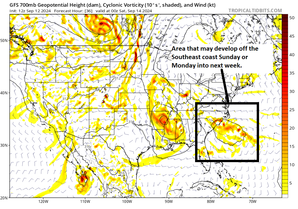
Exactly how this evolves is a bit tricky since remnant fronts tend to be a little difficult to exactly predict. But in general, watch for a disturbance to form off the Southeast coast. Because it’s forming from a front, it would probably be non-tropical or “subtropical” in nature. It may have some time to develop into a tropical system over the Southeast coast’s warm waters early next week before likely coming ashore somewhere in the Carolinas. Intensity-wise, it’s a bit early to get too cutesy, but this would probably be slow to organize and develop, so it would probably be a tropical storm at most. But regardless, watch for heavy rain risk next week in the Southeast due to this system. More to come.
We will leave it there for now, but tomorrow we’ll talk a bit more about the longer-range and why things may start getting busy again by the end of September.
I like the updated format. Feels more put-together.
Ty for the info – it was surprising that Francine intensified in the literal face of wind shear.
One issue I have with updating the old post is that I get notifications in my news reader (rss) app of new posts but not of updated previously read posts.
As an RSS consumer, the update format wasn’t as useful for me, but if it benefits the masses, all the better.
It’s hard when there’s notification to keep track on what info is current and what is older.
Even before you asked for feedback, I was going to thank you for your ongoing coverage with the updates yesterday. I liked the format and thought you covered Francine’s landfall well.
I check the blog when I’m curious to do so and don’t rely on notifications, so the update format works fine for me. However, I’d be concerned this format would not work well for those who rely on notifications as some users are already pointing out. Maybe there’s a workaround for that.
I don’t envy you meteorology scientists. On one hand, you learning from the science while trying to improve the science. On the other hand you are trying to communicate realistically in real time to home and business owners about something that is possibly the worst thing that could happen to them and their families. You might need Steve Jobs to sort through the assimilation of consumer needs & dissatisfactions, needed features of service and emerging technology. Just food for thought this morning. Thank you for all that you do, truly!!!
Thank you for what you do!! You are my go to daily weather and hurricane watch guys!
It concerns me how often storms lately have been undergoing a sudden increase in intensity that was not expected. How is it there is enough energy in near shore waters?
If this hurricane season turns out to be a bust, it would be very interesting to see an in depth post on why you think it was a bust, and it seems that there may be a number of factors involved. Something I read earlier in the season (don’t remember the source) mentioned how climate change may be affecting the upper atmosphere, making it warmer and possibly supressing hurricane formation since hurricanes need colder tops. This year has certainly thrown us some weather surprises. I was surprised to see the last minute intensification of Francine WITH wind shear.
I forgot to add concerning the article I read about the upper atmosphere that I thought the opposite was true. I wish I could remember the source.