Headlines
- Francine is slowly organizing itself today and has turned NNE off the coast of Mexico.
- The storm is expected to become a hurricane tonight as it tracks toward Louisiana.
- There has been a minor eastward adjustment to the track forecast today, bringing it in on the east side of the Atchafalaya Basin.
- Watches and warnings were extended east to Mississippi and Alabama today.
- Storm surge predictions have nudged up a hair in eastern Louisiana, including Lake Pontchartrain but remain at a 5 to 10 foot peak in central Louisiana.
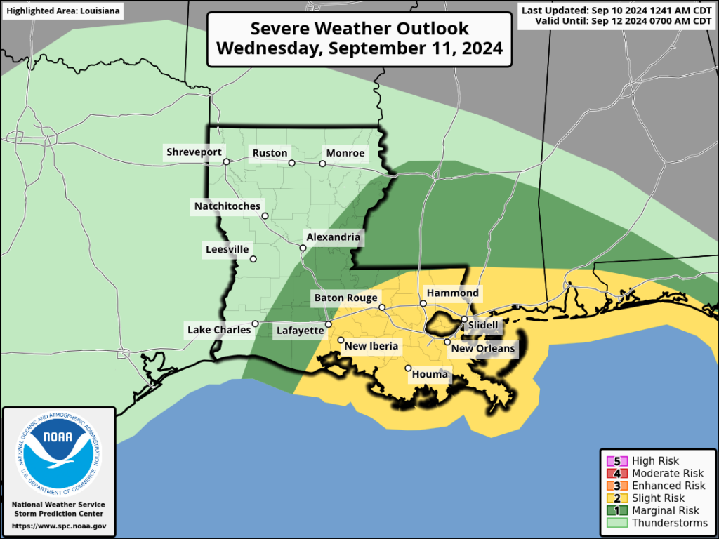
- Rain will cause areas of flash flooding across Louisiana and Mississippi in particular tomorrow.
- Isolated tornadoes are possible from Acadiana through the western Florida Panhandle tomorrow.
- No other areas of concern to land right now in the tropics.
Francine now & intensity outlook
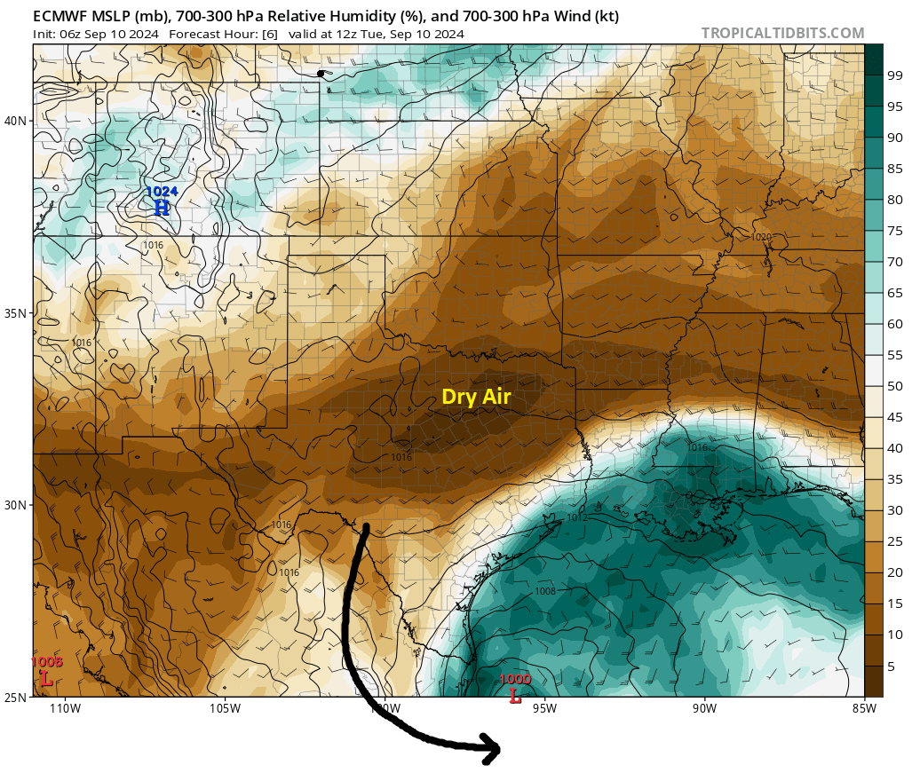
After a night of struggles, Francine is putting itself back together today and appears to be on the upswing. Satellite imagery shows a developing core that has eradicated a lot of the dry air that was inhibiting organization overnight.
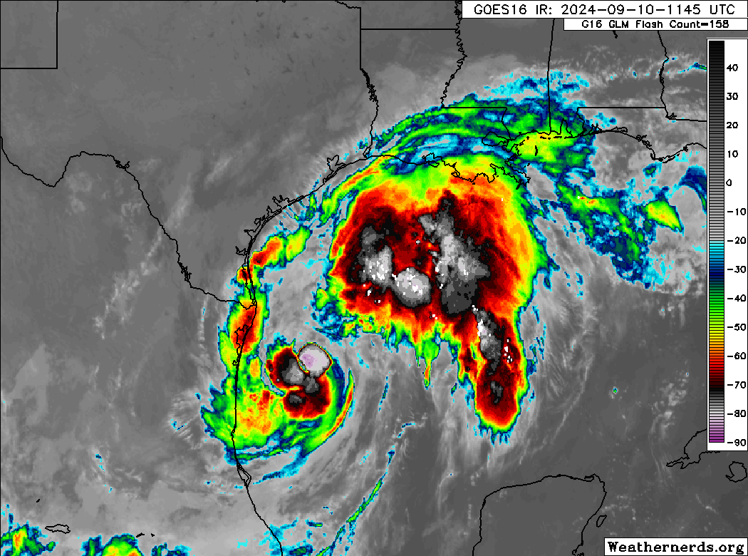
If you look at that loop above, you may be confused by “two” areas of storms. The northern most one is connected. I’m speculating that it may be a predecessor rain event (PRE) due to jet stream interaction downstream of the storm itself. What you should focus on in terms of judging the storm is the core off the coast of northern Mexico, and that’s what’s gradually picking up today. I will say, there is ample dry air over Texas and the Deep South that could continue to impact Francine in some capacity. If the core can close off from this, it has a 12 to 18 hour window to perhaps rapidly intensify before that dry air almost certainly gets involved once more.
In addition, Francine will encounter a wall of wind shear on the Gulf Coast that will help to weaken it quickly once inland. I don’t want to minimize impacts at all, but this will have some challenges in front of it.
So, expect Francine to become a hurricane later today or tonight. It has some chance to get to category 2 intensity, but it is likely to come ashore as a stout category 1. Either way, we’re sort of nitpicking at this point. Landfall is expected to occur tomorrow afternoon with impacts beginning in earnest later in the overnight.
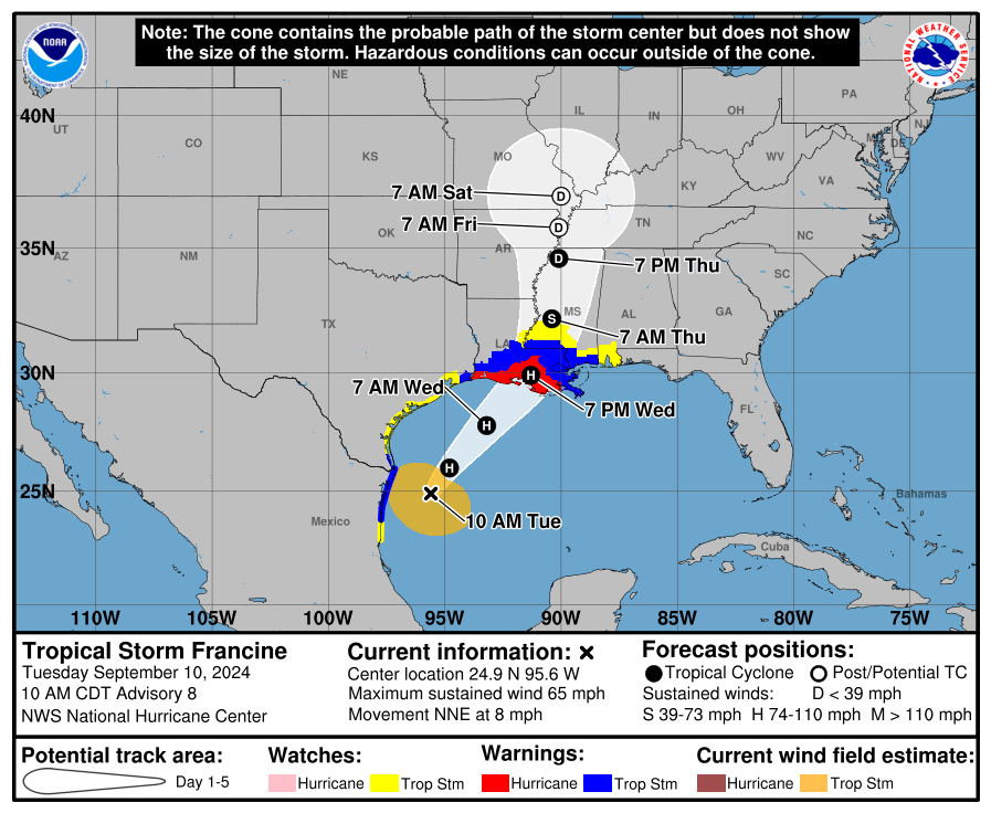
Francine’s track
The forecast track of Francine takes it on a beeline toward Louisiana. There has been some movement to the east this morning in the model guidance which brings it more toward Atchafalaya Bay. Some models even bring it as far east as Houma or Port Fourchon. As a result, tropical storm watches and warnings have been extended east into Mississippi and Alabama now. More on the winds in certain places below.
Francine’s impacts
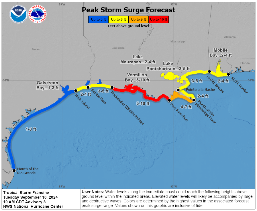
We continue to see storm surge risk from Francine peaking between Port Fourchon and Grand Chenier at 5 to 10 feet. With the latest forecast update, the surge has been revised upward to the east somewhat, with 3 to 5 feet now in Lake Pontchartrain and along the Mississippi coast. Surge of 4 to 7 feet is expected near Grand Isle to the mouth of the Mississippi River.
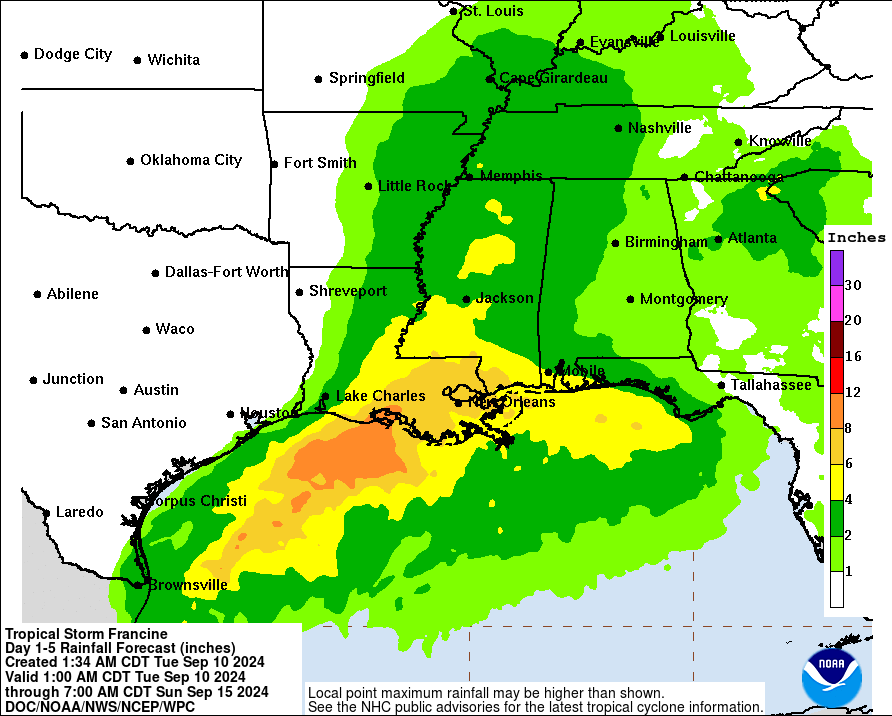
The rainfall forecast likewise has been adjusted eastward some. We now expect around 2 inches in Lake Charles to as much as 8 to 12 inches in the bays and coast of the Atchafalaya Basin. As much as 6 to 8 inches may fall between Lafayette and Gulfport northward a bit. Flash flooding is possible across southern Mississippi as well. Moderate (level 3/4) risks for excessive rainfall exist in much of those areas near where the storm comes ashore tomorrow.
Here’s a revised version of the maximum forecast wind gusts by location today based on currently available NWS forecasts, subject to change:
Houston: 25 mph
Galveston: 31 mph
Beaumont: 25 mph
Port Arthur: 37 mph
Lake Charles: 39 mph
Lafayette: 47 mph
Baton Rouge: 95 mph
Port Fourchon: 55 mph
New Orleans: 45 mph
Gulfport: 45 mph
Natchez: 36 mph
Vicksburg: 32 mph
Jackson, MS: 40 mph
Mobile, AL: 32 mph
The Baton Rouge value is because the storm is expected to pass very near there (the only major city on this list to see that) so gusts of category 1 intensity seem reasonable. This will likely cause some substantial power outages across that region between New Orleans and Lafayette. The drop off in wind to the north of there may be significant, with much less in the way of wind impacts north of I-10/I-12 than south of there.
Isolated tornado risk is a safe bet across much of eastern Louisiana, southern Mississippi, and perhaps southern Alabama and the Florida Panhandle. The region is in a slight (level 2/5) risk of severe weather tomorrow.
Other Francine notes
Houston: For our Houston readers, please see Space City Weather for the latest. There should be no meaningful impacts in the area.
Lower Rio Grande Valley: Heavy rain led to some localized flash flooding issues east of Brownsville to the coast this morning. Rain totals of 2 to 6 inches were estimated by radar.
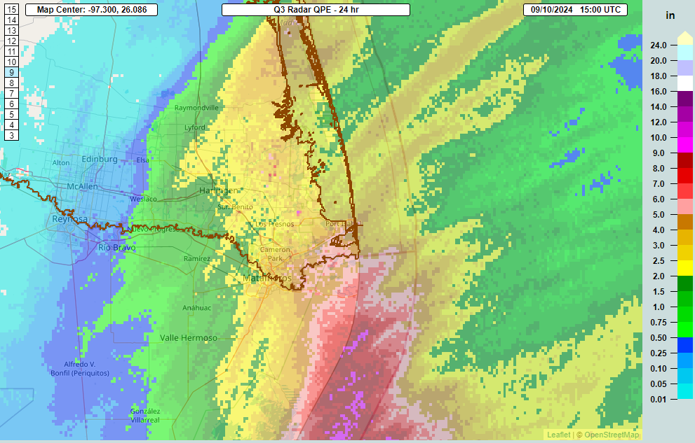
Additional rain may fall today but the worst of the flooding threat should be over here now.
New Orleans: City officials are advising residents to shelter in place during the storm overnight and tomorrow. Significant flooding impacts should not be a serious concern, but localized flooding will likely occur around the city and metro area. Follow local officials in southeast Louisiana and NOLA Ready for the latest local information.
Elsewhere in the tropics
We haven’t been ignoring the rest of the tropical Atlantic, but there’s not a lot to worry over right now. Invest 92L has about a 40 percent chance of developing over the next few days, which is down somewhat. The next area to watch east of there is up to 70 percent over the next week, and there is decent model support for something that may head out to sea.
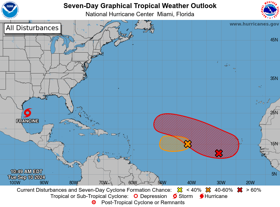
Otherwise, models are generally unenthused with any areas over the next week or so. It does appear conditions are slowly becoming more conducive for tropical activity late in September. It probably would be a time to watch the Caribbean for any threats. But we’re a long way off from that right now.
Our next update will again be this evening before 9 PM CT with the latest on Francine.
Matt, How does happen? NHC just changed GULF Shores AL from 10% to 50% chance of tropical storm wx. They haven’t said the word Alabama for 10 days. Thank you for all that you do!
We are finding that particular product difficult to use. The eastward shift probably means winds went from 30-35 mph to 40-45 mph. So not a big shift, but puts it in tropical storm force.
I have posted this before but it is a interesting, short read on PRE’s.
http://bgmresearch.eas.cornell.edu/research/ERFFW/abstracts/albany_moore_pre.pdf
Should satisfy the sciencey types!
Matt,
It seems anecdotally to me that if there is a change to a hurricane’s forecast path in the gulf in the days preceding landfall, it usually tends to go farther East and not West. At least this is true for Rita, Beryl and Francine. Are there statistics on this?
It’s an interesting thought experiment but it would be awfully hard to quantify. Some of that could be a function of storms wanting to naturally turn toward the Polar regions. Rotation of the Earth, the dynamics of storms internally, and the general “westerlies” we see in the higher latitudes will generally act to favor a storm going northward. In order to do that, it usually turns northwest, north, then northeast. So you could be seeing that happen a lot for that reason. It feels like it happens a lot because it probably does because of the natural order of things in the hemisphere. 🙂
This is quite possibly the most professional, best written, best presented hurricane blog it has been my privilege to run across. I have been posting links to this site to co-workers who follow weather as part of the job, as well as to family in the Gulf Coast region. Thank you for the updates.
Thank you for the extremely kind words!
Agreed to this blog being best source of info. Not from here. Have only experienced Ida. I am freaking out alone in NOLA . Now forecast is for direct hit?? How sure that storm won’t intensify beyond cat 2. Which is bad enough……i am definitely moving when my lease is up.
It’s coming in from the west (not east), so not a direct hit. There’s also land to cross between where it hits and NOLA. That’ll lessen the impact.
Thank you! Yes, this blog is the best but local news wind-up is hard to escape! I appreciate the info. Still moving back to MA, but a bit less nervous right now!
Matt, how risky would it be to go on a road trip from around Sept. 18 – 26? Is it too soon to predict what might be heading our way here in Houston? Thanks for your sage advice.
That Francine/jet stream extra is a messed up 2-for-1 deal.
I hope that doesn’t become the norm.
Reporting from Baytown near Cedar Bayou: Light shower rain bands started at 2:45pm. Little to no wind yet.