In brief: Three interesting systems dot the landscape from the central Atlantic to the central Pacific. The Atlantic wave continues to see slowly building development odds, but it’s terribly slow moving right now. In the Pacific, Lenora will bring rain chances to the Sonoran Desert, while Kiko is ultimately looking like a storm to watch for Hawaii.
Atlantic tropical wave
Well, the tropical wave in the Atlantic has still failed to classify as an invest as of this writing. Odds of development are up to 80 percent today. And if you look at satellite, it appears that the wave is rather compact, or at least the thunderstorms associated with it are.

Whatever happens here, my guess is that this is not going to be a large system (in size) initially. The other story with this wave is how slow it’s moving. We’ve seen some systems book it across the Atlantic in recent years, but this wave is the Sunday driver of disturbances, really taking its time to come west. We’ll continue to say that this area should be watched for the Caribbean islands, but the fact of the matter is that most model guidance doesn’t bring it near that area until the earliest next Tuesday, if not Wednesday.
From a development perspective, the slow movement of the wave can be both good or bad. It gives it more opportunity to perhaps be impacted by external things like dry air or shear. On the other hand, it also gives it a chance to perhaps insulate itself from those impacts for a time, particularly by being such a compact system. Smaller systems can also ramp up fairly quickly, but they can also very quickly weaken if impacted by hostile conditions.
So, we still have a lot of time to watch this, but it does seem like the islands, including Puerto Rico will want to continue to monitor the progress of this system as it crawls west. There are still a number of model solutions that turn this to the northwest and away from the islands, so it’s not a guarantee that it even gets there. But we do know that there is at least potential for development with it that could bring impacts to the islands next week.
Beyond the Caribbean, the overall weather pattern next week has been trending toward a slightly stronger trough along the East Coast of the U.S.
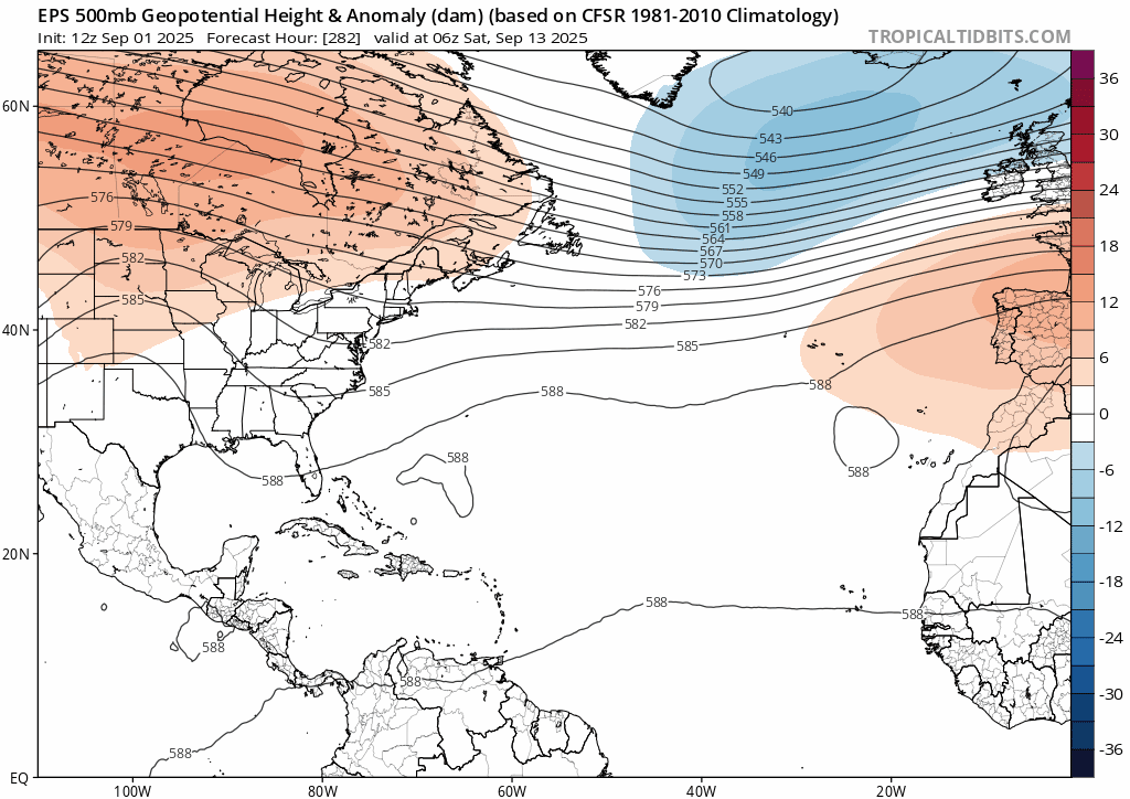
What does this mean for the future of a possible tropical system? Well, for one it would likely begin to gain latitude at some point near or in the northeast Caribbean. It could turn before that point, but this overall setup favors something eventually turning northwest. This is not until next weekend though, a good 8 to 9 days away. So, yes, keep an eye on this if you live from Florida to the Carolinas or in Bermuda, but we have a long, long way to go.
Beyond this, another tropical wave may emerge off Africa next week that’s worth watching for the week of the 15th, but that’s way out there in time.
Pacific Hurricane Lorena
We talked the other day about Lorena possibly becoming a tropical storm or borderline hurricane. Indeed, Lorena did just that, becoming a stronger category 1 storm. It is now undergoing weakening as it moves into cooler waters near Baja, and it will likely come ashore later tomorrow as a disintegrated, post-tropical depression.
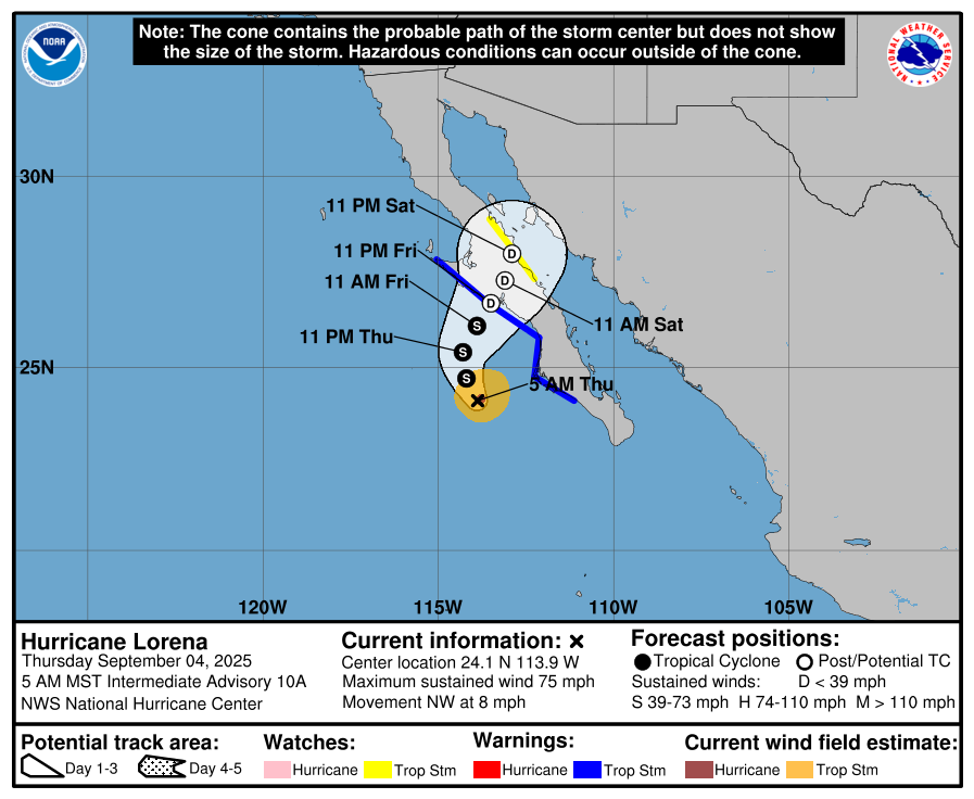
Where Lorena may leave its mark is via rainfall. Flood Watches are posted across the Sonoran Desert from southeast California through Phoenix into Tucson. Interestingly, a combination of factors, including the slow movement of Lorena, cloud cover overspreading the desert, and some reduced instability from storms overnight may act to limit how much in the way of thunderstorms can develop today across Arizona. There are always uncertainties, but it may be that the desert sees less activity today than perhaps initially thought.
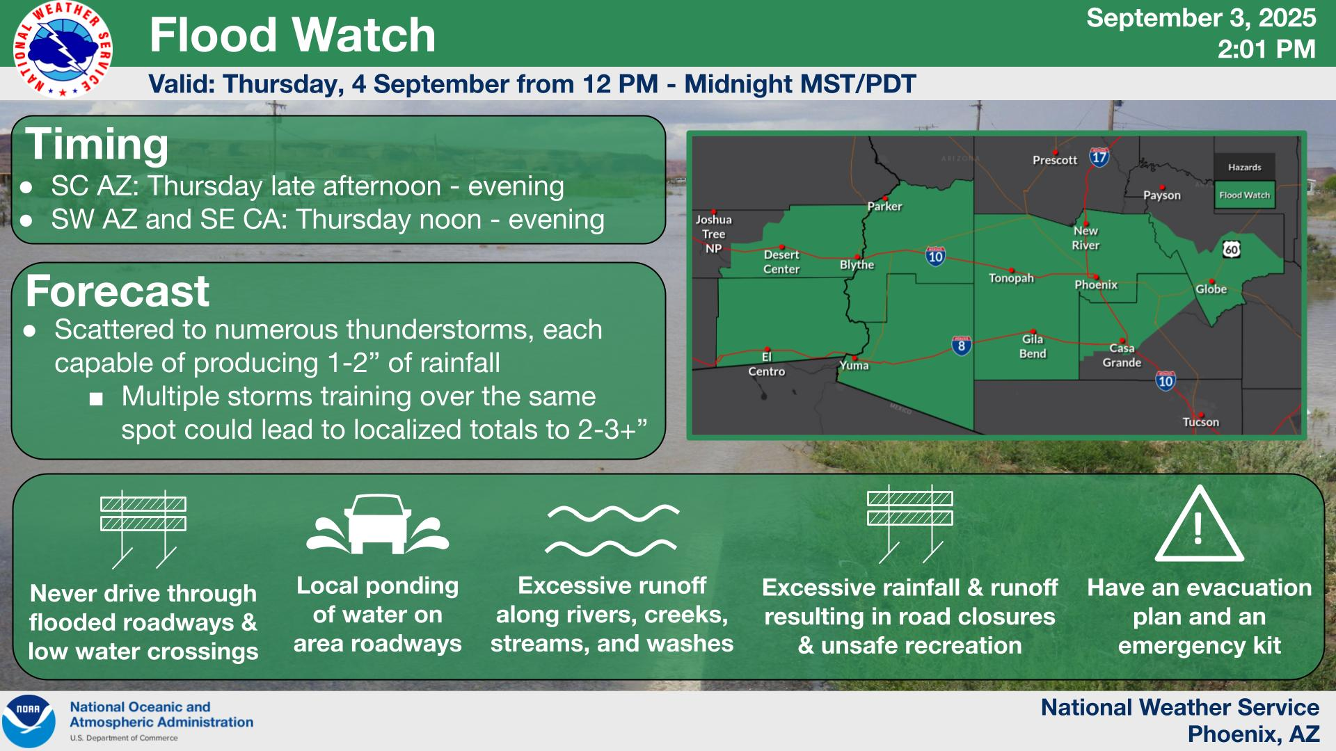
The higher storm risks may end up being north of the major cities of southern Arizona and north of I-10. While rain rates and totals should cause some reports of flash flooding today or tonight, only very isolated areas seem to be at risk for something more significant. A few higher end totals of 2 to 4 inches may occur in spots, but those would be the exceptions rather than the rule.
Some of the higher end rain risks pivot into New Mexico and Texas this weekend.
Pacific Hurricane Kiko
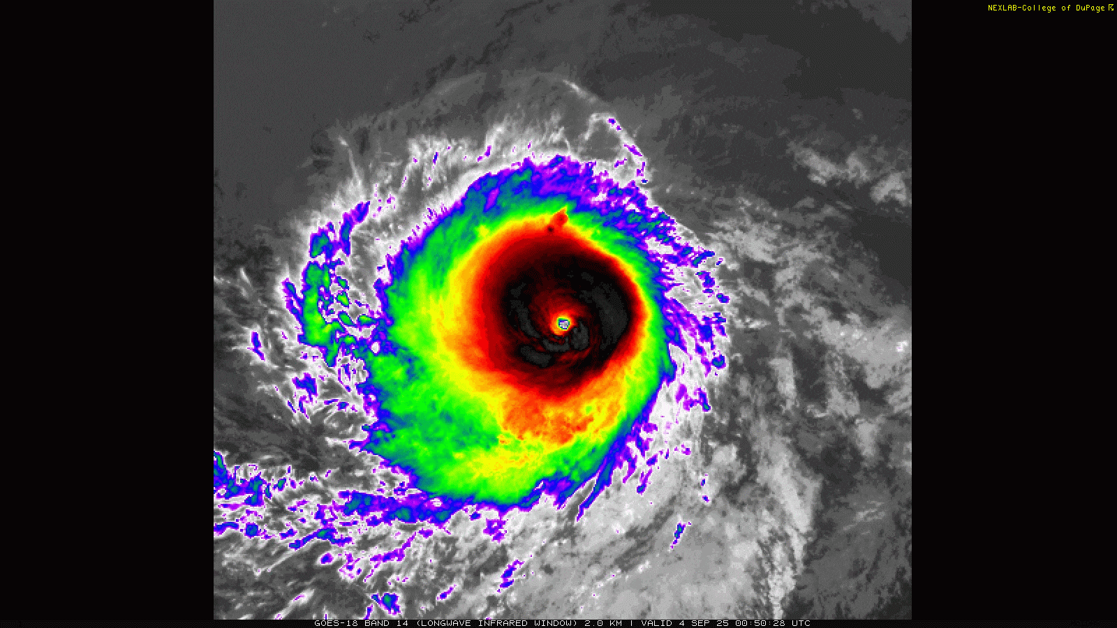
In the middle of the open Pacific, Kiko has blown up into a monster hurricane the last couple days, achieving category 4 intensity, with winds currently still at 145 mph. However, it seems as though Kiko is undergoing an eyewall replacement cycle, as it has lost a little of its luster from 12 hours ago. You can see on the satellite imagery taken 12 hours apart how Kiko’s structure, while still extremely healthy, has degraded a bit.
Kiko marches onto the west, not currently threatening land. However, Kiko will be an intriguing item to watch as it relates to Hawaii.
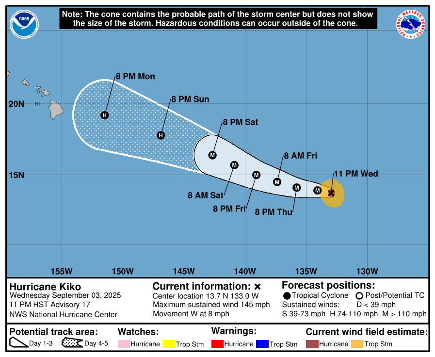
You can see above how by Monday, Kiko is a few hundred miles west of the Hawaiian Islands. Kiko will dramatically weaken from where it is now, but it seems as though it may potentially maintain some degree of intensity.
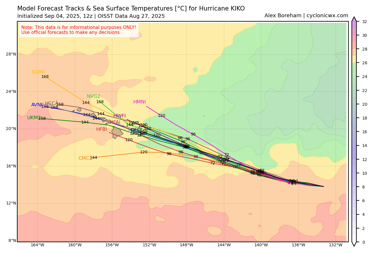
Notice how Kiko will likely traverse water temperatures below 26°C over the next few days. For hurricanes, generally we want to see above those levels for intensification. So we should slowly see Kiko weaken. Now, what is somewhat interesting is how water temperatures do increase again around Hawaii. We’re at least 5 to 6 days out from any possible impacts in Hawaii, but this is a storm worth watching for the islands, both from a wind and rain perspective. At the least, this may be a Douglas (2020) or Linda (2021) type impact risk for the islands. Beyond that, it’s a little too early to say. But folks in Hawaii should be monitoring the progress of Kiko for next week.