Headlines
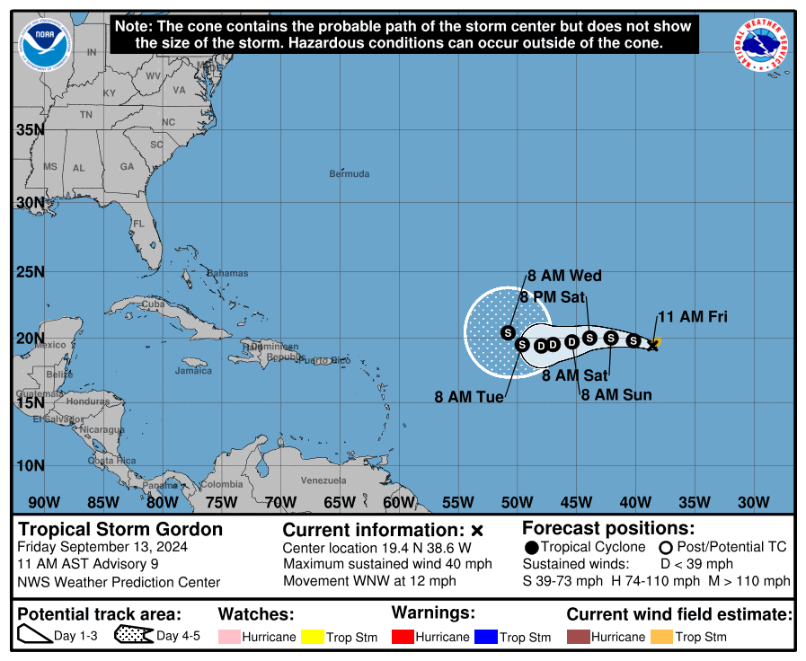
- Tropical Storm Gordon is of no threat to land.
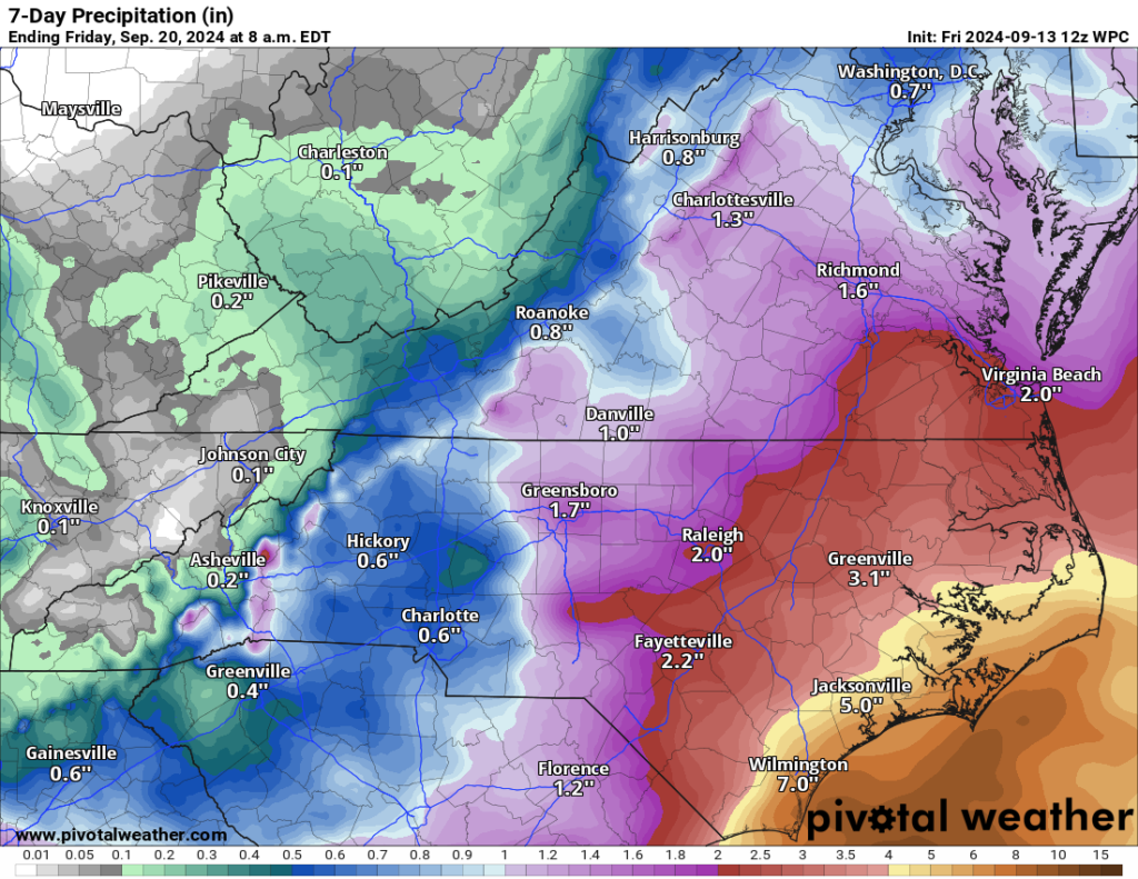
- A low pressure system in the Southeast is a tricky forecast but likely to cause heavy rain and flooding concerns next week in the Carolinas or Virginia, as well as marine impacts.
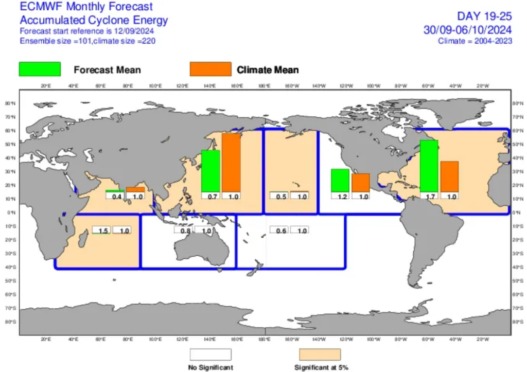
- Longer-range modeling suggests that we’ll be watching the Caribbean and Atlantic closer in about 2 weeks.
- Thank you to our Friday featured sponsor: The Heitmann Insurance Agency!
Of note for our Houston readers (or other interested parties), over at Space City Weather, Eric posted about the “western shift” in Francine’s forecast on Monday that, if anyone follows me on social media knows exasperated me. The reality is that hurricane forecasts are subject to change, and although the Beryl forecast was mediocre at best, especially a few days ahead of the storm, every storm is unique. No two storms follow the same exact rules, and if we see a reason to expand a region of concern, we will. I saw social media posts emphasizing a dramatic western shift, a specific concern of a threat of “more impacts to Houston,” among other poor takes across social media from weather enthusiasts and (importantly!) meteorologists alike. It’s exhausting, but we will continue to operate this site as we have since inception and as we operate Space City Weather, which is to say with honesty, transparency about the data and our thinking, and accountability when we get it wrong.
Tropical Storm Gordon & friends
Storm number seven of the Atlantic hurricane season has formed, with Tropical Storm Gordon out in the open Atlantic. It is of no threat to land.

Gordon looks decent on satellite imagery this morning, but it is so far north that it will eventually run into dry air and likely suffer the consequences. Of note, it appears the Gordon will be the first storm of the Atlantic hurricane season to miss land.
Meanwhile, the two invest areas approaching the Caribbean have become one invest area. Invest 92L is gone, but Invest 94L has maybe a very, very slight chance to briefly form this weekend before it likely has to deal with too much land.
Southeast low pressure to cause headaches
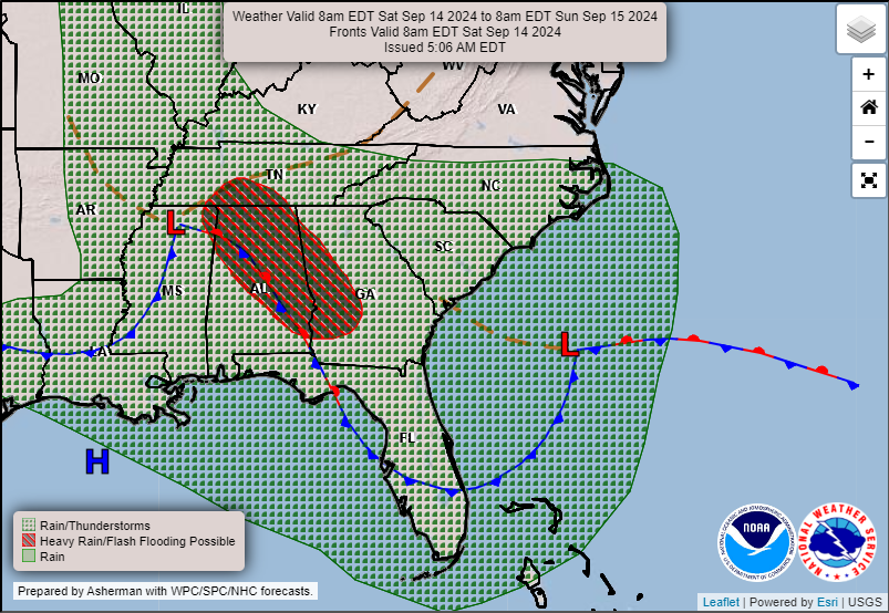
The Southeast coast will be an area to continue to watch heading into next week. Tomorrow and Sunday will see a cold front slide off the Southeast coast with an area of low pressure spinning up along its remnants.
This won’t be a “true” tropical system, but it may eventually try to develop into a subtropical-type storm or depression off the coast. In general, it would track generally slowly northward or northwestward. Although this probably won’t be a true tropical system, it will probably behave like a tropical storm or decent nor’easter off the Carolina coast. This means heavy rain and coastal impacts will be possible. So don’t focus on classification nuance here. Current rainfall forecasts show upwards of 4 to 8 inches over the next week on the coast of North Carolina.

Depending on exactly how this unfolds and tracks, there could be a pretty significant flooding threat in the Carolinas next week, in addition to rough seas, beach erosion, and tidal flooding risk. Rip currents will also be strong this weekend. Stay tuned for more on this. We’ll have an update on Sunday for you.
Notably, after praising the ECMWF AI (AIFS) model and ICON yesterday, those models are struggling with this area as well, so this is a low confidence situation.
Late September: It may get busier
Looking down the road, there is reason to believe that the Atlantic may be shaping up to get a bit busier. We can have some pretty wild Octobers. Just look to 2020 for evidence of that. After weeks of a background of sinking air over the Atlantic basin, the background is likely to shift to more rising air. This supports and sustains tropical development. It may help reduce some of the drier air that has plagued the basin as well. In general, it just looks healthier for more activity after next week.
One area that models are honing in on is the western Caribbean. We’re seeing signals on the ensembles and the European AIFS model for some sort of spin up possibly occurring there in about 12 to 14 days. It has been showing up for a couple days now, and this overall shift to a more hospitable pattern supports it happening. The ECMWF sub-seasonal/weeklies model from yesterday shows above normal tropical activity in week 3 today.
This is the first time I’ve seen this in a while, which seems to indicate that this idea of a possible Caribbean system or more Atlantic activity in general is actually supported in the models too, not just theoretically. So, it’s still a couple weeks out, but this gives you an idea of where we’ll be looking as we head toward later September.
Friday featured sponsor: The Heitmann Insurance Agency
Thank you to The Heitmann Insurance Agency and all our sponsors for their support of The Eyewall this season!

The Heitmann Insurance Agency has served Texas for 20 years in providing Home, Auto, Flood, and Commercial insurance. They have years of experience helping people insure their property from accidents and storms. They can provide you with dozens of options for your insurance needs and will give you free advice if you have questions and cannot reach your current agent.
Give them a call at 281-207-5075 or email them at “[email protected]” and they will gladly answer any questions or provide you with alternative quotes. www.HeitmannAgency.com


When is the next cold front that could possibly push things away?
Nothing set in stone, but perhaps later next week or the week of the 23rd.
Matt: This will be an interesting setup if there’s a cold front plus something stirring in the western Caribbean.
🍂 🎃 🍂
OK LMAO Matt please take another look at line 6 under “Of note for our Houston readers…” You guys really, really need the weekend off.
Yeah that was an oops! First time i’ve done that in 20 years Good catch, and yes, we’ll take tomorrow off! 🙂
You both do an excellent job and I greatly appreciate this site and the Space City site. Let the haters hate. Keep doing what ya’ll do!!
Regarding storms that form in the western Caribbean, do you have any data indicating what typically happens with these systems? Do they usually move west into Central America? Northwest into the Gulf of Mexico? Or north into Cuba and Florida? I seem to remember one storm that formed in the western Caribbean that seemingly defied prevailing science and moved east/northeast until eventually petering out.
I remember that storm you’re mentioning too…a very weird case. In September and October there is a whole spray of possibilities, but there seem to be 3 clusters…the majority of them go into Mexico or Central America, but there seem to be two other clusters of tracks toward the southern Florida Peninsula and the western Florida Panhandle. So, your mileage will vary. Only a handful have ever come to Texas or northern Mexico.
“dramatic western shit”. Truth in typo!
Typo.
But was it ?
Given the predictions for this season, any increased likelihood of Texas seeing storms into October or can we still hope to have a sign of relief as September ends? 🤞🏻
Lisa C: It’s not out of the question especially given the wacky year we’ve had. By this time of the year, however, the steering currents begin to change plus the cold fronts beginning to come down generally tend to steer tropical systems elsewhere. But again, it’s not 0% that we won’t get another one.
Matt & Eric, i think a lot about how difficult your work is and what a great job you guys do! Thanks so much. There’s something about a dangerous storm heading in your general direction that shakes folks to their core. Hope we’re not too difficult! Thanks again. Alyce