As of 3 PM ET, there are 16 “catastrophic” Flash Flood Emergencies in effect across the Appalachians. They range from Virginia to North Carolina to Tennessee and South Carolina and Georgia. The criteria for issuing flash flood emergencies is much more stringent than that of the typical flash flood warning. There needs to be an imminent risk of severe damage and/or loss of life. At least 16 counties or communities are reconciling that at present, not to mention the ones that have already been through things today. Rain is finally, mercifully winding down. But as noted this morning, the damage has been done.
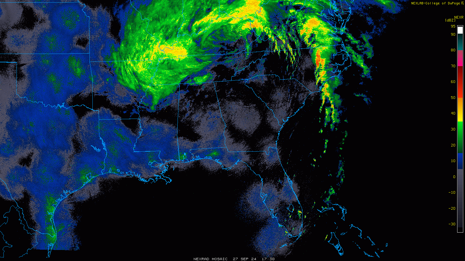
The next phase for Helene will be as a localized flood producer in the Ohio Valley, but hopefully not as prolific as we’ve seen in Appalachia.
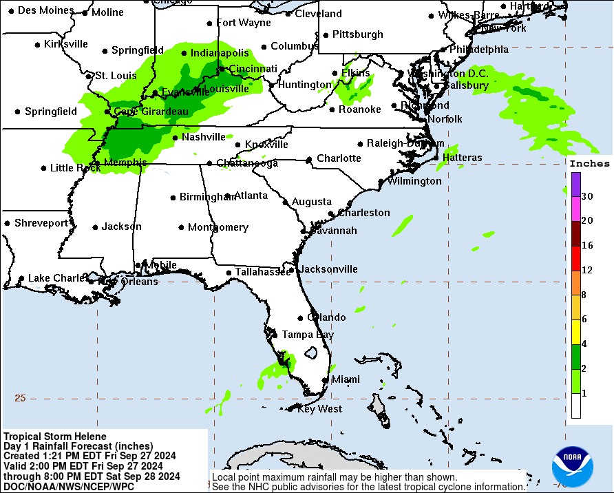
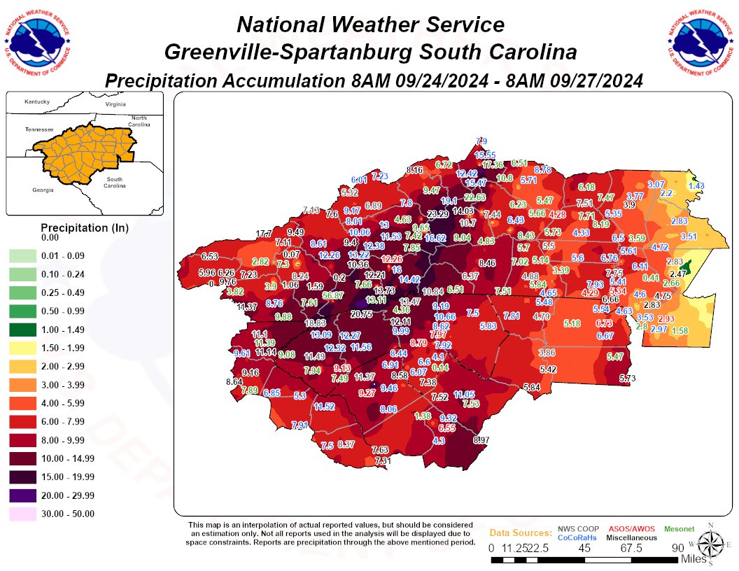
It’s been tough to keep tabs on reports and damage and incidents. I think the death toll has come in around 25 so far based on various reports. Power outages sit around 4 and a half million or so at this hour. Rain totals have been enormous across Georgia, South Carolina, and North Carolina, with over 20 inches in some spots.
Just one example of a river gauge gone crazy is in Asheville, NC for the Swannanoa River at Biltmore.
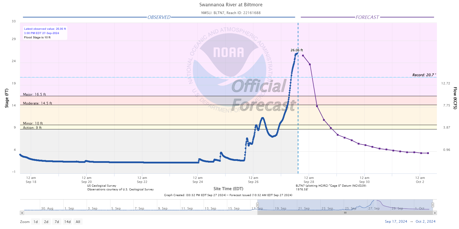
Forecast to exceed the flood of 1916, the gauge likely topped the presumed 26 foot level set back in spring 1791 according to Tennessee Valley Authority records. Whatever the case, this will be a devastating flooding event in Asheville and western North Carolina as a whole. According to the Georgia Climate Office, the 48 hour rain total of over 11 inches in Atlanta is the new record for a 2 day period, breaking a record by about 1.5 inches that has stood since 1886.
Anyway, the toll of Helene looks pretty horrible. The forecasts were incredibly precise and well done, but at a certain point, there is only so much you can do. We hope for the best for those impacted by Helene, particularly as a blog based in Houston which has seen plenty of flooding calamities.
Two other notes today before closing. First, Tropical Storm Joyce did indeed form from Invest 98L in the Atlantic. It is of no threat to land.
Second, the odds of development on the Caribbean area of interest next week remain at 30 percent. I continue to see two consistencies in the modeling with this one. First, most are capping this one’s intensity. You will occasionally get a rogue GFS model run that churns out a strong hurricane, but for the most part, models have a substantially lower ceiling with this than they did with Helene at this point in its life cycle. That signals that perhaps this one has a chance to not be a huge ordeal. Secondly, they cannot agree on track at all. There’s no theme of note here, with solutions running the gamut across the Gulf. I would contend that this is not one to lose sleep over right now. We’ll assess things through the weekend and come back refreshed Sunday or Monday with the latest.
Thank for the detail and the candid narrative for those of us who are concerned but not scientists.
Thank you for the non-hype forecasting.
Is there any geographical or scientific reasoning you can share why Louisiana has had 4 major hurricane hits and Florida 5 in last 8 years, while rest of entire guld Coast has 1 other (Harvey)
I’d contend both Florida and Louisiana offer more coastline to realistically strike given peak and late season “typical” steering currents.
Florida is really just hanging out there for a recurving storm.
quote: while rest of entire guld Coast has 1 other (Harvey) … (Gulf Coast)
You must have been away for a few years, especially considering the recent Beryl intrusion. 🙂
Bill and Patricia: 2015, Cindy: 2017, Imelda: 2019, Hanna, Laura, and Beta: 2020, Nicholas: 2021 , Harold: 2023, Beryl: July 2024.
I’m not Eric or Matt, but I was born and raised in Louisiana (coastal parish) and have been a tropical weather enthusiast my entire life.
Geography plays a part….perhaps the biggest part. Louisiana and Florida both have pretty long coastlines that jut out into the Gulf. By sheer geographical probability, they will both have higher landfall numbers.
Additionally, you’ll notice Texas is usually a target in the early season, while the Northern -> Eastern Gulf Coast is usually a target for later season storms, which are usually stronger. Of course, there are always exceptions, but they are generally rare.
The reason for this is because as the months go by and we get into September/October, the jet stream tends to dig down across the central U.S. and this tends to steer hurricanes northward/northeastward away from Texas.
Additionally, you start seeing frontal boundaries come through that do the same.
Traditionally, early season storms tend to be “homebrew” systems which form in the Bay of Campeche. Later season storms tend to form in the main development region and traverse the Caribbean and cross the western tip of Cuba and/or the Yucatan. By sheer rules of momentum (and, again, geography), poleward storms simply cannot physically go far enough west that a poleward turn would bring it up into the upper Tx coast.
Hope that makes sense.
I should add….yes, Texas has a very long Gulf coastline, as well, but its position in relation to general steering dynamics makes it difficult to be a target later in the season.
Would the Houston landfall be roughly 10/4 ?
Echoing the thanks for no hype. Hoping that it won’t form into a named storm, and that it doesn’t hit a densely populated area.
Is there a map of the actual storm surge (I know its early in the game)? The reason I am asking is the NWS? posted that the then coming storm surge was “un-survivable”. Of course the news folks jumped all over this and it became the never ending mantra until landfall.
It turns out it was quite survivable.
What a disservice! What’s going happen the next time they try and warn folks about impending dangers? We are not going to believe them…
How’s this for unsurvivable? https://www.tiktok.com/t/ZP8RxY6HR/
I used the word unsurvivable too. It was unsurvivable in many circumstances.
Go google the picture of the Bolivar Peninsula pre-Ike and post-Ike from 2008. Storm surge in action. Only reason a bunch of people didn’t die there is that they evacuated.
And as a poster here has also posted, go look at what the storm surge did to Horseshoe Bay, FL. If people had not evacuated there, there would have been a ton of fatalities.
I agree, the forecasting for Helene, and Francine was very very precise, and we had an idea where each was headed with time to prep..
I admire you guys, thank you for what you do!
Great job, Matt! I still can’t believe this isn’t your main gig!