In brief: The Atlantic remains calm, while the Pacific churns out its fifth storm, this one probably the strongest of the season so far, headed for hurricane intensity. Severe weather should also impact Kansas today.
Moment of meteorological Zen
Image of one of the most photogenic tornadoes you’ll ever see by one of my favorite storm chasers. This occurred on Monday evening near Wellfleet, Nebraska. It appears this occurred over open land, and I cannot find any reports of damage. Truly awestriking.
Today’s tornado risk shifts into Kansas.
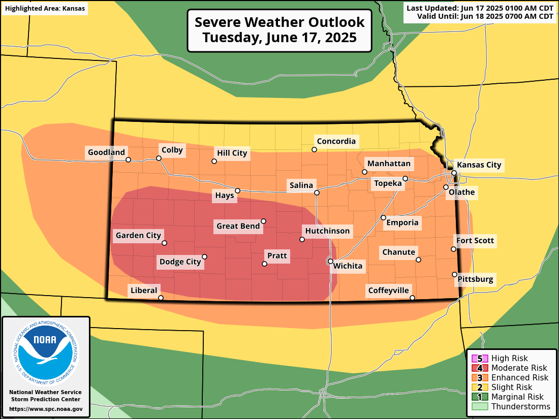
Tornadoes take the cake, but strong winds are the story today. Wichita has already seen a 101 mph gust this morning! Additional powerful storms are likely later today with 80 mph winds or stronger possible from eastern Colorado into Kansas. Be safe there.
Pacific Tropical Storm Erick
We’ve added the fifth storm of the Pacific season to the list as of this morning. Tropical Storm Erick has formed, and this one has some higher side potential as it moves toward the western coast of Mexico.
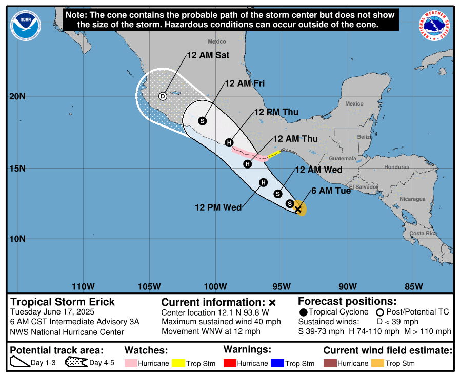
The forecast from the NHC and some modeling is actually quite aggressive with Erick. The official forecast brings this up to a cat 2 with 100 mph winds by the time it makes landfall late tomorrow night. However, some tropical models do indicate the potential for Erick to become a borderline major hurricane by the time it reaches land.
This is one of those storms that’s going to induce impacts on a wide swath of coast because of its forecast track and the geography of Mexico. The longer that this stays over water, the stronger it could get, and the wider the impacts on the coast of Oaxaca and Guerrero. The current track keeps it east of Acapulco. But it will be a somewhat close call. Eventually, even if stays offshore, proximity to land will probably induce weakening, but Erick should be a pretty significant storm for southern Mexico, particularly in Oaxaca.
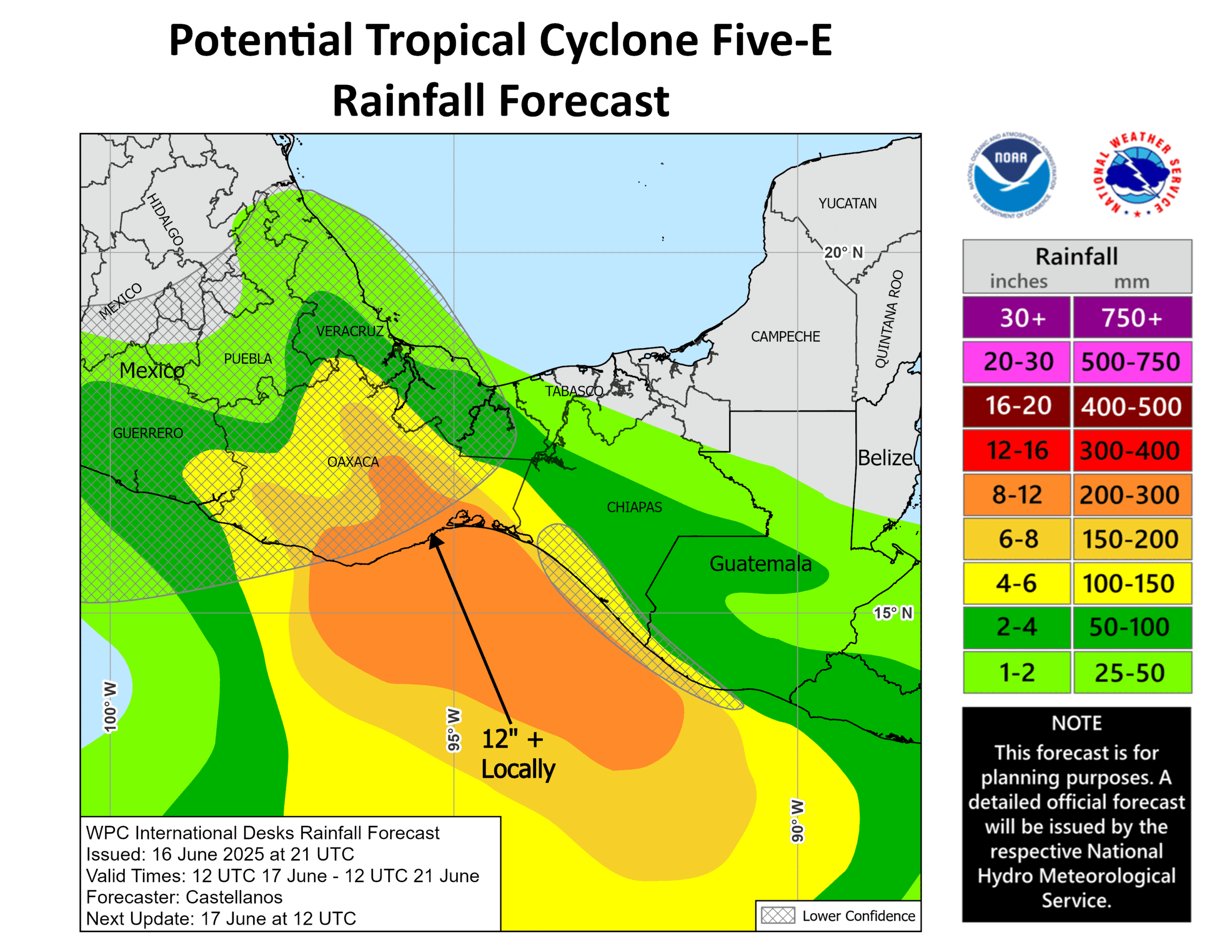
In addition, the heavy rains will continue up the east coast of Mexico through Veracruz and possibly Tamaulipas as a Bay of Campeche disturbance gets absorbed into the mess.
Otherwise, we are not expecting any tropical development in the Atlantic this week.
Matt, is it possible that Erick crosses over the narrow (124-mile wide) Isthmus of Tehuantepec into the Bay of Campeche? If it makes landfall there, that seems like a possibility.
Because of the angle it takes into Mexico, it should get ripped up by the mountains inland pretty fast. Any remnant would come due north through Mexico and not far enough east to get into the Bay. Even the farthest east models have that outcome right now.
The Gulf Coast has been really lucky that the MJO is further east and weaker than forecast.
Really, really lucky.
But for the Grace of Physics go I.
eastern Pac