In brief: Hurricane Erin is passing by the Outer Banks today, and it will begin to accelerate out to sea. Coastal flooding will remain an issue into tomorrow for the East Coast, particularly from North Carolina into New Jersey. Mostly wave impacts for Atlantic Canada, but also perhaps some wildfire concerns there too. The rest of the tropics are noisy, but only one wave bears much watching (Bermuda). Also, the latest on upcoming heavy rains in the Plains.
Hurricane Erin
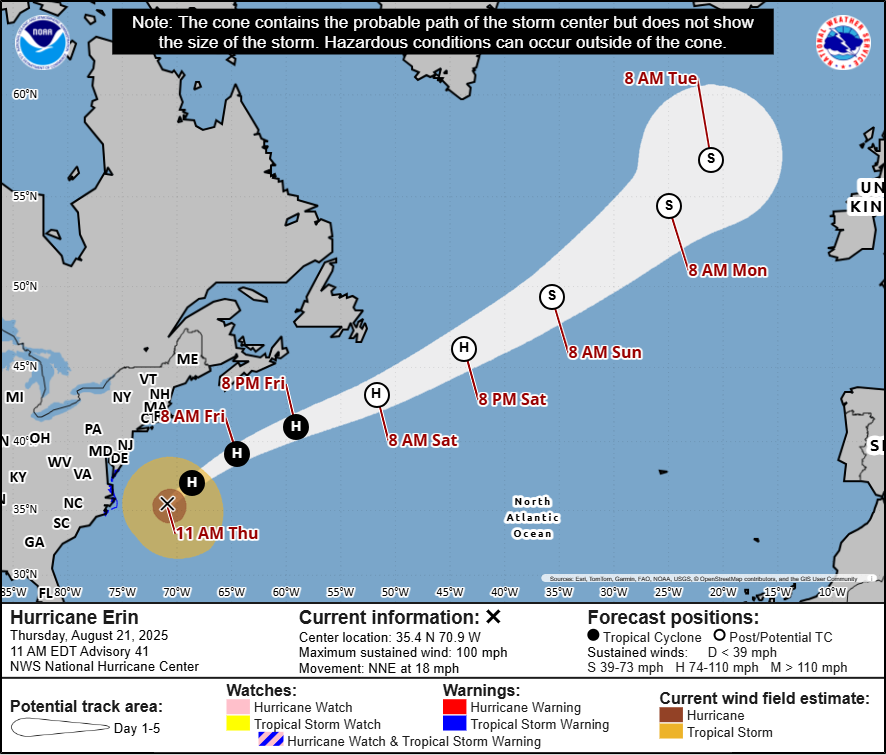
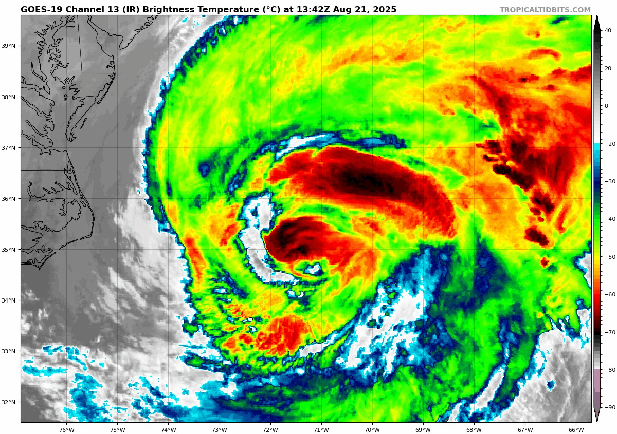
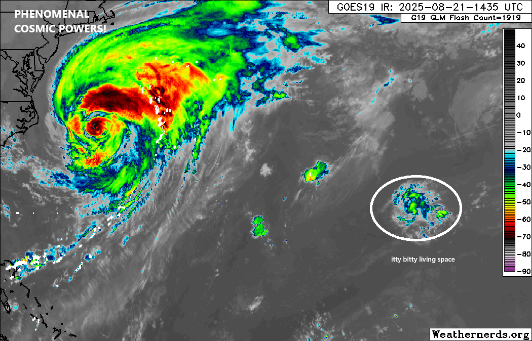
Erin is making its closest approach to the U.S. this morning. The very large storm sits about 210 miles east of Cape Hatteras, and it has begun to turn to the north northeast. The tropical storm-force wind field of Erin extends out over 300 miles from the center. Despite the fact that the storm has weakened to about 105 mph this morning, the hurricane-force winds extend out 105 miles from the center. This is a massive storm.
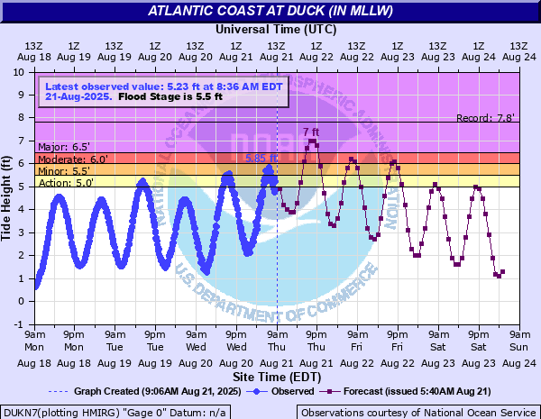
A 2 to 4 foot surge on the ocean side of the Outer Banks will be ongoing, coupled with powerful waves. It is expected that this evening’s high tide cycle will be the highest though, with Duck, NC seeing a water level up to about 7 feet, less than a foot below the 2003 Isabel record there and the highest since a nor’easter in 2022.
Flooding will be minor to moderate on the Pamlico Sound side of the Outer Banks, with downeast Carteret County seeing the worst this evening around 8:30 PM. High water levels are expected to continue into Friday, and it’s likely that some travel will become impossible through today and tonight in the Outer Banks, Ocracoke, and Carteret County.
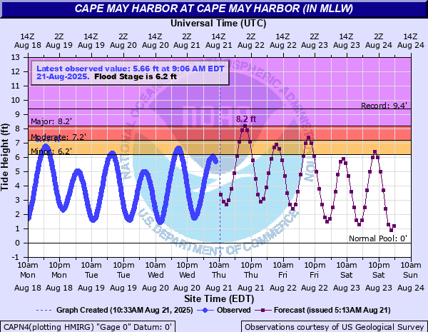
Even farther up the coast, the tidal flooding will be significant. Cape May, NJ is expecting a peak water level of 8.2 feet this evening, which will be the highest since the “Snowzilla” nor’easter of January 2016. Same goes for Lewes, Delaware.
Erin will continue to exit tomorrow, and conditions up and down the East Coast will slowly improve. For Atlantic Canada, the main impact will be rough surf, particularly in Newfoundland and perhaps Nova Scotia, where breaking wave heights could be 3 to 5 meters high. Erin should transition to an extratropical storm by Saturday.
Wildfire concerns?
A minor note, but perhaps a notable one, there will be somewhat enhanced wildfire risk in Atlantic Canada as Erin passes. Note the fire weather danger outlook for today is pretty high to extreme in parts of Newfoundland and even Nova Scotia and New Brunswick.
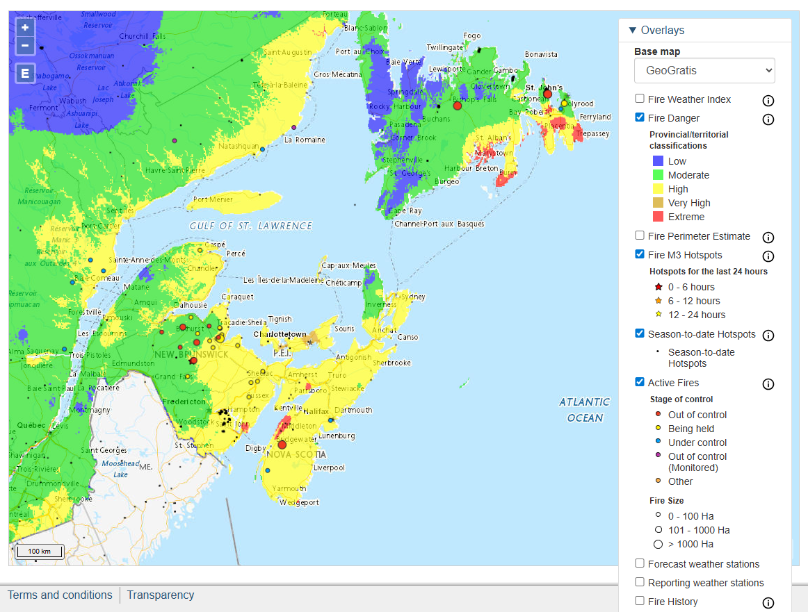
Portions of Atlantic Canada remain in severe to extreme drought conditions, so the combination of drier air being wrapped in from the north and gusty winds as the large swath of Erin passes by definitely can enhance fire danger. This is an element of storms that’s now on a lot of people’s minds in the wake of the tragedy in Maui a couple years ago, as a passing hurricane likely contributed some to drier, windier conditions there. Something for folks in Atlantic Canada to be mindful of over the next 2 to 3 days.
Rest of the tropics
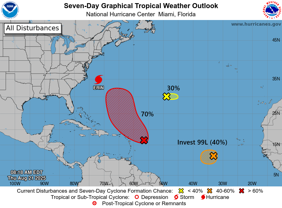
The Atlantic is a multi-colored menagerie of disturbances this morning. We have Invest 99L in the central Atlantic, the tropical disturbance approaching the Caribbean islands that we’ve been discussing for a few days now, and a little fella in the open Atlantic.
Let’s start from best odds of development to least odds.
The wave approaching the islands with a 70 percent chance of development is looking ragged but stormy today. There’s no sign that this is going to develop quickly, but it’s starting from a pretty decent baseline.

This one is expected to pass northeast of the islands, much like Erin did, so the only impacts will probably be some scattered thunderstorms this weekend. It’s hot in Puerto Rico and the Virgin Islands right now, and heat advisories are posted with hot, dry weather and Saharan dust causing hazy conditions. That will change as this passes. From there, it will probably turn straight north toward Bermuda. It seems as though it will turn out to sea before arriving in Bermuda, but interests on that island should continue to monitor this system in the coming days. As you can see below, most European ensemble members miss Bermuda to the east, but it is at least notable that some of the stronger outcomes get a little closer to Bermuda itself. Again, something to monitor at least.

We’ll keep tabs on this one.
To the east, Invest 99L continues to percolate west of the Cabo Verde Islands. This wave has looked excellent since emerging off Africa, but it has yet to do anything to get it over the hump yet to become a tropical depression.
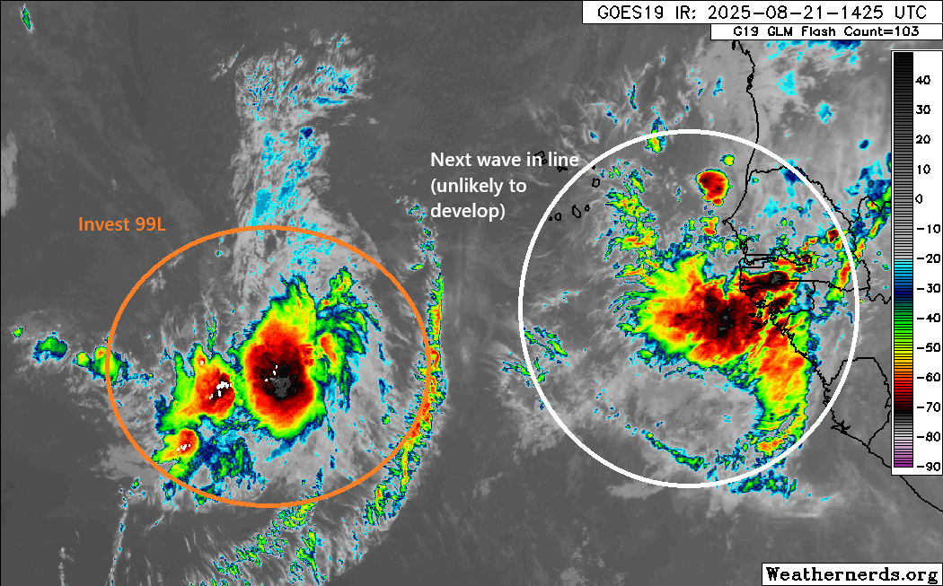
As 99L comes due west, it’s likely to run into a wall of wind shear. That should kill any chances of organization. The remnant disturbance should continue west toward the southern Caribbean. Typically, it’s a good idea to maintain some degree of vigilance with systems like this, as their ghosts can sometimes be resuscitated once in the western Caribbean. The bulk of what remains of this disturbance may actually end up close to South America, which would essentially wipe out odds of development, even in the western Caribbean. Still, it makes sense to keep tabs on this one in about a week or so, just to ensure it doesn’t pull a fast one on us.
The wave behind 99L is not expected to develop and should remain out at sea.
Meanwhile, the NHC tagged a little one this morning. That one near 30N/50W is kind of comedic looking this morning when viewed next to Erin.
That’s about it. As Eric noted yesterday, after these systems, we don’t exactly have anything noteworthy to home in on. Yesterday’s Euro weeklies suggest below average odds of tropical cyclone development in most of the basin for the week of Aug 24-Sept 1.
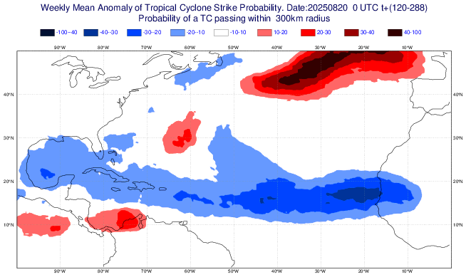
Notably, these odds turn neutral to perhaps even above normal by mid-September. So the first part of September may be calmer than usual, but we’re clearly not done with hurricane season yet. But this is good news in the nearer-term.
Heavy rain coming to the Plains?
After a somewhat calmer period of weather in the Southern Plains, we may see a return to more active, wetter weather heading toward next week. The WPC has already issued a slight risk (2/4) for excessive rainfall for next Monday.
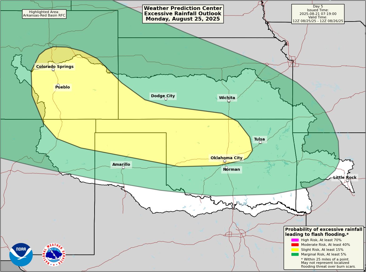
Rain totals are currently forecast to be on the order of 2 to 4 inches over the next 7 days, and there could be some locally higher amounts in parts of Kansas, Oklahoma, or Colorado.
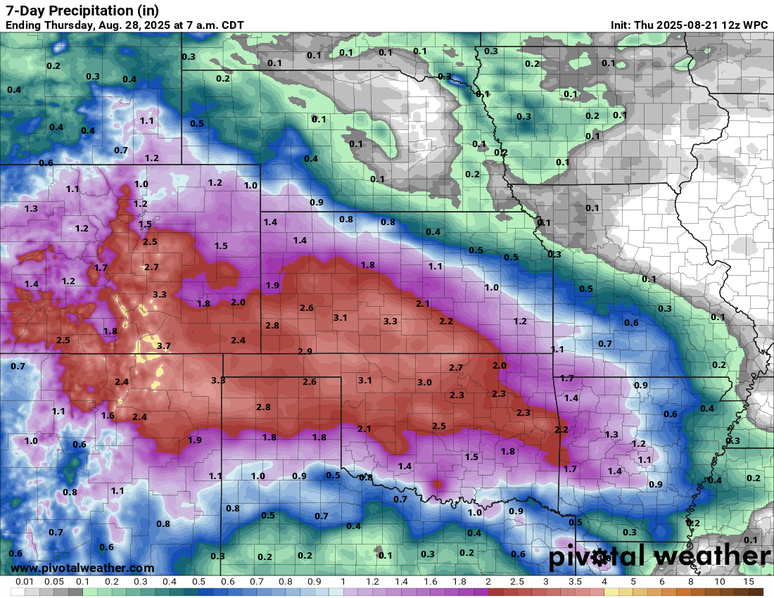
We’ll keep an eye on this as well.