Headlines
- Hurricane Ernesto prompts Hurricane Warnings for Bermuda as it tracks in that direction.
- Look for somewhat prolonged wind, surf, and rainfall impacts in Bermuda beginning tonight into Friday.
- Ernesto is large in size and will generate rough surf and dangerous rip currents far from the center along the U.S. East Coast heading into the weekend.
- Impacts are possible in Atlantic Canada Sunday or Monday, particularly in Newfoundland as Ernesto comes north and accelerates out to sea.
Ernesto struggling a little this morning
Hurricane Ernesto is moving along, north around 14 mph this morning over the Atlantic. A look at Ernesto on satellite tells the story pretty well.
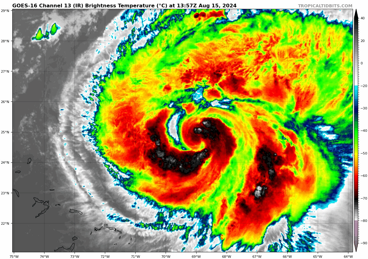
It’s pretty clearly fending off some dry air. It’s also a bit of a larger storm in size, with tropical storm force winds already extending out 175 miles from the center. The combination of Ernesto’s size and some of that dry air wrapping in is keeping a lid on much intensity gain today. The current maximum sustained winds are around 85 mph.
Ernesto’s track forecast
Ernesto is about 570 miles south southwest of Bermuda. Ernesto is going to take a weird track of sorts over the next 3 days or so, off to the north northeast, then northeast, then perhaps bending back north a bit. This is all due to steering currents that will be pushing Ernesto around. As I noted yesterday, the first trough will try to grab Ernesto and force it off to the northeast toward Bermuda. But as Ernesto approaches Bermuda, it will slow down and begin to turn back north somewhat as that trough exits. This will lead to a very close approach with a direct hit on the island. Regardless, hurricane conditions are likely to impact Bermuda by late tomorrow or Saturday, and a Hurricane Warning is in effect there.
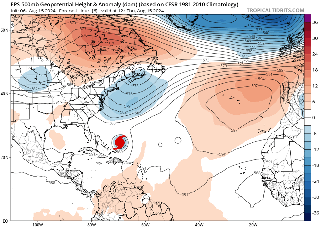
Beyond Bermuda, Ernesto will likely resume a slow northward movement in between two troughs. The next one moving in from the Great Lakes will try to also “grab” Ernesto, but it will also be following the steering currents around high pressure between Bermuda and the Azores. Thus, we should see Ernesto resume a slightly faster north northeast or northeast motion. Whether this happens fast enough to avoid a collision with Newfoundland remains to be seen. This will probably pass east of Nova Scotia and Prince Edward Island, however. Still, it’s likely that Atlantic Canada will see at least some impacts from Ernesto as it passes by, including gusty winds, rough seas, and perhaps some heavy rain.
Ernesto’s intensity and impacts
In terms of intensity, Ernesto should continue to slowly strengthen over the next day or two as it approaches Bermuda. Depending on how much it can whittle away the dry air, it may approach major hurricane intensity before passing close to or over Bermuda. It’s also worth noting that the slowing forward motion as it approaches Bermuda will likely prolong some of the wind, rain, and surge issues on the island. So even if this comes in a bit weaker than forecast, it may punch above its weight class given the slow movement and prolonged impacts. Bermuda is no stranger to hurricanes, but folks should take this one seriously.
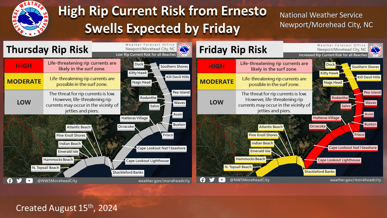
In addition, on the East Coast of the U.S. rip currents are going to become an issue heading into the weekend as Ernesto passes offshore, especially given the large wind field of Ernesto. Please follow all posted signs and flags at the beach this weekend. Rip currents are deadly, with nearly 30 deaths so far this year from them.
Ernesto should be out of the picture after next Monday or so, followed up by a period of calm Atlantic tropics. There may be some signs of life very late on model runs in the far eastern Atlantic, but we’ll see.
People need to learn how to read the water. We watched surfers for many years and none of the pros took their boards out until they spent a few minutes watching both the sets and the currents. It is pretty easy to see a rip current if you just take time to look. That also means getting in the water at night is far more dangerous because you can’t see your surroundings.
Exactly right. I grew up playing in the waves (Pacific Ocean). We watched the surf for a few minutes so that we could see where the channel was (easiest place to paddle out). You don’t just run out into the waves and attack them.
What effect do you expect this storm to have on Oak Island?
Assuming you mean in Nova Scotia. Nothing severe expected right now, with Ernesto likely to pass well to the east. Still, keep tabs in case anything changes.