In brief: Melissa is a remarkable storm in many aspects, from its slow motion to its intensity. But with severe direct human impacts expected in Jamaica by tomorrow morning, it’s tough to find any enthusiasm in the fascinating meteorological story unfolding with Melissa. We discuss the latest track and outlook for the storm.
Over the last 8 years or so, I feel like we’ve seen a number of weather events that make you pause and say, “Yeah, that really is awful.” Of course, bad storms have always happened. Extraordinary weather has always happened. There are countless weather events throughout history where you stop and say, “If that happened today it would be calamitous.” But it just seems like the frequency of these events, these mouth-agape events has just ramped up in recent years. Many of them are hurricanes, yes, but it does run the gamut from winter storms to extreme heat to floods to everything in between. Nature’s violence never ceases to amaze and terrify. And here we are again in the same situation.
Melissa became a category 5 storm this morning and then proceeded to join a club of elite storms, the 17 strongest on record, according to Dr. Kim Wood of the University of Arizona. The last storm to reach the 150 kt. maximum sustained wind threshold was Milton last year. Other notable names to do this include Maria, Mitch, Gilbert, Andrew, Katrina, Rita, Wilma, and Camille. It’s a literal unanimous first ballot hall of fame of storms.
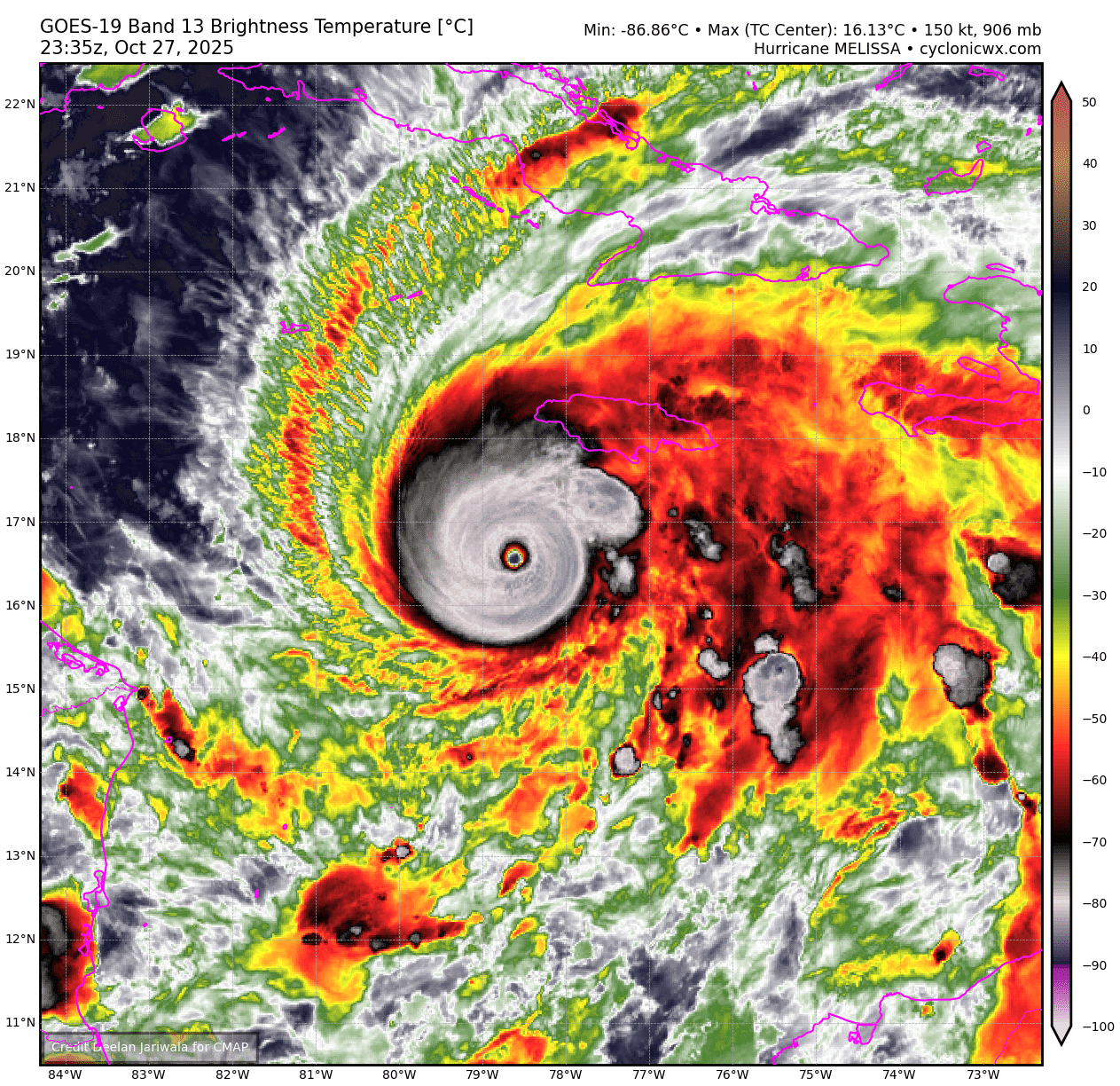
Maximum sustained winds remain at 175 mph this evening. There’s been some question if they’ve actually been stronger at times today, but it doesn’t really matter ultimately. It’s a question of semantics. The end result is all but written at this point with respect to Jamaica: It’s going to be a horribly bad storm for many places there. Many folks will be agonizing over each wobble on satellite this evening, but with a storm this powerful, it will find its way north and eventually into Jamaica, probably on the western half of the island. And besides that, the 15 to 30 inches of rain that most of the island will receive is bad enough alone.
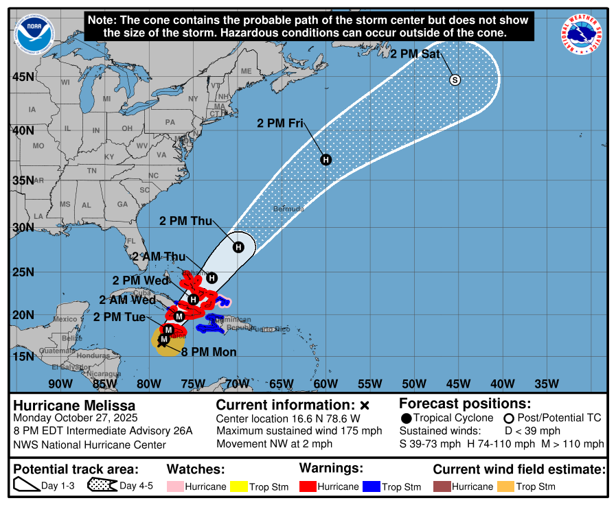
The question now is just how bad it will be on Jamaica. It’s also a question of how bad it will be in eastern Cuba. Melissa will definitely have lower intensity after crossing Jamaica. In the unlikely event that it somehow skirts and misses the island to the west, it could very well be an extremely powerful storm in Cuba. Interests there should be preparing for a bad storm regardless, easily the worst since Sandy in that part of Cuba. But there is a line between awfully bad and awful, and that’s what is riding on Melissa’s track tonight for Cuba.
The storm should be a lesser hurricane once it emerges off Cuba into the Bahamas, however several intensity models continue to show perhaps a small bump once in or just clear of the Bahamas. Basically, expect a significant storm in the southeast Bahamas, with perhaps a bump in intensity once past there. For Bermuda, it will be a close call with most models placing Melissa near or just west of Bermuda as it passes. Either way, the impact of a hurricane seems increasingly likely as Melissa’s wind field inevitably expands as it lifts northeast. More to come on those aspects of the storm.
Whatever the case, Melissa will enter a fragile period tonight where the atmosphere suggests additional intensification is possible, while the storm is pushing the limits of how long a hurricane can go without an eyewall replacement cycle disrupting it somewhat. While the outcome for Jamaica seems unlikely to change, the meteorological element and history books may change a bit depending on what Melissa gets up to tonight. All we can do now is watch and hope for the best.