In brief: Hurricane Melissa is en route to Bermuda tonight with hurricane conditions expected before it begins to turn extratropical while passing just southeast of Newfoundland on Saturday morning. We have updates below on the damage in Jamaica and how you can help storm victims. Also, join me today at 1P ET/12P CT for a Substack Live with Dr. Kristen Panthagani.
Substack Live today
Before we get into things today, I wanted to share that I’m going to be joining my first Substack live today! Today at 1 PM ET/12 PM CT, I’m excited to talk about weather, climate, and health with Dr. Kristen Panthagani, the author of “You Can Know Things,” as well as a frequent contributor to Your Local Epidemiologist. Both of those are must-read blogs in my opinion. Kristen is passionate about science communication like me, and we both believe that there needs to be a lot of interdisciplinary cross-collaboration in the sciences to learn from one another.
Link to our Substack live is here.
With Hurricane Melissa dominating the news, I am sure we will have no shortage of things to discuss.
Latest on Melissa
Speaking of, Melissa is en route to Bermuda this morning.
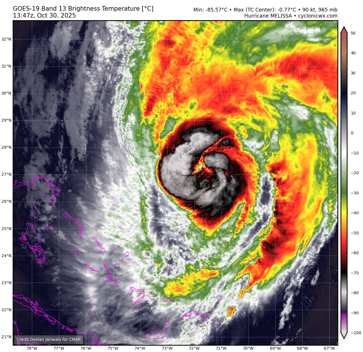
Melissa’s durability despite land interactions and moving into 30 to 60 kts. of wind shear is kind of impressive. This should eventually succumb to the shear to some extent. In the meantime, Melissa will likely hold serve today, potentially gaining a smidge more intensity before the shear just becomes overwhelming, cooler waters await, and the storm turns extratropical.
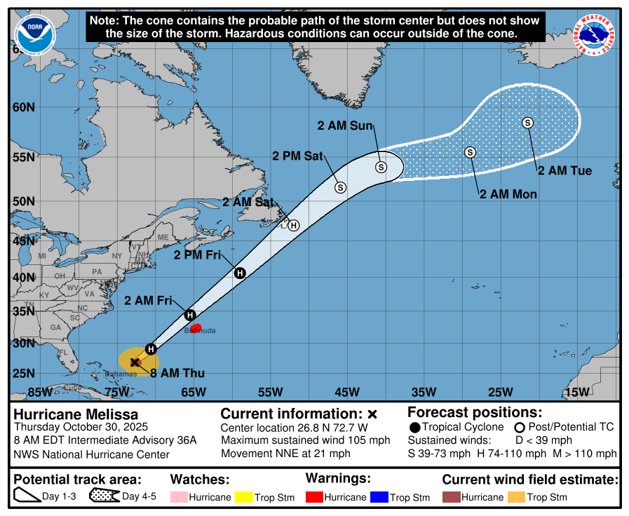
As Melissa passes Bermuda tonight, hurricane conditions are likely. With the storm picking up speed, don’t expect the hurricane impacts to last too terribly long there though. Thankfully, a direct hit on Bermuda is unlikely. Melissa will continue northeast, passing the Avalon Peninsula in Newfoundland on Saturday morning as an extratropical hurricane-strength storm. On the current track, forecast impacts would be mostly minor to moderate in southeast Newfoundland and the Avalon Peninsula, with the worst of the storm remaining offshore. If for some reason the storm tracks closer to Atlantic Canada, impacts would worsen in Newfoundland. As of now, this looks like a manageable storm, albeit one with the usual hazards from gusty winds to heavy rain to rough seas and high tides in Newfoundland.
Meanwhile, in Jamaica, we’re starting to get a fuller picture of the damage. These aerial views below are from St. Elizabeth, which is very near where Melissa came ashore. The damage looks equivalent to a massive tornado.
Oddly, some of the structures actually held up remarkably well too. So there is something to be said about how Jamaica handles hurricanes, considering this was as close to the worst possible storm you could have anywhere. That said, this damage is pretty terrible, and the recovery from Melissa is going to be lengthy and difficult. Black River seems to have been hit especially hard. The death toll is around 32 in the Caribbean overall right now. I’m sure that number will rise, sadly. Remember, in the immediate aftermath of a storm like this, you are only seeing a fraction of what actually occurred.
How to help the Caribbean
Here are a number of ways you can directly help out relief efforts, pulled in part from an Associated Press article on the topic.
United Way of Jamaica will donate directly to Jamaicans in the affected areas.
The American Friends of Jamaica is a fund that has been active for decades helping Jamaica.
Give Directly will provide cash relief directly to those impacted by the storm.
I also want to shout out the Center for Disaster Philanthropy which is focused on medium and long-term recovery. When the media and volunteers all leave, there will still be enormous amounts of work to do to recover from a storm of this magnitude. CDP works to help fill that gap.
Newsy Bits
I want to end today on a more positive note. Here are a couple more interesting news stories I’ve bookmarked lately about animals and storms. Hurricanes are tremendously devastating events, but sometimes they can highlight the remarkable abilities and resiliency of nature.
Florida Flamingos: After Hurricane Idalia in 2023, it was discovered that a flock of about 300 to 400 flamingos likely migrating between the Yucatan and Cuba had been blown off course and ended up in Florida. Some decided to stay permanently. The result? Hope that flamingos are going to become more established in Florida again thanks to some luck and a lot of conservation efforts. This also is a great example of how birds can get trapped in the eye of a strong hurricane and be displaced hundreds or thousands of miles. It happens often. (The Conversation)
Fly like the wind: A young whimbrel that had a tracking device was clocked in at a flight speed of 80 mph for 24 hours as it flew from Cape Cod to Venezuela. The reason? It navigated a tailwind around Hurricanes Humberto and Imelda and got a serious boost. Interestingly, a whimbrel last summer got trapped inside the vortex of Hurricane Milton, unable to fly out of it and likely died of exhaustion. It’s a perilous journey south in migration season. (Weather Underground)