Headlines
- Hurricane season is unofficially over, as no activity is seen over the next 10 days, taking us through to about December.
- 2024 will end up as a “hyperactive” season but barely.
- Meanwhile, the West is seeing a storm almost as strong as a major hurricane spinning offshore.
- Significant, damaging wind is possible in the Seattle area tonight.
- A prolonged atmospheric river in California and southern Oregon will produce over 10 inches of rain in spots, and a rare day 3 high risk (level 4/4) of flooding exists in northern California for Thursday.
2024 Atlantic hurricane season ends — we think
With the degeneration of Sara’s remnants yesterday, it would appear that we’re basically done with the 2024 Atlantic hurricane season.
Unfortunately, Tropical Storm Sara was deadly in Honduras while dumping upwards of 20″ or more of rainfall. As much as 1,000 mm (40 inches) was analyzed in northern, coastal Honduras. Though deadly, it appears that the number of fatalities will remain well under some other notable rainstorms of the past in Central America. Good warnings likely helped.
With that, the season seems to be over now, as we see nothing over the next 7 days, and the models are pretty quiet beyond that. So where will we finish? It appears 2024’s accumulated cyclone energy (ACE) will finish at the bottom of the list of hyperactive seasons. We had 18 storms, 11 hurricanes, and 5 major hurricanes. The 11 hurricanes tie for fifth most in a season.
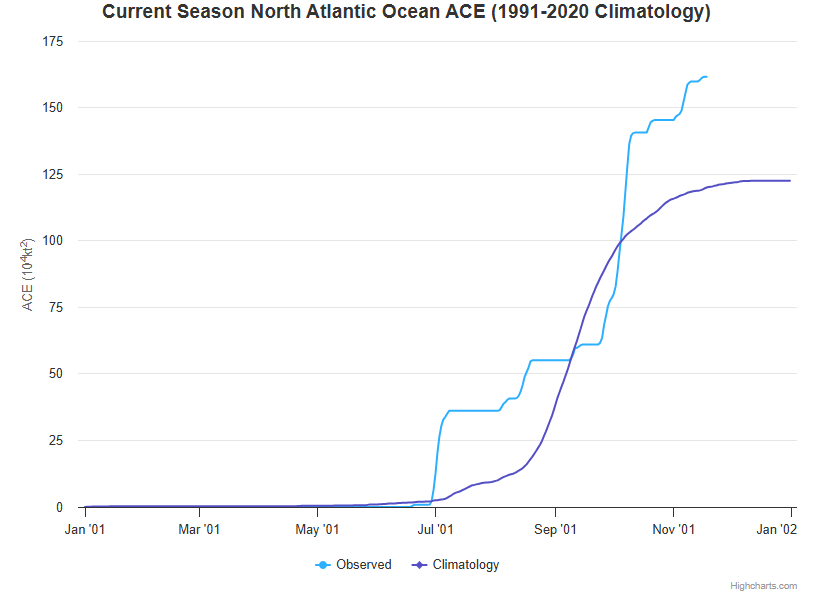
Did the season live up to the preseason hype? Probably not. But with over $190 billion in unofficial damages, it ranks near the top of the list of worst seasons on record. So you can find a metric that says this year was as bad as feared or was a total bust. The world is your oyster. But for parts of the Caribbean, Florida, and Appalachia, this season will be for the history books. And that’s really all that matters.
We can take a more in depth look at the season later. I want to transition us into post-season mode now at The Eyewall. We’re still experimenting with what works because we want to continue to grow our audience, but we also want to stay in our lane to an extent. Ultimately though, weather is our lane. And we should be chiming in when significant weather is a big story. And today, it’s a big story on the West Coast.
Western U.S. and Canada drenched and pummeled
There are two major stories developing on the West Coast. The first is occurring as I type this. A massive storm is rapidly deepening off the Northwest coast.
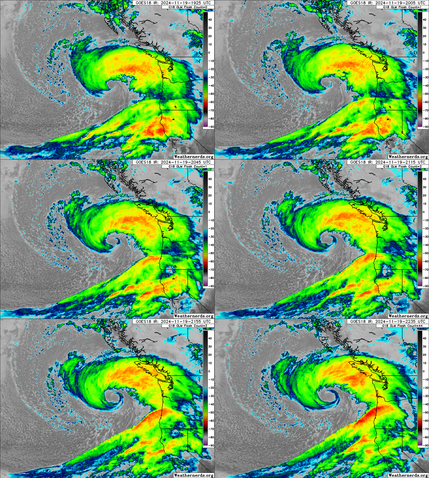
Yes, this is a bomb cyclone. That term gets tossed around often, and some people consider it hype. But it’s a legitimate meteorological term with a very specific definition. The lowest pressure of the storm must drop at least 24 millibars in 24 hours or less to attain “bomb cyclone” classification. While it may seem like bomb cyclones are rare, they really aren’t, happening multiple times a year on average near North America. What makes this particular storm stand out is the amplitude and rate of deepening that it is undergoing. Basically, the storm has dropped over 25 millibars just this afternoon, achieving “bomb” status incredibly quickly.
There will be multiple impacts associated with this storm, including a major downslope wind event east of Seattle tonight, where gusts in excess of 50 to 60 mph could occur in some of the heavily populated suburbs near the Cascade foothills. This will be worse than a typical wind event for this region, likely causing some localized damage and numerous power outages.
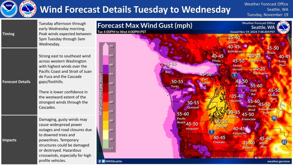
In addition, strong winds will occur at the coast, though thankfully the worst winds will remain well offshore due to the storm not making landfall. Heavy mountain snow and lower elevation rain will occur as well, and blizzard warnings are posted for the Cascades.
Meanwhile, a long duration atmospheric river event is going to take aim at California and southern Oregon in the coming several days, dumping copious amounts of rain and mountain snow, and some rain-on-snow potentially as well.
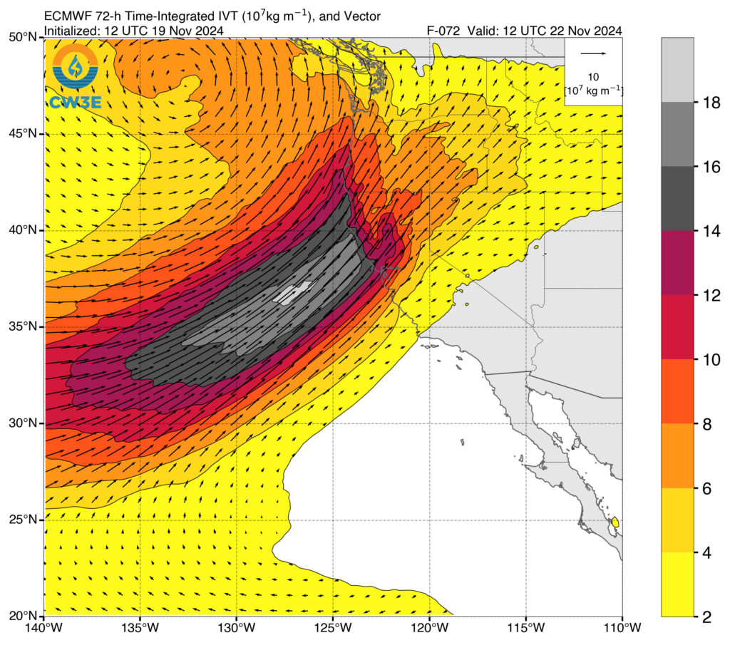
This will peak as a category 5 atmospheric river, which means significant impacts are likely, and the NWS Weather Prediction Center already issued a high risk of flooding (level 4/4) for northern California on Thursday, which I believe is the first time this has occurred for a non-tropical storm.
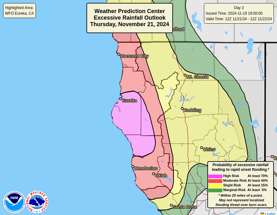
High risks don’t seem to be as rare as they used to be, but obviously for a day 3, confidence has to be exceptionally high or the risk has to be exceptionally high. I think a confluence of factors is impacting that. In terms of rainfall over the next week, it’s going to get messy. Over 10 inches of rain should fall in some of the mountains in northern California. Snow will also occur, but as the atmosphere warms a bit, the snow levels will increase. So this could be a damaging event in addition to a possibly beneficial one. Extremes rule the day in California. More to come.

Y’allhave a more thorough analysis of the PNW weather event than many of our local forecasters who rarely appreciate or recognize the effects of varied terrains have. Elevation, elevation, elevation.
You’re in your lane, Matt. Trust your instincts. You’re helping people. Keep going.
🌬🍂💜🍂
Boy, that is one ominous looking storm…
It’s just getting started and with multiple excessive effects (wind, rain, snow), I am glad I’m not anywhere near that area.