In brief: Invest 93L is almost out of time as it transitions into exclusively a flooding concern for parts of Louisiana. The tropics may pick up some activity toward later July. And there are growing signs that the end of July may end on a very hot note over much of the country.
Invest 93L
In terms of development, Invest 93L is approaching the end of the road. It seems unlikely that it will get a name, and it probably won’t become a depression either. There’s a lot of rain moving into far southern Louisiana this morning.
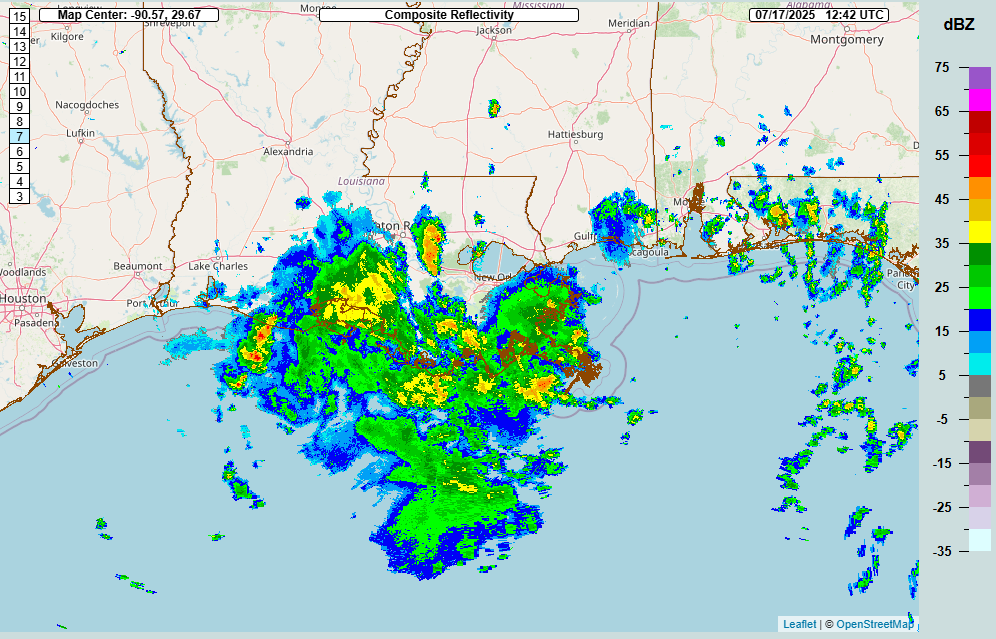
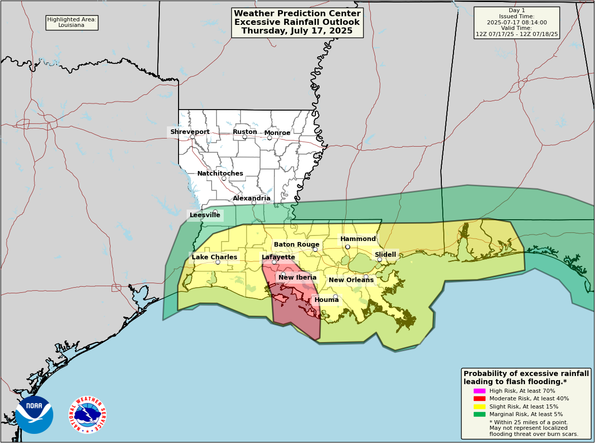
Given the current storm situation there, it would appear that several rounds of locally heavy rain are likely to push in through today and into tomorrow. The entire southern half of Louisiana is under a flash flood watch today, stretching from Lake Charles to New Orleans. The moderate risk for flash flooding (level 3/4) has moved into today and is focused primarily on the Atchafalaya.
While the expected rainfall totals today won’t be overwhelming (probably on the order of 2 to 4 inches or some higher amounts), the rate of rain may be enough to cause some locally significant flash flooding. Should 93L slow down a good bit further as well, that would serve to enhance localized rainfall risks. More rain and thunderstorms are likely tomorrow as well.
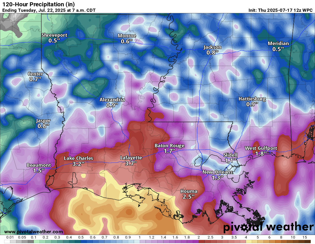
All told about 2 to 5 inches on average should be expected the next couple days. I would not be the least bit shocked if one or two spots did pick up as much as 6 to 9 inches of rain, but those would the exception rather than the rule I think. Overall, the flooding risks look a little less ominous than they did earlier this week, but they should not be discounted.
Rest of the Atlantic
While most of Atlantic hurricane season thus far has been quiet, there may be some changes brewing heading into late July and early August. I want to note this because I also think some of these changes may be somewhat overhyped in some circles. It’s not as if the Atlantic pattern will suddenly turn very favorable. It will, however, turn less hostile.
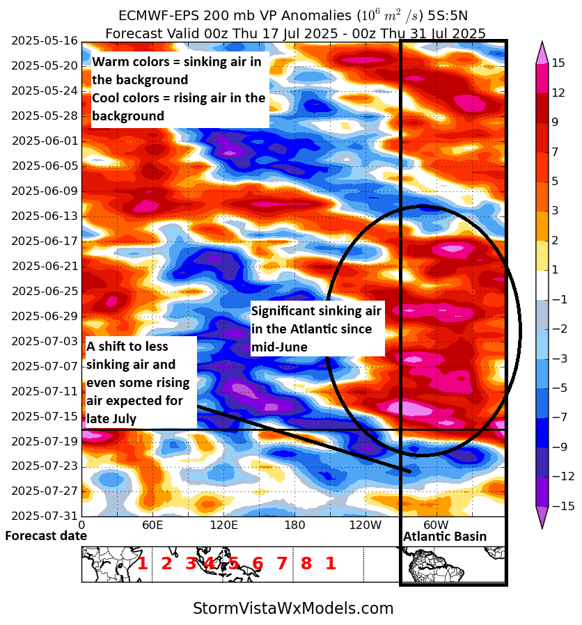
From the plot above, you can see that the background state of the atmosphere is expected to work into more favorable territory by the time we get to next week across the Atlantic basin. However, it’s still sort of lacking a lot of teeth. I’m just not convinced of this being the catalyst to bring us big activity yet. However, this is the first assault on the wall of unfavorability that has gripped the basin since early to mid-June.
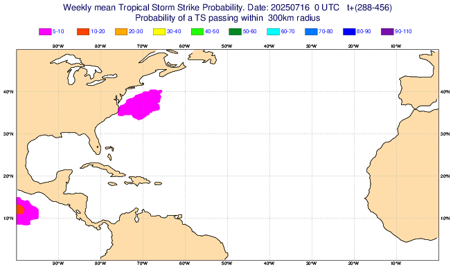
The European weekly model is not having any of it, though, going with very low probabilities off the East Coast to close July.
Right now, I see a pathway to a more active Atlantic, but I don’t see concrete evidence that it’s definitely coming. So for now we’ll just keep monitoring things.
Heat wave on the way?
When it comes to forecasting different weather variables, some end up better to forecast than others at longer lead times. Hurricane tracks at 10 to 15 days out? Probably poor! Total precipitation 10 to 15 days out? Probably a bad forecast. Will it be wetter or drier than normal? That’s a slightly higher confidence forecast depending on each weather pattern. How about heat waves? Well, let’s discuss that today.
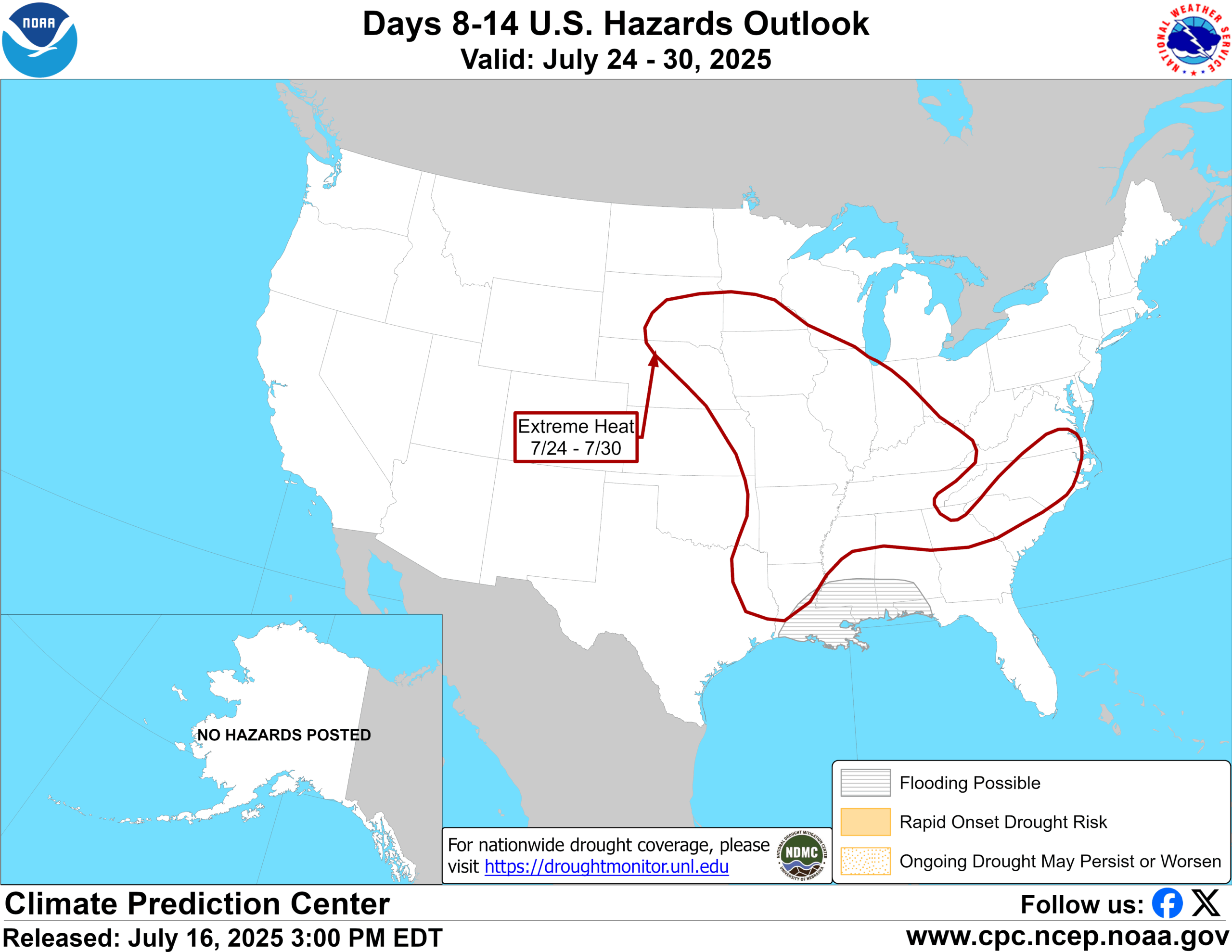
There have been some signals in the models over the last couple days for an expanding ridge of high pressure across the middle of the country in the 10 to 15 day forecast period. Yesterday afternoon, NOAA’s Climate Prediction Center added the risk of “extreme heat” to their forecast for July 24th through the 30th across a broad expanse of the country from the central Plains into the Southeast.
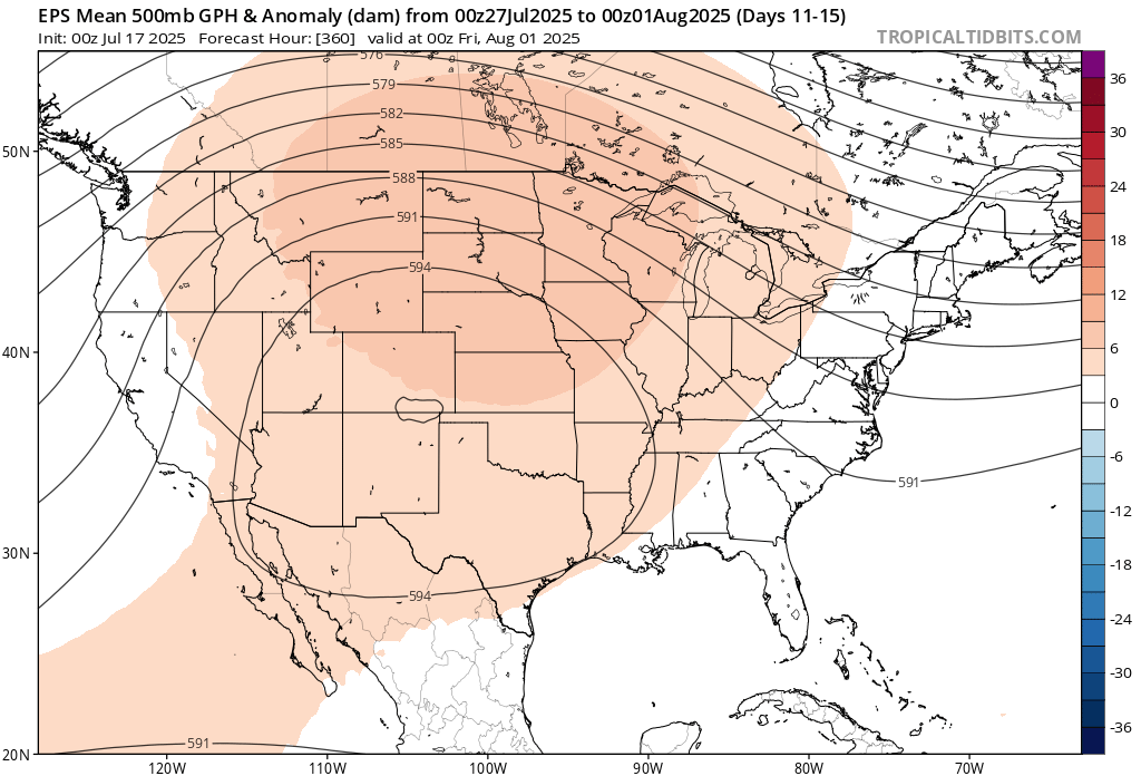
When we look at the broad weather pattern that is forecast from the European ensemble mean, an average of 51 ensemble members to produce a forecast for the 11 to 15 day period, you can see that there is a very strong signal for above average heights in the upper atmosphere, a signal for hot weather.
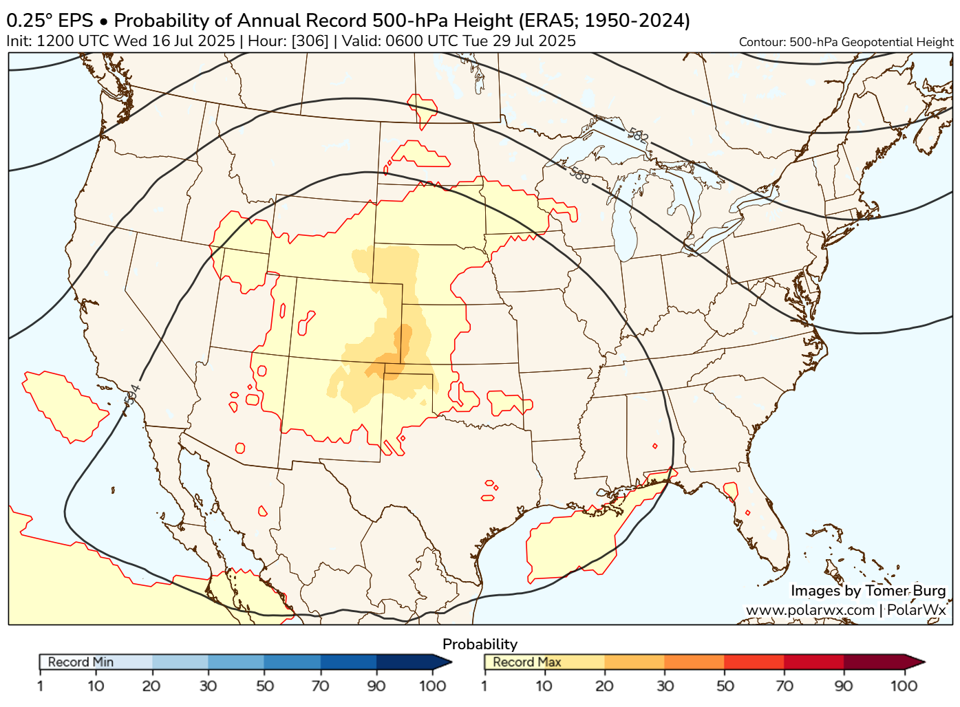
In fact, if you look at the potential for annual record 500 mb heights, or how many of the ensemble members are predicting that the intensity of the ridge will break all-time records, somewhere in the range of 20 to 30 percent of the European ensemble members are calling for just that. That’s a very impressive signal at this lead time.
Now, the Euro has been wrong before at this lead time. In fact, even a couple times this year it’s overestimated the heat somewhat. However, this is a slightly different scale and setup, and it has additional support from the 51 member European AI model ensemble as well. Record or not, it appears that there will be a significant bout of summer heat coming again in the day 10 to 15 timeframe as we head toward August. More to come on this.
Flooding notes: Is Waco, Texas prone to destructive flooding?
Just want to close today with a shoutout to the Waco Bridge, a new independent news site covering Waco, TX. They put together a nice piece yesterday that discusses the flood risk specific to the city of Waco. While there have been historic floods there in the past, a number of engineering projects over the last 50 to 75 years have dramatically lowered the risk of a catastrophic flood there. Not to say serious, if not destructive flooding cannot happen; it can happen virtually anywhere in this country. But there has been risk reduction. I know we have a number of Texas readers, so this may be a good story to share with any friends or family in the Waco area. There are also a number of good links in there for some real-time and forecast flooding data from across Texas.
Periodically, I will effort to point out stories from local news sources from around the country that touch on localized flooding risk or risk of other weather-related vulnerabilities.