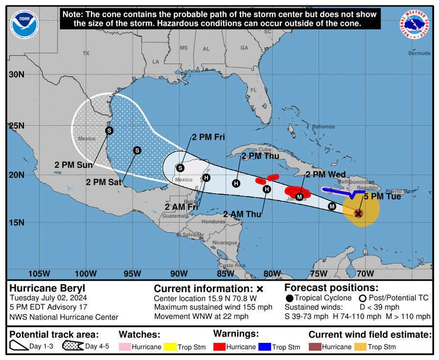
(5:30 PM CT update): Beryl is beginning to feel the shear as laid out in our post below, and it is now a category 4 storm with 155 mph winds. For folks in Jamaica, this offers modest comfort, as a major hurricane is going to make landfall (or come close) there tomorrow. Little has changed with respect to Jamaica and the Cayman Islands, so reference the post below on that.
I need to say some words to people in Houston. We are getting blasted by a few of you for apparently underselling the real threat from Beryl. If you read the post below, we’ve taken a very down the middle, neutral stance on the storm, explaining how it is still likely to pass to the south, though if it were to not weaken as much as forecast over the next 36 hours, it could come a bit farther to the north. We even went so far as to show the European ensemble models with the distribution of some closer to southeast Texas and others in Mexico, and we explained how this could be and what to watch for. I’m not quite sure what isn’t resonating with some people, but those are the facts. Here is a look at today’s most recent European ensemble members, 51 of them:
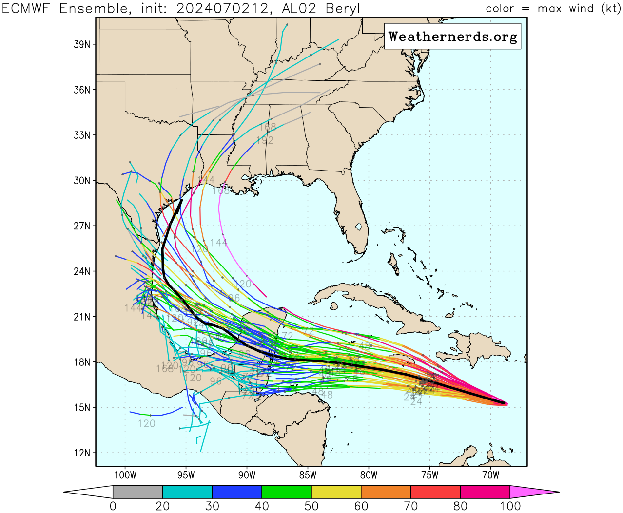
Of the 51 members, 5 of them or 9.8 percent bring Beryl into the Houston area or Louisiana. This is down from 8 earlier this morning. If you would rather the GFS Ensemble, 4 of the ensemble members, or about 13 percent bring it to Texas or Louisiana, the same as earlier. Roughly one tropical model (the HWRF) brings Beryl to Houston. The HWRF historically would handle a weakening tropical system poorly, so I would be apt to discount it in my weighting as a meteorologist with a number of years of experience tracking and forecasting these things.
I write all this to say: No one is saying to ignore Beryl. But, look, those statistics of objective model data imply that the risk to Houston remains…pretty low! Should we continue to watch this? Absolutely! And I laid out the case of how this could become more problematic in Texas below. So, let’s just take a breath and watch what happens over the next 24 to 36 hours.
Headlines
- Beryl remains a category 5 hurricane with 160 mph maximum sustained winds.
- Beryl is expected to make a direct hit on Jamaica tomorrow as a major hurricane.
- While Beryl is likely to weaken over the next 48 hours, it may not occur fast enough to drop under major hurricane intensity through Jamaica and possibly the Cayman Islands.
- Heavy rainfall and flooding are likely along and north of Beryl’s path in the Caribbean.
- Beryl’s forecast track remains dependent on a number of features as it comes west, but it has trended a little farther north today versus yesterday.
Hurricane Beryl (160 mph, WNW 22 mph)
Hurricane Beryl somehow managed to continue strengthening last night and achieved category 5 status late in the evening over the eastern Caribbean. It has maintained that status today and has 160 mph maximum sustained winds as it races west northwest across the Caribbean.
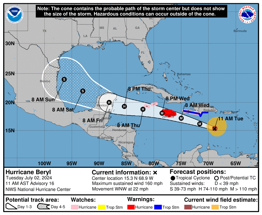
Over the next 36 hours, Beryl will remain on a course that should bring it very, very close to a direct hit on Jamaica. At the least, it will be a close pass, and hurricane conditions are expected there beginning late tonight or tomorrow morning. Preparations for a major hurricane impact should be rushed to completion in Jamaica. Folks in the Cayman Islands will need to watch Beryl closely as well as it passes near or just south of there tomorrow night.
On satellite, Beryl looked great this morning, and while it still looks great, there are at least some signs that shear is beginning to impact Beryl a bit on the west side.
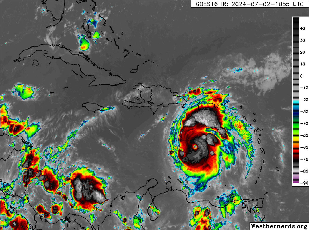
You can see a more ragged appearance to the eye and eyewall, and even what looks to be a little dry air just outside the core in the western semicircle of Beryl. Whatever the case, the thought is that Beryl’s intensity has peaked, and it should now begin to undergo a steady decline. Beryl is about to plow into 20 or more knots of wind shear.
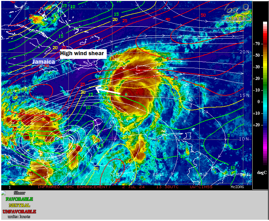
Wind shear is complicated with storms of this intensity. Theoretically, it should just start to feel the shear and begin a steady, if not rapid weakening. Modeling says this will be the case. The majority of modeling weakens Beryl to a category 2 or weaker storm by Thursday morning. But in storms of this intensity, shear can be a little funky and find ways to help the storm “ventilate” somewhat. In my opinion, this is not going to be the case with Beryl; it should weaken as forecast, perhaps at a slower rate than what models suggest. However, there is inherent uncertainty here, and that’s why we would tell folks in Jamaica to prepare for a serious, major hurricane.
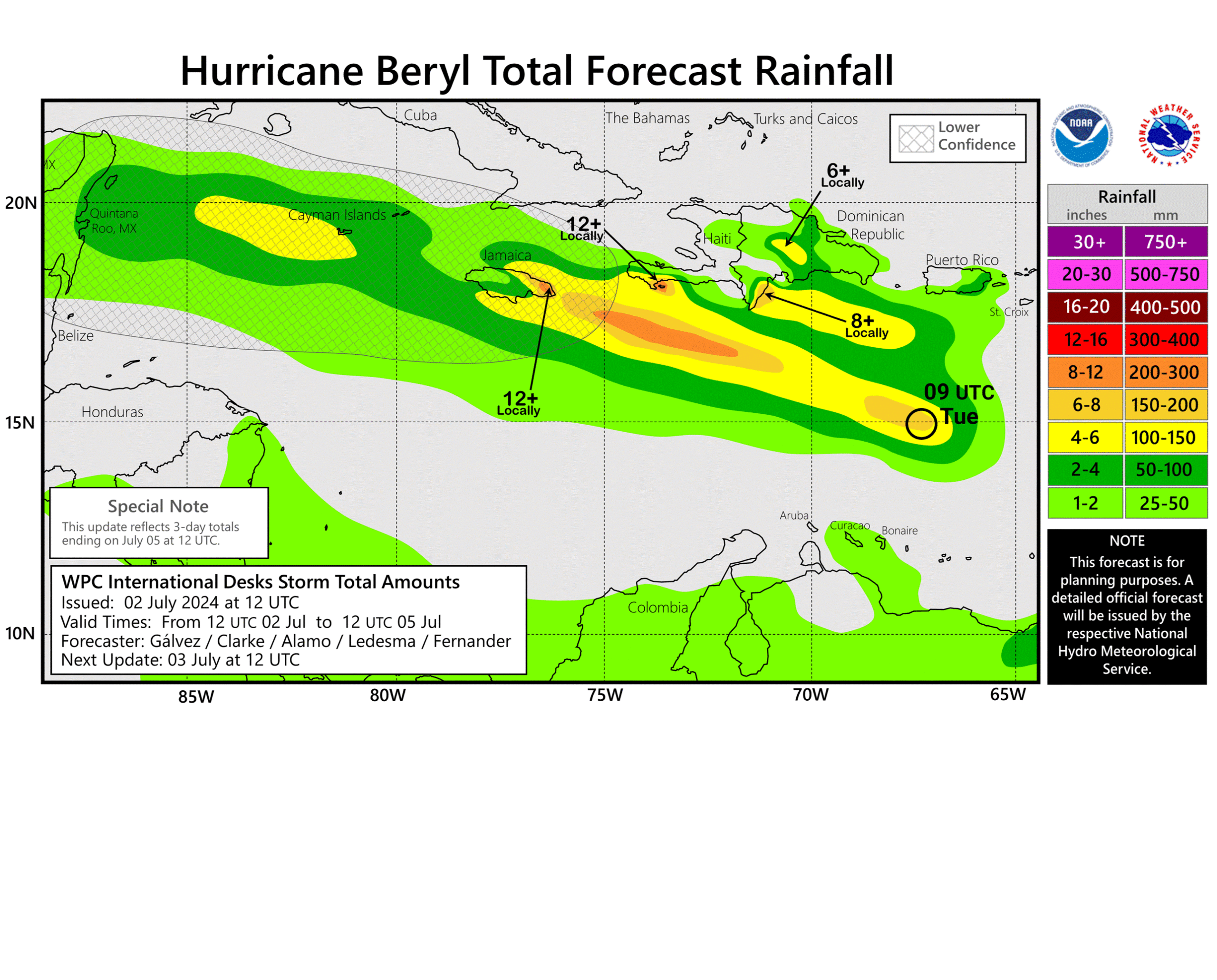
In addition to the wind and surge impacts of a major hurricane, flooding from rainfall is a possibility, if not likelihood as Beryl passes southern Hispaniola and Jamaica.
According to Sam Lillo of DTN weather, who has been posting frequent statistical nuggets on Twitter/X regarding Beryl’s unprecedented nature about Beryl’s forward speed. Over a 6 hour period, Beryl is the fastest known moving category 5 storm on record. As noted by him and some others, Hurricane Allen in 1980 and Janet in 1955 also had some extreme forward speeds for category 5 storms. Either way, Beryl will end up atop or near the top of many charts once all is said and done for earliest and easternmost and fastest for storms of this intensity.
What comes after Jamaica for Beryl?
The main near term concern is for the folks in Jamaica and the Caymans. Beyond that, the forecast is contingent on a number of factors. Over the last 48 hours, we’ve seen a slight northward shift in Beryl’s forecast track as it comes west.
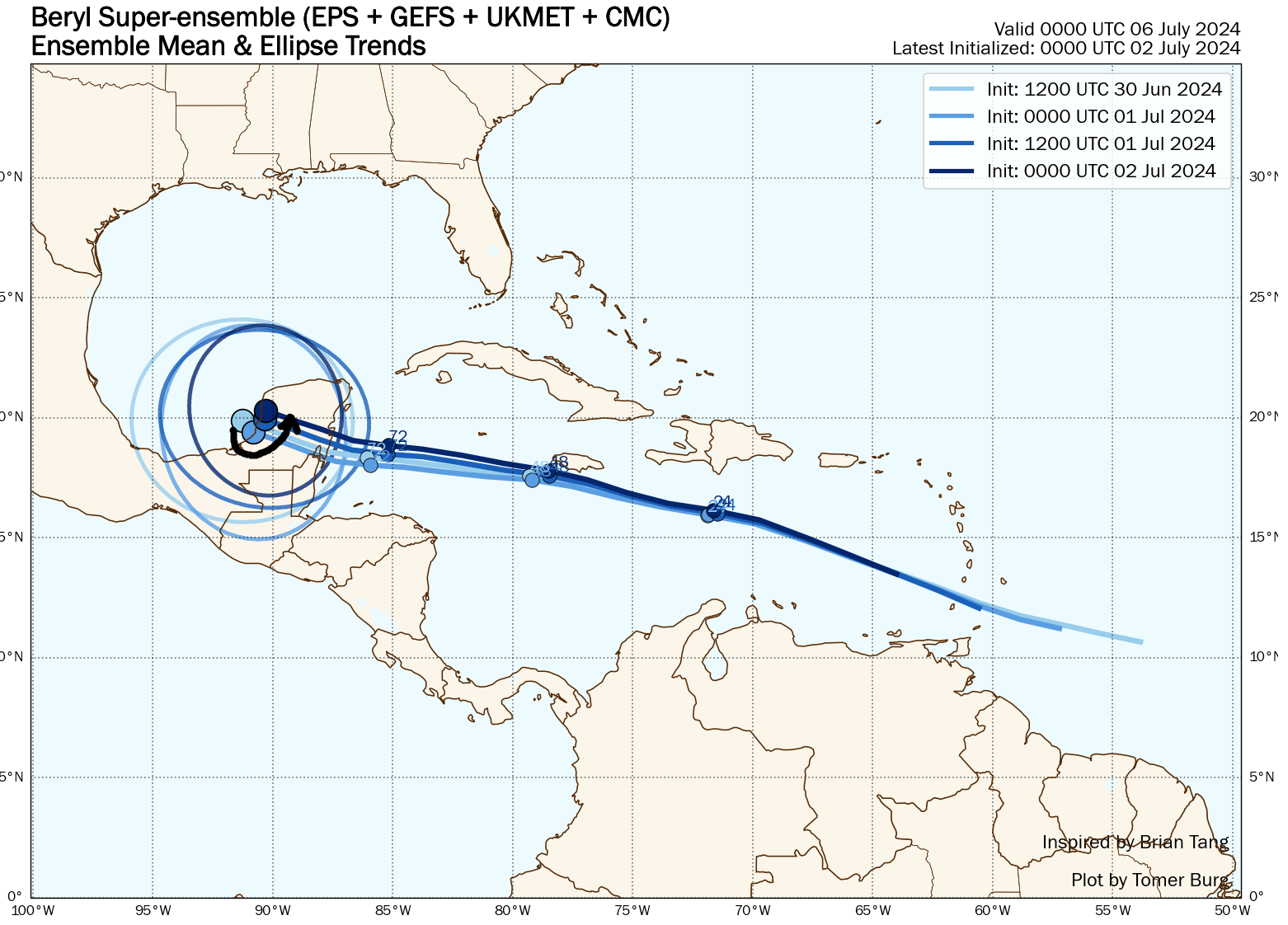
This has implications for the Yucatan and perhaps the Gulf as well. Why is Beryl trending more north? For one, exploding into a category 5 storm allows it to gain some added latitude. But secondly, the U.S. pattern has changed somewhat. If you look at how the European ensemble’s 6 to 10 day forecast has changed in the last 48 hours, the tendency has been for the trough over the Central U.S. to strengthen, thus weakening the ridge of high pressure in the South.
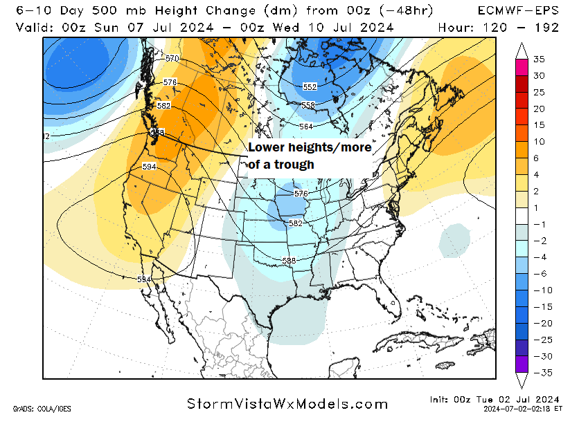
But there’s a lot of nuance to this. For one, if Beryl does weaken as expected, this would have only a modest impact on the final track, keeping it south across the Yucatan and into Mexico. If Beryl does stay stronger than forecast or somehow intensifies as it comes west into the Gulf, it would be more apt to “feel” the stronger trough and come north. You can see this on the Euro ensemble where stronger outcomes are mostly skewed north and weaker outcomes are mostly skewed south.
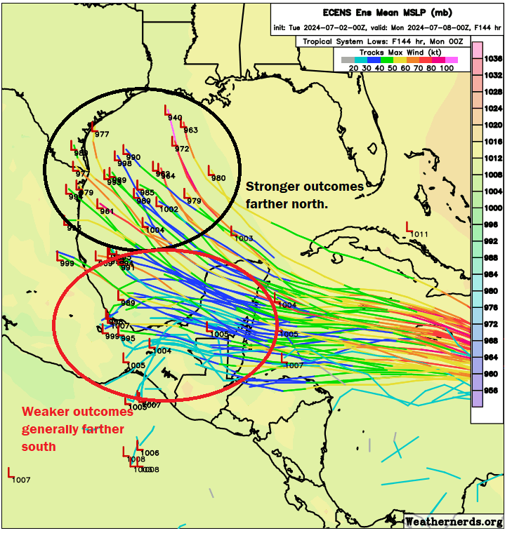
There’s a reason we have been apt to not speculate on what would happen to Beryl as it came west, rather trying to focus on what would impact Beryl. These changes offer a wrinkle. Should you worry on the Texas or Louisiana coasts? No, but you’ll want to keep an eye on this. For one, there seems to be a fair bit of support for somewhat hostile upper air conditions in the Gulf when Beryl arrives, so there’s no guarantee this will just explode when it gets there.
That said, we’re operating in a very odd world right now. Gulf of Mexico water temps have drifted under record levels thankfully, but it’s still warmer than normal overall. So I don’t want to overpromise anything at this point. The best we can tell people to do is continue watching. If Beryl makes it to the northern Mexico, Texas, or Louisiana coasts, the impacts would probably begin late Saturday night or Sunday.
One other quick word: A lot of people will be traveling this weekend to beaches and such. Rip current risk in the Gulf is going to increase later in the weekend as some of the swells from Beryl reach the coast.
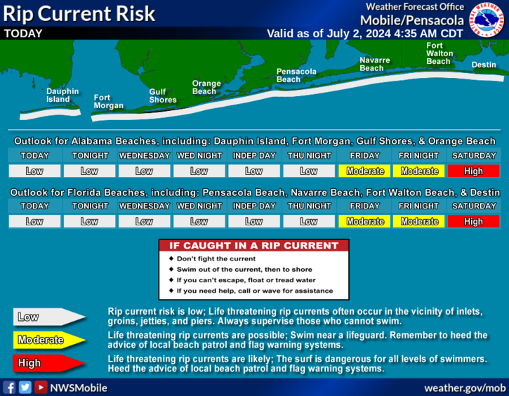
Please use caution if you’ll be on the beach this weekend. Even the best and most experienced swimmers can struggle with rip currents, so it’s advised to swim near a lifeguard and follow any warnings or caution notices.
Thank you, Matt.
Thank YOU Matt!
THANK YOU MATT!
I’m still in the Cayman Islands but was able to get on a United flight leaving 4:15 pm Wednesday. I’m guessing that’s too late to get out of here based on the arriving winds?
We will most likely have to hunker down and hopefully the speed of Beryl means it will pass quickly. The place I’m in survived Ivan so I think it can weather this.
Matt – thanks for the update. At what point along the path would you feel comfortable knowing the impacts Texas may feel from the storm or even coastal impact locations? Is this something we won’t really know until it hits the bay again? Seems like several more projections are leaning northward each update.
I am a thinking this is going to end up being more confidence on trends today and tomorrow, then specifics can start coming into view Thursday afternoon or Friday.
Thank you Matt for this update.
Thanks as always, Matt, for presenting the facts without the hype and panic. As a Houston-based weather nerd (and as tracking weather is a key part of my job in energy fundamentals forecasting), it’s easy for me to fall down the rabbit hole with some of the overhyped posts on twitter. I look to you and Eric to be the calming voice of reason in an online world filled with misinformation.
Hate to hear Cayman in the forecast. My favorite place to go 7 mile beach. Just got back from there June 23rd. Was there a week and had the most clouds and rain in June that I’ve ever had in June there. Prayers Up for both Jamaica and Cayman
“it has trended a little farther north today versus yesterday.”
Uh, yeah. Pretty much every model has something hitting Texas (or somewhere in the U.S.) now. I get the “hype-free” slant, but you shouldn’t err on the side of underhyping everything IMO. You’re becoming the boy who cried “we will continue to monitor the wolf situation” for the sake of being “hype-free”.
I don’t envy Matt and Eric. They put out an awesome, quality product for free out of their love for meteorology, Houston, and now all places affected by Atlantic tropical weather, and all people want to do is complain. If they say a storm “might” hit an area, people scream, “HYPE!” If they say a storm probably won’t hit an area, people complain they’re being over-cautious and following some agenda to hide the truth from us.
I don’t envy them either and appreciate their work. But if a storm might hit an area (and increasingly looks like it will), they should say the storm might hit the area. Sometimes that level of “hype” (forecasting) is appropriate and necessary.
And this doesn’t communicate that?!?
“Should you worry on the Texas or Louisiana coasts? No, but you’ll want to keep an eye on this.”
Don’t worry, but monitor. That is what he said. And based on the NHC forecast and what I can see in terms of modeling, that is a very appropriate recommendation at this point in time.
It is July. You should be prepared. Whether a storm is tracking towards us or not. If you are prepared, don’t have a heart attack stressing over it, just monitor it.
If you aren’t prepared …. well …. go get prepared. Again, this storm is irrelevant to that.
It doesn’t communicate anything. “don’t worry, monitor/keep an eye on it” is their plausible deniability go-to at this stage of every situation they cover. The communication should be (IMO, not a meteorologist, not Eric or Matt) that the models show it hitting Texas, so it might hit Texas. It’s the audience’s fault if they get hyped up over that.
Hmm… I get what you’re saying, but to be honest, I think they have communicated that sufficiently in these paragraphs:
“Of the 51 members, 5 of them or 9.8 percent bring Beryl into the Houston area or Louisiana. This is down from 8 earlier this morning. If you would rather the GFS Ensemble, 4 of the ensemble members, or about 13 percent bring it to Texas or Louisiana, the same as earlier. Roughly one tropical model (the HWRF) brings Beryl to Houston. The HWRF historically would handle a weakening tropical system poorly, so I would be apt to discount it in my weighting as a meteorologist with a number of years of experience tracking and forecasting these things.
“I write all this to say: No one is saying to ignore Beryl. But, look, those statistics of objective model data imply that the risk to Houston remains…pretty low! Should we continue to watch this? Absolutely! And I laid out the case of how this could become more problematic in Texas below.”
They still communicate that there could still be a chance shown in the models that the storm could hit the Houston area, but they have also communicated that the amount of model runs that shows the storm hitting the Houston area decreased from 8 this morning to 5 as of the time of this article. They bring up the GFS Ensemble as well stating that it has remained at 13%.
StartTrip56, they added those paragraphs of petulance after (and probably in response to) my comment, among others similarly calling out Matt for underselling everything. Matt rushed to post those spaghetti models since they moved South a bit relative to earlier models.
If the models move North again, don’t expect much discussion of them in the next post. That’s my forecast.
StarTrip56, they added those paragraphs of petulance after (and probably in response to) his comment and others calling Matt out for underselling everything. If the models move North tomorrow, don’t expect much discussion of them. That’s my forecast.
You can look at their posts before Imelda for reference. Oh wait, I can’t find any of those.
People’s extremism in every other aspect of life has eroded their understanding of nuance in cases where nuance is highly necessary. When I went through my geoscience undergrad in ’08 we spent a lot of time discussing the need for scientists to help bridge that gap between science and the community, a gap that was often riddled with misinterpretations by media and clumsily crossed by scientists who struggle to communicate effectively without the media. I believe bridging that gap is what Eric and Matt are doing and they continue to do it very well. But 2008 was vastly different from 2024. Now everyone is suspicious of anyone outside their micro-communities and so many people are what I would call “confidently wrong” in their understanding of how most science works. They aren’t ever looking to be corrected, only corroborated. Sometimes I feel like we’re on that Francis Scott Key Bridge and the 2024 election is that disabled container ship.
100% Sonorabee…excellent response. Thank you.
Well put!
Did you read anything I actually wrote? I explained AND LITERALLY SHOWED the mean trending a “little” north. And, no, for your information not “pretty much every model” has something hitting Texas. If you want to criticize us, that’s fine…just come with some actual criticism, not this nonsense about underhyping. I told you literally anything anyone can realistically say at this point. That’s not underhyping…that’s communicating within the bounds of the science. I get fed up with stuff like this. I said there’s a chance it could hit Texas, but i’m not going to bend over backwards to tell people to freak out about it. I’m not sure how much clearer one can be.
Hi! I actually read your site to stay calm, but given this afternoon’s model I kind of agree with the guy’s statement above. I think you should at least do an update. Jeff Masters blog is full of people thinking it will hit Houston as a cat 2.
They are pretty well educated, and this afternoon model runs look really bad for us. Too many people I talk to are not even aware it’s out there and they’re in Houston.
Thanks for the work you do in general!
Those people pounce on every model run as definitive and wishcast
Thanks Lisa! That’s why I come here LOL
The TV weather men are agreeing with this site, when my choice is being three houses up from the water in Laporte where I live, or evacuating to Kingwood where it floods, I sometimes panic I will admit it! Most of the time that feels like a unknowable conundrum in which there are no good choices to me.
Preach, Matt.
Thanks for all you do. I hear your frustration and it is warranted. I appreciate your measured, balanced forecasts.
Preach, Matt.
Thanks for all you do. I hear your frustration and it is warranted. I appreciate your measured, balanced forecasts.
Just for the record, most of the silent majority on here deeply appreciate your telling us just-what-you-think. You’re going to get it wrong sometimes for the same reason that “predicting the weather” is a euphemism for “wild guess,” and I promise you that the percentage of readers who get that is much larger than it seems from the comment sample.
We also realize that it’s much harder to be hype-free when you’re catching crap for it, so…thank you. You guys do us a hell of a service.
IMO this post is reasonable in every way. My take away is be wary and concerned but don’t change your plans.
He’s delivering the information in a way that allows the general public to better understand what is being shown to them. His track record speaks for itself. If you want it to resemble a Toyotathon commercial then look somewhere else.
I’m curious. At any point in your secondary education, where I’m assuming you finished or just stopped, did the curriculum of your school included any lessons in reading for content, critical thinking, or any sort of science that didn’t involve turning lead into gold or praying over an altar? If not, then we can all collectively understand why you are making the posts you do.
Don’t know why you’re simping for Matt. He’s too busy whinging over politics on Twitter to see your comment.
I’m starting a just-right-hype weather blog, and you should subscribe. For only $5/month, I’ll take Matt’s posts and add just a dash of panic and “I’ve got a baaaaadddd feeling about this.”
For the $7 Premium Membership, I’ll include the above and add in some wringing-of-hands.
(…cmon, man—all he can do is use the tools he’s expert at and tell you what those tools and his experience say is likely. Don’t ask him to lie to you.)
Thanks for the thoughtful and comprehensive update. I check this site for perspective each time NOAA releases a livestream.
Wasn’t there a little developing storm behind Beryl as well? Has that dissipated?
It’s struggling out there, but it’s not totally dead. Nothing notable about it at the moment though.
The physics of this freak storm & the implications of what’s to follow definitely have me worried. I thought we’d at least have till mid-August before this level of tension arose.
I hope that ridge holds and muscles Beryl into as much submission as possible.
Thanks for the update! This storm encouraged us to get all of our hurricane supplies ready “just in case”.
Thank you guys for all you do.
When was the last time we went through letters A, B, C in June?
Last year.
Thank you for all of information. I cover internal communications for weather items for a company in Houston and this site as well as SpaceCityWeather are both soo helpful. I have a colleague that is leaving for Cancun tomorrow morning through Tuesday…. What is your advice? I keep telling her not to go.
Thank you. I’m not sure why it seems y’all feel the need to justify your stance. You all do what you do, and you do it well. You present the facts that you have at the time. If/when circumstances change, you provide updates, and you admit when y’all were off. What more could anyone want? Those of us who trust you love you and what you do. The naysayers can go to their other sources.
Set up with a high backing off and a trough coming in remind me a bit of Ike. Total different scenario though. Keep up the great work. You and Eric are my weather Gods and I appreciate your no-nonsense delivery! Thank you!!
Matt and Eric, I rely on this site and I appreciate the hard work that is put into it by the two of you. No nonsense, straight facts.
Keep up the good work!
Thank you for clarifying. I think they’re are too many folks who want things RIGHT NOW and never learned that sometimes, you have to wait. You and Eric are the only weather forecasters I pay attention to that been true since Eric began the site.
Stick to doing things your way. I appreciate it.
Well stated. Thank you.
If this is a question answered before, I apologize. I’ve looked through previous posts and comments and see nothing about it. What is the heavy black line on the model forecast map?
That is the ensemble mean. In other words, there are 51 ensemble members. Each produces an individual forecast. Each has tweaks. What happens, however is that some of those 51 ensemble members dissipate or terminate the storm before it gets to Mexico, so the ensemble mean is just averaging what’s left, which seems weighted between wildly north and into Mexico. It’s a poor tool to use in these “termination bias” scenarios, and I wish we could take the line off the map. Alas, we’re just borrowing the graphic.
It’s the mean or median of all the projected paths. The average.
Thanks for the great work, Matt! Appreciate the information and the clear articulation!
Thank you, Matt!
If the European models are so often wrong, why don’t they improve their algorithms?
You are doing just fine. To demand absolute certainty is the behavior of a child. The rest of us adults can read, reason, and appreciate your factual information & analysis. Thank you.
Thank you for the twice daily updates. It’s amazing the records Beryl is hitting with speed, strength, and location. It makes me wonder what August will be like but we’ll have to wait and see what this summer brings. Appreciate all the information you share and the level tone as well.
Thanks for all you do! And kudos for putting up with the doofuses in the comments; I would’ve disabled them by now!
Thanks for all y’all do.
I’ll panic when you tell me to panic. Until then, I appreciate the hard work you put into keeping Houstonians informed.
Hey Matt, just curious about the ocean currents. I was looking through all the fun layers my Windy app has and clicked on the currents layer and saw some strong currents in the Carribean, but also ones in the Gulf that look like they would just suck any storm right up the Texas coast from the Yucatan. Are currents able to steer a huge storm or hurricane, or are storms that big unphased by ocean currents?
@Joe-go to the Space City Weather website, find the search field and type Imelda …you will see all the posts.
I follow these guys and Levi (Tropical Tidbits whom these guys reference) and personally know someone trained in interpreting the models.
I can confirm they’ve all been telling the same story. Over and over. I monitor those models like a hawk, and these guys have clearly articulated what they know and don’t know (yet) therefore none of the model run outcomes have been unexpected to me.
Like many others, I’ve been significantly impacted by these weather events (3 floods in 1 year with the worst being Harvey in which my house sat in 13ft of water).
I found Space City Weather after Harvey and have not turned back since. Are they 100% right 100% of the time? No, but that’s ok because they can’t be. Weather is too unpredictable which is why they 1) give caveats and 2) post a “lessons learned” summary when they missed it.
This alone deserves my respect.
In the last few years people have decided the only way to approach hurricane season is to fixate on every storm & stir up panic. Thank you for resisting that trend.
Matt and Eric, y’all can’t grasp the integral calm you gift a very high percentage of your followers and the unspoken appreciation so many have for your updates. Sadly, these days all naysayers want to do is tear down honesty and very education predictions. Thank you from the bottom of my heart.
Would you expect tides in Jamaica Beach/ West Galveston Island to be as high as with the recent Alberto